Order Total (1 Item Items):
Shipping Destination:

Map Cuba by Rand Mcnally (13 results)
Skip to main search results
Search filters
Product Type
- All Product Types
- Books (10)
- Magazines & Periodicals (No further results match this refinement)
- Comics (No further results match this refinement)
- Sheet Music (No further results match this refinement)
- Art, Prints & Posters (No further results match this refinement)
- Photographs (No further results match this refinement)
- Maps (3)
- Manuscripts & Paper Collectibles (No further results match this refinement)
Condition Learn more
- New (No further results match this refinement)
- As New, Fine or Near Fine (No further results match this refinement)
- Very Good or Good (3)
- Fair or Poor (No further results match this refinement)
- As Described (10)
Binding
- All Bindings
- Hardcover (1)
- Softcover (No further results match this refinement)
Collectible Attributes
- First Edition (2)
- Signed (No further results match this refinement)
- Dust Jacket (No further results match this refinement)
- Seller-Supplied Images (13)
- Not Print on Demand (13)
Language (2)
Free Shipping
- Free Shipping to U.S.A. (No further results match this refinement)
Seller Location
Seller Rating
-

MAP: " Cuba".from Rand McNally Atlas of the World
Language: English
Published by Rand McNally & Company, Chicago, IL, 1895
Seller: Dorley House Books, Inc., Hagerstown, MD, U.S.A.
Seller rating 4 out of 5 stars

Map
No Binding. Condition: Very Good. colored map (illustrator). colored 10.5' X 13" map of Cuba.
-

MAP: "Cuba, San Domngo, Baham Islands, Porto Rico, Lesser Antilles".from New Family Atlas of the World
Language: English
Published by Rand McNally & Co, Chicago, IL, 1888
Seller: Dorley House Books, Inc., Hagerstown, MD, U.S.A.
Seller rating 4 out of 5 stars
Map First Edition
No Binding. Condition: Very Good. Colored Map (illustrator). 1st. 11" x 14"; colored map Of Cuba, San Domngo, Baham Islands, Porto Rico, Lesser Antilles w/inset of the , Lesser Antilles; suitable for framing.
-
The Rand McNally New Library Atlas Map of Cuba (aka "Rand McNally & Co.'s Map of Cuba") with 5 insets.
Language: English
Published by Rand McNally & Co Map Publishers and Engravers, Chicago, 1914
Map
Hardcover. Condition: Very Good. Paper colour travelling map with detailed index to verso 50 x 54cm, folding into blue cloth case 11 x 17cm. Scale: 28.5 miles = 1 inch (main map), with variable scales for insets of Havana Harbour, Port Matanzas, Cardenas and Santa Clara Bays, Port of Cienfuegos, and Port of Santiago de Cuba. Paper lightly tanned, with short tear to top edge, creasing to a couple of corners, and small holes / short tears to intersections. Case gilt bright, some spotting, and fading at spine tail.
-

Map of Cuba
Publication Date: 1887
Seller: Art Source International Inc., Boulder, CO, U.S.A.
Seller rating 5 out of 5 stars

With the 19th century innovations of publishing and technology, the world became a smaller place and one which anyone could become acquainted with. As these changes blossomed, the fledgling company of Rand McNally realized the interest in small accessible material, and produced a pocket atlas. These maps carry handy reference information, and were up to date for the period. They include cities, some towns as well as some roads. They have their own charm and would be great for framing, and decorative use. This map measures 3 inches by 5 inches.
-

Map of Cuba
Publication Date: 1885
Seller: Art Source International Inc., Boulder, CO, U.S.A.
Seller rating 5 out of 5 stars
With the 19th century innovations of publishing and technology, the world became a smaller place and one which anyone could become acquainted with. As these changes blossomed, the fledgling company of Rand McNally realized the interest in small accessible material, and produced a pocket atlas. These maps carry handy reference information, and were up to date for the period. They include cities, some towns as well as some roads. They have their own charm and would be great for framing, and decorative use. This map measures 3 inches by 5 inches.
-

Rand McNally Popular Map of Cuba
Publication Date: 1938
Seller: Art Source International Inc., Boulder, CO, U.S.A.
Seller rating 5 out of 5 stars
Rand McNally & Company, still a major name in map publishing to this day, began as a small print shop opened in Chicago in 1856 by William H. Rand. The shop originally printed guidebooks and directories. In 1858, Rand hired Andrew McNally who was later to become a partner. Within the next few years, the shop got into the railroad business by starting to print railway tickets and schedules, a key step in the development of the company. The ticket printing led to the publishing of railway guides, and by 1872 Rand McNally and Company had the capacity to publish maps. This map of Cuba and Central America came from Rand McNallys Commercial Atlas. A highly successful run of atlases that lasted over a decade. These maps were primarily used by business, because of their accurate listing of railroads in operation as well as tables of statistical information. This map measures 12.5 inches by 18 inches.
-

Popular Map of Central America, Popular Map of Cuba
Publication Date: 1936
Seller: Art Source International Inc., Boulder, CO, U.S.A.
Seller rating 5 out of 5 stars
The 1936, sixty-seventh edition of the "Rand McNally Commercial Atlas and Marketing Guide" is unique in its inclusion of informative details. Each map is brightly colored; predominantly in orange and tan with blue oceans, lakes and rivers. Central America and, on a seperate map, Cuba are illustrated on this page. An inset on the map of Central America lists the departments on the region. The names of countries, states, important towns, lakes, rivers and major geological features are labeled. This map measures 12.5 inches by 19 inches.
-

Rand McNally Standard map of Cuba
Publication Date: 1932
Seller: Art Source International Inc., Boulder, CO, U.S.A.
Seller rating 5 out of 5 stars
Rand McNally & Company, still a major name in map publishing to this day, began as a small print shop opened in Chicago in 1856 by William H. Rand. The shop originally printed guidebooks and directories. In 1858, Rand hired Andrew McNally who was later to become a partner. Within the next few years, the shop got into the railroad business by starting to print railway tickets and schedules, a key step in the development of the company. The ticket printing led to the publishing of railway guides, and by 1872 Rand McNally and Company had the capacity to publish maps. This map of Cuba came from Rand McNally's Commercial Atlas. A highly successful run of atlases that lasted over a decade. These maps were primarily used by business, because of their accurate listing of railroads in operation as well as tables of statistical information. This map measures 12.5 inches by 9 inches.
-

McNally's 1928 Map of Cuba
Publication Date: 1928
Seller: Art Source International Inc., Boulder, CO, U.S.A.
Seller rating 5 out of 5 stars
This map was produced by Rand McNally and Co. as part of its 1928 Commercial Atlas of America. These maps are some of our favorite maps because of the large size of each map sheet. The detail shown on each map is exceptional because of the map size. These maps were intended to be used by business for shipping and other uses. Roads, railroads, rivers, and buildings are clearly shown. There is more detail on these maps than any others during this time period. This map measures 13.5 inches by 9.75 inches.
-
Cuba, map with advertising
Published by Rand McNally & Co., 1898
Seller: Antipodean Books, Maps & Prints, ABAA, Garrison, NY, U.S.A.
Association Member: ABAA ANZAAB ESA ILAB
Seller rating 3 out of 5 stars

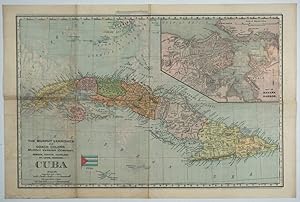
Maps. Condition: Otherwise very good condition. Color map of Cuba with inset map of Havana Harbor, issued at the time of the Spanish American War. Title at lower left with advertising, "The Murphy Varnishes and Coach Colors. Murphy Varnish Company, Newark, Boston, Cleveland, St. Louis, Chicago." above 'CUBA'. World map on verso. 21 x 14", color, original folds, slt. dusty on Cuba side.
-

McNally's 1922 Map of Cuba
Publication Date: 1922
Seller: Art Source International Inc., Boulder, CO, U.S.A.
Seller rating 5 out of 5 stars
This map of Cuba was produced by Rand McNally and Co. as part of its Commercial Atlas of America. The detail shown on each map is exceptional because of the map size. These maps were intended to be used by business for shipping, etc. Roads, railroads, and rivers are clearly shown. There is more detail on these maps than any others during this time period. This map measures 24.5 inches by 16 inches.
-

McNally's 1915 Map of Cuba
Publication Date: 1915
Seller: Art Source International Inc., Boulder, CO, U.S.A.
Seller rating 5 out of 5 stars
This map of Cuba was produced by Rand McNally and Co. as part of its Commercial Atlas of America. These maps are some of our favorite maps because of the large size of each map (25.5 x 20.5). The detail shown on each map is exceptional because of the map size. These maps were intended to be used by business for shipping and other uses. Roads, railroads, rivers, and buildings are clearly shown. There is more detail on these maps than any others during this time period. This map measures 25.5 inches by 19 inches.
-

McNally's 1891 Map of Cuba
Publication Date: 1891
Seller: Art Source International Inc., Boulder, CO, U.S.A.
Seller rating 5 out of 5 stars
First Edition
We are proud to offer this map of Cuba, originally produced as part of Rand McNally's Enlarged Business Atlas, dated 1891. Although the table of contents shows different editions starting in 1885, we believe this is the first edition of the Enlarged Atlas. Each of these maps accurately locates all cities, towns, post offices, railroad stations, villages, counties, parishes, islands, lakes, rivers, mountains and more. Until McNally�s enlarged Business Atlas, maps had never been produced that provided as much information as these do. Even today, we use these 130 year old maps to locate small towns, villages, and railroad routes that are no more. This map measures 19.75 inches by 13.25 inches.