
Order Total (1 Item Items):
Shipping Destination:

Map California by Augustus Mitchell (34 results)
Skip to main search results
Search filters
Product Type
- All Product Types
- Books (30)
- Magazines & Periodicals (No further results match this refinement)
- Comics (No further results match this refinement)
- Sheet Music (No further results match this refinement)
- Art, Prints & Posters (No further results match this refinement)
- Photographs (No further results match this refinement)
- Maps (4)
- Manuscripts & Paper Collectibles (No further results match this refinement)
Condition Learn more
- New (1)
- As New, Fine or Near Fine (No further results match this refinement)
- Very Good or Good (9)
- Fair or Poor (1)
- As Described (23)
Binding
Collectible Attributes
- First Edition (7)
- Signed (No further results match this refinement)
- Dust Jacket (No further results match this refinement)
- Seller-Supplied Images (26)
- Not Print on Demand (33)
Language (2)
Free Shipping
Seller Location
Seller Rating
-

Hardcover. Condition: Very Good. Moderate discoloration just inside front cover at top end, and mild spot discoloration at bottom end of rear cover. Otherwise in swell shape- the pages are clean and unmarked, and the binding is solid. Cover is embossed with decorative titling, cover and spine have dull gilt finish.
-
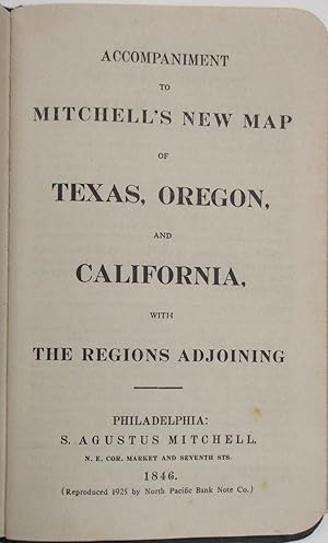
Accompaniment to Mitchell's New Map of Texas, Oregon, and California, with The Regions Adjoining
Language: English
Published by S. Augustus Mitchell, 1846
Seller: Friends of the Multnomah County Library, Portland, OR, U.S.A.
Seller rating 5 out of 5 stars

Hardcover. Condition: Fair. 1846. 46 pp. Book accompaniment only; map not included. Roan leather bound boards with blind stamping and gold leaf gilt tooling. Boards show wear to corners and edges with two small perforations on back board. White endpapers. Back pastedown has come loose, revealing pasteboard underneath. Spine of the text block has also loosened from the casing, but front endpapers remain secure and text block secured by front hinge. Back pastedown and final page (p. 46) show previous owner's signature. Final page also has small open tear in upper left corner; the rest of the pages remain untorn. Pages either clean or show slight staining; medium-sized stains on penultimate pages (pp. 44 and 45) from bled ink (see photos).
-
![Seller image for Description of Oregon and California, embracing an account of the gold regions ; to which is added, an Appendix, containing descriptions of various kinds of gold, and methods of texting its genuineness / [Samuel A. Mitchell] ; with a large and accurate map of Oregon and California, compiled from the latest authorities 1849 [LeatherBound] for sale by S N Books World](https://pictures.abebooks.com/inventory/md/md30637954947.jpg)
Description of Oregon and California, embracing an account of the gold regions ; to which is added, an Appendix, containing descriptions of various kinds of gold, and methods of texting its genuineness / [Samuel A. Mitchell] ; with a large and accurate map of Oregon and California, compiled from the latest authorities 1849 [LeatherBound]
Language: English
Publication Date: 2025
Leatherbound. Condition: NEW. BOOKS ARE EXEMPT FROM IMPORT DUTIES AND TARIFFS; NO EXTRA CHARGES APPLY. Leatherbound edition. Condition: New. Leather Binding on Spine and Corners with Golden leaf printing on spine. Bound in genuine leather with Satin ribbon page markers and Spine with raised gilt bands. Pages: 92. A perfect gift for your loved ones. Reprinted from 1849 edition. NO changes have been made to the original text. This is NOT a retyped or an ocr'd reprint. Illustrations, Index, if any, are included in black and white. Each page is checked manually before printing. As this print on demand book is reprinted from a very old book, there could be some missing or flawed pages, but we always try to make the book as complete as possible. Fold-outs, if any, are not part of the book. If the original book was published in multiple volumes then this reprint is of only one volume, not the whole set. IF YOU WISH TO ORDER PARTICULAR VOLUME OR ALL THE VOLUMES YOU CAN CONTACT US. Resized as per current standards. Sewing binding for longer life, where the book block is actually sewn (smythe sewn/section sewn) with thread before binding which results in a more durable type of binding. Language: English Pages: 92.
-
County Map Of California
Published by Philadelphia: S. A. Mitchell, 1860
Seller: ZH BOOKS, ABAA, ILAB, IOBA, Fremont, CA, U.S.A.
Association Member: ABAA ILAB IOBA
Seller rating 5 out of 5 stars
Softcover. 0 (illustrator). First edition; 12 1/2 x 15 1/4; hand-colored map; ornate engraved border; chips with some loss of paper to lower corners; foxing to lower right quarter; good.Published as part of the first edition of "Mitchell's New General Atlas," the map featured not only the State of California with each county, major cities, bodies of water, railroads, etc. outlined but also two smaller inset maps of Great Salt Lake Country, Utah and the San Francisco Bay Area. 3.
-

21 1/2 x 14 1/4 inches. Condition: Very good. Very nice map of California on a two page scale. A large map of San Francisco is in the upper right. A smaller map of the San Francisco Bay and Vicinity is in the lower left. Would look very nice framed!
-
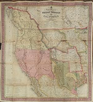
A New Map of Texas, Oregon, and California.
Published by Philadelphia: S. Augustus Mitchell, 1846., 1846
Seller: Arader Galleries - AraderNYC, New York, NY, U.S.A.
Seller rating 5 out of 5 stars
First Edition
Hardcover. 1st Edition. Single sheet (20 � x 19 � inches). 46-page "Accompaniment to Mitchell's New Map of Texas, Oregon, and California" (some spotting at beginning and end). Fine folding lithographed map with original hand color in full (separation along folds, some browning). Original publisher's blind stamped morocco gilt, preserved in a modern half green morocco slipcase, marbled boards with printed paper spine label (top half of backstrip lacking). Provenance: With contemporary manuscript ownership inscription of Augustus ?Scronsius. From the important cartographical library of Warren Heckrotte, his sale, Rare Cartography, Exploration and Voyages, Part II, December 3, 2015, Lot 192. First edition. Rare first edition of this important map of the West at a time of geographic discovery as well as political upheaval and change. The map is issued with the 46-page text "Accompaniment to Mitchell's New Map of Texas, Oregon, and California, with the Regions Adjoining." As noted in the Accompaniment, Texas has recently been annexed into the United States, and California is in limbo, "Upper California. This part of Mexico was declared independent in 1845. It has of late attracted much attention in the United States; a number of Americans are already settled in it, and many others are preparing to emigrate thither." Regarding Oregon, the Accompaniment declares that "the United States have an indubitable claim to the whole region of Oregon, from N. lat 42� to 54� 40', yet the government has several times proposed, from motives of accommodation, to adopt the 49th parallel of latitude as the dividing line." The proposed boundary line along the 49th parallel is shown on the map, though the coloring of Oregon still reflects joint occupation up to N. lat 54� 40'. "In the Upper California portion, Fremont is carefully followed, while further north Wilkes is followed. The boundary (to be) with Mexico is imperfectly shown but Texas appears with the magnified boundaries, including Santa Fe, of the 1844 Emory. The various claims to Oregon appear. The Accompaniment is of particular interest, containing perhaps the clearest statement of Oregon and California facts that came out of the period just prior to settlement of the former's boundaries and inclusion of the latter in the United States" (Wheat). Cowan p.433. Graff 2841. Howes M685. Wheat Transmississippi 520. Wheat Gold Rush 29. Martin & Martin, Maps of Texas and the Southwest, Plate 36 and p. 57. California 49, map 25. Sabin 49714.
-
A New Map of Texas, Oregon and California, with the Regions Adjoining. Compiled from the Most Recent Authorities.
Published by Philadelphia: S. Augustus Mitchell, 1846., 1846
Seller: Arader Galleries - AraderNYC, New York, NY, U.S.A.
Seller rating 5 out of 5 stars
First Edition
Hardcover. 1st Edition. Folding lithographed pocket map (22 4/8 x 21 inches) with original hand-colour in full (laid down at an early date on tissue). Bound after "Accompaniment to Mitchell's New Map of Texas, Oregon, and California, With the Regions Adjoining". Original black roan embossed in blind and lettered in gilt (rebacked). First edition. When published this was the most accurate map and emigrant information available, and self-avowedly compiled from "the Congressional Map of Texas, 1844, Kennedy's Map of Texas by Arrowsmith, Mitchell's Map of Texas, Ward's Map of Mexico, Fr�mont's Map of his explorations in Oregon, California, &c., 1842, 1843, 1844, Map of Lewis and Clarke's tour, Major Long's tour to the Rocky Mountains, Nicollet and Fr�mont's exploration of the country between the Mississippi and Missouri, the Congressional Map of the Indian territory, and Mitchell's Map of the United States" (page 3). Clearly showing the Oregon Road, and the Santa Fe trails from Independence, Missouri, and with a table of distances between Westport and Oregon City. "In the Upper California portion, Fremont is carefully followed, while further north Wilkes is followed. The boundary (to be) with Mexico is imperfectly shown but Texas appears with the magnified boundaries, including Santa Fe, of the 1844 Emory. The various claims to Oregon appear. The Accompaniment is of particular interest, containing perhaps the clearest statement of Oregon and California facts that came out of the period just prior to settlement of the former's boundaries and inclusion of the latter in the United State" (Wheat). "California" occupies the entire area of modern-day California, Arizona, Nevada, New Mexico, Utah, and Colorado. Texas is shown as a state of the Union, including a Panhandle that reaches north to the 42nd parallel and a border on the Rio Grande. This popular maps was published in several formats: pocket map with guide (as here), separate map in pocket folder (no guide), separate sheet map, map included with printed reference or general guides to the U.S., wall map, and inset on a larger wall map of the U.S. Another edition appeared in Mitchell's 1849 'Description of Oregon and California'. Cowan p.433; Graff 2841; Howes M685; Wheat Transmississippi 520; Wheat Gold Rush 29.
-
A New Map of Texas Oregon and California With the Regions Adjoining.
Published by Philadelphia, 1846., 1846
Seller: Arader Galleries - AraderNYC, New York, NY, U.S.A.
Seller rating 5 out of 5 stars
First Edition
Hardcover. 1st Edition. Single sheet (22 x 21 inches). Folding lithographic map with original color, linen backed (evidence of early repair, a bit browned). Modern cloth portfolio. Provenance: Near contemporary annotations recording journals westward. The rare first edition of this important map of the West at a time of geographic discovery as well as political upheaval and change. The table in the lower left-hand corner details the distances between way points of the "Emigrant Route from Missouri to Oregon" Other official routes indicated on the map but not described in detail are those of Fremont's explorations, the "Caravan Route from Missouri to Santa Fe," the "Great Spanish Trail from California to Santa Fe," and "Lt. Col. Cooke's wagon road." In addition a contemporary hand has marked the routes west taken by three emigrants "Ch. Verendige", "Alex" and "Whitney". Cowan p.433; Graff 2841; Howes M685; Wheat Transmississippi 520; Wheat Gold Rush 29.
-
A New Map of Texas Oregon and California with the Regions Adjoining. - Accompaniment to Mitchell's New Map of Texas, Oregon, and California, with the Regions Adjoining.
Published by S. Augustus Mitchell, Philadelphia, 1846
Seller: Arader Galleries - AraderNYC, New York, NY, U.S.A.
Seller rating 5 out of 5 stars
First Edition
Hardcover. 1st Edition. Single sheet (22 x 21 inches). Folding lithographic map with original color, tipped in after the "Accompaniment." (some folds strengthened on verso, but a FINE AND BRIGHT COPY of a fragile map). Original maroon morocco, covers elaborately decorated in blind, lettered in gilt within an elaborate border in the center of the front cover. Modern quarter maroon morocco clamshell box. Provenance: Penciled presentation inscription from "John B. Colahan to his friend Joseph Trasel Esq. Lodge Hall Aug 5. 1846" on the front free endpaper. The rare first edition, and AN EXCEPTIONALLY FINE COPY of this important map of the West at a time of geographic discovery as well as political upheaval and change. As noted in the "Accompaniment.", Texas has recently been gathered into the bosom of the United States, and California is in limbo, "Upper California. This part of Mexico was declared independent in 1845. It has of late attracted much attention in the United States; a number of Americans are already settled in it, and many others are preparing to emigrate thither." Regarding Oregon, the "Accompaniment." declares that "the United States have an indubitable claim to the whole region of Oregon, from N. lat 42o to 54o 40', yet the government has several times proposed, from motives of accommodation, to adopt the 49th parallel of latitude as the dividing line.". Wheat describes the map: "In the Upper California portion, Fremont is carefully followed, while further north Wilkes is followed. The boundary (to be) with Mexico is imperfectly shown but Texas appears with the magnified boundaries, including Santa Fe, of the 1844 Emory. The various claims to Oregon appear. The "Accompaniment." is of particular interest, containing perhaps the clearest statement of Oregon and California facts that came out of the period just prior to settlement of the former's boundaries and inclusion of the latter in the United States." Cowan p.433; Graff 2841; Howes M685; Wheat Transmississippi 520; Wheat Gold Rush 29.
-

13 1/2 x 10 3/4 inches. Condition: Very good. Nice single page map of California from Mitchell's General Atlas. Inset map of San Francisco in the Upper Right. Small scale map of San Francisco Bay and Vicinity in the lower left. The Central Pacific is shown running east of Sacramento. The Southern Pacific Railroad is shown as proposed and under construction heads south out of San Jose to the border with Arizona. The main line runs through San Bernardino and is attached to Los Angeles through a branch line. San Diego is avoided altogether.
-

County Map of California Map of the Settlements in the Great Salt Lake Country. Utah. San Francisco Bay and Vicinity.
Published by S. Augustus Mitchell, Philadelphia, 1860
13 1/2 x 10 3/4 inches. Condition: Very good. S. A. Mitchell (illustrator). 1860. Map of California printed by lithography and finished with very nice hand coloring in outline and wash.
-
COUNTY MAP OF CALIFORNIA; MAP OF THE SETTLEMENTS IN THE GREAT SALT LAKE COUNTRY. UTAH.; SAN FRANCISCO BAY AND VICINITY
Published by S. Augustus Mitchell, Philadelphia, PA, 1860
Seller: Aardvark Rare Books, EUGENE, OR, U.S.A.
Seller rating 5 out of 5 stars
First Edition
Map. Condition: Very Good Plus. First Edition. Hand-colored map of California's with inset maps of the Salt Lake region and San Francisco Bay; coloration denotes counties. Map: 13.5 in. x 10.5 in. Paper: 15.25 in. x 12.25 in. Ornate floral frame. In upper right corner outside of neatline is the number "51"; below the neatline iat bottom left is written: "Entered according to Act of Congress in the year 1860 by S. Augustine Mitchell, Jr. in the Clerks Office of the District Court of the U.S. for the Eastern District of Pennsylvania." Touch of tanning along top and bottom edges. Corners sharp. Published as page 51 in the first edition of "Mitchell's New General Atlas.".
-
1871.Mitchell.County Map of the State of California.LARGE SAN FRANCISCO INSERT
Published by Samuel Augustus Mitchell Jr., Philadelphia, 1871
Map
No Binding. Condition: VG+. Illustrated (illustrator). Third Edition. Folded with tape on back, slight bleep through on upper comers otherwise very nice condition. Map measures 15 1/4 by 23. The David Rumsey Collection at Stanford has 9 variations of this map first published in 1860, including 1870 and 1874. This 1871 printing corresponds to the 1870 one, so might be considered the Third Printing. I am showing the map with the matting it came in; but I can ship it without to save on postage particularly for International or Priority.
-

County Map of the State of California
Published by Bradley, Philadelphia, 1882
Seller: Nicholas D. Riccio Rare Books, ABAA, Florham Park, NJ, U.S.A.
Seller rating 4 out of 5 stars

Philadelphia: Bradley, 1882. Unbound, colored engraved map, decorative boarder, 22 1/2"x 14 1/2". Normal aging and toning, crease at center fold; overall very good plus. Maps are wrapped with acid free board, or in rigid sleeves. The Mitchell family started to produce atlases in 1846, and continued into the early 1890s. Around 1860, S. Augustus Mitchell Jr. took over, and the atlas would be called Mitchell's New General Atlas. This is an attractive map of California from the 1882 installment. The city of San Francisco is shown in an inset. Will require extra postage. Ristow 311-313 Phillips 907.
-
County Map of the State of California
Published by Philadelphia, 1869
Seller: Nicholas D. Riccio Rare Books, ABAA, Florham Park, NJ, U.S.A.
Seller rating 4 out of 5 stars
Philadelphia, 1869. Unbound, colored engraved map, decorative boarder, 14"x 11". Normal aging and toning; overall bright and clean. Maps are wrapped with acid free board, or in rigid sleeves. The Mitchell family started to produce atlases in 1846, and continued into the early 1890s. Around 1860, S. Augustus Mitchell Jr. took over, and the atlas would be called Mitchell's New General Atlas. This is an attractive map of California from the 1869 installment of that atlas. The city of San Francisco is shown in an inset. Ristow 311-313.
-

County Map of the State of California
Published by Philadelphia, 1865
Seller: Nicholas D. Riccio Rare Books, ABAA, Florham Park, NJ, U.S.A.
Seller rating 4 out of 5 stars
Philadelphia, 1865. Unbound, colored engraved map, decorative boarder, 14"x 11". Slight toning and aging, a few small chips at the edges; overall very bright and clean. Maps are wrapped with acid free board, or in rigid sleeves. The Mitchell family started to produce atlases in 1846, and continued into the early 1890s. Around 1860, S. Augustus Mitchell Jr. took over, and the atlas would be called Mitchell's New General Atlas. This is an extremely attractive map of California from the 1865 installment of that atlas. The city of San Francisco is shown in an inset. Ristow 311-313.
-
County Map of the State of California
Published by Philadelphia, 1870
Seller: Nicholas D. Riccio Rare Books, ABAA, Florham Park, NJ, U.S.A.
Seller rating 4 out of 5 stars
Philadelphia, 1870. Unbound, colored engraved map, decorative boarder, 14"x 11". Slight aging and toning; overall bright and clean. Maps are wrapped with acid free board, or in rigid sleeves. The Mitchell family started to produce atlases in 1846, and continued into the early 1890s. Around 1860, S. Augustus Mitchell Jr. took over, and the atlas would be called Mitchell's New General Atlas. This is an attractive double page map of California from the 1870 installment of that atlas. The city of San Francisco is shown in an inset. Ristow 311-313.
-
1866 Color Steel Engraved Map of UNITED STATES Florida Mexico California Canada
Published by Philadelphia : S. Augustus Mitchell, 1866., 1866
No Binding. Condition: Very Good. 1866 Color Steel Engraved Map of UNITED STATES Florida Mexico California Canada Samuel Augustus Mitchell (1790 1868) was an American geographer. Map maker: Samuel Augustus Mitchell Title: "Map of the United States and territories together with Canada" Atlas Title: Mitchell's New General Atlas containing maps of the various countries of the world, plans of cities, etc., embraced in fifty-eight quarto maps, forming a series of ninety-two maps and plans, together with valuable statistical tables. Published: Philadelphia : S. Augustus Mitchell, 1866. Note: double page map FREE SHIPPING WORLDWIDE Wear: wear as seen in photos Publisher: Philadelphia : S. Augustus Mitchell, 1866. Size: ~34in X 14in (85cm x 35.5cm) Photos available upon request.
-
ACCOMPANIMENT TO MITCHELL'S NEW MAP OF TEXAS, OREGON, AND CALIFORNIA, WITH THE REGIONS ADJOINING
Published by S. Agustus Mitchell, Philadelphia, 1925
Seller: David M. Lesser, ABAA, Woodbridge, CT, U.S.A.
Association Member: ABAA ESA ILAB SNEAB
Seller rating 5 out of 5 stars
34, [2 blanks] pp, with folding map, in color with decorative borders: "A New Map of Texas Oregon and California with the Regions Adjoining Compiled from the most recent authorities. . ." Very Good. The 1925 reproduction of one of the most significant maps of the period, so noted in Howes M685, Wagner-Camp 122b, Streeter Sale 2511.
-
![Seller image for County Map of California / Map of the Settlements in the Great Salt Lake Country. Utah [inset] / San Francisco Bay and Company [inset] for sale by Ken Sanders Rare Books, ABAA](https://pictures.abebooks.com/inventory/md/md31509691008.jpg)
County Map of California / Map of the Settlements in the Great Salt Lake Country. Utah [inset] / San Francisco Bay and Company [inset]
Published by S. Augustus Mitchell Jr., 1867
Seller: Ken Sanders Rare Books, ABAA, Salt Lake City, UT, U.S.A.
Association Member: ABAA ILAB IOBA RMABA
Seller rating 5 out of 5 stars
Map. Later printing. Color map [15 1/4 x 12 1/4"] Colored by county. Decorative vine-patterned borders. Three of the corners and the right margin chipped with slight loss. Plate 51 from "Mitchell's New General Atlas." Moffat 87. Samuel Augustus Mitchell, Jr. was the son of Samuel Augustus Mitchell, Sr., the most prominent American map publisher of his generation. Mitchell Sr. began publishing maps because he was frustrated with the low quality and inaccuracy of early 19th century maps. Samuel Augustus Mitchell, Jr. carried on the Mitchell family business until the late 1880s. (Information from National Museum of American History, Behring Center, Smithsonian Institution) Map of the Settlements in the Great Salt Lake Country is printed as an inset in the upper right of "County Map of California." Many new settlements are shown in Cache Valley.
-
No. 5 Map of the United States Engraved to Illustrate Mitchell's School and Family Geography [With] #6 [Inset] Map of the Gold Region of California
Published by Augustus Mitchell, Philadelphia, 1849
Seller: DogStar Books, Lancaster, PA, U.S.A.
Association Member: IOBA
Seller rating 5 out of 5 stars
Map
Map. Condition: Very Good. Hand colored map; Folio 13" - 23" tall; 1 pages; 1849. Augustus Mitchell. Double leaf folio sized map 10.50 H x 16.30 W Inches. Hand colored. Engraved by W. Williams. Scarce example unique to the 1849 published Mitchell's School Atlas. Inset map of the area west of San Francisco in "Upper California" extending just past the Sierra Nevada Mountains and delineating the many small rivers that were the focus of the 49er Gold Rush. Larger map includes frontier borders as they were in 1849 with Oregon Territory, the very large Missouri Territory, Indian Territory as well as a thin long oval with seaparate shading labeled as New Mexico, prior to the establishment of the New Mexico territory. Mild toning and soiling to borders; superficial handling / reader wear. Bright clean example of a scarce 49er map of the US. VG- to VG.
-
A NEW MAP OF TEXAS, OREGON AND CALIFORNIA. WITH THE REGIONS ADJOINING COMPILED FROM THE MOST RECENT AUTHORITIES. [Contained in:] A GENERAL VIEW OF THE UNITED STATES; COMPRISING, ALSO, A DESCRIPTION OF EACH INDIVIDUAL STATE AND TERRITORY IN THE UNION.
Published by Philadelphia: S. Augustus Mitchell, 1846., 1846
Seller: William Reese Company, New York, NY, U.S.A.
Association Member: ABAA ESA ILAB SNEAB
Seller rating 5 out of 5 stars
First Edition
The very important 1846 Mitchell map of Texas and the American West, here included as frontispiece to his General View of the United States, published the same year. Samuel Augustus Michell was one of the most influential map publishers in America in the 19th century, also producing numerous travel guides and statistical compilations to accompany them. The map present here is one of his most significant, representing "a great step forward, in that it is among the first by a commercial cartographer to utilize the recent explorations that had bounded and determined the nature of the Great Basin.because of its popularity, this map of the West exerted great influence, not only with the public but on other commercial cartographers" (Wheat). Published in 1846, this highly detailed "New Map of Texas, Oregon and California with the Regions Adjoining" would have been of immediate value to the public, who were focused with intense interest on the war breaking out on the Texas-Mexico border. It depicts the western portion of the United States to the Pacific, with Indian Territory, Missouri Territory, Iowa, and portions of the states of Missouri, Arkansas, Louisiana, and Wisconsin, as well as northern Mexico and part of British Columbia, illustrating in detail the trans-Mississippi region. The Santa Fe Trail and the Oregon Trail are both detailed, the latter with a table of distances published in the lower corner of the map. It is also deeply reflective of America's most aggressive land claims: Texas is elaborately depicted with the Rio Grande as its southern border, and Oregon is shown extended to 54deg 40". As one of if not the best commercial Western maps available, it played a part in some of the largest developments in the country at the time: Brigham Young, for example, ordered six copies before setting out for Utah that winter. The map was originally published with a short pamphlet very similar to the book offered here; it describes each territory or state in turn, with notes on Lewis and Clark and other early explorers, and more historical material. The General View of the United States which accompanies this copy provides detailed statistics, tables, and charts for every state in the Union as of 1840, including population, institutions of higher education, and details of mining and natural resources. The section on "Western States and Territories" prints much of the same information as the original accompaniment, including notes on Lewis and Clark, Pike, and Long, and additional details which Wheat calls "perhaps the clearest statement of Oregon and California facts that came out of the period just prior to the settlement of the former's boundaries and the inclusion of the latter in the United States." A valuable and historically important map, and highly illustrative of the explosive territorial expansion and concomitant conflicts of the 19th century. Map: HOWES M685, "aa." SABIN 49714. MARTIN & MARTIN 36. WAGNER-CAMP 122b. COWAN, p.433. WHEAT TRANSMISSISSIPPI 520. STREETER SALE 2511. PHILLIPS, MAPS, p.844. WHEAT GOLD REGIONS 29. REESE, BEST OF THE WEST 91. GRAFF 2841. Text: SABIN 49716. Original half cloth and printed paper boards. Boards a bit stained and soiled, extremities worn, neat cloth repairs to rear joint. Map: Light tanning and foxing, top edge slightly ragged, not touching image, two closed tears near where map is attached to gutter, repaired with paper on verso. Text tanned and foxed, a handful of early pencil annotations throughout and ownership inscription in ink on final page. A very good copy of the map, the text about the same.
-
A NEW MAP OF TEXAS OREGON AND CALIFORNIA WITH THE REGIONS ADJOINING. COMPILED FROM THE MOST RECENT AUTHORITIES (1846)
Published by S. Augustus Mitchell, Philadelphia, PA, 1846
Seller: Aardvark Rare Books, EUGENE, OR, U.S.A.
Seller rating 5 out of 5 stars
Map. Condition: Good Plus. Folding lithographic map, 22.75 in. x 21 in., with original color. Map is laid flat in archival plastic, and will be securely protected, and shipped in a mailing tube. Tanning to seams. Tape repairs and reinforcement on verso to all seams. Tiny losses of paper at six seam junctions. Storm 2841. Wagner-Camp 122b. This is Mitchell's third map of Oregon (the first being "Oregon and California" published in Mitchell's ;School and Family Geography;, and the second being "Mexico and Guatemala" which includes Upper or New California, New Mexico and Texas." (Wheat, Mapping The Transmississippi West 520). Carl Wheat described it as: ".a work of real importance, highly popular [and].on it the influence of the War wioth Mexico is strikingly revealed.It was among the first by a commercial cartographer to utilize the recent explorations that had bounded and determined the nature of the Great Basin. The Texas claim to a western boundary up the Rio Grande is here shown, with the northern panhandle extending all the way to the 42nd parallel.Because of its popularity, this map of the West exerted great influence, not only on the public but on other commercial cartographers." "The region covered by the map was of particular interest in 1846 because of two recent and related events. In 1845, Texas was admitted into the Union, which prompted Mexico to invade Texas in 1846, thus precipitating the U.S.-Mexican war. General curiosity about the new State of Texas and interest in the war with Mexico led to Mitchell's timely map becoming quite popular. Mitchell used the latest and best sources for the map, including Arrowsmith's 1841 map of Texas, Fremont's and Emory's maps of their explorations in the region, data from the Lewis & Clark expedition, Nicollet's map of the region between the Mississippi River and the Missouri River, Wilkes map of Oregon. Among other significant uses of the map, Brigham Young ordered 6 copies of the map and an example in the BYU collection includes an annotation placing the Mormons in Utah, pre-dating Fremont's map of 1848, which is the first printed map noting the presence of the Mormons in the Great Basin. The map shows Texas's claims to the Upper Rio Grande in present-day New Mexico -- eventually given up, as part of the Great Compromise of 1850, in exchange for the U.S. Federal Government's assumption of Texas's public debt. One of the most influential maps in Western American History." (from Stanford University Library).
-
A New Map of the State of California, the Territories of Oregon and Utah, and the Chief Part of New Mexico
Published by Thomas Cowperthwait & Co, Philadelphia, 1850
Seller: Ken Sanders Rare Books, ABAA, Salt Lake City, UT, U.S.A.
Association Member: ABAA ILAB IOBA RMABA
Seller rating 5 out of 5 stars
Hand-colored. 13" x 16 1/4" [20 1/2" x 23 1/2" in frame]. Near fine. A slightly later 1850 edition with "Utah Territory" rather than "Deseret." Moffat, 22. Wheat, Transmississippi West, 685. From Samuel Augustus Mitchell's "A New Universal Atlas." The Utah geography is taken from Fremont's 1845 map, with a channel between Utah Lake and Great Salt Lake. Salt Lake City is the sole settlement depicted. The Great Basin is labeled "Fremont Basin," and "Tueson" is shown fifty miles east northeast of Tubac.
-
A New Map of Texas, Oregon, and California, with the Regions Adjoining. Philadelphia: S. Augustus Mitchell, 1846. - Accompaniment to Mitchell's New Map of Texas, Oregon, and California, with the Regions Adjoining.
Published by Philadelphia: S. Augustus Mitchell, 1846., 1846
Seller: Arader Galleries - AraderNYC, New York, NY, U.S.A.
Seller rating 5 out of 5 stars
First Edition
1st Edition. "Single sheet (22 x 20 � inches). Folding lithographic map with original full hand coloring, tipped in after the "Accompaniment" (strengthened on verso, a bit stained). Original green leather binding, lettered in gilt within an elaborate embossed border in the center of the front cover (extremities a bit rubbed, but a FINE copy). Provenance: penciled ownership inscription of Jacob Warner, from Cincinnati, Ohio, on front free-end paper. The first edition, and A FINE COPY of one of Mitchell's most popular and important map. As noted in the "Accompaniment", Texas has recently been gathered into the bosom of the United States, and California is in limbo, "Upper California. This part of Mexico was declared independent in 1845. It has of late attracted much attention in the United States: a number of Americans are already settled in it, and many others are preparing to emigrate thither" Regarding Oregon, the "Accompaniment" declares that "the United States have an indubitable claim to the whole region of Oregon, from N. lat 42o to 54o 40', yet the government has several times proposed, from motives of accommodation, to adopt the 49th parallel of latitude as the dividing line". Wheat describes the map: "In the Upper California portion, Fremont is carefully followed, while further north Wilkes is followed. The boundary (to be) with Mexico is imperfectly shown but Texas appears with the magnified boundaries, including Santa Fe, of the 1844 Emory. The various claims to Oregon appear. The "Accompaniment" is of particular interest, containing perhaps the clearest statement of Oregon and California facts that came out the period just prior to settlement of the former's boundaries and inclusion of the latter in the United States." Cowan p.433; Graff 2841; Howes M685; Sabin 49714; Wheat Transmississippi 520; Wheat Gold Rush 29.".
-

County Map of the State of California
Publication Date: 1884
Seller: Art Source International Inc., Boulder, CO, U.S.A.
Seller rating 5 out of 5 stars
This map was made by S. Augustus Mitchell for "Mitchells New General Atlas" published in 1884, by WM. M. Bradley & Co. The well maintained maps in this atlas feature Mitchell's characteristic pastel coloring and abundant geographical features. Details include the names of counties, cities, towns, transportation routes, rivers, lakes, and mountain ranges. Regions are distinguished by color. These 1884 maps offer a fascinating perspective of areas that have since undergone significant growth and change, in addition to their value as great examples of Mitchell's work. This map measures 12 inches by 19.5 inches.
-

County Map of California
Publication Date: 1867
Seller: Art Source International Inc., Boulder, CO, U.S.A.
Seller rating 5 out of 5 stars
The Mitchell company was one of the first to try out the new technique of engraving on steel plates, experimenting with steel almost 20 years before the rest of the publishing industry. He was printing with steel in the early 1830s; the general switch to steel was approximately 1850. During the early years of the company, Mitchell published mainly maps and travel guides. In 1860, Mitchell started producing "Mitchell's New General Atlas", and Mitchell Sr. retired and turned the business over to his son of the same name. The New General Atlas was published until 1893. Today Mitchell maps are sought after for their fine engraving, bright coloring, and attention to detail. They are some of the finest maps produced in the 1860's. This map produced in 1867, has Mitchell's unique floral border, and beautiful hand coloring. This map details California,counties, cities, towns, transportation routes, and topographical features are illustrated. Two inset maps are included showing the San Francisco Bay and Vicinity and a Map of the Settlements in the Great Salt Lake Country,Utah. This map measures 10.5 inches by 13 inches.
-

County map of the state of California
Publication Date: 1878
Seller: Art Source International Inc., Boulder, CO, U.S.A.
Seller rating 5 out of 5 stars
This map was produced by Augustus Mitchell in 1878 for his New General Atlas. Highlights of this map are Mitchells traditional grapevine border, characteristic pastel coloring and abundant details of geographical features. This is a beautiful illustrated map of the state of California includes a large inset of the city of San Francisco and a smaller inset of the San Francisco Bay and vicinity. Surrounding towns and neighborhoods are distinguished by color. This 1878 map offers a fascinating perspective of areas that have since undergone significant growth and change, in addition to the value as great examples of Mitchell's classic mapmaking style. This map measures 14.5 inches by 21.25 inches.
-

County Map fo the State of California, with Insets of San Francisco and San Francisco Bay
Publication Date: 1875
Seller: Art Source International Inc., Boulder, CO, U.S.A.
Seller rating 5 out of 5 stars
This map was produced by S. Augustus Mitchell in 1875 for his New General Atlas. This map shows Mitchells traditional grape vine border, characteristic pastel coloring and abundant details of geographical features. Counties are distinguished by different colors. Wagon trails and major routes of transport are also shown. These 1875 maps offer a fascinating perspective of areas that have since undergone significant growth and change, in addition to their value as great examples of Mitchell's work. This map measures 15 inches by 21 inches.
-

Mitchell's 1865 County Map of California
Publication Date: 1865
Seller: Art Source International Inc., Boulder, CO, U.S.A.
Seller rating 5 out of 5 stars
In 1860 S. Augustus Mitchell Jr. took over his father's map publishing business and in that year he started publishing Mitchell's New General Atlas. Editions of the new general were issued annually until 1887. Mitchell Jr. continued publishing this atlas until 1879. The editions from 1880 to 1887 were published by Wm. M. Bradley. This map published in 1865 is a wonderful example of Mitchell's map-making prowess with beautiful original hand-coloring. This map measures 10.5 inches by 13.5 inches.


![Seller image for No. 5 Map of the United States Engraved to Illustrate Mitchell's School and Family Geography [With] #6 [Inset] Map of the Gold Region of California for sale by DogStar Books](https://pictures.abebooks.com/inventory/md/md30600820393.jpg)
![Seller image for A NEW MAP OF TEXAS, OREGON AND CALIFORNIA. WITH THE REGIONS ADJOINING COMPILED FROM THE MOST RECENT AUTHORITIES. [Contained in:] A GENERAL VIEW OF THE UNITED STATES; COMPRISING, ALSO, A DESCRIPTION OF EACH INDIVIDUAL STATE AND TERRITORY IN THE UNION. for sale by William Reese Company](https://pictures.abebooks.com/inventory/md/md32320277698.jpg)

