Order Total (1 Item Items):
Shipping Destination:

Map Cairo (124 results)
Skip to main search results
Search filters
Product Type
- All Product Types
- Books (57)
- Magazines & Periodicals (No further results match this refinement)
- Comics (No further results match this refinement)
- Sheet Music (No further results match this refinement)
- Art, Prints & Posters (13)
- Photographs (No further results match this refinement)
- Maps (51)
- Manuscripts & Paper Collectibles (3)
Condition Learn more
Binding
Collectible Attributes
- First Edition (9)
- Signed (No further results match this refinement)
- Dust Jacket (8)
- Seller-Supplied Images (93)
- Not Print on Demand (119)
Language (5)
Free Shipping
Seller Location
Seller Rating
-
Paperback. Condition: As New. Like new paperback. Covers show very minor shelf wear, otherwise an unblemished copy.; 100% Satisfaction Guaranteed! Ships same or next business day!
-

Egypt nel.map River Nile Valley-Cairo
Seller: WorldofBooks, Goring-By-Sea, WS, United Kingdom
Seller rating 5 out of 5 stars

Paperback. Condition: Very Good. The book has been read, but is in excellent condition. Pages are intact and not marred by notes or highlighting. The spine remains undamaged.
-

Condition: Good. Most items will be dispatched the same or the next working day. A copy that has been read but remains in clean condition. All of the pages are intact and the cover is intact and the spine may show signs of wear. The book may have minor markings which are not specifically mentioned.
-

map. Condition: Very Good. Fast shipping and order satisfaction guaranteed. A portion of your purchase benefits Non-Profit Organizations, First Aid and Fire Stations!
-

(trav eph ) Cairo and Environs New Pocket Guide Book- How to see them in a brief or longer stay- Tourist Map of City
Published by L. & L. Edition no date
Soft cover. Condition: Very Good. ed. paperback very good condition with a bit of wear- 62 pages with a folding map at the rear.
-

Cairo City Map
Language: English
ISBN 10: 8887177392 ISBN 13: 9788887177398
Seller: WorldofBooks, Goring-By-Sea, WS, United Kingdom
Seller rating 5 out of 5 stars
Paperback. Condition: Very Good. The book has been read, but is in excellent condition. Pages are intact and not marred by notes or highlighting. The spine remains undamaged.
-

Cairo Color Map
Language: English
Published by Independently published, 2019
ISBN 10: 1091244693 ISBN 13: 9781091244696
Paperback. Condition: Brand New. 24 pages. 8.50x8.50x0.06 inches. In Stock.
-

Map of Egypt Including Cairo and Alexandria Street Plans
Seller: Silver Trees Books, Malvern, WORCS, United Kingdom
Seller rating 5 out of 5 stars
Map
Hardcover. Condition: Good. Dust Jacket Condition: Good. Good map and cover. Externally very little wear original price sticker to rear small hole to front. Internally one small tear to a folded edge.
-

Egypt and Cairo Leisure Map (Holiday Maps)
Seller: Silver Trees Books, Malvern, WORCS, United Kingdom
Seller rating 5 out of 5 stars
Soft cover. Condition: Very Good. Dust Jacket Condition: Good. Very good map but covers a little creased and worn at the edges.
-
Tourist Map of Cairo - English, French, and German text
Published by Lehnert & Landrock no date, Cairo
PAPERBACK. Condition: Good+ with VG+ maps. no edition stated. two fold out maps in illustrated paper wraps, clean throughout, mapos are tight and unmarked, soiling and wear to the wraps. circa 1930s.
-
Tour Map of Islamic Cairo, City of 1001 Nights, and Shopper's Guide to Khan Al Khalili
Published by Maadi Graphics
Seller: Wonder Book, Frederick, MD, U.S.A.
Seller rating 5 out of 5 stars
Condition: Good. Good condition. (travel, tourism, guides, cairo, egypt) A copy that has been read but remains intact. May contain markings such as bookplates, stamps, limited notes and highlighting, or a few light stains.
-
Short Guide to the Chief Exhibits of the Cairo Museum of Antiquities: With Explanatory Notes and Map and Plan.
Published by Government Publications Office 1919, 1919
Seller: Hard to Find Books NZ (Internet) Ltd., Dunedin, OTAGO, New Zealand
Association Member: IOBA
Seller rating 5 out of 5 stars
Small paperback (VG); all our specials have minimal description to keep listing them viable. They are at least reading copies, complete and in reasonable condition, but usually secondhand; frequently they are superior examples. Ordering more than one book will reduce your overall postage cost.
-

Map. Condition: Used; Good. **SHIPPED FROM UK** We believe you will be completely satisfied with our quick and reliable service. All orders are dispatched as swiftly as possible! Buy with confidence! Greener Books.
-

bg810� A specialist undated but modern published postcard of this map of Cairo Underground unused and mint.
-
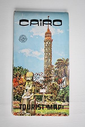
CAIRO TOURIST MAP
Published by CAiro Drafting Office, Cairo
Seller: David H. Gerber Books (gerberbooks), Austin, TX, U.S.A.
Seller rating 5 out of 5 stars
Fold-out Map in wrappers. Condition: Very Good. A.M. Rashdan (illustrator). no date [ca.1962] Map folds out to approximately 13-5/8 x 19-3/4 inches [3 places in index underlined] Size: 12mo - over 6�" - 7�" tall.
-
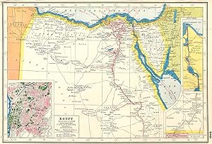
Condition: Good. EGYPT. inset Cairo & Suez canal . HARMSWORTH 1920 old antique map plan chart. Vintage colour map. Scale 1:5,000,000; Harmsworth (1920). 22.0 x 33.0cm, 8.75 x 13 inches. Condition: Good. There are images and/or text printed on the reverse side of the picture. In some cases this may be visible on the picture itself or around the margin of the picture.
-
A New Map of Cairo U.A.R. ( United Arab Republic ) / Nouveau Plan du Caire / Neuer Stadtplan von Kairo / Nueva Planta de Cairo / Pianti di Cairo.
Language: English
Published by Cairo Drafting Office, Cairo, 1966
Map
Soft cover. Condition: Very Good. Colour travelling map 94 x 69cm folding into illustrated card wraps 12 x 24cm. Map very good with bright colours, tear to one panel where it attaches to wraps, and small holes to a couple of intersections. Wraps very good, lightly creased and dusted. This map shows Cairo during the short-lived United Arab Republic (UAR) on a scale of 7 cm to 1 km. It covers Imbaba Airport (NW) - Madinet Nasr (NE) - Muqattam City (SE) - El Giza (SW). There are 5 insets: El Maadi, Helwan, Giza Pyramids, Cairo & Environs, Heliopolis.
-
Map of "Lower Egypt" from the 1920 Times Survey Atlas (Plate 79) including Suez Canal and plans of Cairo, Port Said and Suez and environs
Published by The Times, London, 1920
Map First Edition
Softcover. Condition: Very Good. Dust Jacket Condition: No Dust Jacket. First Edition. Disbound single sheet with vertical centre fold from the 1920 "The Times Survey Atlas of the World". Map is in colour and suitable for framing. Map at scale 1:1,000,000 with two inset continuation panels and a further three plans; Environs of Cairo at 1:150,000 and Suez and Port Said at 1:50,000. Map covers Egypt (part), Alexandria, Rosetta, Damietta, Ismailiya, Port Said, Suez Canal, Cairo, Helwan, Pyramids of Abusir and Saqqara, Medina, Minia, Asyut, Tahta, Ekhmim, Wady Natrun, etc. Slightly darkened edges with some occasional foxing in margins. Top edge of sheet is bumped and has slightly heavier foxing but sheet is otherwise clean and crisp. Item Type: Map. Single sheet map/chart which is suitable for framing and will be shipped rolled and in a cardboard tube. Quantity Available: 1. Shipped Weight: under 1 kg. Pictures of this item not already displayed here available upon request. Inventory No: 45020034050. All our books are sent by tracked mail.
-
Egypt and Cairo. A Clyde leisure map. With Plans of:- The Giza Pyramids, Alexandria, Luxor/Thebes. English, Deutsch, Francais.
Language: English
Published by Clyde Surveys Limited, Maidenhead, UK
Soft / Card Covers. Condition: Fine. Undated [1980s]. Blue, laminated covers. Colour map folded into 24 sections; text and captions in 3 languages. A clean, tight copy which appears unused. Image availlable upon request. [We welcome enquiries by e-mail - click on 'Ask Bookseller a Question'; or by 'phone - click on 'More Books from this Seller'].
-
Soft cover. Condition: Very Good. Colour map of Cairo with insets for the environs, and directory to the verso 53 x 80cm, folding down into colour wraps 12 x 23cm with metro map and 16pp booklet bound in (Brief History of Cairo, maps, and index). Undated c 1980s-90s. Very good, lightly worn.
-
Short Guide to the Chief Exhibits of the Cairo Museum of Antiquities; With Explanatory Notes and Map and Plan
Published by Government Press, Cairo, 1920
Seventh edition. 112mo. 91 pp. Softcover binding, very good condition. (96779).
-
EGYPT, Between Cairo and the Suez Canal - An Antique Coloured Map Printed Circa 1882
Language: English
Published by William Mackenzie, Edinburgh, 1882
Seller: K Books Ltd ABA ILAB, York, YORKS, United Kingdom
Association Member: ABA ILAB PBFA
Seller rating 5 out of 5 stars
No Binding. Condition: Very Good. J Bartholomew (illustrator). An attractive original antique coloured map . Mounted - matted - and ready to frame . Very good condition . Somewhat uncommon . Shows the area of Egypt between Cairo and the Suez Canal to illustrate military operations of 1882. Unobtrusive central fold.
-
Map. Condition: Good+. Dust Jacket Condition: No Dust Jacket. Slightly Worn.
-
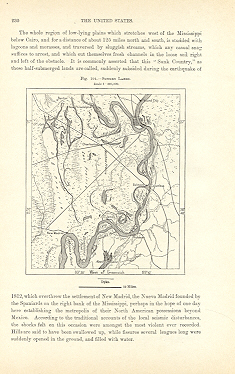
CAIRO,THE SUNK COUNTRY,ARKANSAS RIVER,1893 Map
Published by Reclus
Seller: Artisans-lane Maps & Prints, Victoria, BC, Canada
Seller rating 4 out of 5 stars

Art / Print / Poster
no binding. Condition: very good. CAIRO,THE SUNK COUNTRY,ARKANSAS RIVER ,1893,Antique Historical Relief Map CAIRO - THE SUNK COUNTRY - ARKANSAS RIVER 1893 Historical Map - Wood Engraving Approx Image Size: 4 1/4 x 5 Overall Page Size: 10 1/2 x 7 ins PRINT SHOWS: CAIRO, a city and the county-seat of Alexander county, Illinois, U.S.A., in the S. part of the state, at the confluence of the Ohio and Mississippi rivers, 365 m. S. of Chicago. Pop.(1890) 10,324; Cairo is served by the Illinois Central, the Mobile & Ohio, the Cleveland, Cincinnati, Chicago & St Louis, the St Louis, Iron Mountain & Southern, and the St Louis South-Western railways, and by river steamboat lines. The city, said to be the Eden of Charles Dickenss Marlin Chuzslewit, is built on a tongue of land between the rivers, and has suffered many times from inundations, notably in 1858. It is now protected by great levees. A railway bridge (1888) spans the Ohio. The city has a large government building, a U.S. marine hospital (1884), and the A. B. Safford memorial library (1882), and is the seat of St Josephs Loretto Academy (Roman Catholic, 1864). Excellent Condition. Map Image is clean, clear, sharp with beautiful detail. Intext Bookplate Map with Intext Map on the back. Printed on cream color coated paper.I prefer paypal or money orders. Delivery time for items can be anywhere from 10-28 days depending on your location. Items will be shipped within 2 business days of payment received. Checks will need time to clear before items are sent.
-
Map Of Cairo
Language: English
Published by Moharrem Press, Cairo, Egypt, 1961
Soft cover. Condition: Near Fine. Date: 1961. Folding map. Size: 50.8cm x 47.3cm. Map is vibrant, bright and clean and in lovely condition. The reverse gives details of the entertainments and nightclubs in Cairo along with information on tours and cruises. Produced in the final year of the United Arab Republic before its dissolution. In near fine condition overall.
-

Soft cover. Condition: Very Good. Cairo street map circa 1960, with lists of hotels, museums and monuments, and restaurants. By the Ministry of Tourism, Egypt, Akhbar El Yom Press.
-
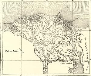
CAIRO AND THE DELTA OF THE NILE ,ANTIQUE 1880s WOOD ENGRAVED MAP
Published by Reclus
Seller: Artisans-lane Maps & Prints, Victoria, BC, Canada
Seller rating 4 out of 5 stars
Art / Print / Poster
no binding. Condition: very good. 1880s HISTORICAL RELIEF MAP CHART SHOWING TERRAIN, TOPOGRAPHY, ENVIRONS Approximate Image Size : 4 1/2 x 4 inches Approximate Overall Size: 7 x 10 1/2 inches Cairo is located on the banks and islands of the Nile River in the north of Egypt, immediately south of the point where the river leaves its desert-bound valley and breaks into three branches into the low-lying Nile Delta region. The oldest part of the city is somewhat east of the river. There, the city gradually spreads west, engulfing the agricultural lands next to the Nile. These western areas, built on the model of Paris by Ismail the Magnificent in the mid-19th century, are marked by wide boulevards, public gardens, and open spaces. The older eastern section of the city is very different: having grown up haphazardly over the centuries it is filled with small lanes and crowded tenaments. While western Cairo is dominated by the government buildings and modern architecture, the eastern half is filled with hundreds of ancient mosques that act as landmarks. Extensive water systems have also allowed the city to expand east into the desert. Bridges link the Nile islands of Gezira and Roda, where many government buildings are located and government officials live. Bridges also cross the Nile attaching the city to the suburbs of Giza and Imbabah (part of the Cairo conurbation). West of Giza, in the desert, is part of the ancient necropolis of Memphis on the Giza plateau, with its three large pyramids, including the Great Pyramid of Giza (last surviving of the Seven Ancient Wonders of the World). Approximately 11 miles (18 km) to the south of modern Cairo is the site of the ancient Egyptian city of Memphis and adjoining necropolis of Saqqara. These cities were Cairo's ancient predecessors, when Cairo was still in this approximate geographical location. CONDITION: BOOKPLATE INTEXT MAP - Excellent Condition. Map Image is clean, clear, sharp with beautiful detail. As scanned. There is TEXT AND INTEXT ENGRAVING ON THE REVERSE SIDE. Printed on cream color coated paper. NOTE THE FOLLOWING BEFORE YOU PURCHASE: This is a GENUINE 1800s Antique Map PRINT. It is NOT a modern reproduction, ie. a laser scan, photocopy etc. It is the original from the antique atlas or book publication. This map was published on the date mentioned, or circa of the date mentioned at the top of the page. The map print I have for sale, like many 1800s Antique Maps and prints that you see online, originate from an antique book or atlas publication. The publication may not always be known. If you have any questions, emails are welcome.
-

Cairo How To See It With Map and 40 Illustrations
Published by Alexandria, Egypt: The Anglo-Egyptian Supply Assoc., 1923, 1923
small 12mo. 171 pages; black & white illustrations; chipped covers else a very good, clean, tight copy.
-
Condition: Fair. NORTH AFRICA. Morocco Algeria Tunis Tunisia Egypt. Cairo. BARTHOLOMEW 1901 map. Antique colour map; John Bartholomew (1901). 33.5 x 44.0cm, 13.25 x 17.25 inches; this is a folding map. Condition: Fair: Two small tears in top margin not extending inside the border of the map. There is nothing printed on the reverse side, which is plain.