

Order Total (1 Item Items):
Shipping Destination:

Madrid by Society Diffusion Useful Knowledge (5 results)
Skip to main search results
Search filters
Product Type
- All Product Types
- Books (3)
- Magazines & Periodicals (No further results match this refinement)
- Comics (No further results match this refinement)
- Sheet Music (No further results match this refinement)
- Art, Prints & Posters (1)
- Photographs (No further results match this refinement)
- Maps (1)
- Manuscripts & Paper Collectibles (No further results match this refinement)
Condition Learn more
- New (No further results match this refinement)
- As New, Fine or Near Fine (1)
- Very Good or Good (2)
- Fair or Poor (No further results match this refinement)
- As Described (2)
Binding
- All Bindings
- Hardcover (No further results match this refinement)
- Softcover (1)
Collectible Attributes
- First Edition (No further results match this refinement)
- Signed (No further results match this refinement)
- Dust Jacket (No further results match this refinement)
- Seller-Supplied Images (4)
- Not Print on Demand (5)
Language (1)
Price
- Any Price
- Under £ 20 (No further results match this refinement)
- £ 20 to £ 35 (No further results match this refinement)
- Over £ 35
Free Shipping
- Free Shipping to U.S.A. (No further results match this refinement)
Seller Location
Seller Rating
-

Soft cover. Condition: Very Good. Antique Map.hand-colored outline; 13x16"/32x41cm. CLEAN!
-

Madrid.
Published by London, Baldwin & Cradock, 1831. 320 x 375mm (12½ x 14¾ inches)., 1831
Seller: Tooley, Adams & Co., Wallingford, OXON, United Kingdom
Seller rating 3 out of 5 stars

Original outline colour; light age-toning to the edges of the margins, minor soiling, otherwise a very good example. An early Victorian detailed plan of the city, drawn by W.B.Clarke and engraved by J.Henshall, with the important buildings in profile along the bottom. From the 1844 edition published by Chapman & Hall for The Society for the Diffusion of Useful Knowledge.
-

Madrid.
Published by London, Thomas Letts, [1877]. 320 x 375mm (12½ x 14¾ inches)., 1877
Seller: Tooley, Adams & Co., Wallingford, OXON, United Kingdom
Seller rating 3 out of 5 stars
Original outline colour; very light age-toning to the edges of the margins, otherwise a fine example. A Victorian detailed plan of the city, drawn by W.B.Clarke and engraved by J.Henshall, with the important buildings in profile along the bottom. From the 1877 edition published by Thomas Letts for The Society for the Diffusion of Useful Knowledge.
-
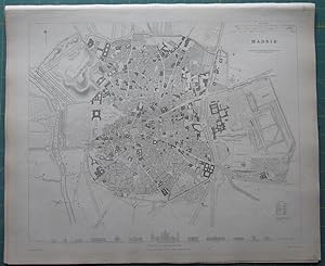
Madrid
Published by Charles Knight, 1851
Seller: Angelika C. J. Friebe Ltd. - MapWoman, Dorking, United Kingdom
Seller rating 4 out of 5 stars

Map
No Binding. Condition: Very Good. steel engraved town plan; 30 x 37 cm; exc. cond. Very detailed town plan of Madrid, published by the Society for the Diffusion for Useful Knowledge. The Society started to publish maps of the world as a compendium to the ?Library of Useful Knowledge? from 1829 onwards. Their aim was to reach a large market by keeping production costs and end prices down but , nevertheless, their maps excelled in high quality, details, accuracy and their decorative appeal. [ref: 1863 ].
-

Map of Madrid, Spain
Published by London, 1857
Seller: Trillium Antique Prints & Rare Books, Franklin, TN, U.S.A.
Seller rating 2 out of 5 stars

Art / Print / Poster
Condition: Fine. This originally hand-colored engraving is from "The Complete Atlas of Modern, Classical and Celestial Maps, together with Plans of the Principal Cities of the World". The work was published in 1857 by Edward Stanford for the Society for the Diffusion of Useful Knowledge. --- The work is in very good to excellent condition. There may be a few minor imperfections to be expected with age. Please review the image carefully for condition and contact us with any questions. --- Paper Size ~ 14" by 16 7/8".


