
Order Total (1 Item Items):
Shipping Destination:

Isles Sonde Sumatra Java Born�o (23 results)
Skip to main search results
Search filters
Product Type
- All Product Types
- Books (6)
- Magazines & Periodicals (No further results match this refinement)
- Comics (No further results match this refinement)
- Sheet Music (No further results match this refinement)
- Art, Prints & Posters (No further results match this refinement)
- Photographs (No further results match this refinement)
- Maps (17)
- Manuscripts & Paper Collectibles (No further results match this refinement)
Condition Learn more
- New (No further results match this refinement)
- As New, Fine or Near Fine (1)
- Very Good or Good (5)
- Fair or Poor (No further results match this refinement)
- As Described (17)
Binding
Collectible Attributes
- First Edition (2)
- Signed (No further results match this refinement)
- Dust Jacket (1)
- Seller-Supplied Images (22)
- Not Print on Demand (23)
Language (3)
Free Shipping
- Free Shipping to U.S.A. (No further results match this refinement)
Seller Location
Seller Rating
-
Le Monde Malais - P�ninsule Malaise - Sumatra - Java - Born�o - Cel�bes - Bali Et Les Petites Isles De La Sonde - Moluques - Philippines
Language: French
Published by Payot, Paris, 1946
paperback. Condition: Good. Payot; Paris, 1946. Trade paperback. Text in French. A Good, binding intact but a bit fragile, some handling/scuff marks and sunning to covers and spine, bit of cover edge/corner wear, couple of faint pencil numbers top front cover, creasing bottom front cover corner, stress crease and several small moisture spots on spine, text block edges a bit pulpy, age toned text block, previous owner handwritten ink info top front free endpaper, tear to page 45 to 48, ink markings to foreword page, small tears top and bottom spine edges, few uncut pages, some biblichor, a good and overall clean copy in wraps. 8vo[octavo or approx. 6 x 9], 510pp., with 32 sketches and 32 photographs. We pack securely and ship daily w/delivery confirmation on every book. The picture on the listing page is of the actual book for sale. Additional Scan(s) are available for any item, please inquire.Please note: Oversized books/sets MAY require additional postage then what is quoted for 2.2lb book.
-

Le Monde Malais - P�ninsule Malaise - Sumatra - Java - Born�o - Cel�bes - Bali Et Les Petites Isles De La Sonde - Moluques - Philippines
Language: French
Published by Payot, Paris, 1946
First Edition
Condition: Good. 1st edition. Paperback, G+. 510pp, 16 plates showing 32 images, 32 maps, index, paper & covers rather yellowed, otherwise a fine copy. Basic overview of the Indonesian Archiapelago including the Philippines & Malaysia which covers the Geography, indigenous peoples & Economy of the countries which make up the area. 500 grams.
-

LES ISLES DE LA SONDE [1749; Map of Borneo and Indonesia (Malaysia, Sumatra, Java) / Karte von Borneo und Indonesien] - Par le Sr. Robert Geog.' ord.' du Roi.
Published by (Paris), Avec Privil�ge, 1749., 1749
Seller: C O - L I B R I , Bremen - Berlin ; Deutschland / Germany ., Berlin, Germany
Seller rating 5 out of 5 stars

Gravure en taille-douce avec des fronti�res colori�es (copperplate-engraving with coloured borders); ca. 24 x 38 cm (feuille/sheet), ca. 18,5 x 20,5 cm (carte/map). *** ORIGINAL 18TH CENTURY OUTLINE-COLOURED ENGRAVED MAP from 'Atlas-Vaugondy; Tome 4'(planche 115). - Minimally used; A VERY GOOD COPY. --- More maps from the same atlas in stock. . .
-

Carte des Isles de Java, Sumatra Borneo & a les D�troits de la Sonde Malaca et Banca Golphe de Siam & Par N. Bellin Ingr. de la Marine.
Published by N. Bellin, Paris, 1760
Seller: Antiquariat Reinhold Berg eK Inh. R.Berg, Regensburg, Germany
Seller rating 5 out of 5 stars
Map
Copper engraving, hand colored in outline and wash. Published in Prevost d'Exile's Histoire generale des voyages, the present map was reissued in a work by J.P.J. Du Bois, and published by the Amsterdam bookseller and publisher E. van Harrevelt and D.J. Changuion between 1772 and 1780. Foxed everywhere. Backed tear at lower center fold. 244 by 288mm (9� by 11� inches).
-

"Isles de la Sonde" - Sumatra Java Borneo Malaysia Malay Archipelago Asien Asia Asie / Sundainseln Karte map
Language: French
Published by Paris, Crepy, 1756
Seller: Antiquariat Steffen V�lkel GmbH, Seubersdorf, Germany
Seller rating 5 out of 5 stars
Map
Bildma�e: ca. 22 x 30 cm -- Originalgrenzkolorierte Kupferstich-Karte von 1756. -- gut erhalten || Original hand colored copper engraved map from 1756. -- in very good condition. // Wir, das Antiquariat Steffen V�lkel, kaufen und verkaufen alte B�cher, Handschriften, Zeichnungen, Autographen, Grafiken und Fotografien. Wir sind stets am Ankauf von kompletten Bibliotheken, Sammlungen und Nachl�ssen interessiert. Sprache: Franz�sisch Gewicht in Gramm: 10.
-

"Les Isles de la Sonde." - East Indies / Borneo / Sumatra / Java island / Indonesia
Language: French
Published by Paris, 1749
Seller: Antiquariat Steffen V�lkel GmbH, Seubersdorf, Germany
Seller rating 5 out of 5 stars
Map
Grenzkolorierte Kupferstich-Kartevon 1749. - Blattmasse: ca. 19 x 24,5 cm. -- mit leichter Quetschfalte, sonst gut erhalten. || Handcolored engraved map from 1749. -- with a light crease, otherwise in very good condition. -- This is an original! No copy! - No reprint! // Wir, das Antiquariat Steffen V�lkel, kaufen und verkaufen alte B�cher, Handschriften, Zeichnungen, Autographen, Grafiken und Fotografien. Wir sind stets am Ankauf von kompletten Bibliotheken, Sammlungen und Nachl�ssen interessiert. Sprache: Franz�sisch Gewicht in Gramm: 10.
-

"Archipel des Indes Orientales qui comprend les Isles de la Sonde Moluques et Phillipines, tir�es des Cartes du Neptune Oriental" - Philippinen Philippines Indonesien Indonesia Malaysia Borneo Sumatra Java New Guinea Australia Asien Asia
Language: French
Published by Paris, 1750
Seller: Antiquariat Steffen V�lkel GmbH, Seubersdorf, Germany
Seller rating 5 out of 5 stars
Map
Gro�formatige handkolorierte originalKupferstich-Karte. - Blattmasse: ca. 53 x 75 cm. Bild-Ma�e: ca. 48 x 59 cm. -- gut erhalten. || Large handcolored original engraved map. -- in good condition. // Wir, das Antiquariat Steffen V�lkel, kaufen und verkaufen alte B�cher, Handschriften, Zeichnungen, Autographen, Grafiken und Fotografien. Wir sind stets am Ankauf von kompletten Bibliotheken, Sammlungen und Nachl�ssen interessiert. Sprache: Franz�sisch Gewicht in Gramm: 35.
-

"Les Isles de la Sonde, entre lesquelles sont Sumatra, Lava, Borneo, &c" - Borneo Java island Sumatra Indonesia Asia Asie Asien
Language: French
Published by Paris c. 1680., 1680
Seller: Antiquariat Steffen V�lkel GmbH, Seubersdorf, Germany
Seller rating 5 out of 5 stars
Map
Original Kupferstich-Karte von ca. 1680. -- Blatt-Ma�e: ca. 24 x 36 cm. -- gut erhalten. || Original engraved map from c. 1680. -- in good condition. // Wir, das Antiquariat Steffen V�lkel, kaufen und verkaufen alte B�cher, Handschriften, Zeichnungen, Autographen, Grafiken und Fotografien. Wir sind stets am Ankauf von kompletten Bibliotheken, Sammlungen und Nachl�ssen interessiert. Sprache: Franz�sisch Gewicht in Gramm: 10.
-

"Archipel des Indes Orientales qui comprend les Isles de la Sonde Moluques et Phillipines, tir�es des Cartes du Neptune Oriental" - Philippinen Philippines Indonesien Indonesia Malaysia Borneo Sumatra Java New Guinea Australia Asien Asia
Language: French
Published by Paris, 1750
Seller: Antiquariat Steffen V�lkel GmbH, Seubersdorf, Germany
Seller rating 5 out of 5 stars
Map
Gro�formatige handkolorierte originalKupferstich-Kartevon 1750. - Blattmasse: ca. 51 x 67 cm. -- mittig etwas knittrig, linke untere Ecke teils hinterlegt, sonst gut erhalten. || Large handcolored original engraved map from 1750. -- lower left corner partly backed, somewhat creased on the centerfold, otherwise in good condition. // Wir, das Antiquariat Steffen V�lkel, kaufen und verkaufen alte B�cher, Handschriften, Zeichnungen, Autographen, Grafiken und Fotografien. Wir sind stets am Ankauf von kompletten Bibliotheken, Sammlungen und Nachl�ssen interessiert. Sprache: Franz�sisch Gewicht in Gramm: 1500.
-

"Isles de la Sonde vers l'Occident" - Sumatra island Borneo Java Malaysia Indonesia Asia map Karte
Language: German
Published by Frankfurt am Main, 1685
Seller: Antiquariat Steffen V�lkel GmbH, Seubersdorf, Germany
Seller rating 5 out of 5 stars
Map
Original Kupferstich von Alain Manesson Mallet (1630-1706) von 1685. -- Blatt-Ma�e: ca. 21 x 15 cm. -- gut erhalten. || Original copper engraving by Alain Manesson Mallet (1630-1706) from 1685. -- in good condition. // Wir, das Antiquariat Steffen V�lkel, kaufen und verkaufen alte B�cher, Handschriften, Zeichnungen, Autographen, Grafiken und Fotografien. Wir sind stets am Ankauf von kompletten Bibliotheken, Sammlungen und Nachl�ssen interessiert. Sprache: Deutsch Gewicht in Gramm: 10.
-

"Isles de la Sonde" - Sumatra Java Borneo Malaysia Malay Archipelago Sundainseln / Insel island Karte map
Language: German
Published by Paris, Crepy, 1767
Seller: Antiquariat Steffen V�lkel GmbH, Seubersdorf, Germany
Seller rating 5 out of 5 stars
Map
originalaltkolorierte Kupferstich-Karte von 1767 - seltene fl�chenkolorierte Ausgabe - Blattmasse: ca.24 x 37 cm - gut erhalten | original hand colored copper engraved map from 1767 - rare full original color - in very good condition. | // Wir, das Antiquariat Steffen V�lkel, kaufen und verkaufen alte B�cher, Handschriften, Zeichnungen, Autographen, Grafiken und Fotografien. Wir sind stets am Ankauf von kompletten Bibliotheken, Sammlungen und Nachl�ssen interessiert. Sprache: Deutsch Gewicht in Gramm: 550.
-

"Isles de la Sonde vers l'Occident" - Sumatra island Borneo Java Malaysia Indonesia Asia map Karte
Language: German
Published by Frankfurt, 1719
Seller: Antiquariat Steffen V�lkel GmbH, Seubersdorf, Germany
Seller rating 5 out of 5 stars
Map
Original Kupferstich von Alain Manesson Mallet (1630-1706) von 1719. -- Blatt-Ma�e: ca. 20 x 15 cm. -- gut erhalten. || Original copper engraving by Alain Manesson Mallet (1630-1706) from 1719. -- in good condition. // Wir, das Antiquariat Steffen V�lkel, kaufen und verkaufen alte B�cher, Handschriften, Zeichnungen, Autographen, Grafiken und Fotografien. Wir sind stets am Ankauf von kompletten Bibliotheken, Sammlungen und Nachl�ssen interessiert. Sprache: Deutsch Gewicht in Gramm: 10.
-

(Maluku Islands, Borneo, Sumatra, Java, East Indies Map) Carte Des Isles De La Sonde Et Des Isles Moluques
Published by France, 1780
No Binding. Condition: Very Good. 1st edition thus. Original copper engraving. Date: 1780. Sheet size: 35cm x 25.1cm. A fine and detailed map of the region. Uncoloured, as issued. Minor age-marks and fold-lines else in very good indeed, bright, clean condition.
-

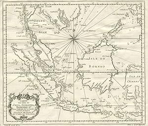
Carte Des Isles de Java, Sumatra, Borneo & Les Detroits de la Sonde Malaca et Banca
Published by Bellini, 1760
Map
Sin Encuadernar. Condition: Muy bien. Detailed map of the Malaysian peninsula, Borneo and Indonesia, from L'Histoire Generale des Voyages. With title cartouche at lower left and great detail on the Indonesian islands, including the names of cities and harbors. At bottom left corner "Tome II in 4, no. 2; at the lower right "Tome 4 in 8. Page 132". Uncolored, with compass rose.
-

Les Isles de la Sonde entre les quelles sont Sumatra, Java, Borneo
Published by Paris, 1660
Seller: Alexandre Antique Prints, Maps & Books, Toronto, ON, Canada
Seller rating 5 out of 5 stars
Map
Condition: Excellent. French map of South East Asia., Size : 195x250 (mm), 7.625x9.875 (Inches), Hand Colored.
-
Carte Des Isles de Java, Sumatra, Borneo & Les Detroits de la Sonde Malaca et Banca
Published by Chez Didot, Paris, 1760
Seller: Antipodean Books, Maps & Prints, ABAA, Garrison, NY, U.S.A.
Association Member: ABAA ANZAAB ESA ILAB
Seller rating 4 out of 5 stars

First Edition
Condition: Very good condition. First printing. Detailed map of the Malaysian peninsula, Borneo and Indonesia, from L'Histoire Generale des Voyages. With title cartouche at lower left and great detail on the Indonesian islands, including the names of cities and harbors. At bottom left corner "Tome II in 4, no. 2; at the lower right "Tome 4 in 8. Page 132". Uncolored, with compass rose. Size: 11 3/4 x 10", with wide margins. Strong impression, very clean.
-

1 carte en couleurs des Isles de la Sonde, de format 26*21 cm ($0*31 cm sous marie-louise, parfait �tat. Copper engraved double page, hand colored in outline, with decorative cartouche. Covers Indonesia and the area from the Malay Peninsula and Borneo in the north to Java and the Sonda Straits in the south. Showing boundaries, major cities, towns, villages, rivers, mountains, drainage, etc. Relief shown pictorially.
-

"Isles de la Sonde vers l'Occident" - Sumatra island Borneo Java Malaysia Indonesia Asia map Karte
Language: German
Published by Frankfurt, 1719
Seller: Antiquariat Steffen V�lkel GmbH, Seubersdorf, Germany
Seller rating 5 out of 5 stars
Map
Original Kupferstich von Alain Manesson Mallet (1630-1706). -- Blatt-Ma�e: ca. 20 x 15 cm -- gut erhalten. || Original copper engraving by Alain Manesson Mallet (1630-1706) . -- in good condition. // Wir, das Antiquariat Steffen V�lkel, kaufen und verkaufen alte B�cher, Handschriften, Zeichnungen, Autographen, Grafiken und Fotografien. Wir sind stets am Ankauf von kompletten Bibliotheken, Sammlungen und Nachl�ssen interessiert. Sprache: Deutsch Gewicht in Gramm: 10.
-

"Isles de la Sonde vers l'Occident" - Sumatra island Borneo Java Malaysia Indonesia Asia map Karte
Language: German
Published by Frankfurt, 1719
Seller: Antiquariat Steffen V�lkel GmbH, Seubersdorf, Germany
Seller rating 5 out of 5 stars
Map
Original Kupferstich von Alain Manesson Mallet (1630-1706). -- Blatt-Ma�e: ca. 20 x 15 cm. -- im Au�enrand leicht fleckig, sonst gut erhalten. || Original copper engraving by Alain Manesson Mallet (1630-1706) . -- slightly stained on the outer margin, otherwise in good condition. // Wir, das Antiquariat Steffen V�lkel, kaufen und verkaufen alte B�cher, Handschriften, Zeichnungen, Autographen, Grafiken und Fotografien. Wir sind stets am Ankauf von kompletten Bibliotheken, Sammlungen und Nachl�ssen interessiert. Sprache: Deutsch Gewicht in Gramm: 10.
-

Carte des Isles de Java, Sumatra, Borneo et les detroits de la Sonde Malaca et Banca Golphe de Siam.
Publication Date: 1780
Seller: Geographicus Rare Antique Maps, Brooklyn, NY, U.S.A.
Association Member: ABAA ESA ILAB
Seller rating 3 out of 5 stars

Map
Very good. Even overall toning. Exhibits light offsetting. Blank on verso. Size 10.5 x 11.5 Inches. This is an attractive c.1780 Jacques Nicholas Bellin map of the East Indies. The map depicts from Siam (Thailand) and Tsiompa (modern day Vietnam) south to include the Sumatra, Java, and Borneo. The Malay Peninsula (Malacca), Singapore, Borneo, Sumatra, Java, and part of Celebes (Sulawesi), are included. Impressive detail appears along all the coastlines, however little inland information is present, as is common for Bellin's nautical charts. Singapore remains unidentified, but several other lesser islands are noted including Tioman Island (Poulo ou I. Timon) and Penang. A beautifully engraved rocco title cartouche adorns the lower left corner of the map. Publication History and Census This map was created by Jacques Nicholas Bellin and published in 1780 by De la Harpe in his Abr�g� de l'Historie g�n�rale des Voyages . Four examples are cataloged in OCLC and are part of the institutional collections at Cornell University, the University of Hawaii, the Bayerische Staatsbibliothek in Munich, and the Unversit�tsbibliothek M�nchen in Munich. References: OCLC 163338680.
-

Carte des Isles de Java, Sumatra, Borneo & les detroits de la Sonde Malaca et Banca Golphe de Siam.
Publication Date: 1750
Seller: Geographicus Rare Antique Maps, Brooklyn, NY, U.S.A.
Association Member: ABAA ESA ILAB
Seller rating 4 out of 5 stars
Map
Very good. Minor wear along original fold lines. Minor spotting. Top margin extended. Size 10 x 12 Inches. This is an attractive c.1750 map of the East Indies by Jacques Nicholas Bellin. The map covers from Siam (Thailand) and Tsiompa (modern day Vietnam) south to include the Sumatra, Java, and Borneo. The Malay (Malacca), Singapore, Borneo, Sumatra, Java, and part of Celebes (Sulawesi), are also included. There is impressive detail throughout the coastline, with little inland information, as is common for Bellin's nautical charts. Singapore remains unidentified, but several other lesser islands are noted including Tioman Island (Poulo ou I. Timon) and Penang. A beautifully engraved rocco title cartouche adorns the lower left corner of the map. This map was issued in Antoine-Francois Prevost's Historie General des voyages . References: OCLC: 220972306.
-

Carte Des Isles de Java, Sumatra Borneo & Les D�troits de la Sonde Malaca et Banca Golphe de Siam & Par N. Bellin Ingr. de la Marine.
Publication Date: 1755
Seller: Antiquariaat Dat Narrenschip, Middelburg, Netherlands
Seller rating 5 out of 5 stars
Map
No Binding. Condition: Good. Antique map of most of Indonesia and Malaysia. Title cartouche bottom left. Backside blank. Hand-coloured copper engraving, published around 1755 in Paris in "L'Histoire g�n�rale des voyages," Antoine Fran�ois Pr�vost. Cartographer: Jacques Nicolas Bellin. Dimensions (image): 25 x 29 cm.

