Order Total (1 Item Items):
Shipping Destination:

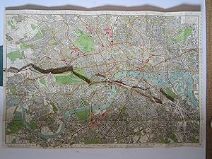
Indicator Map London Divided Quarter by C Smith (1 results)
Skip to main search results
Search filters
Product Type
- All Product Types
- Books (No further results match this refinement)
- Magazines & Periodicals (No further results match this refinement)
- Comics (No further results match this refinement)
- Sheet Music (No further results match this refinement)
- Art, Prints & Posters (No further results match this refinement)
- Photographs (No further results match this refinement)
- Maps (1)
- Manuscripts & Paper Collectibles (No further results match this refinement)
Condition Learn more
- New (No further results match this refinement)
- As New, Fine or Near Fine (No further results match this refinement)
- Very Good or Good (1)
- Fair or Poor (No further results match this refinement)
- As Described (No further results match this refinement)
Binding
- All Bindings
- Hardcover (No further results match this refinement)
- Softcover (1)
Collectible Attributes
- First Edition (No further results match this refinement)
- Signed (No further results match this refinement)
- Dust Jacket (No further results match this refinement)
- Seller-Supplied Images (1)
- Not Print on Demand (1)
Language (1)
Price
- Any Price
- Under � 20 (No further results match this refinement)
- � 20 to � 35 (No further results match this refinement)
- Over � 35
Free Shipping
- Free Shipping to U.S.A. (No further results match this refinement)
Seller Location
Seller Rating
-
Indicator map of London divided into Quarter Mile Squares for Measuring Distances
Published by C.Smith & Son, London, 1900
Seller: Angelika C. J. Friebe Ltd. - MapWoman, Dorking, United Kingdom
Seller rating 4 out of 5 stars

Map
Soft cover. Condition: Very Good. colour printed map pasted on cloth with attached cloth tape measure, inserted in teal cloth binding, with street index (detached from cover). map: overall 60 x 99 cm. cover: 17,5 x 11,5 cm. map in vg cond with some very small tears in cross folds; binding some wear and tear to spine, and some discolouration; o/w g cond. Some damage to the index booklet.- This 'novelty' map of London stretches from Kentish Town to Clapham Common, and from Wormwood Scrubs east to the Isle of Dogs, showing the Underground and Electric Railways as well as bus and tram routes. It has an attached numbered tape measure with a short explanation of how to use it at the lower margin of the map. The included 73 pp street index provides the coordinates for streets as well as public places.