India by Society Diffusion Useful Knowledge (22 results)
 More images
Published by London, 1831
Seller: Bolivar Old Prints Anticuario, Barcelona, B, SpainBolivar Old Prints Anticuario
Contact seller5-star sellerCondition: Used - Very good
£ 74.62
£ 21.31 shippingShips from Spain to U.S.A.Quantity: 1 available
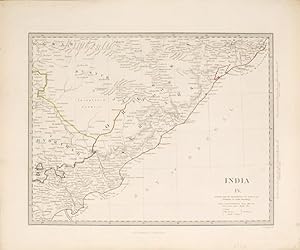
Add to basketCondition: Very Good. [Descripción en español a continuación] Original antique map of the Madras Presidency, in southern India, produced by the Society for the Diffusion of Useful Knowledge and published in London in 1831. This map covers the present-day states of Karnataka and Andhra Pradesh, as well as the northern part of Tam…il Nadu. Among the cities depicted are Chennai (then called Madras), Bangalore, Mysore, Goa and Coimbatore. The Madras Presidency was one of the three principal administrative divisions of British India during the colonial period. The Society for the Diffusion of Useful Knowledge was a British organisation founded in 1826 with the aim of spreading scientific and geographical knowledge among the general public through accessible and low-cost publications. Copperplate engraving. -------------------- Mapa antiguo original de la Presidencia de Madrás, en el sur de la India, elaborado por la Society for the Diffusion of Useful Knowledge y editado en Londres en 1831. Este mapa cubre los actuales estados de Karnataka y Andhra Pradesh, así como la parte norte de Tamil Nadu. Entre las ciudades representadas figuran Chennai (entonces llamada Madras), Bengalore, Mysore, Goa y Coimbatore. La Presidencia de Madrás era una de las tres principales divisiones administrativas de la India británica durante el período colonial. La Society for the Diffusion of Useful Knowledge fue una organización británica fundada en 1826 con el objetivo de difundir conocimientos científicos y geográficos entre el público general mediante publicaciones accesibles y a bajo coste. Grabado en cobre.
Published by London. c.1847, 1847
Seller: Peter Harrington. ABA/ ILAB., London, United KingdomPeter Harrington. ABA/ ILAB.
Contact seller5-star sellerCondition: Used
£ 75.00
£ 22.00 shippingShips from United Kingdom to U.S.A.Quantity: 1 available
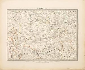
Add to basketA splendidly informative map of the north-central part of India, extending from Gulf of Cambay, current Gulf of Khambhat in the west to Nagpoor in the east. Published by Charles Knight for the S.D.U.K. Size: 352 x 430 mm. Steel engraving with original outline colour. Good condition.
Published by London. c.1847, 1847
Seller: Peter Harrington. ABA/ ILAB., London, United KingdomPeter Harrington. ABA/ ILAB.
Contact seller5-star sellerCondition: Used
£ 75.00
£ 22.00 shippingShips from United Kingdom to U.S.A.Quantity: 1 available
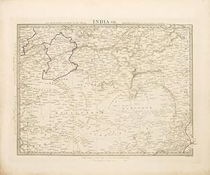
Add to basketA splendidly informative map of Orissa on the Bengal Bay, showing the Rajahs of Rewah and Berar. Published by Charles Knight for the S.D.U.K. Size: 352 x 430 mm. Steel engraving with original outline colour. Good condition.
Published by London. c.1847, 1847
Seller: Peter Harrington. ABA/ ILAB., London, United KingdomPeter Harrington. ABA/ ILAB.
Contact seller5-star sellerCondition: Used
£ 75.00
£ 22.00 shippingShips from United Kingdom to U.S.A.Quantity: 1 available
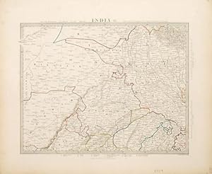
Add to basketA splendidly informative and detailed map of Delhi and the country around it. Published by Charles Knight for the S.D.U.K. Size: 352 x 430 mm. Steel engraving with original outline colour. Good condition.
Published by London. c.1847, 1847
Seller: Peter Harrington. ABA/ ILAB., London, United KingdomPeter Harrington. ABA/ ILAB.
Contact seller5-star sellerCondition: Used
£ 75.00
£ 22.00 shippingShips from United Kingdom to U.S.A.Quantity: 1 available
Add to basketA splendidly informative map of the Eastern coast of Orissa on the Bay of Bengal. Published by Charles Knight for the S.D.U.K. Size: 352 x 430 mm. Steel engraving with original outline colour. Good condition.

Seller: Art Source International Inc., Boulder, CO, U.S.A.Art Source International Inc.
Contact seller5-star sellerThis finely detailed map was published in 1844 by the Society for the Diffusion of Useful Knowledge, a British philanthropical group. Cities, towns, regions, rivers and mountain ranges are illustrated. Copper plate engraved with original hand outline coloring. This map measures 13.5 inches by 10.5 inches.

Seller: Art Source International Inc., Boulder, CO, U.S.A.Art Source International Inc.
Contact seller5-star sellerThis finely detailed map was published in 1844 by the Society for the Diffusion of Useful Knowledge, a British philanthropical group. Cities, towns, regions, rivers and mountain ranges are illustrated. Copper plate engraved with original hand outline coloring. This map measures 14 inches by 10.25 inches.

Seller: Art Source International Inc., Boulder, CO, U.S.A.Art Source International Inc.
Contact seller5-star sellerThis finely detailed map was published in 1844 by the Society for the Diffusion of Useful Knowledge, a British philanthropical group. Cities, towns, regions, rivers and mountain ranges are illustrated. Copper plate engraved with original hand outline coloring. This map measures 15.5 inches by 12.5 inches.

Seller: Art Source International Inc., Boulder, CO, U.S.A.Art Source International Inc.
Contact seller5-star sellerThis finely detailed map was published in 1844 by the Society for the Diffusion of Useful Knowledge, a British philanthropical group. Cities, towns, regions, rivers and mountain ranges are illustrated. Copper plate engraved with original hand outline coloring. This map measures 12.5 inches by 15.5 inches.

Published by London. c.1847, 1847
Seller: Peter Harrington. ABA/ ILAB., London, United KingdomPeter Harrington. ABA/ ILAB.
Contact seller5-star sellerCondition: Used
£ 145.00
£ 22.00 shippingShips from United Kingdom to U.S.A.Quantity: 1 available
Add to basketA splendidly informative map of North India and Nepal, the Himalayan Mountains and Chinese Tartary. Published by Charles Knight for the S.D.U.K. Size: 352 x 430 mm. Steel engraving with original outline colour. Good condition.

Published by London, 1857
- Art / Print / Poster
Seller: Trillium Antique Prints & Rare Books, Franklin, TN, U.S.A.Trillium Antique Prints & Rare Books
Contact seller3-star sellerCondition: Fine. This originally hand-colored engraving is from "The Complete Atlas of Modern, Classical and Celestial Maps, together with Plans of the Principal Cities of the World". The work was published in 1857 by Edward Stanford for the Society for the Diffusion of Useful Knowledge. --- The work is in very good to excellent… condition. There may be a few minor imperfections to be expected with age. Please review the image carefully for condition and contact us with any questions. --- Paper Size ~ 14" by 16 7/8".

Map of the Antilles or West India Islands (West Indies)
Edward Stanford for the Society for the Diffusion of Useful Knowledge
Published by London, 1857
- Art / Print / Poster
Seller: Trillium Antique Prints & Rare Books, Franklin, TN, U.S.A.Trillium Antique Prints & Rare Books
Contact seller3-star sellerCondition: Fine. This originally hand-colored engraving is from "The Complete Atlas of Modern, Classical and Celestial Maps, together with Plans of the Principal Cities of the World". The work was published in 1857 by Edward Stanford for the Society for the Diffusion of Useful Knowledge. --- The work is in very good to excellent… condition. There may be a few minor imperfections to be expected with age. Please review the image carefully for condition and contact us with any questions. --- Paper Size ~ 14" by 16 7/8".

Seller: Art Source International Inc., Boulder, CO, U.S.A.Art Source International Inc.
Contact seller5-star sellerThis finely detailed map was published in 1844 by the Society for the Diffusion of Useful Knowledge, a British philanthropical group. Cities, towns, regions, rivers and mountain ranges are illustrated. Copper plate engraved with original hand outline coloring. This map measures 13.5 inches by 10.5 inches.

Seller: Art Source International Inc., Boulder, CO, U.S.A.Art Source International Inc.
Contact seller5-star sellerThis finely detailed map was published in 1844 by the Society for the Diffusion of Useful Knowledge, a British philanthropical group. Cities, towns, regions, rivers and mountain ranges are illustrated. Copper plate engraved with original hand outline coloring. This map measures 14 inches by 10.5 inches.

Seller: Art Source International Inc., Boulder, CO, U.S.A.Art Source International Inc.
Contact seller5-star sellerThis finely detailed map was published in 1844 by the Society for the Diffusion of Useful Knowledge, a British philanthropical group. Cities, towns, regions, rivers and mountain ranges are illustrated. Copper plate engraved with original hand outline coloring. This map measures 13.5 inches by 10.75 inches.

Seller: Art Source International Inc., Boulder, CO, U.S.A.Art Source International Inc.
Contact seller5-star sellerThis finely detailed map was published in 1844 by the Society for the Diffusion of Useful Knowledge, a British philanthropical group. Cities, towns, regions, rivers and mountain ranges are illustrated. Copper plate engraved with original hand outline coloring. This map measures 14 inches by 10.5 inches.

Seller: Art Source International Inc., Boulder, CO, U.S.A.Art Source International Inc.
Contact seller5-star sellerThis finely detailed map was published in 1833 by the Society for the Diffusion of Useful Knowledge, a British philanthropical group. Cities, towns, regions, rivers and mountain ranges are illustrated. Copper plate engraved with original hand outline coloring. This map measures 15.5 inches by 12.5 inches.

Seller: Art Source International Inc., Boulder, CO, U.S.A.Art Source International Inc.
Contact seller5-star sellerThis finely detailed map was published in 1832 by the Society for the Diffusion of Useful Knowledge, a British philanthropical group. Cities, towns, regions, rivers and mountain ranges are illustrated. Copper plate engraved with original hand outline coloring. This map measures 15.5 inches by 12.5 inches.

Seller: Art Source International Inc., Boulder, CO, U.S.A.Art Source International Inc.
Contact seller5-star sellerThis finely detailed map was published in 1831 by the Society for the Diffusion of Useful Knowledge, a British philanthropical group. Cities, towns, regions, rivers and mountain ranges are illustrated. Copper plate engraved with original hand outline coloring. This map measures 15.5 inches by 12.5 inches.

Seller: Art Source International Inc., Boulder, CO, U.S.A.Art Source International Inc.
Contact seller5-star sellerThis finely detailed map was published in 1844 by the Society for the Diffusion of Useful Knowledge, a British philanthropic group. Cities, towns, regions, rivers and mountain ranges are illustrated. Copper plate engraved with original hand outline coloring. This map measures 10.25 inches by 11 inches.

Seller: Art Source International Inc., Boulder, CO, U.S.A.Art Source International Inc.
Contact seller5-star sellerThis finely detailed map was published in 1844 by the Society for the Diffusion of Useful Knowledge, a British philanthropical group. Cities, towns, regions, rivers and mountain ranges are illustrated. Copper plate engraved with original hand outline coloring. This map measures 12.5 inches by 15.5 inches.


