Order Total (1 Item Items):
Shipping Destination:

Hull by Bartholomew (5 results)
Skip to main search results
Search filters
Product Type
- All Product Types
- Books (1)
- Magazines & Periodicals (No further results match this refinement)
- Comics (No further results match this refinement)
- Sheet Music (No further results match this refinement)
- Art, Prints & Posters (No further results match this refinement)
- Photographs (No further results match this refinement)
- Maps (4)
- Manuscripts & Paper Collectibles (No further results match this refinement)
Condition Learn more
- New (No further results match this refinement)
- As New, Fine or Near Fine (No further results match this refinement)
- Very Good or Good (1)
- Fair or Poor (No further results match this refinement)
- As Described (4)
Binding
- All Bindings
- Hardcover (No further results match this refinement)
- Softcover (3)
Collectible Attributes
- First Edition (3)
- Signed (No further results match this refinement)
- Dust Jacket (No further results match this refinement)
- Seller-Supplied Images (5)
- Not Print on Demand (5)
Language (1)
Free Shipping
- Free Shipping to U.S.A. (No further results match this refinement)
Seller Location
Seller Rating
-

Single sheet. Detailed plan of the streets of the centre showing the Docks, 4 stations, tram tracks, Hymers College and the work house. Narrow top margin. 32 x 21 cm.
-
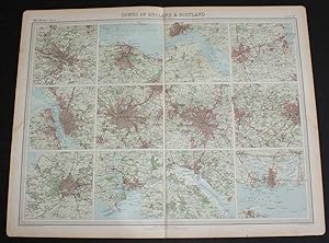
Softcover. Condition: Very Good. Dust Jacket Condition: No Dust Jacket. First Edition. Disbound single sheet with vertical centre fold from the 1920 "The Times Survey Atlas of the World". Sheet is divided into 12 small plans. Map is in colour and suitable for framing. Map at scale 1:126,720. Settlements are shaded pink and street layouts are clearly visible. Parks are in green and water is blue. Plans include: Glasgow; Edinburgh and Leith; Hull and Hedon; Newcastle, Gateshead, Tynemouth, South Shields and Jarrow; Liverpool and Birkenhead; Manchester and Salford; Birmingham and West Bromwich; Bradford and Leeds; Bristol and Clifton; Plymouth, Saltash and Devonport; Southampton; and Portsmouth and Ryde. Slightly darkened and worn edges with occasional foxing in the margins. Very small nick to bottom edge of margin near bottom right corner, sheet is otherwise crisp, clean and bright. Size: 46 x 58cm approx. Quantity Available: 1. Shipped Weight: under 1 kg. Pictures of this item not already displayed here available upon request. Inventory No: 45020044019. All our books are sent by tracked mail.
-

Hull
Published by published by A Fullarton & Co [1860], London, 1860
Seller: Keoghs Books, Skipton, United Kingdom
Association Member: PBFA
Seller rating 5 out of 5 stars

Map First Edition
, paper map coloured in outline, upper left corner Hull Cemetery, upper right corner Hornsea Railway, Lower Left Hull & Selby railway, River Humber at bottom First Edition thus , some light spots but generally clean, in very good condition 27 x 18 cm Paperback ISBN:
-

Hull
Published by published by A Fullarton & Co [1860], London, 1860
Seller: Keoghs Books, Skipton, United Kingdom
Association Member: PBFA
Seller rating 5 out of 5 stars
Map First Edition
, paper map coloured in outline, upper left corner Hull Cemetery, upper right corner Hornsea Railway, Lower Left Hull & Selby railway, River Humber at bottom First Edition thus , some light spots but generally clean, in very good condition 27 x 18 cm Paperback ISBN:
-

Plans of Newcastle, Hull, Bradford and Leeds.
Published by The Edinburgh Geographical Institute ., 1903
Seller: Robert Frew Ltd. ABA ILAB, London, United Kingdom
Association Member: ABA ILAB PBFA
Seller rating 5 out of 5 stars
Map
A large colour printed lithographic map of the northern cities of Newcastle, Hull, Bradford and Leeds (size 53.5 x 41.5 cm overall 59.5 x 45 cm) all shown in great detail. Local areas are named, railways lines are shown, as are public parks, fields and cemeteries. Mileage scale for each. In excellent condition. Atlas of England & Wales Plate 82.