
Order Total (1 Item Items):
Shipping Destination:

Geographical Statistical Historical Upper by Map (1 results)
Skip to main search results
Search filters
Product Type
- All Product Types
- Books (No further results match this refinement)
- Magazines & Periodicals (No further results match this refinement)
- Comics (No further results match this refinement)
- Sheet Music (No further results match this refinement)
- Art, Prints & Posters (No further results match this refinement)
- Photographs (No further results match this refinement)
- Maps (1)
- Manuscripts & Paper Collectibles (No further results match this refinement)
Condition Learn more
- New (No further results match this refinement)
- As New, Fine or Near Fine (No further results match this refinement)
- Very Good or Good (1)
- Fair or Poor (No further results match this refinement)
- As Described (No further results match this refinement)
Binding
- All Bindings
- Hardcover (No further results match this refinement)
- Softcover (No further results match this refinement)
Collectible Attributes
- First Edition (No further results match this refinement)
- Signed (No further results match this refinement)
- Dust Jacket (No further results match this refinement)
- Seller-Supplied Images (1)
- Not Print on Demand (1)
Language (1)
Price
- Any Price
- Under � 20 (No further results match this refinement)
- � 20 to � 35 (No further results match this refinement)
- Over � 35
Free Shipping
- Free Shipping to U.S.A. (No further results match this refinement)
Seller Location
Seller Rating
-
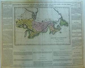
Geographical, Statistical, And Historical Map Of Upper And Lower Canada And The Other British Possessions In North America
Published by Young & Delleker, London, 1822
Map
Map. Condition: Very Good+. A visually striking and interesting early hand-colored map depicting British possessions in North America from Hudson's Bay in the north to Lake Erie in the south, and Lake of the Woods, northwest of Lake Superior in the west, to Newfoundland in the east. It includes: Upper and Lower Canada, the Great Lakes, Michigan, Northwest Territories, Hudson's Bay, New South Wales, Newfoundland, Labrador, Maine, Canada, etc. Since the map includes the entire great lakes system, the lower peninsula of Michigan is also included. The map measures 9 1/2" x 14" and was engraved by Young & Delleker. The sheet also provides textual descriptions of British Possessions in North America: Lower and Upper Canada, Nova Scotia and New Brunswick. This is a striking map with interesting geographical information contained in the text. The entire sheet measures 16 1/2" x 20 3/4" The map is also titled "British Possessions in North America". Scale is about 35 miles per inch. The latest date in the text is 1821. Identified as map No. 4. Which was originally bound in an atlas: "A Complete Historical, Chronological, and Geographical Atlas, Being A Guide to the History of North and South America, and the West Indies." The map has a single fold down center, as issued. It was drawn by F. Lucas, Jr. Ref: Does not appear to be in Karpinski ; Hand Colored Map; 21 5/8" x 17 1/2".