
Order Total (1 Item Items):
Shipping Destination:

General Topographical Map Sheet by Julius (3 results)
Skip to main search results
Search filters
Product Type
- All Product Types
- Books (3)
- Magazines & Periodicals (No further results match this refinement)
- Comics (No further results match this refinement)
- Sheet Music (No further results match this refinement)
- Art, Prints & Posters (No further results match this refinement)
- Photographs (No further results match this refinement)
- Maps (No further results match this refinement)
- Manuscripts & Paper Collectibles (No further results match this refinement)
Condition Learn more
- New (No further results match this refinement)
- As New, Fine or Near Fine (No further results match this refinement)
- Very Good or Good (No further results match this refinement)
- Fair or Poor (No further results match this refinement)
- As Described (3)
Binding
- All Bindings
- Hardcover (No further results match this refinement)
- Softcover (No further results match this refinement)
Collectible Attributes
- First Edition (No further results match this refinement)
- Signed (No further results match this refinement)
- Dust Jacket (No further results match this refinement)
- Seller-Supplied Images (3)
- Not Print on Demand (3)
Language (1)
Price
- Any Price
- Under � 20 (No further results match this refinement)
- � 20 to � 35 (No further results match this refinement)
- Over � 35
Free Shipping
- Free Shipping to U.S.A. (No further results match this refinement)
Seller Location
Seller Rating
-

General Topographical Map, Sheet XI
Published by Julius Bien & Co, New York, 1895
Seller: Argosy Book Store, ABAA, ILAB, New York, NY, U.S.A.
Seller rating 5 out of 5 stars

unbound. Map. Color lithograph. Sheet measures 18 1/2" x 29 1/2" This map appeared as Plate CXLVI in "The Atlas to Accompany the Official Records of the Union and Confederate Armies, 1861-1865. Northern and central Florida are displayed, extending as far north as Jacksonville and as far south as Clearwater Harbor. An inset map of southern Florida is included in the lower left corner. The map is highly detailed, with cities, rivers, towns, post offices, villages, railroads, vegetation and forts labeled. Swamps are depicted pictorially, and relief is shown by hachure. Florida was a vital source of beef and salt for the Confederacy. Florida beef became especially important after the Confederates lost control of the Mississippi River in 1864. With the flow of beef from Texas almost completely cut off, Florida%u2019s vast supply of cattle became a critical food source for the Confederate Army.Folded as issued. This map wonderful piece that boldly documents American history. Julius Bien (1826-1909) was an American lithographic printer and cartographer based in New York City. During the course of the second half of the 19th century, he produced thousands of maps for both public and private publishers. Some of his most notable commissions were for the U.S. government, including many geological maps that redefined the cartographic visualization of geology. Bien's prolific output and contributions to the development of chromo-lithography make him one of the most significant map printers of his time. This is a great example of his fine work.
-
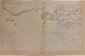
General Topographical Map, Sheet XXIV
Published by Julius Bien & Co, New York, 1895
Seller: Argosy Book Store, ABAA, ILAB, New York, NY, U.S.A.
Seller rating 5 out of 5 stars
unbound. Map. Color lithograph. Sheet measures 18 1/2" x 29 1/2" This map appeared as Plate CLX in "The Atlas to Accompany the Official Records of the Union and Confederate Armies, 1861-1865." It depicts the border region of Oklahoma (Indian Territory), Arkansas, and Texas. The area labeled as Indian Territory is subdivided by nation - showing Cherokee, Creek, Quapaws, Senecas and Shawnees, and Senecas Proper. The map is highly detailed, with cities, rivers, towns, post offices, villages, railroads, and forts labeled. Swamps are depicted pictorially, and relief is shown by hachure. Map is in excellent condition. Folded as issued.This map wonderful piece that boldly documents American history. Julius Bien (1826-1909) was an American lithographic printer and cartographer based in New York City. During the course of the second half of the 19th century, he produced thousands of maps for both public and private publishers. Some of his most notable commissions were for the U.S. government, including many geological maps that redefined the cartographic visualization of geology. Bien's prolific output and contributions to the development of chromo-lithography make him one of the most significant map printers of his time. This is a great example of his fine work.
-
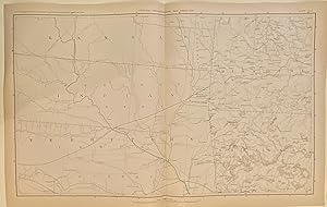
General Topographical Map, Sheet XXV
Published by Julius Bien & Co, New York, 1895
Seller: Argosy Book Store, ABAA, ILAB, New York, NY, U.S.A.
Seller rating 5 out of 5 stars
unbound. Map. Color lithograph. Sheet measures 18 1/2" x 29 1/2" This map appeared as Plate CLX in "The Atlas to Accompany the Official Records of the Union and Confederate Armies, 1861-1865." It depicts the region where Kansas, Missouri, Arkansas, and Oklahoma (Indian Territory) meet. The area labeled as Indian Territory is subdivided by nation - showing Cherokee, Creek, Quapaws, Senecas and Shawnees, and Senecas Proper. The map is highly detailed, with railroads, canals, towns, post offices, villages, and forts labeled. Swamps are depicted pictorially, and relief is shown by hachure. In very good condition, with minor chips and tears at margins. Folded as issued. This map wonderful piece that boldly documents American history. Julius Bien (1826-1909) was an American lithographic printer and cartographer based in New York City. During the course of the second half of the 19th century, he produced thousands of maps for both public and private publishers. Some of his most notable commissions were for the U.S. government, including many geological maps that redefined the cartographic visualization of geology. Bien's prolific output and contributions to the development of chromo-lithography make him one of the most significant map printers of his time. This is a great example of his fine work.