
Order Total (1 Item Items):
Shipping Destination:

France by Augustus Mitchell (30 results)
Skip to main search results
Search filters
Product Type
- All Product Types
- Books (26)
- Magazines & Periodicals (No further results match this refinement)
- Comics (No further results match this refinement)
- Sheet Music (No further results match this refinement)
- Art, Prints & Posters (2)
- Photographs (No further results match this refinement)
- Maps (1)
- Manuscripts & Paper Collectibles (1)
Condition Learn more
- New (No further results match this refinement)
- As New, Fine or Near Fine (1)
- Very Good or Good (5)
- Fair or Poor (No further results match this refinement)
- As Described (24)
Binding
- All Bindings
- Hardcover (No further results match this refinement)
- Softcover (No further results match this refinement)
Collectible Attributes
- First Edition (1)
- Signed (No further results match this refinement)
- Dust Jacket (No further results match this refinement)
- Seller-Supplied Images (27)
- Not Print on Demand (30)
Language (2)
Free Shipping
Seller Location
Seller Rating
-
![Seller image for [Map] France [with insets] Environs of Paris [and] Switzerland in Cantons [and] Corsica for sale by Kaaterskill Books, ABAA/ILAB](https://pictures.abebooks.com/inventory/md/md31156942303.jpg)
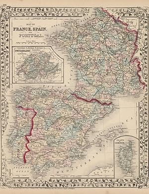
[Map] France [with insets] Environs of Paris [and] Switzerland in Cantons [and] Corsica
Language: English
Published by [W.M. Bradley & Bro.], [Philadelphia], 1886
Seller: Kaaterskill Books, ABAA/ILAB, East Jewett, NY, U.S.A.
Association Member: ABAA ILAB IOBA
Seller rating 5 out of 5 stars

Hand colored map. 15 x 11.5 inches. Plate 110. France, with insets of Environs of Paris ; Switzerland in cantons; and Corsica. Copyright by S. Augustus Mitchell 1884 From: Mitchell's New General Atlas, Containing Maps Of The Various Countries Of The World, Plans Of Cities, Etc., Embraced In Ninety-Three Quarto Maps, Forming A Series Of One Hundred and Forty-seven Maps and Plans, Together With Valuable Statistical Tables. Also, A List Of Post-Offices Of The United States And Territories, And Also Census Of 1880 For States, Territories And Counties, Also Of Cities Of Over 10,000 Inhabitants. Philadelphia: Published By Wm. M. Bradley & Bro., No. 1026 Arch Street. 1886. Very good, closely cropped margins, light soiling.
-

Map of France from Mitchell's Universal Atlas. fine condition. Full color by department. 2 inset maps, of Corsica and the Environs of Paris. There is no imprint or copyright line, but this is removed from one of the latest issues of this atlas before publication was taken up by Thomas, Cowperthwait & Co. Map no. 49.
-

13 1/4 x 11 1/2 inches. Condition: Very good condition. Very nice map of the three countries with an inset of the Cantons of Switzerland.The map was printed in black and hand coloring was applied at the time of publication.
-

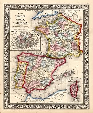
France, Spain, Portugal Map.
Published by Philadelphia, Pa.: S. Augustus Mitchell., 1860
Seller: Wittenborn Art Books, San Francisco, CA, U.S.A.
Seller rating 5 out of 5 stars
Art / Print / Poster
Condition: Good. Map. Engraved. Colored. 13 x 11 inches. Inset of Swltzerland In Cantons.
-

Map of France, Spain and Portugal.
Published by Philadelphia:, 1861
Seller: Nicholas D. Riccio Rare Books, ABAA, Florham Park, NJ, U.S.A.
Seller rating 4 out of 5 stars

Map of France Spain, and Portugal. Philadelphia: 1861. Unbound, colored engraved map, decorative border, 14" x 11". Slight browning and aging, some chips and nicks at the left edge; overall bright and clean and in very good condition. Maps are wrapped with acid free board, or in rigid sleeves. The Mitchell family started to produce atlases in 1846, and continued into the early 1890s. Around 1860, S. Augustus Mitchell Jr. took over, and the atlas would be called Mitchell's New General Atlas. This is a very colorful map of France, Spain and Portugal from the 1864 installment of that atlas. An inset illustrates Switzerland and the Island of Corsica. Extra postage may be required. Ristow 311-313.
-
Map of France Spain, and Portugal.
Published by Philadelphia, 1882
Seller: Nicholas D. Riccio Rare Books, ABAA, Florham Park, NJ, U.S.A.
Seller rating 4 out of 5 stars
Philadelphia, 1882. Unbound, colored engraved map, decorative border, 14"x 11". Slight toning and aging; overall bright and clear and in very good shape. Maps are wrapped with acid free board, or in rigid sleeves. The Mitchell family started to produce atlases in 1846, and continued into the early 1890s. Around 1860, S. Augustus Mitchell Jr. took over, and the atlas would be called Mitchell's New General Atlas. This is a colorful map of France, Spain and Portugal from the 1882 installment of that atlas. An inset illustrates Switzerland and the Island of Corsica. Extra postage may be required. Ristow 311-313.
-
Map of France, Spain and Portugal.
Published by S. Augustus Mitchell,, Philadelphia:, 1870
Seller: Nicholas D. Riccio Rare Books, ABAA, Florham Park, NJ, U.S.A.
Seller rating 4 out of 5 stars
Unbound, colored engraved map, decorative boarder, 14"x 11". Slight toning and aging, some staining and soiling in margins; otherwise bright and clear and in very good shape. Maps are wrapped with acid free board, or in rigid sleeves. The Mitchell family started to produce atlases in 1846, and continued into the early 1890s. Around 1860, S. Augustus Mitchell Jr. took over, and the atlas would be called Mitchell's New General Atlas. This is colorful attractive map of France, Spain and Portugal from the 1869 installment of that atlas. Nicely presented color and detail. Ristow 311-313 Phillips 907.
-

Map of France Spain, and Portugal.
Published by Philadelphia:, 1864
Seller: Nicholas D. Riccio Rare Books, ABAA, Florham Park, NJ, U.S.A.
Seller rating 4 out of 5 stars
Unbound, colored engraved map, decorative border, 14" x 11". Slight toning and aging; overall bright and clean and in very good condition. Maps are wrapped with acid free board, or in rigid sleeves. The Mitchell family started to produce atlases in 1846, and continued into the early 1890s. Around 1860, S. Augustus Mitchell Jr. took over, and the atlas would be called Mitchell's New General Atlas. This is a very colorful map of France, Spain and Portugal from the 1864 installment of that atlas. An inset illustrates Switzerland and the Island of Corsica. Extra postage may be required. Ristow 311-313.
-

Mitchell's 1865 Map of France, Spain, and Portugal
Publication Date: 1865
Seller: Art Source International Inc., Boulder, CO, U.S.A.
Seller rating 5 out of 5 stars
In 1860 S. Augustus Mitchell Jr. took over his father's map publishing business and in that year he started publishing Mitchell's New General Atlas. Editions of the new general were issued annually until 1887. Mitchell Jr. continued publishing this atlas until 1879. The editions from 1880 to 1887 were published by Wm. M. Bradley. This map published in 1865 is a wonderful example of Mitchell's map-making prowess with beautiful original hand-coloring. This map measures 10.5 inches by 13.5 inches.
-

France
Publication Date: 1887
Seller: Art Source International Inc., Boulder, CO, U.S.A.
Seller rating 5 out of 5 stars
This map was made by S. Augustus Mitchell for "Mitchell's New General Atlas" published in 1887. The well maintained maps in this atlas feature Mitchell's characteristic pastel coloring and abundant details of geographical features. France is illustrated on this map. Insets show the environs of Paris, the island of Corsica, and Switzerland in cantons. Details include the names of regions, important towns, rivers, lakes, mountain ranges and railroads. Regions are distinguished by color. These 1887 maps offer a fascinating perspective of areas that have since undergone significant growth and change, in addition to their value as great examples of Mitchell's work. This map measures 15.25 inches by 11.5 inches.
-

Map of France, Spain, and Portugal
Publication Date: 1870
Seller: Art Source International Inc., Boulder, CO, U.S.A.
Seller rating 5 out of 5 stars
S. Augustus Mitchell Jr. made this hand colored map for Mitchells New General Atlas in 1870. France, Spain, and Portugal are illustrated on this map with insets of Switzerland in Cantons and Corsica. Regions are distinguished by bright pastel colors. Lakes, mountains, rivers, important cities and countries are identified. This map measures 11.5 inches by 13.5 inches.
-

Map of France, Spain and Portugal
Publication Date: 1867
Seller: Art Source International Inc., Boulder, CO, U.S.A.
Seller rating 5 out of 5 stars
The Mitchell company was one of the first to try out the new technique of engraving on steel plates, experimenting with steel almost 20 years before the rest of the publishing industry. He was printing with steel in the early 1830s; the general switch to steel was approximately 1850. During the early years of the company, Mitchell published mainly maps and travel guides. In 1860, Mitchell started producing "Mitchell's New General Atlas",and Mitchell Sr. retired and turned the business over to his son of the same name. The New General Atlas was published until 1893. Today Mitchell maps are sought after for their fine engraving, bright coloring, and attention to detail. They are some of the finest maps produced in the 1860's. This map produced in 1867, has Mitchell's unique floral border, and beautiful hand coloring. This map details France, Spain and Portugal. Counties, cities, towns, transportation routes and some topographical features are illustrated. Two inset maps are included showing Switzerland in Cantons and the Island of Corsica. This map measures 13 inches by 10.5 inches.
-

Map of France, Spain, and Portugal
Publication Date: 1864
Seller: Art Source International Inc., Boulder, CO, U.S.A.
Seller rating 5 out of 5 stars
With characteristic floral boarders and beautiful, muted pastel coloring, these 1864 maps are fantastic examples of Mitchells work. Regions, important cities, rivers, lakes, and railroads are identified. France, Spain, and Portual are illustrated on this map with insets showing Switzerland and the Island of Corsica. This map measures 11.25 inches by 13.5 inches.
-

Map of France, Spain, and Portugal / Switzerland in Cantons
Publication Date: 1872
Seller: Art Source International Inc., Boulder, CO, U.S.A.
Seller rating 5 out of 5 stars
S. Augustus Mitchell Jr. made this hand colored map in 1872. France, Spain and Portugal are illustrated on this map. Two inset maps of Switzerland in Cantons and the Island of Corsica are also included. Regions are distinguished by bright pastel colors. Deserts, lakes, mountains, rivers, important cities and countries are identified. A signature Mitchell ornate floral design frames this antique map. This map measures 10.5 inches by 13 inches.
-

France (with inset maps of the Environs of Paris, Switzerland in Cantons, and Corsica)
Publication Date: 1888
Seller: Art Source International Inc., Boulder, CO, U.S.A.
Seller rating 5 out of 5 stars
This map of France (with inset maps of the Environs of Paris, Switzerland in Cantons, and Corsica) was made by S. Augustus Mitchell for "Mitchells New General Atlas" published in 1888, by WM. M. Bradley & Co. The well maintained maps in this atlas feature Mitchell's characteristic pastel coloring and abundant details of geographical features. Details include the names of regions, cities, towns, transportation routes, mountain ranges, rivers and lakes. These 1888 maps offer a fascinating perspective of areas that have since undergone significant growth and change, in addition to their value as great examples of Mitchell's work. This map measures 15 inches by 11.5 inches.
-

Map of France, Spain, Portugal & Italy
Publication Date: 1855
Seller: Art Source International Inc., Boulder, CO, U.S.A.
Seller rating 5 out of 5 stars
One of the dominant firms in 19th century cartography was unquestionably the Mitchell publishing company. While they had been producing fine quality maps and atlases since the 1830s, they also made instructional material that was up to date and accurate. This map comes from one of the early school atlases published by Mitchell, and contains a wealth of information, and attractive hand color. The condition is very good, with some mild staining, but mostly outside the image. This map measures 10.5 inches by 8 inches.
-

Map of France, Spain, and Portugal
Publication Date: 1881
Seller: Art Source International Inc., Boulder, CO, U.S.A.
Seller rating 5 out of 5 stars
This map came from Mitchells New General Atlas, 1881. This map shows major railroads, water bodies, and towns. Decorative ivy border, and nice colorful detail. Would look nice framed!' This map measures 11.5 inches by 13.5 inches.
-

Map of France, Spain, and Portugal; Switzerland in Cantons; Island of Corsica
Publication Date: 1879
Seller: Art Source International Inc., Boulder, CO, U.S.A.
Seller rating 5 out of 5 stars
This map of the France, Spain, Portugal, Switzerland, and the Island of Corsica was produced by Augustus Mitchell in 1879 for his New General Atlas. Highlights of this map are Mitchells traditional grapevine border, characteristic pastel coloring and abundant details of geographical features. This 1879 map offers a fascinating perspective of areas that have since undergone significant growth and change, in addition to the value as great examples of Mitchell's classic map-making style. This map measures 11.25 inches by 14 inches.
-

Map of France, Spain, and Portugal
Publication Date: 1868
Seller: Art Source International Inc., Boulder, CO, U.S.A.
Seller rating 5 out of 5 stars
This hand colored map was made for "Mitchells New General Atlas" published by S. Augustus Mitchell, Jr. in 1868. France, Spain, and Portugal are illustrated on this map. Two insets show Switzerland in Cantons, and the Island of Corsica. Provinces are distinguished by color. Other details include the names of counties, and important cities, rivers, lakes, mountains, and railroads. The maps in this atlas have beautiful color- more muted than typical. This map measures 11.5 inches by 13.5 inches.
-
1866 Color Steel Engraved Map of EUROPE France UK Spain Austria Italy TURKEY
Published by Philadelphia : S. Augustus Mitchell, 1866, 1866
No Binding. Condition: Very Good. 1866 Color Steel Engraved Map of EUROPE France UK Spain Austria Italy TURKEY Samuel Augustus Mitchell (1790 1868) was an American geographer. Map maker: Samuel Augustus Mitchell Title: "Map of Europe, showing its Gt. Political divisions." Atlas Title: Mitchell's New General Atlas containing maps of the various countries of the world, plans of cities, etc., embraced in fifty-eight quarto maps, forming a series of ninety-two maps and plans, together with valuable statistical tables. Published: Philadelphia : S. Augustus Mitchell, 1866. FREE SHIPPING WORLDWIDE Wear: wear as seen in photos Publisher: Philadelphia : S. Augustus Mitchell, 1866. Size: ~17.5in X 14in (44.5cm x 35.5cm) Photos available upon request.
-
1866 Color Steel Engraved Map of FRANCE Spain Portugal Corsica Swiss Cantons
Published by Philadelphia : S. Augustus Mitchell, 1866., 1866
No Binding. Condition: Very Good. 1866 Color Steel Engraved Map of FRANCE Spain Portugal Corsica Swiss Cantons Samuel Augustus Mitchell (1790 1868) was an American geographer. Map maker: Samuel Augustus Mitchell Title: "Map of France, Spain, and Portugal." Atlas Title: Mitchell's New General Atlas containing maps of the various countries of the world, plans of cities, etc., embraced in fifty-eight quarto maps, forming a series of ninety-two maps and plans, together with valuable statistical tables. Published: Philadelphia : S. Augustus Mitchell, 1866. FREE SHIPPING WORLDWIDE Wear: wear as seen in photos Publisher: Philadelphia : S. Augustus Mitchell, 1866. Size: ~17.5in X 14in (44.5cm x 35.5cm) Photos available upon request.
-

Map of France, Spain, and Portugal
Publication Date: 1863
Seller: Art Source International Inc., Boulder, CO, U.S.A.
Seller rating 5 out of 5 stars
The Mitchell company was one of the first to try out the new technique of engraving on steel plates, experimenting with steel almost 20 years before the rest of the publishing industry. He was printing with steel in the early 1830s; the general switch to steel engraving was approximately 1850. During the early years of the company, Mitchell published mainly maps and travel guides. In 1860, Mitchell started producing "Mitchell's New General Atlas". Mitchell Sr. retired and turned the business over to his son of the same name. The New General Atlas was published until 1893. Today Mitchell maps are sought after for their fine engraving, bright coloring, and attention to detail. They are some of the finest maps produced in the 1860's. This map, produced in 1863, shows Mitchell's famous flower border, which is only seen in the early editions of his atlases. This map shows France, Spain, and Portugal. This map measures 11 inches by 13.5 inches.
-

France
Publication Date: 1884
Seller: Art Source International Inc., Boulder, CO, U.S.A.
Seller rating 5 out of 5 stars
This map was made by S. Augustus Mitchell for "Mitchells New General Atlas" published in 1884, by WM. M. Bradley & Co. The well maintained maps in this atlas feature Mitchell's characteristic pastel coloring and abundant geographical features. Details include the names of countries, regions, cities, towns, transportation routes, rivers, lakes, and mountain ranges. Regions are distinguished by color. These 1884 maps offer a fascinating perspective of areas that have since undergone significant growth and change, in addition to their value as great examples of Mitchell's work. This map measures 15 inches by 11.5 inches.
-

Map of France, Spain, and Portugal / Switzerland in Cantons
Publication Date: 1874
Seller: Art Source International Inc., Boulder, CO, U.S.A.
Seller rating 5 out of 5 stars
S. Augustus Mitchell Jr. made this hand colored map in 1874. France, Spain and Portugal are illustrated on this map. Two inset maps of Switzerland in Cantons and the Island of Corsica are also included. This map measures 10.5 inches by 13 inches.
-

Map of France, Spain, and Portugal with inset Maps of Switzerland and the Island of Corsica
Publication Date: 1866
Seller: Art Source International Inc., Boulder, CO, U.S.A.
Seller rating 5 out of 5 stars
The Mitchell company was one of the first to try out the new technique of engraving on steel plates experimenting with steel almost 20 years before the rest of the publishing industry. He was printing with steel in the early 1830s; the general switch to steel was approximately 1850. During the early years of the company, Mitchell published mainly maps and travel guides. In 1860, Mitchell started producing "Mitchell's New General Atlas",and Mitchell Sr. retired and turned the business over to his sonof the same name. The New General Atlas was published until1893. Today Mitchell maps are sought after for their fine engraving, bright coloring, and attention to detail. They aresome of the finest maps produced during this time period. This map produced in 1866, has Mitchell's unique floral border, and beautiful hand coloring. This map details France, Spain, and Portugal with inset Maps of Switzerland and the Island of Corsica. Countries, cities, towns, lakes, rivers, mountains, and transportation routes are noted. Each map was printed on thick paper with vibrant hand color. This map measures 11.25 inches by 13.5 inches.
-
Map of France, Spain, and Portugal
Publication Date: 1875
Seller: Art Source International Inc., Boulder, CO, U.S.A.
Seller rating 5 out of 5 stars
This map was produced by S. Augustus Mitchell in 1875 for his New General Atlas. This map shows Mitchells traditional grape vine border, characteristic pastel coloring and abundant details of geographical features. Counties are distinguished by different colors. Wagon trails and major routes of transport are also shown. These 1875 maps offer a fascinating perspective of areas that have since undergone significant growth and change, in addition to their value as great examples of Mitchell's work. This map measures 11 inches by 14 inches.
-

France
Publication Date: 1885
Seller: Art Source International Inc., Boulder, CO, U.S.A.
Seller rating 5 out of 5 stars
This map was made by S. Augustus Mitchell for "Mitchells New General Atlas" published in 1885, by WM. M. Bradley & Co. The well maintained maps in this atlas feature Mitchell's characteristic pastel coloring and abundant details of geographical features. France is illustrated, with inset maps of the environs of Paris, Switzerland in Cantons and Corsica. Details include the names of regions, important towns, transportation routes, rivers, lakes, and mountain ranges. Regions are distinguished by color. These 1885 maps offer a fascinating perspective of areas that have since undergone significant growth and change, in addition to their value as great examples of Mitchell's work. This map measures 15 inches by 11 inches.
-

Map of France
Published by Philadelphia, 1846
Seller: Trillium Antique Prints & Rare Books, Franklin, TN, U.S.A.
Seller rating 2 out of 5 stars

Art / Print / Poster First Edition
Condition: Fine. 1st Edition. This hand-colored map is from Samuel Augustus Mitchell's "A New Universal Atlas Containing Maps of the various Empires, Kingdoms, States and Republics of the World. With a special map of each of the United States, Plans of Cities &c". The work was published in Philadelphia by the Author in 1846. --- Samuel Augustus Mitchell (1792-1868) and his sons were leading map publishers in the United States in the 19th century. Mitchell moved to Philadelphia c1830 in the hopes to improve geography textbooks and American cartographical information. He acquired the rights to Tanner's "New Universal Atlas" (first published in 1836), and issued his first printing of the work in 1846. --- The work is in very good to excellent condition overall. There may be some light toning or spotting to the plates. There may be a few minor imperfections or faint marks to be expected with age. Please review the image carefully for condition and contact us with any questions. --- Paper Size ~ 14" by 17 1/2".
-
Map of France, Spain, and Portugal.
Publication Date: 1860
Seller: Art Source International Inc., Boulder, CO, U.S.A.
Seller rating 5 out of 5 stars
This beautiful map of France, Spain, and Portugal was made by S. Augustus Mitchell, in 1860, for his New General Atlas. This map features bright original hand coloring that differentiates regions and country sections, a decorative floral border, and fine detailing (including countries, cities, rivers, and roads). This map also includes two insets of Switzerland in Cantons and the Island of Corsica. This map measures 10.5 inches by 13.25 inches.
-

France. (19th Century Map).
Published by Philadelphia: Mitchell's New Universal Atlas, [1849]., 1849
Seller: Wittenborn Art Books, San Francisco, CA, U.S.A.
Seller rating 5 out of 5 stars
Manuscript / Paper Collectible
Condition: Good. 17 x 14 inches. Very Good. Some toning. 19th Century, full color atlas map. From page 48 of Mitchell's 1850 edition of the New Universal Atlas. This was one of the earliest editions of Mitchell's atlas, rarer and generally considered more desirable among collectors of his maps and atlases.Samuel Augustus Mitchell and his son and successor, S. Augustus Mitchell Jr., were successful Philadelphia-based map publishers. The Mitchell family's famous annual atlas, the New Universal Atlas, was first published by Henry Tanner starting in 1836. Mitchell published it under his own name starting in 1846, and he continued publishing it until 1849. In 1850, the copyright to Mitchell's atlas was first acquired by Thomas, Cowperthwait & Co., and then in 1856 by Charles DeSilver, both Philadelphia publishers. Thomas, Cowperthwait added five maps for their 1853 edition. DeSilver still owned the copyright in 1859, when another edition came out published by Cushings & Bailey, Baltimore, which added 23 more maps. In 1860, when S. Augustus Mitchell, Jr. succeeded his father, the Mitchells published the atlas again, and the name of the atlas was changed to the New General Atlas.


