
Order Total (1 Item Items):
Shipping Destination:

Etats Couronne Daragon Trouvent Royaumes by Robert Vaugondy Gilles Didier (1 results)
Feedback
Skip to main search results
Search filters
Product Type
- All Product Types
- Books (No further results match this refinement)
- Magazines & Periodicals (No further results match this refinement)
- Comics (No further results match this refinement)
- Sheet Music (No further results match this refinement)
- Art, Prints & Posters (No further results match this refinement)
- Photographs (No further results match this refinement)
- Maps (1)
- Manuscripts & Paper Collectibles (No further results match this refinement)
Condition Learn more
- New (No further results match this refinement)
- As New, Fine or Near Fine (No further results match this refinement)
- Very Good or Good (1)
- Fair or Poor (No further results match this refinement)
- As Described (No further results match this refinement)
Binding
- All Bindings
- Hardcover (No further results match this refinement)
- Softcover (No further results match this refinement)
Collectible Attributes
- First Edition (No further results match this refinement)
- Signed (No further results match this refinement)
- Dust Jacket (No further results match this refinement)
- Seller-Supplied Images (1)
- Not Print on Demand (1)
Language (1)
Price
- Any Price
- Under � 20 (No further results match this refinement)
- � 20 to � 35 (No further results match this refinement)
- Over � 35
Free Shipping
- Free Shipping to U.S.A. (No further results match this refinement)
Seller Location
Seller Rating
-
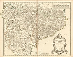
Etats de la Couronne d'Aragon, ou se trouvent les Royaumes d'Aragon et de Navarre, la Principaut� de Catalogne. Par le Sr. Robert de Vaugondy fils Geographe ordin? du Roi. Avec Privil�ge
Publication Date: 1752
Map
� 150
Convert currency� 10 shipping from United Kingdom to U.S.A.Quantity: 1 available
Add to basketCondition: Good. "Etats de la Couronne d'Aragon" Catalonia Catalunya. NE Spain VAUGONDY 1752 map. Large antique 18th century atlas map, printed on thick, good quality paper with original outline hand colour/color and decorative title cartouche; Robert de Vaugondy, Gilles & Didier (1752). 50.0 x 63.5cm, 19.5 x 25 inches; this is a folding map. Condition: Good. Please contact us if you would like to arrange to view this map. There is nothing printed on the reverse side, which is plain.".