Order Total (1 Item Items):
Shipping Destination:

Description Litalie Ancienne Gaule Cisalpine (2 results)
Feedback
Skip to main search results
Search filters
Product Type
- All Product Types
- Books (1)
- Magazines & Periodicals (No further results match this refinement)
- Comics (No further results match this refinement)
- Sheet Music (No further results match this refinement)
- Art, Prints & Posters (No further results match this refinement)
- Photographs (No further results match this refinement)
- Maps (1)
- Manuscripts & Paper Collectibles (No further results match this refinement)
Condition Learn more
- New (No further results match this refinement)
- As New, Fine or Near Fine (1)
- Very Good or Good (No further results match this refinement)
- Fair or Poor (No further results match this refinement)
- As Described (1)
Binding
- All Bindings
- Hardcover (No further results match this refinement)
- Softcover (No further results match this refinement)
Collectible Attributes
- First Edition (No further results match this refinement)
- Signed (No further results match this refinement)
- Dust Jacket (No further results match this refinement)
- Seller-Supplied Images (2)
- Not Print on Demand (2)
Language (2)
Price
- Any Price
- Under � 20 (No further results match this refinement)
- � 20 to � 35 (No further results match this refinement)
- Over � 35
Free Shipping
- Free Shipping to U.S.A. (No further results match this refinement)
Seller Location
Seller Rating
-
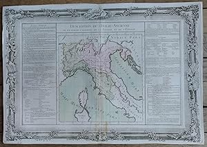
Description de l'ITALIE ancienne, de la GAULE CISALPINE, de la LIGURIE, et de l'ETRURIE
Published by Desnos, PARIS, 1761
Language: French
Map
Pas de couverture. Condition: Tr�s bon. Description de l'ITALIE ancienne, de la GAULE CISALPINE, de la LIGURIE, et de l'ETRURIE Grand document grav� (39 cm x 55.5 cm) sur papier verg� filigran�, issu de l'Atlas BUY de MORNAS, atlas m�thodique et �l�mentaire de G�ographie, Desnos, Paris, 1761 Bon �tat d'usage (carte aux contours coloris�s -pliure centrale verticale).
-

Description de L'Italie-Ancienne de la Gaule-Cisalpine, de la Ligurie, et de L'Etrurie.
Published by Artist: Desnos Louis Charles ( - 1805 ) Paris; issued in: Paris; - Louis-Charles Desnos (1725 - 1805) was both a globe maker and publisher of maps In the former capacity he was appointed globe maker to the King of Denmark but spent most of his life working in Paris Louis Charles Desnos and Claude Buy de Mornas worked together in the same establishments and issued together "La Manniere de Reconnoitre les Principales Etoiles dans le Ciel" (The Manner of Recognizing the Principal Stars in the Sky) in 1761; ca: 1700, 1725
Seller: Antique Sommer& Sapunaru KG, M�nchen, Germany
Seller rating 5 out of 5 stars

� 347.40
Convert currency� 38.92 shipping from Germany to U.S.A.Quantity: 1 available
Add to basketTechnic: Copper print, colorit: coloredcondition: Perfect condition, size (in cm): 36,5 x 53 cm cm; - Map shows northern Italy up to Campania with Corsica and partly Sardinia with floral border. Map describes left and right of Old Italy, of Gaul-Cisalpina, Liguria and Etruria.