
Order Total (1 Item Items):
Shipping Destination:

Denmark by Thomas Cowperthwait (2 results)
Skip to main search results
Search filters
Product Type
- All Product Types
- Books (2)
- Magazines & Periodicals (No further results match this refinement)
- Comics (No further results match this refinement)
- Sheet Music (No further results match this refinement)
- Art, Prints & Posters (No further results match this refinement)
- Photographs (No further results match this refinement)
- Maps (No further results match this refinement)
- Manuscripts & Paper Collectibles (No further results match this refinement)
Condition Learn more
- New (No further results match this refinement)
- As New, Fine or Near Fine (No further results match this refinement)
- Very Good or Good (No further results match this refinement)
- Fair or Poor (No further results match this refinement)
- As Described (2)
Binding
- All Bindings
- Hardcover (No further results match this refinement)
- Softcover (No further results match this refinement)
Collectible Attributes
- First Edition (No further results match this refinement)
- Signed (No further results match this refinement)
- Dust Jacket (No further results match this refinement)
- Seller-Supplied Images (2)
- Not Print on Demand (2)
Language (1)
Free Shipping
- Free Shipping to U.S.A. (No further results match this refinement)
Seller Location
Seller Rating
-
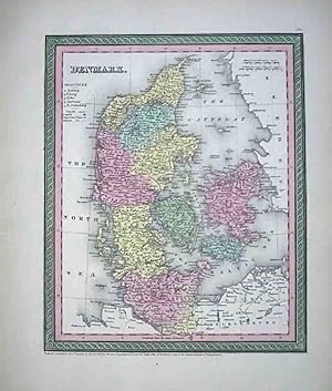
Map of Denmark from Thomas, Cowperthwait's Universal Atlas. fine condition. Full color by district. Includes the southern portion of Jutland Peninsula in Denmark, including Lauenburg and the Duchy of HolsteinMap no. 57.
-

Denmark
Publication Date: 1854
Seller: Art Source International Inc., Boulder, CO, U.S.A.
Seller rating 5 out of 5 stars

This map of Denmark was published by Thomas, Cowperthwait and Co., in 1854. Country regions, cities, towns, bodies of water, and topographical features are illustrated on this map. Original hand coloring in muted pastels and Cowperthwaits signature sage and pink border make this map a standout from other maps made during this time. ' This map measures 11.5 inches by 9.75 inches.