
Order Total (1 Item Items):
Shipping Destination:

County Map Ohio Indiana (45 results)
Skip to main search results
Search filters
Product Type
- All Product Types
- Books (35)
- Magazines & Periodicals (No further results match this refinement)
- Comics (No further results match this refinement)
- Sheet Music (No further results match this refinement)
- Art, Prints & Posters (2)
- Photographs (No further results match this refinement)
- Maps (8)
- Manuscripts & Paper Collectibles (No further results match this refinement)
Condition Learn more
- New (8)
- As New, Fine or Near Fine (1)
- Very Good or Good (6)
- Fair or Poor (No further results match this refinement)
- As Described (30)
Binding
Collectible Attributes
- First Edition (1)
- Signed (No further results match this refinement)
- Dust Jacket (No further results match this refinement)
- Seller-Supplied Images (36)
- Not Print on Demand (37)
Language (2)
Free Shipping
Seller Location
Seller Rating
-

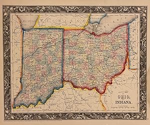
14 x 11 1/2 inches. Condition: Very good. W. H. Gamble (illustrator). This is an attractive cartographic artifact highlighting the avenues of ante-bellum commerce. The railroads supplemented the Ohio River and Great Lakes commercial systems. Indiana and Ohio were critical components of the agricultural complex of the northern states. The Ohio River serviced the ports of the states with sugar, cotton and rice. These commodities were then spread inward to points as far as New York City and Boston by the rail networks. This map will look good framed and on the wall.
-

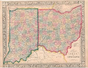
County and Township Map of the states of Ohio and Indiana
Published by Bradley, Philadelphia, 1882
Map
21 1/4 x 14 1/4 inches. Condition: Very good condition. Detailed map of the states of Indiana and Ohio on two pages published just prior to the establishment of the Interstate Commerce Commission. The significant railroads are laid out for the reader to behold. The overall pattern reflects the great connectivity experience on the eve of the introduction of the inter-urban. Each county is designated with its appropriate color in this trip-color scheme. The hubs of connection lie within the river and lake ports along with the each states capital. The grapevine exterior neatline borders provides aa attractive presentation in this important transportation map.
-

14 1/4 x 11 1/2 inches. Condition: Very good. W. H. Gamble (illustrator). 1872. Two states, Indiana and Ohio are set into this well executed cartographic presentation using a grapevine motif for the external decorative borders. Railroads ar most prominent along with the individually colored counties. The Ohio River forms the lower border of the colored area. The riverine commerce of the day was highly complemented by the railroads. By this time, the riverine commerce had lost its high value, low bulk items to the ubiquitous capacities of the railroads. This made it much easier to export grains and produce to New York by feeding the Erie Canal of the railroads connecting to New York City and its port.For the Ohio, it brought qlarge quantities of sugar and cotton to the northern states.
-

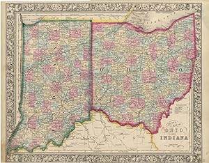
New Rail Road and County Map of Ohio & Indiana
Published by George F. Cram, [Chicago], 1882
Seller: Kaaterskill Books, ABAA/ILAB, East Jewett, NY, U.S.A.
Association Member: ABAA ILAB IOBA
Seller rating 5 out of 5 stars

One sheet (30 x 35 cm). 29 x 23.5 cm. (11 1/2 x 9 1/4 inches). Hand colored. Title inside oval cartouche. Scale 36 miles to 1 inch. Taken from "Cram's Illustrated Family Atlas of the World." There were numerous versions of the New Rail Road and County maps by published by Cram and Henry S. Stebbins, with later versions machine colored due to the expense of hand coloring. Phillips 901. Very good, some marginal browning.
-

MAP:"County Map of Ohio and Indiana.from Mitchell's Modern Atlas
Published by S. Augustus Mitchell, Philadelphia, PA, 1863
Seller: Dorley House Books, Inc., Hagerstown, MD, U.S.A.
Seller rating 4 out of 5 stars

Art / Print / Poster First Edition
Unbound. Condition: Very Good. Handcolored Map (illustrator). 1st. single sheet, lovely handcolored 1863 map with decorative border Size: 12.5" x 15". Map.
-
County Map of Ohio and Indiana
Published by S. Augustus Mitchell, Jr., New York, 1864
Seller: Main Street Fine Books & Mss, ABAA, Galena, IL, U.S.A.
Association Member: ABAA ILAB MWABA
Seller rating 5 out of 5 stars
Map
Folio (15�" X 12�", image area 14" X 11�"). Hand colored. Very good. Mild age toning and bit of soiling. Really well colored map of these Midwest side-by-siders, from the 1864 edition of "Mitchell's New General Atlas, Containing Maps of the Various Countries of the World, Plans of Cities, Etc." A lushly--colored example of these densely-countied states, with sharp floral border.
-

County & Township Map of the States of Ohio and Indiana
Published by Mitchell's, Philadelphia, 1880
Seller: Main Street Fine Books & Mss, ABAA, Galena, IL, U.S.A.
Association Member: ABAA ILAB MWABA
Seller rating 5 out of 5 stars
Map
23�" X 15�" (image 21�" X 14�"). Hand colored. Ornamental border. Near fine. Fine bright coloring.
-
Mitchell's County Map of Ohio and Indiana
Language: English
Published by Samuel Augustus Mitchell Jr., Philadelphia, 1871
Seller: Books & Bidders, Cleveland, OH, U.S.A.
Association Member: IOBA
Seller rating 5 out of 5 stars
Map
No Binding. Condition: Very Good. Hand-colored engraved map framed, visible size: 12 x 14.5 inches. frame size: 17 x 19 inches. An attractive 1871 county map of Ohio and Indiana from the atlas of S.A. Mitchell Jr., one of the leading American cartographic publisher's of the 19th century. Finely engraved and detailed, the map shows counties, townships, cities, rivers, and an extensive network of railroads reflecting the rapid post-Civil War expansion of transportation infrastructure throughout the Midwest. Original outline hand-coloring in soft pastels distinguished county boundaries, with Lake Erie and the Ohio River prominently delineated. The map is enclosed within Mitchell's characteristic ornamental floral border, with the title cartouche at lower right reading "County Map of Ohio and Indiana," accompanied by a printed explanation key. Mitchell's 1871 atlas is especially noted for their clarity of engraving and decorative appeal, making them desirable examples of American commercial cartography. Expected light toning consistent with 19th-century paper. Some light scattered foxing. Hand-coloring remains fresh and well-preserved. No visible tears or losses. Overall condition: very good, attractively presented.
-
![Seller image for The western tourist; or, Emigrant's guide through the states of Ohio, Michigan, Indiana, Illinois, and Missouri, and the territories of Wisconsin and Iowa: being an accurate and concise description of each state, territory, and county. Also, describing all the principal stage routes, canals, railroads, and the distances between the towns. Accompanied with a correct map, showing the township lines of the United States' surveys, the boundaries of counties, position of villages, etc. 1846 [LeatherBound] for sale by S N Books World](https://pictures.abebooks.com/inventory/md/md30877197952.jpg)
LeatherBound. Condition: NEW. BOOKS ARE EXEMPT FROM IMPORT DUTIES AND TARIFFS; NO EXTRA CHARGES APPLY. Leatherbound edition. Condition: New. Leather Binding on Spine and Corners with Golden leaf printing on spine. Bound in genuine leather with Satin ribbon page markers and Spine with raised gilt bands. Pages: 130. A perfect gift for your loved ones. Reprinted from 1846 edition. NO changes have been made to the original text. This is NOT a retyped or an ocr'd reprint. Illustrations, Index, if any, are included in black and white. Each page is checked manually before printing. As this print on demand book is reprinted from a very old book, there could be some missing or flawed pages, but we always try to make the book as complete as possible. Fold-outs, if any, are not part of the book. If the original book was published in multiple volumes then this reprint is of only one volume, not the whole set. IF YOU WISH TO ORDER PARTICULAR VOLUME OR ALL THE VOLUMES YOU CAN CONTACT US. Resized as per current standards. Sewing binding for longer life, where the book block is actually sewn (smythe sewn/section sewn) with thread before binding which results in a more durable type of binding. Language: English Pages: 130.
-
![Seller image for The western tourist or emigrant's guide through the states of Ohio, Michigan, Indiana, Illinois, and Missouri, and the territories of Wisconsin and Iowa : being an accurate and concise description of each state, territory, and county : also, describing all the principal stage routes, canals, railroads, and the distances betwen the towns : accompanied with a correct map, showing the township lines of the United States' surveys, the boundaries of counties, position of villages, etc 1847 [LeatherBound] for sale by S N Books World](https://pictures.abebooks.com/inventory/md/md30639876346.jpg)
Leatherbound. Condition: NEW. BOOKS ARE EXEMPT FROM IMPORT DUTIES AND TARIFFS; NO EXTRA CHARGES APPLY. Leatherbound edition. Condition: New. Leather Binding on Spine and Corners with Golden leaf printing on spine. Bound in genuine leather with Satin ribbon page markers and Spine with raised gilt bands. Pages: 138. A perfect gift for your loved ones. Reprinted from 1847 edition. NO changes have been made to the original text. This is NOT a retyped or an ocr'd reprint. Illustrations, Index, if any, are included in black and white. Each page is checked manually before printing. As this print on demand book is reprinted from a very old book, there could be some missing or flawed pages, but we always try to make the book as complete as possible. Fold-outs, if any, are not part of the book. If the original book was published in multiple volumes then this reprint is of only one volume, not the whole set. IF YOU WISH TO ORDER PARTICULAR VOLUME OR ALL THE VOLUMES YOU CAN CONTACT US. Resized as per current standards. Sewing binding for longer life, where the book block is actually sewn (smythe sewn/section sewn) with thread before binding which results in a more durable type of binding. Language: English Pages: 138.
-
County Map of Ohio, and Indiana
Published by Mitchell, Samuel Augustus Jr., Philadelphia, 1860
Seller: Argosy Book Store, ABAA, ILAB, New York, NY, U.S.A.
Seller rating 5 out of 5 stars
unbound. Map. Engraving with original hand coloring. Image measures 10 1/2" x 13 1/4". Nicely detailed map of Ohio and Indiana showing counties, towns, major routes and waterways. Features an elaborately engraved decorative border. In very good condition, with minor damp stains to lower right corner, not affecting the image. Samuel Augustus Mitchell Sr. (1792-1868) was one of the leaders in American cartography of the 19th century and pioneered the conversion of engraved map plates to more affordable lithographic plates. His son, Samuel Augustus Mitchell Jr. continued his father's successful mapmaking and publishing business, and was one of the most prolific and renowned 19th century American publishers.
-
County Map of Ohio and Indiana
Published by S. Augustus Mitchell, Jr., New York, 1864
Seller: Main Street Fine Books & Mss, ABAA, Galena, IL, U.S.A.
Association Member: ABAA ILAB MWABA
Seller rating 5 out of 5 stars
Map
Folio (15�" X 12�", image area 14" X 11�"). Hand colored. Very good. Some age toning. Extensively colored map of these two side-by-side Midwest states, from the 1864 edition of "Mitchell's New General Atlas, Containing Maps of the Various Countries of the World, Plans of Cities, Etc." A very full-colored example of these many-countied states, with bold decorative border.
-
County Map of Ohio and Indiana.
Published by Philadelphia:, 1869
Seller: Nicholas D. Riccio Rare Books, ABAA, Florham Park, NJ, U.S.A.
Seller rating 4 out of 5 stars
Unbound, colored engraved map, decorative boarder, 14"x 11". Slight toning and aging, margins a somewhat narrow, but still ample; bright and clear, and in otherwise very good shape. Maps are wrapped with acid free board, or in rigid sleeves. The Mitchell family started to produce atlases in 1846, and continued into the early 1890s. Around 1860, S. Augustus Mitchell Jr. took over, and the atlas would be called Mitchell's New General Atlas. This is an attractive colorful single page map of Ohio and Indiana from the 1869 installment of that atlas. Ristow 311-313.
-
County Map of Ohio and Indiana.
Published by Philadelphia:, 1870
Seller: Nicholas D. Riccio Rare Books, ABAA, Florham Park, NJ, U.S.A.
Seller rating 4 out of 5 stars
Unbound, colored engraved map, decorative boarder, 14"x 11". Slight toning and aging; a few edge nicks,bright and clear, and in otherwise very good shape. Maps are wrapped with acid free board, or in rigid sleeves. The Mitchell family started to produce atlases in 1846, and continued into the early 1890s. Around 1860, S. Augustus Mitchell Jr. took over, and the atlas would be called Mitchell's New General Atlas. This is an attractive colorful single page map of Ohio and Indiana from the 1870 installment of that atlas. Ristow 311-313.
-
County Map of Ohio and Indiana
Published by Philadelphia, 1864
Seller: Nicholas D. Riccio Rare Books, ABAA, Florham Park, NJ, U.S.A.
Seller rating 4 out of 5 stars
Unbound, colored engraved map, decorative border, 14"x 11 1/2". Slight toning and aging; otherwise bright and clean. Maps are wrapped with acid free board, or in rigid sleeves. The Mitchell family started to produce atlases in 1846, and continued into the early 1890s. Around 1860, S. Augustus Mitchell Jr. took over, and the atlas would be called Mitchell's New General Atlas. This is an attractive colorful single page map of the states of Ohio and Indiana from the 1864 installment of that atlas. Ristow 311-313.
-
County and Township Map of the States of Ohio and Indiana
Published by Bradley, Philadelphia, 1882
Seller: Nicholas D. Riccio Rare Books, ABAA, Florham Park, NJ, U.S.A.
Seller rating 4 out of 5 stars
Unbound, colored engraved map, decorative border, 22 1/2"x 14 1/2". Slight toning and aging; otherwise bright and clean. Maps are wrapped with acid free board, or in rigid sleeves. The Mitchell family started to produce atlases in 1846, and continued into the early 1890s. Around 1860, S. Augustus Mitchell Jr. took over, and the atlas would be called Mitchell's New General Atlas. This is an attractive colorful double page map of the states of Ohio and Indiana from the 1882 installment. Two of the Great Lakes are present, and part of Kentucky is visible. Ristow 311-313 Phillips 907.
-
County Map of Ohio and Indiana
Published by Philadelphia, 1861
Seller: Nicholas D. Riccio Rare Books, ABAA, Florham Park, NJ, U.S.A.
Seller rating 4 out of 5 stars
Unbound, colored engraved map, decorative border, 14"x 11 1/2". Slight toning and aging, some staining and browning in margins; but still bright and clean. Maps are wrapped with acid free board, or in rigid sleeves. The Mitchell family started to produce atlases in 1846, and continued into the early 1890s. Around 1860, S. Augustus Mitchell Jr. took over, and the atlas would be called Mitchell's New General Atlas. This is an attractive colorful single page map of the states of Ohio and Indiana from the 1861 installment of that atlas. Ristow 311-313.
-

County Map of Ohio and Indiana
Publication Date: 1864
Seller: Art Source International Inc., Boulder, CO, U.S.A.
Seller rating 5 out of 5 stars
With characteristic floral boarders and beautiful, muted pastel coloring, these 1864 maps are fantastic examples of Mitchells work. Counties, important cities, mountain ranges, rivers, lakes, and railroads are identified. This hand colored map illustrates the states of Indiana and Ohio. This map measure 14 inches by 11.5 Inches.
-

County Map of Ohio and Indiana
Publication Date: 1872
Seller: Art Source International Inc., Boulder, CO, U.S.A.
Seller rating 5 out of 5 stars
This map of Ohio and Indiana was made by S. Augustus Mitchell in 1872. The traditional ivy border, and hand coloring make this map beautiful. This US State map shows transportation routes, rivers, towns, and topography features. Counties are distinguished by various pastel colors. Very Detailed! This map measure 11 inches by 13.5 Inches.
-

County and Township Map of the States of Ohio and Indiana
Publication Date: 1877
Seller: Art Source International Inc., Boulder, CO, U.S.A.
Seller rating 5 out of 5 stars
This hand colored map was made in 1877 by S. Augustus Mitchell for "Mitchells New General Atlas" in 1877. Ohio and Indiana are illustrated on this map. Counties are distinguished by color. Other details include the names of counties and important cities, major roads, rivers, lakes, and railroads. This map measure 21 inches by 14 Inches.
-

County Map of Ohio and Indiana
Publication Date: 1867
Seller: Art Source International Inc., Boulder, CO, U.S.A.
Seller rating 5 out of 5 stars
The Mitchell company was one of the first to try out the newtechnique of engraving on steel plates, experimenting with steelalmost 20 years before the rest of the publishing industry. Hewas printing with steel in the early 1830s; the general switch tosteel was approximately 1850. During the early years of thecompany, Mitchell published mainly maps and travel guides. In1860, Mitchell started producing "Mitchell's New General Atlas",and Mitchell Sr. retired and turned the business over to his sonof the same name. The New General Atlas was published until1893. Today Mitchell maps are sought after for their fineengraving, bright coloring, and attention to detail. They aresome of the finest maps produced in the 1860's. This mapproduced in 1867, has Mitchell's unique floral border, and beautiful hand coloring. This map details the states of Arkansas, Mississippi, and Louisiana. Counties, cities, towns, railroads, transportation routes and topographical features are noted. This map measure 13.5 inches by 11 Inches.
-
![Seller image for The western tourist : or, Emigrant's guide through the states of Ohio, Michigan, Indiana, Illinois, and Missouri, and the territories of Wisconsin and Iowa: being an accurate and concise description of each state, territory, and county / Also, describing all the principal stage routes, canals, railroads, and the distances between the towns. Accompanied with a correct map, showing the township lines of the United States' surveys, the boundaries of counties, position of villages, etc. 1839 [LeatherBound] for sale by S N Books World](https://pictures.abebooks.com/inventory/md/md30877367759.jpg)
LeatherBound. Condition: NEW. BOOKS ARE EXEMPT FROM IMPORT DUTIES AND TARIFFS; NO EXTRA CHARGES APPLY. Leatherbound edition. Condition: New. Leather Binding on Spine and Corners with Golden leaf printing on spine. Bound in genuine leather with Satin ribbon page markers and Spine with raised gilt bands. Pages: 194. A perfect gift for your loved ones. Reprinted from 1839 edition. NO changes have been made to the original text. This is NOT a retyped or an ocr'd reprint. Illustrations, Index, if any, are included in black and white. Each page is checked manually before printing. As this print on demand book is reprinted from a very old book, there could be some missing or flawed pages, but we always try to make the book as complete as possible. Fold-outs, if any, are not part of the book. If the original book was published in multiple volumes then this reprint is of only one volume, not the whole set. IF YOU WISH TO ORDER PARTICULAR VOLUME OR ALL THE VOLUMES YOU CAN CONTACT US. Resized as per current standards. Sewing binding for longer life, where the book block is actually sewn (smythe sewn/section sewn) with thread before binding which results in a more durable type of binding. Language: English Pages: 194.
-

County Map of Ohio, and Indiana. - County map of Ohio and Indiana published shortly before the start of the Civil War.
Publication Date: 1860
Seller: Curtis Wright Maps, Berwyn, IL, U.S.A.
Seller rating 4 out of 5 stars
Condition: Fine. This attractive map of Ohio and Indiana was published in Philadelphia in 1860 by Samuel Augustus Mitchell. Mitchell was one of the most prominent American mapmakers of the 19th century and initially got involved with cartography as a school teacher who was frustrated with the quality of available maps. He collaborated with skilled engravers and produced high-quality maps and atlases that contained the most up-to-date information available. Mitchell's son would take over the business after his death in 1860 and continue the tremendous output. His attention to detail is evident within the image, which provides an informative snapshot of the Hoosier and Buckeye States shortly before the outbreak of the Civil War. Counties are colored in a distinctive hue and finely engraved lines label an interesting variety of place names, geographic features, and other locations of interest. A robust transportation network of roads, canals, and railroads is shown throughout the image, including routes under construction. The two Midwestern states are largely flat, thus omitting the need for topographic detail. Sheet Width (in) 15.25 Sheet Height (in) 12.25 Condition Description A few scattered spots visible in the margins and the border has a somewhat faint impression. Very good overall, with vibrant original color.
-

County and Township Map of the States of Ohio and Indiana
Publication Date: 1881
Seller: Art Source International Inc., Boulder, CO, U.S.A.
Seller rating 5 out of 5 stars
This map came from Mitchells New General Atlas, 1881.The traditional ivy border, and hand coloring make this mapbeautiful. This double page, US State map shows transportation routes,rivers, towns, and topography features. Very Detailed!' This map measure 21 inches by 14.25 Inches.
-

County & Township Map of the States of Ohio and Indiana
Publication Date: 1878
Seller: Art Source International Inc., Boulder, CO, U.S.A.
Seller rating 5 out of 5 stars
This map was produced by Augustus Mitchell in 1878 for his New General Atlas. Highlights of this map are Mitchells traditional grapevine border, characteristic pastel coloring and abundant details of geographical features. This is a county and township map of the states of Ohio and Indiana. Towns and neighborhoods are distinguished by color. This 1878 map offers a fascinating perspective of areas that have since undergone significant growth and change, in addition to the value as great examples of Mitchell's classic mapmaking style. This map measure 21.5 inches by 14.25 Inches.
-

County Map of Ohio and Indiana
Publication Date: 1870
Seller: Art Source International Inc., Boulder, CO, U.S.A.
Seller rating 5 out of 5 stars
S. Augustus Mitchell made this hand colored map for Mitchells New General Atlas in 1870. This map illustrates Ohio and Indiana. Counties are distinguished by bright pastel colors. Other details include the names of counties, important cities, railroads, proposed railroads, and major roads. This map measure 14 inches by 11.5 Inches.
-

Map of Ohio County, Indiana
Publication Date: 1876
Seller: Art Source International Inc., Boulder, CO, U.S.A.
Seller rating 5 out of 5 stars
This detailed county map was originally published in the "Illustrated Historical Atlas of the State of Indiana." Published on the countrys centennial, this is a dramatic and wonderful work that was a celebration of the nation's settlement and development. These maps epitomize the best of late 19th century American map making, as they contain great cartography, but more so have a flair for presentation that speaks so much of the aesthetic of the age. The maps have an intricate decorative border, and abound with fancy title blocks and decorative scrolling. Amazingly, these maps not only give us the roads and towns of the time, but even show us locations of homes and churches, as well as rivers and wetlands. These are unrivaled genealogical resources and wonderful decorative items. Condition is very good. This map measure 13 inches by 16 Inches.
-

County Map of Ohio and Indiana
Publication Date: 1875
Seller: Art Source International Inc., Boulder, CO, U.S.A.
Seller rating 5 out of 5 stars
This map was produced by S. Augustus Mitchell in 1875 for his New General Atlas. This map shows Mitchells traditional grape vine border, characteristic pastel coloring and abundant details of geographical features. Counties are distinguished by different colors. Wagon trails and major routes of transport are also shown. These 1875 maps offer a fascinating perspective of areas that have since undergone significant growth and change, in addition to their value as great examples of Mitchell's work. This map measure 14 inches by 11.5 Inches.
-

County Map of Ohio and Indiana
Publication Date: 1866
Seller: Art Source International Inc., Boulder, CO, U.S.A.
Seller rating 5 out of 5 stars
The Mitchell company was one of the first to try out the new technique of engraving on steel plates experimenting with steel almost 20 years before the rest of the publishing industry. He was printing with steel in the early 1830s; the general switch to steel was approximately 1850. During the early years of the company, Mitchell published mainly maps and travel guides. In 1860, Mitchell started producing "Mitchell's New General Atlas",and Mitchell Sr. retired and turned the business over to his son of the same name. The New General Atlas was published until 1893. Today Mitchell maps are sought after for their fine engraving, bright coloring, and attention to detail. They are some of the finest maps produced during this time period. This map produced in 1866, has Mitchell's unique floral border, and beautiful hand coloring. This map details the states of Ohio and Indiana. Counties, cities, towns, lakes, rivers, mountains, and transportation routes are noted. Each map was printed on thick paper with vibrant hand color. This map measure 11.5 inches by 14 Inches.
-

County Map of Ohio and Indiana
Publication Date: 1868
Seller: Art Source International Inc., Boulder, CO, U.S.A.
Seller rating 5 out of 5 stars
This hand colored map was made for "Mitchells New General Atlas" published in 1868 by S. Augustus Mitchell, Jr. Ohio is illustrated on this map. Counties are distinguished by color. Other details include the names of counties and important cities, railroads, major roads,and rivers. The pastel coloring in this atlas is very beautiful and more muted than typical. This map measure 14 inches by 11.5 Inches.

