
Order Total (1 Item Items):
Shipping Destination:

Cornwall by Morden Robert (4 results)
Skip to main search results
Search filters
Product Type
- All Product Types
- Books (No further results match this refinement)
- Magazines & Periodicals (No further results match this refinement)
- Comics (No further results match this refinement)
- Sheet Music (No further results match this refinement)
- Art, Prints & Posters (No further results match this refinement)
- Photographs (No further results match this refinement)
- Maps (4)
- Manuscripts & Paper Collectibles (No further results match this refinement)
Condition Learn more
- New (No further results match this refinement)
- As New, Fine or Near Fine (1)
- Very Good or Good (2)
- Fair or Poor (No further results match this refinement)
- As Described (1)
Binding
- All Bindings
- Hardcover (No further results match this refinement)
- Softcover (2)
Collectible Attributes
- First Edition (No further results match this refinement)
- Signed (No further results match this refinement)
- Dust Jacket (No further results match this refinement)
- Seller-Supplied Images (4)
- Not Print on Demand (4)
Language (2)
Price
- Any Price
- Under � 20 (No further results match this refinement)
- � 20 to � 35 (No further results match this refinement)
- Over � 35
Free Shipping
- Free Shipping to U.S.A. (No further results match this refinement)
Seller Location
Seller Rating
-
Cornwall
Language: English
Seller: Roger Collicott Books, Widecombe in the Moor, DEVON, United Kingdom
Seller rating 5 out of 5 stars

Map
Map. Condition: Good. Circa 1701. Attractive early eighteenth century map with contempory outline hand colouring. Size : 210 x 160 mm. Small repair in lower margin. C10.
-

Cornwall
Language: English
Publication Date: 1695
Seller: Roger Collicott Books, Widecombe in the Moor, DEVON, United Kingdom
Seller rating 5 out of 5 stars
Map
Map. Condition: Fine. Beautiful restrained hand colouring. Copper engraved late 17th century map on quality paper. Size : 425 x 355 mm.
-
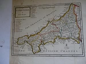
Cornwall by Robert Morden [ANTIQUE MAP 1722]
Published by Printed for Abel Swall and Awnsham & John Churchill
Seller: K Books Ltd ABA ILAB, York, YORKS, United Kingdom
Association Member: ABA ILAB PBFA
Seller rating 5 out of 5 stars
Map
No Binding. Condition: Very Good. MORDEN, Robert (illustrator). Copperplate engraved map, map undated but from 'Camden's Britannia', the Second Edition printed in 1722 by the most famous British cartographer Robert Morden, map measures 18.5 x 15.5 inches or 47 x 39cms which includes the margins (double page folio), folded map, clean and crisp and in splendid condition. The reverse of map is blank. Will post unmounted and rolled in a tube. ADDITIONAL POSTAGE WILL BE CHARGED TO MAKE UPTO UK postage rate of �5.89.
-

Cornwall
Published by London, 1695
Seller: Clive A. Burden Ltd., Chalfont St. Giles, BUCKS, United Kingdom
Seller rating 5 out of 5 stars
Map
No binding. 360 x 420 mm., small margin tear on left repaired, not affecting image, otherwise in good condition with tall margins. From Edmund Gibson's edition of Camden's 'Britannia'. Gibson announced that his maps engraved by Robert Morden utilised unpublished surveys where available and the knowledge of local gentlemen who supplied corrections. Morden was an accomplished bookseller and publisher who contributed a great deal to geography and cartography. Morden's maps were very popular. William Camden's 'Britannia' with this series of maps was first published in 1695, and subsequently in 1722, c.1730, 1753 & 1772. Quixley (1966) no. 19; Skelton no. 117.
![Seller image for Cornwall by Robert Morden [ANTIQUE MAP 1722] for sale by K Books Ltd ABA ILAB](https://pictures.abebooks.com/inventory/md/md31904856448.jpg)