
Order Total (1 Item Items):
Shipping Destination:

Comitatus Hollandia (12 results)
Skip to main search results
Search filters
Product Type
- All Product Types
- Books (8)
- Magazines & Periodicals (No further results match this refinement)
- Comics (No further results match this refinement)
- Sheet Music (No further results match this refinement)
- Art, Prints & Posters (3)
- Photographs (No further results match this refinement)
- Maps (1)
- Manuscripts & Paper Collectibles (No further results match this refinement)
Condition Learn more
Binding
- All Bindings
- Hardcover (7)
- Softcover (No further results match this refinement)
Collectible Attributes
- First Edition (No further results match this refinement)
- Signed (No further results match this refinement)
- Dust Jacket (3)
- Seller-Supplied Images (7)
- Not Print on Demand (12)
Language (3)
Free Shipping
- Free Shipping to U.S.A. (No further results match this refinement)
Seller Location
Seller Rating
-

Hollandia Comitatus. Een kartobibliografie van Holland.
Published by Hes en de Graaf Nieuw exemplaar, nog in het folie. [#3885
Seller: Antiquariaat De Boekenbeurs, Middelburg, Netherlands
Seller rating 5 out of 5 stars

Hes en de Graaf Nieuw exemplaar, nog in het folie.
-

Hollandia Comitatus. Een kartobibliografie van Holland.
Seller: Antiquariaat A. Kok & Zn. B.V., Amsterdam, Netherlands
Seller rating 5 out of 5 stars
[Houten], HES & De Graaf Publishers BV., [2000]. 487 pp. b./w. ills. Orig. hardcover (clothbound), d./j. 4to. - Dust jacket partly discol. along the top edge. (Utrechtse Historisch-Kartografische studies).This attractive and profusely illustrated book offers for the first time a complete survey of all printed maps of the former county of Holland. The reader obtains an excellent insight into the development of the typically Dutch landscape through the ages. Over a hundred maps from the period of 1542 to the beginning of the Kingdom of the Netherlands show the results of impoldering, peat cutting and town extensions in the provinces of North and South Holland. Many maps from this period are richly decorated. Beside the geographical and cartographical developments this book also gives a good picture of the developments which took place in the artistic field. - Text in Dutch with an extensive summary in English.
-

Hollandia Comitatus: Een Kartobibliografie Van Holland
Language: Dutch
Published by HES & DE GRAAF Publishers BV, 2000
ISBN 10: 906194418X ISBN 13: 9789061944188
Hardcover met stofomslag. Condition: Fair. Condition: Redelijk. Binding: Hardcover met stofomslag. Year: 2000. Description: Boek zeer goed. Stofomslag strak echter met iets verkleurde rug. Lichte gebruik-/opslagsporen.
-

Hollandia Comitatus: Een Kartobibliografie Van Holland
Language: Dutch
Published by HES & DE GRAAF Publishers BV, 2000
ISBN 10: 906194418X ISBN 13: 9789061944188
Hardcover. Condition: Good. Condition: Goed. Binding: Hardcover. Year: 2000. Description: Boek zeer goed, stofomslag strak met krasjes en lichte verkleuring rug. .
-
Hollandia Comitatus
Published by HES & De Graaf, 2000
Seller: Arader Galleries of Philadelphia, PA, Philadelphia, PA, U.S.A.
Seller rating 4 out of 5 stars

Hardcover. Condition: New. Dust Jacket Condition: new. still in publishers shrink wrap.
-

Hollandia Comitatus: Een Kartobibliografie Van Holland (Utrecht Studies in the History of Cartography / Utrechtse Historisch-kartografische Studies) (Dutch Edition)
Language: Dutch
Published by Hes & De Graff Pub B V, 2000
ISBN 10: 906194418X ISBN 13: 9789061944188
Seller: Books From California, Simi Valley, CA, U.S.A.
Seller rating 4 out of 5 stars
Hardcover. Condition: Fine. Brand New! Sealed in publisher's shrinkwrap. Never opened! No signs of wear.
-
-

"Hollandia Comitatus"- Holland Niederlande Netherlands Belgien Belgium Belgique map Karte Gerard Mercator
Language: Latin
Published by Amsterdam, Janssonius, 1651
Seller: Antiquariat Steffen V�lkel GmbH, Seubersdorf, Germany
Seller rating 5 out of 5 stars
Art / Print / Poster
Blatt-Ma�e: ca. 17,5 x 23 cm -- Original Kupferstich-Karte von Gerard Mercator. R�ckseitig mit deutschem Text. Aus der deutschen Ausgabe des "Atlas Minor" von 1651. - gut erhalten. || Rare original copper engraved map by Gerard Mercator. With German text on verso. From the German edition of the "Atas Minor" from the year 1651. -- in very good condition. || The Flemish engraver and cartographer Jodocus Hondius (15631612), bought Mercator's plates after his death, and published this reduced version of Mercator's folio "Atlas sive Cosmographis", and added some 36 of his own maps - a "pocketversion" - "Atlas Minor" - which Hondius published together with his partners Cornelius Claesz and Johannes Janssonius. It became a large success, and was translated into several languages and issued in c. 40 editions. // Wir, das Antiquariat Steffen V�lkel, kaufen und verkaufen alte B�cher, Handschriften, Zeichnungen, Autographen, Grafiken und Fotografien. Wir sind stets am Ankauf von kompletten Bibliotheken, Sammlungen und Nachl�ssen interessiert. la Gewicht in Gramm: 10.
-
Hollandia Comitatus. Een kaartbibliografie van Holland.
Seller: Antiquariaat Wim de Goeij, Kalmthout, ANTW, Belgium
Association Member: ILAB
Seller rating 5 out of 5 stars
8. 't Goy-Houte (Netherlands) , Hes & de Graaf, 2000 , in-4�, 32 x 24 cm, 487 pp, black/white ills., publisher's cloth with printed dust wrapper. ISBN 906194418x. Book in Dutch. Boek in het Nederlands.
-

Hollandia comitatus
Published by Amsterdam, 1650
Seller: libreria antiquaria perini Sas di Perini, Verona, VR, Italy
Seller rating 5 out of 5 stars
Art / Print / Poster
Incisione in rame, mm 393x525, coloritura a mano coeva, testo latino al verso. Elegante e piacevole carta, tratta da Atlas Novus, arricchita da un bel cartiglio con stemmi. Buon esemplare su foglio lievemente arrossato, rinforzo alle estremit? della piega centrale. W. Blaeu, astronomo allievo di Tycho Brahe, fond� un�officina per la costruzione di globi nel 1599; quasi immediatamente inizi� a pubblicare anche carte geografiche, giungendo nel 1630 alla creazione del primo atlante �Atlantis Appendix� e cinque anni dopo, della prima edizione in due tomi del �Atlas Novus�. Dopo la sua morte nel 1638, a cura del figlio Johan si giunse nel 1662 alla pubblicazione del celebre �Atlas Maior� in 11 volumi. Nel 1672 un incendio distrusse l�officina e segn� la fine dell�attivit? Nr.cat: Cod 9640.
-
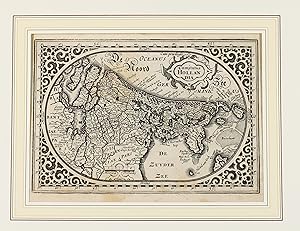
"Comitatus Hollandia".
Seller: Antiquariat Peter Fritzen, Speicher, Germany
Seller rating 5 out of 5 stars
Map
Kupferstich-Karte von Abraham Goos, Amsterdam 1616-25. 11,9 x 17,5 cm. Koeman, Atlantes Neerlandici, Goo 1-3. Au�ergew�hnliche querovale Karte mit sehr dekorativen Arabesken in den Zwickeln. Oben Rechts befindet sich eine Rollwerktitelkartusche, dar�ber das Privileg "Cum privileg.". Unten Mitte Meilenzeigerkartusche. Zweiter Zustand der erstmals 1616 ver�ffentlichten Karte, nunmehr mit dem hinzugef�gten Privileg. Die Original-Kupferplatten wurden sp�ter von J. Janssonius f�r Ausgaben des Atlas minor verwendet. Da hier allerdings kein R�ckentext vorhanden ist, d�rfte es sich um einen Abzug aus dem "Niieuw Nederlansch Caertboek" handeln.
-

Hollandia Comitatus.
Publication Date: 1640
Seller: BOTTEGHINA D'ARTE GALLERIA K�PROS, Rosignano Solvay, LI, Italy
Seller rating 3 out of 5 stars

Art / Print / Poster
No legatura. Condition: Discreto. Amsterdam, 1640 circa. Incisione in rame all'acquaforte, colore d'epoca, cm 39,5 x 53 (alla lastra), testo francese al verso. Tracce di umido e fioriture, nell'insieme in discreto stato l'inciso.
