
Order Total (1 Item Items):
Shipping Destination:

Coltons New Township Map State by Colton Joseph Hutchins (2 results)
Feedback
Skip to main search results
Search filters
Product Type
- All Product Types
- Books (No further results match this refinement)
- Magazines & Periodicals (No further results match this refinement)
- Comics (No further results match this refinement)
- Sheet Music (No further results match this refinement)
- Art, Prints & Posters (No further results match this refinement)
- Photographs (No further results match this refinement)
- Maps (2)
- Manuscripts & Paper Collectibles (No further results match this refinement)
Condition Learn more
- New (No further results match this refinement)
- As New, Fine or Near Fine (No further results match this refinement)
- Very Good or Good (2)
- Fair or Poor (No further results match this refinement)
- As Described (No further results match this refinement)
Binding
- All Bindings
- Hardcover (1)
- Softcover (No further results match this refinement)
Collectible Attributes
- First Edition (No further results match this refinement)
- Signed (No further results match this refinement)
- Dust Jacket (No further results match this refinement)
- Seller-Supplied Images (2)
- Not Print on Demand (2)
Language (1)
Price
- Any Price
- Under � 20 (No further results match this refinement)
- � 20 to � 35 (No further results match this refinement)
- Over � 35
Free Shipping
- Free Shipping to United Kingdom (No further results match this refinement)
Seller Location
Seller Rating
-
Colton's Railroad & Township Map of the State of New York With Parts of the adjoining states & Canada
Published by G.W. and C. B. Colton & Co, New York, 1870
Map
� 545.38
Convert currency� 25.78 shipping from U.S.A. to United KingdomQuantity: 1 available
Add to basketHardcover. Condition: Very good. New York: G. W. and C. B. Colton & Co., 1870. Folding hand-colored lithographed case map (25 7/16" x 28 3/4", 647mm x 730mm) of New York, including parts of Connecticut, Vermont, New Hampshire, Massachusetts, Connecticut, Ontario, and Quebec. Bound in the publisher's brown cloth case. Title gilt to the front board. Advertisements to the front paste-down. The case starting at the head and tail. Splitting and tanning along folds, with losses at the intersections. Splits to the joints. Bookseller's ticket of "S. G. Boyd, dealer in books, stationery, newspapers, sheet music &c. &c. Glens Falls, N. Y." to the front paste-down. Ownership signature of A.J. McNaught in graphite to the front paste-down. First published 1852, this pocket map of New York State captures a time of rapid growth and massive change. Colton was a major publisher of maps, and this map of New York, updated continuously, records the changes and growth New York experienced in this era. This 1870 edition shows many new developments, often in what were previously rural areas. Increased development in further-out areas always necessitates forms of transportation to reach these new areas. In the case of late-XIXc New York, railroads drove development, which drove demand for more transportation. Just on this map, formerly rural areas in Westchester, Rockland, and Nassau Counties began to become suburbs. In the past, suburban towns had sprung up along railroad main lines -- for example, the New York Central's New York-to-Chicago Water Level Route or the New Haven Railroad's New York-to-Boston Shore Line -- but starting around this era, railroads began to build dedicated commuter lines. The New York Central's Harlem Division and Long Island Railroad's Oyster Bay Branch both opened soon before this map was published, and even to this day host small railroad suburbs around them. In the Upper Hudson Valley, for example, this map shows the beginnings of the construction of the Ulster & Delaware Railroad. This railroad, which eventually ran across the Catskills from Kingston to Oneonta, was instrumental in creating the resorts that dotted the peaks of the Catskills until the 1950's. The map provides a look into the various ways in which the state transformed from a largely rural landmass to a thriving state with everything from wild mountain ranges to America's largest city.Catalogued by Jonah Kramer.
-
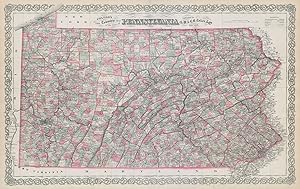
Condition: Good. Colton's Pennsylvania. Decorative antique US state map 1869 old. Antique engraved hand coloured atlas map; Joseph Hutchins Colton (1869). 42.5 x 68.0cm, 16.75 x 26.75 inches; this is a folding map. Condition: Good. There is text printed on the reverse side.
