Order Total (1 Item Items):
Shipping Destination:

Coltons Map Vermont (11 results)
Skip to main search results
Search filters
Product Type
- All Product Types
- Books (6)
- Magazines & Periodicals (No further results match this refinement)
- Comics (No further results match this refinement)
- Sheet Music (No further results match this refinement)
- Art, Prints & Posters (No further results match this refinement)
- Photographs (No further results match this refinement)
- Maps (5)
- Manuscripts & Paper Collectibles (No further results match this refinement)
Condition Learn more
- New (No further results match this refinement)
- As New, Fine or Near Fine (2)
- Very Good or Good (3)
- Fair or Poor (No further results match this refinement)
- As Described (6)
Binding
Collectible Attributes
- First Edition (No further results match this refinement)
- Signed (No further results match this refinement)
- Dust Jacket (No further results match this refinement)
- Seller-Supplied Images (8)
- Not Print on Demand (11)
Language (2)
Price
- Any Price
- Under � 20 (No further results match this refinement)
- � 20 to � 40 (No further results match this refinement)
- Over � 40
Free Shipping
- Free Shipping to U.S.A. (No further results match this refinement)
Seller Location
Seller Rating
-

Pamphlet. Condition: Good. Map is 18.5 x 16 inches, Elaborate border, Hand-WaterColored in Pastels, 1 inch area of extreme upper right corner slightly toned but scarcely visible, else Attractive & Could be Beautifully Framed (Map is dated 1855).
-
Hardcover. Condition: Near Fine. No Jacket. Scarce copy of Colton's 1881 folding pocket map of Vermont in near mint condition.Map is 14 by 18 inches. We could find no other copies for sale. Hand colored.
-
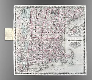
Colton's Railroad & Township Map of Massachusetts, Rhode Island, Connecticut with parts of Maine, New Hampshire, Vermont & New York
Published by G.W. & C.B. Colton, New York, 1876
Seller: Donald A. Heald Rare Books (ABAA), New York, NY, U.S.A.
Seller rating 5 out of 5 stars

Map
Folding pocket map, full period hand coloring. Inset of the British Provinces on the Gulf of St. Lawrence. Folds into publisher's blindstamped cloth covers, title stamped in gilt in the upper cover, Colton ad on the front pastedown. Large and colorful Colton map of New England. This decorative map depicts the region from New York City in the southwest corner to Searsmont, Maine in the northeast corner, with the Saranac Lakes in the northwest corner. Both counties and townships are identified, with many towns named. Roads, waterways and railroads are all shown.
-

Colton's Railroad & Township Map of Massachusetts, Rhode Island and Connecticut, with Parts of Maine, New Hampshire, Vermont & New York
Published by New York, New York, 1890
Seller: High Ridge Books, Inc. - ABAA, South Deerfield, MA, U.S.A.
Association Member: ABAA ESA ILAB SNEAB
Seller rating 5 out of 5 stars
Pocket map with original cloth folder. fine condition. Full color by town in the New England states, by county in New York. Inset at right side of the Canadian maritime provinces of Nova Scotia, New Brunswick and Prince Edward Island. Also shows the western half of Newfoundland and southern Quebec from Montreal to the Gulf of St. Lawrence. Shows Vermont as far north as Montpelier, Maine to Augusta. Railroads through southern New England are featured. Many small villages are named. This was a late issue of a map copyrighted by Colton in 1860.
-
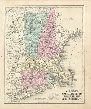
Colton's 1860 Map of Vermont, Massachusetts, Rhode Island, and Connecticut
Publication Date: 1860
Seller: Art Source International Inc., Boulder, CO, U.S.A.
Seller rating 5 out of 5 stars
This political map was issued as part of J.H. Coltons's 1860 School Atlas. We consider Colton to be the premier mapmaker in American history. His maps are known for their precision and attention to detail. This map measures 9.75 inches by 12 inches.
-
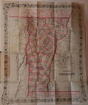
Colton's Map of Vermont
Published by New York, New York, 1866
Seller: Nicholas D. Riccio Rare Books, ABAA, Florham Park, NJ, U.S.A.
Seller rating 4 out of 5 stars

nbound, colored engraved map, decorative boarder, 16"x 13". Slight toning and aging, small chip in bottom margin, not affecting boarder or image; overall bright and clean and in very good condition. Maps are wrapped with acid free board, or in rigid sleeves. Beginning with J. H. Colton (1800-1893), the Colton family published atlases for over 30 years. Colton's Atlas of the World was first published in 1855 in a large two volume set. In 1857 it became Colton's General Atlas, and Colton's sons, George Woolworth and Charles B. would take over the business. This map of Vermont is probably from the 1866 edition of Colton's General Atlas, even though the copyright date on the map is 1855. The map is very colorful with a fair amount of detail on Vermont counties, and the Canadian boarder is visible at the top. May require extra postage. Ristow 313-326.
-
Colton's Map of Vermont and New Hampshire . Pocket Series, 1891.
Language: English
Seller: White Mountains, NH Books and Maps, Lincoln, NH, U.S.A.
Seller rating 5 out of 5 stars
No Binding. Condition: Near Fine. A very bright and colorful map, near fine condition in the original brown blind-stapmed bds with gilt titles. The map is folded within a HC book format. the book measures 3.75" x 6. the unfolded map measures approximately 23" x 29". Nice and large, very suitable for framing.
-
Colton's Map of Vermont
Published by G. W. & C. B. Colton & Co, New York, 1872
Seller: White Fox Rare Books and Antiques, ABAA/ILAB, New York, NY, U.S.A.
Association Member: ABAA ESA ILAB PBFA
Seller rating 4 out of 5 stars
Blindstamped Cloth. Condition: Very Good. Binding: 12.5 by 8.5 cm. Map opened up: 41 by 34 cm. Towns colored red, green, yellow or plain (color of paper). Floral vine border. Yellow front endpaper with Colton promotion. Condition: binding with some corner and edge wear, with a small ding, lower front corner. A few miniscule pinprick fabric losses on spine. Fold out map has light age toning but is in overall fine, or near fine, condition, with no tears, the colors fresh, etc. Yellow endpaper has some soiling, and a faded inscription written perpendicular to the printed text. Minor paper loss inside spine.
-
Colton's Rail-Road and Township Map of Vermont from County Maps and Actual Surveys.
Publication Date: 1868
Seller: Geographicus Rare Antique Maps, Brooklyn, NY, U.S.A.
Association Member: ABAA ESA ILAB
Seller rating 4 out of 5 stars
Map
Very good. Slight wear and toning on old fold lines. Minimal verso reinforcement at many fold intersections. Accompanies original gilt stamped binder. Size 38.75 x 28 Inches. A striking 1868 example of G. W. and C. B. Colton's 1868 pocket map of Vermont. The map is novel as Colton's only large-scale separate-issue map to focus exclusively on Vermont. It is also of interest for its illustration of the Vermont gold region - a little-known chapter in the state's history. A Closer Look Coverage embraces Vermont and adjacent parts of New York, Massachusetts, New Hampshire, and Canada. Coverage in New York is expanded to accommodate Lake Champlain, Lake George, and railroad links to the Hudson River. Vermont itself is divided into counties and subdivided into townships. Topography is emphasized with hachure, and major mountains are named, among them Stratton, Killington, and Mansfield (Stowe) - today popular ski resorts. In the lower right, a large inset, reduced from Colton's atlas map of New England, places Vermont within a regional context. Just south, across the border, the Hoosac Tunnel (Hoosic) is illustrated, though the tunnel was still under construction and would not open until 1875. Vermont's Gold Rush One of the more captivating aspects of this map is its treatment of the Vermont gold region. Gold mining in Vermont is a lesser-known chapter in the state's history. While Vermont isn't typically associated with significant gold discoveries, there were sporadic crazes. The primary period of interest occurred in the mid to late 19th century, around the time this map was issued. In the wake of the California Gold Rush, gold fever swept across the country, and even minor discoveries could result in minor rushes. When alluvial deposits were discovered in the Green Mountains, prospectors flocked to Vermont in hopes of striking it rich, particularly in Windsor County. Nonetheless, the overall yield of gold in Vermont was modest, and the mining activity rapidly waned as prospectors moved on to more lucrative areas. Today, historical remnants such as old mine shafts and equipment serve as reminders of Vermont's brief flirtation with gold. Publication History and Census This map was engraved and published in 1868 by Colton's Geographical Establishment under G. W. and C. B. Colton. The map is copyrighted to 1860, but we see no examples of that edition in any records. We do see an 1864 edition in 4 institutions and this 1868 edition in 3: Bennington Museum, Yale University, and the University of Missouri. References: OCLC 1422014813. Bennington Museum, 2007.124. Yale University, Beinecke Library, 8303857.
-
ORIGINAL 1855 COLTON'S HAND COLORED MAP OF VERMONT
Published by J. H. Colton & Co., 1855
Seller: Sage Rare & Collectible Books, IOBA, Livonia, MI, U.S.A.
Association Member: IOBA
Seller rating 5 out of 5 stars
Map
Map. Condition: Very Good+. Antique hand colored map is toned but clean and in very good condition. 18.5" x 16". Includes the seperate accompanying page of text about the region which can also be framed.
-
Colton's Railroad and Township Map of Massachusetts, Rhode Island, and Connecticut, with Parts of Maine, New Hampshire, Vermont, and New York.
Publication Date: 1873
Seller: Geographicus Rare Antique Maps, Brooklyn, NY, U.S.A.
Association Member: ABAA ESA ILAB
Seller rating 3 out of 5 stars

Map
Fair. Wear along original fold lines. Loss along fold lines and at fold intersections. Old repairs at fold intersections. Light toning. Printer's crease. Size 31.75 x 32.25 Inches. This is a rare 1873 G.W. and C.B. Colton railroad map of Massachusetts, Connecticut, and Rhode Island. A Closer Look Coverage embraces Massachusetts, Connecticut, and Rhode Island, most of Vermont and New Hampshire, and the lower half of Maine and eastern New York. Townships throughout are shaded and labeled. Cities, towns, and villages are identified, along with mountains and lakes. Black lines highlight the railroad network, from major routes to small regional railroads, almost all of which are named. An inset along the right border depicts New England and Canada from Bennington, Vermont, to Newfoundland, including the Canadian Maritimes. Publication History and Census This map was created by J.H. Colton and published by his sons, G.W. and C.B. Colton, in 1873. We note 4 examples of the 1873 edition cataloged in OCLC: Yale University, the Connecticut Museum of Culture and History, Harvard University, and the Boston Public Library. Also, we note cataloged examples of editions published in 1862, 1866, 1871, 1886, and 1890. Due to cataloging inconsistencies, some of these other editions may represent examples of the 1873. We note only a handful of instances in the last decade when examples of any edition of this map appeared on the private market. References: OCLC 57396467.