China by Augustus Mitchell (39 results)
 More images
Language: English
Published by [W.M. Bradley], [Philadelphia] 1886
Seller: Kaaterskill Books, ABAA/ILAB, East Jewett, NY, U.S.A.Kaaterskill Books, ABAA/ILAB
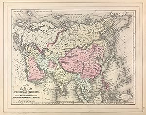
Contact seller5-star sellerHand colored map. Plate 115: Map of Asia Showing its Gt. Political Divisions, and also the Various Routes of Travel Between London & India, China & Japan &c, constructed & engraved by W. Williams, Philadelphia. Copyright by S. Augustus Mitchell 1884. 13.5 x 10.5 inches. [On verso] Plate 116: Map of Persia, Arabia, Turkey in Asia…, Afghanistan, Beloochistan. Copyright by S. Augustus Mitchell 1884. 13.5 x 10.5 inches. From: Mitchell's New General Atlas, Containing Maps Of The Various Countries Of The World, Plans Of Cities, Etc., Embraced In Ninety-Three Quarto Maps, Forming A Series Of One Hundred and Forty-seven Maps and Plans, Together With Valuable Statistical Tables. Also, A List Of Post-Offices Of The United States And Territories, And Also Census Of 1880 For States, Territories And Counties, Also Of Cities Of Over 10,000 Inhabitants. Philadelphia: Published By Wm. M. Bradley & Bro., No. 1026 Arch Street. 1886. Very good, light soiling, primarily to margins.
 More images
Language: English
Published by [W.M. Bradley], [Philadelphia] 1886
Seller: Kaaterskill Books, ABAA/ILAB, East Jewett, NY, U.S.A.Kaaterskill Books, ABAA/ILAB
Contact seller5-star sellerHand colored map. Plate 117: New Map of Palestine or the Holy Land [with inset] Map of Modern Jerusalem, drawn & engraved by W.H. Gamble, Philadelphia. Copyright by S. Augustus Mitchell 1884. 11.5 x 14 inches. [On verso] Plate 118: Map of Hindoostan, Farther India, China, and Tibet, constructed & engraved by W. Williams, Philade…lphia. Copyright by S. Augustus Mitchell 1884. 13.75 x 11.25 inches. From: Mitchell's New General Atlas, Containing Maps Of The Various Countries Of The World, Plans Of Cities, Etc., Embraced In Ninety-Three Quarto Maps, Forming A Series Of One Hundred and Forty-seven Maps and Plans, Together With Valuable Statistical Tables. Also, A List Of Post-Offices Of The United States And Territories, And Also Census Of 1880 For States, Territories And Counties, Also Of Cities Of Over 10,000 Inhabitants. Philadelphia: Published By Wm. M. Bradley & Bro., No. 1026 Arch Street. 1886. Very good, light soiling, primarily to margins, one edge tear, not affecting contents.

Published by Philadelphia c.1847, Philadelphia 1847
Seller: High Ridge Books, Inc. - ABAA, South Deerfield, MA, U.S.A.High Ridge Books, Inc. - ABAA
Contact seller5-star sellerMap of China from Mitchell's Universal Atlas. fine condition. Full color by region. Includes Korea. Hong Kong is named, with the note (To Great Britain). The capital of Korea is shown as Kingkitao (the name Seoul does not appear) which is the name of the province containing Seoul. This is removed from one of the latest issues of… Mitchell's atlas before publication was taken up by Thomas, Cowperthwait & Co. Map no. 70.

Published by Mitchell, S. Augustus, Philadelphia 1860
- Map
Seller: mediumraremaps.com, Franklin, TN, U.S.A.mediumraremaps.com
Contact seller5-star sellerCondition: Used - Very good
£ 42.23
£ 4.47 shippingShips within U.S.A.Quantity: 1 available
13 1/2 x 10 5/8 inches. Condition: Very good. 1860. An attractive map of Asia in a single page format from Mitchell's "New General Atlas." The map is hand-colored with definitive border separation from Europe. The travel notations shows London to Madras at 8,000 miles; London to Hong Kong at 10,800 miles. The all water route fro…m London to the Far East has a complementary land-water route. The water route shows the Suez land bridge being used. Suez Canal was under construction starting April 25, 1859. It was completed on November 17, 1869 at which time the map would show the same distance.

Seller: Art Source International Inc., Boulder, CO, U.S.A.Art Source International Inc.
Contact seller5-star sellerThis map of Asia was made by S. Augustus Mitchell for "Mitchells New General Atlas" published in 1888, by WM. M. Bradley & Co. The well maintained maps in this atlas feature Mitchell's characteristic pastel coloring and abundant details of geographical features. Details include the names of countries, cities, towns, railroads, t…ransportation routes, mountain ranges, rivers and lakes. These 1888 maps offer a fascinating perspective of areas that have since undergone significant growth and change, in addition to their value as great examples of Mitchell's work. This map measures 13.5 inches by 10.5 inches.

Seller: Art Source International Inc., Boulder, CO, U.S.A.Art Source International Inc.
Contact seller5-star sellerS. Augustus Mitchell Jr. made this hand colored map for "Mitchells New General Atlas" in 1872. Asia is illustrated on this map. Regions are distinguished by bright pastel colors. Lakes, mountains, rivers, important cities and countries are identified, as well as major travel routes between various locations and points in Asia. T…his map measures 13 inches by 10.5 inches.

Seller: Art Source International Inc., Boulder, CO, U.S.A.Art Source International Inc.
Contact seller5-star sellerThis map of Asia came from Mitchells New General Atlas, 1881. Major railroads, bodies of water, cities and towns, geographic features, and Mitchell's distinctive ivy border are shown on this map. This map measures 13.5 inches by 11 inches.

Seller: Art Source International Inc., Boulder, CO, U.S.A.Art Source International Inc.
Contact seller5-star sellerS. Augustus Mitchell Jr. made this hand colored map in 1872. Hindoostan, farther India, China and Tibet are illustrated on this map. Regions are distinguished by bright pastel colors. Deserts, lakes, mountains, rivers, important cities and countries are identified. This map measures 13 inches by 10.5 inches.

Seller: Art Source International Inc., Boulder, CO, U.S.A.Art Source International Inc.
Contact seller5-star sellerThis map was made by S. Augustus Mitchell for "Mitchells New General Atlas" published in 1884, by WM. M. Bradley & Co. The well maintained maps in this atlas feature Mitchell's characteristic pastel coloring and abundant geographical features. Details include the names of countries, regions, cities, towns, transportation routes,… rivers, lakes, and mountain ranges. Regions are distinguished by color. These 1884 maps offer a fascinating perspective of areas that have since undergone significant growth and change, in addition to their value as great examples of Mitchell's work. This map measures 14 inches by 11.25 inches.

Seller: Art Source International Inc., Boulder, CO, U.S.A.Art Source International Inc.
Contact seller5-star sellerThis map was produced by Augustus Mitchell in 1878 for his New General Atlas. Highlights of this map are Mitchells traditional grapevine border, characteristic pastel coloring and abundant details of geographical features. This map of Asia shows the political divisions as well as routes of travel between the Eastern countries. C…ountries are distinguished by color. This 1878 map offers a fascinating perspective of areas that have since undergone significant growth and change, in addition to the value as great examples of Mitchell's classic mapmaking style. This map measures 13.5 inches by 10.5 inches.

Seller: Art Source International Inc., Boulder, CO, U.S.A.Art Source International Inc.
Contact seller5-star sellerThis map of Asia was produced by Augustus Mitchell in 1879 for his New General Atlas. Highlights of this map are Mitchells traditional grapevine border, characteristic pastel coloring and abundant details of geographical features. This 1879 map offers a fascinating perspective of areas that have since undergone significant growt…h and change, in addition to the value as great examples of Mitchell's classic map-making style. This map measures 13.5 inches by 10.75 inches.

Seller: Art Source International Inc., Boulder, CO, U.S.A.Art Source International Inc.
Contact seller5-star sellerThis map was made by S. Augustus Mitchell for "Mitchell's New General Atlas" published in 1887. The well maintained maps in this atlas feature Mitchell's characteristic pastel coloring and abundant details of geographical features. Hindoostan, Farther India, China and Tibet are illustrated on this map. Details include the names…of regions, important towns, rivers, lakes, mountain ranges and railroads. Regions are distinguished by color. These 1887 maps offer a fascinating perspective of areas that have since undergone significant growth and change, in addition to their value as great examples of Mitchell's work. This map measures 14 inches by 11.25 inches.

Seller: Art Source International Inc., Boulder, CO, U.S.A.Art Source International Inc.
Contact seller5-star sellerThis map of Hindoostan, Farther India, China, and Tibet was made by S. Augustus Mitchell for "Mitchells New General Atlas" published in 1888, by WM. M. Bradley & Co. The well maintained maps in this atlas feature Mitchell's characteristic pastel coloring and abundant details of geographical features. Details include the names of… countries, cities, towns, transportation routes, mountain ranges, rivers, lakes, bays and seas. These 1888 maps offer a fascinating perspective of areas that have since undergone significant growth and change, in addition to their value as great examples of Mitchell's work. This map measures 14 inches by 11.25 inches.

Seller: Art Source International Inc., Boulder, CO, U.S.A.Art Source International Inc.
Contact seller5-star sellerThe Mitchell company was one of the first to try out the new technique of engraving on steel plates, experimenting with steel almost 20 years before the rest of the publishing industry. He was printing with steel in the early 1830s; the general switch to steel was approximately 1850. During the early years of the company, Mitche…ll published mainly maps and travel guides. In 1860, Mitchell started producing "Mitchell's New General Atlas", and Mitchell Sr. retired and turned the business over to his son of the same name. The New General Atlas was published until 1893. Today Mitchell maps are sought after for their fine engraving, bright coloring, and attention to detail. They are some of the finest maps produced in the 1860's. This map produced in 1867, has Mitchell's unique floral border, and beautiful hand coloring. This map details Hindoostan, Farther India, China and Tibet. Countries, cities, rivers and mountain ranges are illustrated. This map measures 13 inches by 10 inches.

Seller: Art Source International Inc., Boulder, CO, U.S.A.Art Source International Inc.
Contact seller5-star sellerThe Mitchell company was one of the first to try out the new technique of engraving on steel plates experimenting with steel almost 20 years before the rest of the publishing industry. He was printing with steel in the early 1830s; the general switch to steel was approximately 1850. During the early years of the company, Mitchel…l published mainly maps and travel guides. In 1860, Mitchell started producing "Mitchell's New General Atlas",and Mitchell Sr. retired and turned the business over to his sonof the same name. The New General Atlas was published until1893. Today Mitchell maps are sought after for their fine engraving, bright coloring, and attention to detail. They aresome of the finest maps produced during this time period. This map produced in 1866, has Mitchell's unique floral border, and beautiful hand coloring. This map details Asia and its political subdivisions. Countries, cities, towns, lakes, rivers, mountains, and transportation routes are noted. Each map was printed on thick paper with vibrant hand color. This map measures 13.5 inches by 10.5 inches.

Seller: Art Source International Inc., Boulder, CO, U.S.A.Art Source International Inc.
Contact seller5-star sellerThe Mitchell company was one of the first to try out the new technique of engraving on steel plates, experimenting with steel almost 20 years before the rest of the publishing industry. He was printing with steel in the early 1830s; the general switch to steel engraving was approximately 1850. During the early years of the compa…ny, Mitchell published mainly maps and travel guides. In 1860, Mitchell started producing "Mitchell's New General Atlas". Mitchell Sr. retired and turned the business over to his son of the same name. The New General Atlas was published until 1893. Today Mitchell maps are sought after for their fine engraving, bright coloring, and attention to detail. They are some of the finest maps produced in the 1860's. This map, produced in 1863, shows Mitchell's famous flower border, which is only seen in the early editions of his atlases. This map shows Hindostan, Farther India, China, and Tibet. This map measures 14.5 inches by 12 inches.

Seller: Art Source International Inc., Boulder, CO, U.S.A.Art Source International Inc.
Contact seller5-star sellerThis map was made by S. Augustus Mitchell for "Mitchells New General Atlas," published by WM. M. Bradley & Co, 1885. This well-maintained example features Mitchell's characteristic pastel coloring and abundant geographical detail. Hindoostan, Farther India, China and Tibet are illustrated including political divisions, cities an…d towns, rivers, and topographic features. This map measures 10 inches by 13 inches.

Seller: Art Source International Inc., Boulder, CO, U.S.A.Art Source International Inc.
Contact seller5-star sellerThis map was produced by S. Augustus Mitchell in 1874 for his New General Atlas. This map shows Mitchells traditional grape vine border, characteristic pastel coloring and abundant details of geographical features. Hindoostan, Farther India, China and Tibet are illustrated on this map. Countries are distinguished by color. These… 1874 maps offer a fascinating perspective of areas that have since undergone significant growth and change, in addition to their value as great examples of Mitchell's work. This map measures 14 inches by 11 inches.

Seller: Art Source International Inc., Boulder, CO, U.S.A.Art Source International Inc.
Contact seller5-star sellerThe Mitchell company was one of the first to try out the new technique of engraving on steel plates, experimenting with steel almost 20 years before the rest of the publishing industry. He was printing with steel in the early 1830s; the general switch to steel engraving was approximately 1850. During the early years of the compa…ny, Mitchell published mainly maps and travel guides. In 1860, Mitchell started producing "Mitchell's New General Atlas". Mitchell Sr. retired and turned the business over to his son of the same name. The New General Atlas was published until 1893. Today Mitchell maps are sought after for their fine engraving, bright coloring, and attention to detail. They are some of the finest maps produced in the 1860's. This map, produced in 1863, shows Mitchell's famous flower border, which is only seen in the early editions of his atlases. This map shows Asia. This map measures 14 inches by 11 inches.

Seller: Art Source International Inc., Boulder, CO, U.S.A.Art Source International Inc.
Contact seller5-star sellerThis map of Hindoostan, Farther India, China, and Tibet was produced by Augustus Mitchell in 1879 for his New General Atlas. Highlights of this map are Mitchells traditional grapevine border, characteristic pastel coloring and abundant details of geographical features. This 1879 map offers a fascinating perspective of areas that… have since undergone significant growth and change, in addition to the value as great examples of Mitchell's classic map-making style. This map measures 14.25 inches by 11.5 inches.

Seller: Art Source International Inc., Boulder, CO, U.S.A.Art Source International Inc.
Contact seller5-star sellerIn 1860 S. Augustus Mitchell Jr. took over his father's map publishing business and in that year he started publishing Mitchell's New General Atlas. Editions of the new general were issued annually until 1887. Mitchell Jr. continued publishing this atlas until 1879. The editions from 1880 to 1887 were published by Wm. M. Bradley…. This map published in 1865 is a wonderful example of Mitchell's map-making prowess with beautiful original hand-coloring. This map measures 13.5 inches by 10.5 inches.

Seller: Art Source International Inc., Boulder, CO, U.S.A.Art Source International Inc.
Contact seller5-star sellerThe Mitchell company was one of the first to try out the new technique of engraving on steel plates, experimenting with steel almost 20 years before the rest of the publishing industry. He was printing with steel in the early 1830s; the general switch to steel was approximately 1850. During the early years of the company, Mitche…ll published mainly maps and travel guides. In 1860, Mitchell started producing "Mitchell's New General Atlas",and Mitchell Sr. retired and turned the business over to his son of the same name. The New General Atlas was published until 1893. Today Mitchell maps are sought after for their fine engraving, bright coloring, and attention to detail. They are some of the finest maps produced in the 1860's. This map produced in 1867, has Mitchell's unique floral border, and beautiful hand coloring. This map details Asia, showing its political divisions. Countries, cities, transportation routes and some topographical features are illustrated. This map measures 13.5 inches by 10 inches.

Seller: Art Source International Inc., Boulder, CO, U.S.A.Art Source International Inc.
Contact seller5-star sellerS. Augustus Mitchell Jr. made this hand colored map for Mitchells New General Atlas in 1870. Regions are distinguished by bright pastel colors. This map measures 14 inches by 11 inches.

Seller: Art Source International Inc., Boulder, CO, U.S.A.Art Source International Inc.
Contact seller5-star sellerWith characteristic floral boarders and beautiful, muted pastel coloring, these 1864 maps are fantastic examples of Mitchells work. Regions, important cities, rivers, lakes, and railroads are identified. India, China and Tibet are illustrated on this hand colored map. This map measures 13.75 inches by 11.25 inches.

Seller: Art Source International Inc., Boulder, CO, U.S.A.Art Source International Inc.
Contact seller5-star sellerThis hand colored map was made by S. Augustus Mitchell, Jr. for "Mitchells New General Atlas" in 1868. Hindostan, Farther India, China, and Tibet are illustrated on this map. Countries and regions are differentiated by color. Other details include the names of countries, and important cities. Illustrations of rivers, lakes, majo…r roads, and mountains are provided. This atlas has very beautiful coloring-more muted than typical. This map measures 14 inches by 11.5 inches.

Seller: Art Source International Inc., Boulder, CO, U.S.A.Art Source International Inc.
Contact seller5-star sellerThis map was produced by S. Augustus Mitchell in 1875 for his New General Atlas. This map shows Mitchells traditional grape vine border, characteristic pastel coloring and abundant details of geographical features. Counties are distinguished by different colors. Wagon trails and major routes of transport are also shown. These 18…75 maps offer a fascinating perspective of areas that have since undergone significant growth and change, in addition to their value as great examples of Mitchell's work. This map measures 14 inches by 11 inches.

Seller: Art Source International Inc., Boulder, CO, U.S.A.Art Source International Inc.
Contact seller5-star sellerThe Mitchell company was one of the first to try out the new technique of engraving on steel plates experimenting with steel almost 20 years before the rest of the publishing industry. He was printing with steel in the early 1830s; the general switch to steel was approximately 1850. During the early years of the company, Mitchel…l published mainly maps and travel guides. In 1860, Mitchell started producing "Mitchell's New General Atlas",and Mitchell Sr. retired and turned the business over to his sonof the same name. The New General Atlas was published until1893. Today Mitchell maps are sought after for their fine engraving, bright coloring, and attention to detail. They aresome of the finest maps produced during this time period. This map produced in 1866, has Mitchell's unique floral border, and beautiful hand coloring. This map details Hindoostan, Farther India, China, and Tibet. Countries, cities, towns, lakes, rivers, mountains, and transportation routes are noted. Each map was printed on thick paper with vibrant hand color. This map measures 13.75 inches by 11 inches.

Published by Philadelphia 1846
- First Edition
- Art Print
Seller: Trillium Antique Prints & Rare Books, Franklin, TN, U.S.A.Trillium Antique Prints & Rare Books
Contact seller2-star sellerCondition: Fine. 1st Edition. This hand-colored map is from Samuel Augustus Mitchell's "A New Universal Atlas Containing Maps of the various Empires, Kingdoms, States and Republics of the World. With a special map of each of the United States, Plans of Cities &c". The work was published in Philadelphia by the Author in 1846. ---… Samuel Augustus Mitchell (1792-1868) and his sons were leading map publishers in the United States in the 19th century. Mitchell moved to Philadelphia c1830 in the hopes to improve geography textbooks and American cartographical information. He acquired the rights to Tanner's "New Universal Atlas" (first published in 1836), and issued his first printing of the work in 1846. --- The work is in very good to excellent condition overall. There may be some light toning or spotting to the plates. There may be a few minor imperfections or faint marks to be expected with age. Please review the image carefully for condition and contact us with any questions. --- Paper Size ~ 14" by 17 1/2".

Seller: Art Source International Inc., Boulder, CO, U.S.A.Art Source International Inc.
Contact seller5-star sellerIn 1860 S. Augustus Mitchell Jr. took over his father's map publishing business and in that year he started publishing Mitchell's New General Atlas. Editions of the new general were issued annually until 1887. Mitchell Jr. continued publishing this atlas until 1879. The editions from 1880 to 1887 were published by Wm. M. Bradley…. This map published in 1865 is a wonderful example of Mitchell's map-making prowess with beautiful original hand-coloring. This map measures 13.5 inches by 10.5 inches.

Seller: Art Source International Inc., Boulder, CO, U.S.A.Art Source International Inc.
Contact seller5-star sellerThis beautiful map of Asia was made by S. Augustus Mitchell, in 1860, for his New General Atlas. This map features bright original hand coloring that differentiates regions and country sections, a decorative floral border, and fine detailing (including countries, cities, rivers, and lakes). This map measures 13.25 inches by 10.5… inches.


