
Order Total (1 Item Items):
Shipping Destination:

Chart World Mercators Projection Shewing by Stanford Edward (9 results)
Feedback
Skip to main search results
Search filters
Product Type
- All Product Types
- Books (1)
- Magazines & Periodicals (No further results match this refinement)
- Comics (No further results match this refinement)
- Sheet Music (No further results match this refinement)
- Art, Prints & Posters (No further results match this refinement)
- Photographs (No further results match this refinement)
- Maps (8)
- Manuscripts & Paper Collectibles (No further results match this refinement)
Condition Learn more
- New (No further results match this refinement)
- As New, Fine or Near Fine (No further results match this refinement)
- Very Good or Good (5)
- Fair or Poor (1)
- As Described (3)
Binding
Collectible Attributes
- First Edition (No further results match this refinement)
- Signed (No further results match this refinement)
- Dust Jacket (No further results match this refinement)
- Seller-Supplied Images (9)
- Not Print on Demand (9)
Language (1)
Price
- Any Price
- Under � 20 (No further results match this refinement)
- � 20 to � 35 (No further results match this refinement)
- Over � 35
Free Shipping
- Free Shipping to United Kingdom (No further results match this refinement)
Seller Location
Seller Rating
-

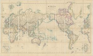
A Chart of the World on Mercator's Projection Shewing the principal Ocean Steam Routes, the Submarine Telegraphs &c.
Published by LondonEdward Stanford 55 Charing Cross Jan. 1st ., 1885
Seller: Robert Frew Ltd. ABA ILAB, London, United Kingdom
Association Member: ABA ILAB PBFA
Seller rating 4 out of 5 stars

Map
Original engraved map of the world (69.5 x 103.5 cm) with outline colour, dissected into 40 panels and laid onto linen, two panels with marbled endpapers, folding into original brown cloth slipcase with publisher's yellow title label to upper portion. The map recording steam routes including travel times and underwater telegraph cables; map inserts of the Arctic and Antarctica (polar projection) in lower right and lower left quadrants. Generally an excellent, well preserved copy. Edward Stanford, Fellow of the Royal Geographical Society, acquired the plates and stock of John Arrowsmith in 1874.
-
A Chart of the World on Mercator's Projection Shewing the principal Ocean Steam Routes, the Submarine Telegraphs &c.
Published by LondonEdward Stanford 55 Charing Cross June 1st ., 1881
Seller: Robert Frew Ltd. ABA ILAB, London, United Kingdom
Association Member: ABA ILAB PBFA
Seller rating 4 out of 5 stars
Map
Original engraved map of the world (69.5 x 103.5 cm) with outline colour, dissected into 40 panels and laid onto linen, two panels with marbled endpapers, folding into original brown cloth slipcase with publisher's yellow title label to upper portion. The map recording steam routes including travel times and underwater telegraph cables; map inserts of the Arctic and Antarctica (polar projection) in lower right and lower left quadrants. Some occasional light soiling, generally an excellent example. Edward Stanford, Fellow of the Royal Geographical Society, acquired the plates and stock of John Arrowsmith in 1874.
-

A Chart of the World on Mercator's Projection Shewing the Principal Ocean Steam Routes, the Submarine Telegraph &c
Published by Edward Stanford, London, 1881
Map
� 3,603.05
Convert currency� 25.91 shipping from U.S.A. to United KingdomQuantity: 1 available
Add to basketNo binding. Condition: Very good. London: Edward Stanford, 1881. Engraved case map of the world in 40 segments (26 � x 44 � inches) mounted to original linen backing with promotional self-wrappers ("Stanford's Two-Shilling Series of Tourists Guides / New Maps and New Editions"), recording steam routes including travel times and underwater telegraph cables; map inserts of the Arctic and Antarctica (polar projection) in lower right and lower left quadrants. Condition: very good with original color in outline; small creasing in lower right corner and some isolated foxing. Edward Stanford, Fellow of the Royal Geographical Society, acquired the plates and stock of John Arrowsmith in 1874. Note some scattered annotations regarding the achievements of 19th century naval officers and explorers that Stanford added to the present map, including the mention of William Parry's (1790-1855) attempt on the North Pole from the northern shores of Spitsbergen in 1827 (recorded beyond the neatline of the present map).
-
A Chart of the World on Mercator's Projection, Shewing the Principal Ocean Steam Routes, The Submarine Telegraphs, &c
Published by London, 1885
Seller: Argosy Book Store, ABAA, ILAB, New York, NY, U.S.A.
Seller rating 5 out of 5 stars

� 762.55
Convert currency� 31.09 shipping from U.S.A. to United KingdomQuantity: 1 available
Add to basketCase Map. Lithograph. Sheet measures 44 1/4" x 27 5/8". Comes with brown slip case that measures 4 3/4" x 7". Wonderful world map centered on the Pacific Ocean, highlighting steam ship routes. The western most countries of Europe and Africa appear on both the left right and right sides of the composition in order to show the steam ship routes and undersea telegraph cables in their entirety. Two inset maps in the bottom corners show the Arctic and Antarctic regions. Edward Stanford (1827-1904) was an English mapmaker and publisher, and the founder of a map and globe company that still flourishes today. After a brief partnership with T.W. Saunders as Saunders & Stanford from 1852-1853, Stanford established his own firm by 1854. Collaborating with his former partner Saunders, and the Edinburgh publishing family of A.K. Johnston, he grew to become one of the major map and atlas compilers of the 19th century, using maps acquired from the Society for the Diffusion of Knowledge, and later from John Arrowsmith among other sources. Many of his publications were for official bodies such as the Ordnance Survey, Admiralty, Geological Survey, Trigonometrical Survey of India, the Royal Geographical Society, the School Board of London, and many more. In the 1880s, his son Edward Jr. took over leadership of the firm. Stanfords still exists today in London and Bristol, and its collection of maps, globes, and maritime charts is considered the largest in the world.
-
![Seller image for A Chart of the World on Mercator's Projection shewing the principal Ocean Steam Routes, the Submarine Telegraphs, &c. [West Sheet] for sale by Antiqua Print Gallery](https://pictures.abebooks.com/inventory/md/md32202109463.jpg)
A Chart of the World on Mercator's Projection shewing the principal Ocean Steam Routes, the Submarine Telegraphs, &c. [West Sheet]
Publication Date: 1904
Map
Condition: Good. World on Mercator's Projection. West sheet. Americas. 67x55cm. STANFORD 1904 map. Large (folio) antique atlas map; Stanford's Geographical Establishment (1904). 67.0 x 55.0cm, 26.25 x 21.75 inches; this is a folding map. Condition: Good. The image shown may have been taken from a different example of this map than that which is offered for sale. The map you will receive is in good condition but there may be minor variations in the condition from that shown in the image. There is nothing printed on the reverse side, which is plain.
-
![Seller image for A Chart of the World on Mercator's Projection shewing the principal Ocean Steam Routes, the Submarine Telegraphs, &c. [West Sheet] for sale by Antiqua Print Gallery](https://pictures.abebooks.com/inventory/md/md31387519181.jpg)
A Chart of the World on Mercator's Projection shewing the principal Ocean Steam Routes, the Submarine Telegraphs, &c. [West Sheet]
Publication Date: 1904
Map
Condition: Poor. World on Mercator's Projection. West sheet. Americas. 67x55cm. STANFORD 1904 map. Large (folio) antique atlas map; Stanford's Geographical Establishment (1904). 67.0 x 55.0cm, 26.25 x 21.75 inches; this is a folding map. Condition: Poor: Spotting; Partial splits along fold. Untidy. If the print has been scanned in black and white, any foxing or spotting highlighted in this statement may appear brown on the actual print. There is nothing printed on the reverse side, which is plain.
-
![Seller image for A Chart of the World on Mercator's Projection shewing the principal Ocean Steam Routes, the Submarine Telegraphs, &c. [West Sheet] for sale by Antiqua Print Gallery](https://pictures.abebooks.com/inventory/md/md31759128785.jpg)
A Chart of the World on Mercator's Projection shewing the principal Ocean Steam Routes, the Submarine Telegraphs, &c. [West Sheet]
Publication Date: 1896
Map
Condition: Good. World on Mercator's Projection. West sheet. Americas. 67x55cm. STANFORD 1896 map. Large (folio) antique atlas map; Stanford's Geographical Establishment (1896). 67.5 x 55.5cm, 26.5 x 21.75 inches; this is a folding map. Condition: Good. The image shown may have been taken from a different example of this map than that which is offered for sale. The map you will receive is in good condition but there may be minor variations in the condition from that shown in the image. There is nothing printed on the reverse side, which is plain.
-
![Seller image for [A Chart of the World on Mercator's Projection shewing the principal Ocean Steam Routes, the Submarine Telegraphs, &c.] The World, East for sale by Antiqua Print Gallery](https://pictures.abebooks.com/inventory/md/md32202115036.jpg)
[A Chart of the World on Mercator's Projection shewing the principal Ocean Steam Routes, the Submarine Telegraphs, &c.] The World, East
Publication Date: 1904
Map
Condition: Good. World on Mercator's Projection. East sheet. Europe Asia Africa STANFORD 1904 map. Large (folio) antique atlas map; Stanford's Geographical Establishment (1904). 67.0 x 55.0cm, 26.25 x 21.75 inches; this is a folding map. Condition: Good. The image shown may have been taken from a different example of this map than that which is offered for sale. The map you will receive is in good condition but there may be minor variations in the condition from that shown in the image. There is nothing printed on the reverse side, which is plain.
-
![Seller image for [A Chart of the World on Mercator's Projection shewing the principal Ocean Steam Routes, the Submarine Telegraphs, &c.] The World, East for sale by Antiqua Print Gallery](https://pictures.abebooks.com/inventory/md/md31759139908.jpg)
[A Chart of the World on Mercator's Projection shewing the principal Ocean Steam Routes, the Submarine Telegraphs, &c.] The World, East
Publication Date: 1896
Map
Condition: Good. World on Mercator's Projection. East sheet. Europe Asia Africa STANFORD 1896 map. Large (folio) antique atlas map; Stanford's Geographical Establishment (1896). 66.0 x 55.5cm, 26 x 21.75 inches; this is a folding map. Condition: Good. The image shown may have been taken from a different example of this map than that which is offered for sale. The map you will receive is in good condition but there may be minor variations in the condition from that shown in the image. There is nothing printed on the reverse side, which is plain.
