
Order Total (1 Item Items):
Shipping Destination:

Carte Lisle Java by Bellin Jacques Nicolas (5 results)
Skip to main search results
Search filters
Product Type
- All Product Types
- Books (1)
- Magazines & Periodicals (No further results match this refinement)
- Comics (No further results match this refinement)
- Sheet Music (No further results match this refinement)
- Art, Prints & Posters (No further results match this refinement)
- Photographs (No further results match this refinement)
- Maps (4)
- Manuscripts & Paper Collectibles (No further results match this refinement)
Condition Learn more
- New (No further results match this refinement)
- As New, Fine or Near Fine (No further results match this refinement)
- Very Good or Good (No further results match this refinement)
- Fair or Poor (No further results match this refinement)
- As Described (5)
Binding
- All Bindings
- Hardcover (No further results match this refinement)
- Softcover (No further results match this refinement)
Collectible Attributes
- First Edition (No further results match this refinement)
- Signed (No further results match this refinement)
- Dust Jacket (No further results match this refinement)
- Seller-Supplied Images (5)
- Not Print on Demand (5)
Language (2)
Price
- Any Price
- Under � 20 (No further results match this refinement)
- � 20 to � 35 (No further results match this refinement)
- Over � 35
Free Shipping
- Free Shipping to U.S.A. (No further results match this refinement)
Seller Location
Seller Rating
-

"Nouvelle Carte de l'Isle de Java" - Java island Indonesia
Language: French
Published by Den Haag, Pieter de Hondt, 1763
Seller: Antiquariat Steffen V�lkel GmbH, Seubersdorf, Germany
Seller rating 5 out of 5 stars

Map
Blatt-Ma�e: ca. 28 x 46 cm. -- Kupferstich von 1763. -- gut erhalten. || Copper engraving from 1763. -- in very good condition. // Wir, das Antiquariat Steffen V�lkel, kaufen und verkaufen alte B�cher, Handschriften, Zeichnungen, Autographen, Grafiken und Fotografien. Wir sind stets am Ankauf von kompletten Bibliotheken, Sammlungen und Nachl�ssen interessiert. Sprache: Franz�sisch Gewicht in Gramm: 10.
-

"Nouvelle Carte de l'Isle de Java" - Java island Indonesia
Language: French
Published by Den Haag, Pieter de Hondt, 1763
Seller: Antiquariat Steffen V�lkel GmbH, Seubersdorf, Germany
Seller rating 5 out of 5 stars
Map
Blatt-Ma�e: ca. 28 x 46 cm. -- Kupferstich von 1763. -- gut erhalten. || Copper engraving from 1763. -- in very good condition. // Wir, das Antiquariat Steffen V�lkel, kaufen und verkaufen alte B�cher, Handschriften, Zeichnungen, Autographen, Grafiken und Fotografien. Wir sind stets am Ankauf von kompletten Bibliotheken, Sammlungen und Nachl�ssen interessiert. Sprache: Franz�sisch Gewicht in Gramm: 10.
-
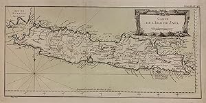
Carte de L'Isle de Java
Published by Jacques Nicolas Bellin, Paris, 1764
Seller: Argosy Book Store, ABAA, ILAB, New York, NY, U.S.A.
Seller rating 5 out of 5 stars
Engraving with original hand-colored. Image measures 7 3/4" x 16 3/8". Sheet measures 12 3/8" x 18 7/8" This 1764 map shows the Indonesian island of Java. A decorative title cartouche in the upper right is adorned with images of mountains, showing the volcanic terrain on the island. Towns, provinces, topographical features, and coastal features are labeled extensively. Mountains are depicted pictorially. Extends from the southern tip of the island of Sumatra, to the Island of Bali. The Island of Madura is also featured. The map is a dark impression in very good condition. Jacques Nicolas Bellin (1703-1772) was the official hydrographer to the French king and the first person to hold the title of "Ingenieur de la Marine of the Depot des cartes et plans de la Marine" (chief engineer of the French Hydrographical Office). He was particularly well known for his maps of the French Empire, especially the territories in North America. This map is a fine example of his detailed work.
-

Carte de l'isle de Java
Published by Paris, 1764
Seller: Alexandre Antique Prints, Maps & Books, Toronto, ON, Canada
Seller rating 4 out of 5 stars

Map
Size : 214x432 (mm), 8.375x17 (Inches), Original Hand Coloring Excellent; some minor age toning.
-

1761 Nouvelle Carte De lIsle De Java
Seller: New World Cartographic, Chicago, IL, U.S.A.
Seller rating 4 out of 5 stars
Map
Nouvelle Carte De lIsle De Java Dressee suivant les Observations les plus r�centes faites par ordre de la Comp. Holl. des Indes OrientalesBy: Jacques Nicolas BellinDate: 1761 (published) ParisDimensions: 8.6 x 17.25 inches (22 x 44 cm)This is a lovely map of the island of Java with parts of Sumatra, Madura, and Bali by Jacques Nicolas Bellin. According to its title, it depicts the most recent discoveries and observations of the region in Bellin's time. The map was ordered by the Dutch East India Company, thus the map's name below the image is in Dutch, while the title in the decorative cartouche is in French.The map is highly detailed, with pictorial representation of topography along with written descriptions. Toponyms name cities, ports, bays and all the provinces into which Java was divided at the time. Depth soundings are provided for all shorelines of each island. A compass rose from which rhumb lines radiate indicates that the map is oriented north.The Dutch East India Company was founded in 1602 to help the Dutch in their war with Spain, and to organize and control to the extent possible their maritime trade in the area of the Indian Ocean. The company was prosperous for nearly two hundred years and played an important role in Dutch trade in the East Indies till it was dissolved at the end of the 18th century.Condition: This map is in A condition on clean hand-laid paper with full margins.Inventory #126871200 West 35th Street, #425, Chicago, IL 60609| Phone: (312) 496 - 3622.