
Order Total (1 Item Items):
Shipping Destination:

Carte Isles Java Sumatra Borneo by Bellin (8 results)
Feedback
Skip to main search results
Search filters
Product Type
- All Product Types
- Books (1)
- Magazines & Periodicals (No further results match this refinement)
- Comics (No further results match this refinement)
- Sheet Music (No further results match this refinement)
- Art, Prints & Posters (No further results match this refinement)
- Photographs (No further results match this refinement)
- Maps (7)
- Manuscripts & Paper Collectibles (No further results match this refinement)
Condition Learn more
- New (No further results match this refinement)
- As New, Fine or Near Fine (1)
- Very Good or Good (2)
- Fair or Poor (No further results match this refinement)
- As Described (5)
Binding
- All Bindings
- Hardcover (No further results match this refinement)
- Softcover (No further results match this refinement)
Collectible Attributes
- First Edition (1)
- Signed (No further results match this refinement)
- Dust Jacket (No further results match this refinement)
- Seller-Supplied Images (8)
- Not Print on Demand (8)
Language (2)
Price
- Any Price
- Under � 20 (No further results match this refinement)
- � 20 to � 35 (No further results match this refinement)
- Over � 35
Free Shipping
- Free Shipping to United Kingdom (No further results match this refinement)
Seller Location
Seller Rating
-

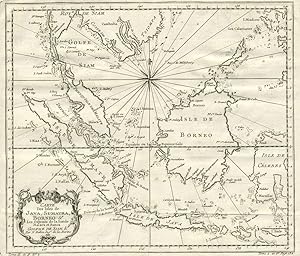
"Carte des Isles de Java, Sumatra, Borneo" - Borneo Java Malaysia Singapore Indonesia Indonesien Singapur Asia Asie Asien
Published by Paris, 1750
Language: French
Seller: Antiquariat Steffen V�lkel GmbH, Seubersdorf, Germany
Seller rating 5 out of 5 stars

Map
� 62.58
Convert currency� 24.31 shipping from Germany to United KingdomQuantity: 1 available
Add to basketOriginalKupferstich-Karte von Bellin von ca. 1750 - Blattmasse ca.27 x 32 cm - am linken Rand teils anger�ndert, nur leicht fleckig, sonst gut erhalten | original copper engraved map by Bellin from around 1750 - partly backed on the left margin, only slightly stained, otherwise in very good condition. Wir kaufen und verkaufen alte B�cher, Handschriften, Zeichnungen, Autographen, Grafiken und Fotografien. Wir sind stets am Ankauf von kompletten Bibliotheken, Sammlungen und Nachl�ssen interessiert. Sprache: Franz�sisch Gewicht in Gramm: 10.
-

"Carte des Isles de Java, Sumatra, Borneo" - Borneo Java Malaysia Singapore Indonesia Indonesien Singapur Asia Asie Asien
Published by Paris, 1750
Language: French
Seller: Antiquariat Steffen V�lkel GmbH, Seubersdorf, Germany
Seller rating 5 out of 5 stars
Map
� 62.58
Convert currency� 24.31 shipping from Germany to United KingdomQuantity: 1 available
Add to basketOriginalKupferstich-Karte von Bellin von ca. 1750 - Blattmasse ca.27,5 x 33 cm - gut erhalten | original copper engraved map by Bellin from around 1750 - in very good condition. Wir kaufen und verkaufen alte B�cher, Handschriften, Zeichnungen, Autographen, Grafiken und Fotografien. Wir sind stets am Ankauf von kompletten Bibliotheken, Sammlungen und Nachl�ssen interessiert. Sprache: Franz�sisch Gewicht in Gramm: 10.
-

Carte Des Isles de Java Sumatra Borneo
Published by Paris, 1744
Seller: Alexandre Antique Prints, Maps & Books, Toronto, ON, Canada
Seller rating 5 out of 5 stars
Map
� 190.84
Convert currency� 6.30 shipping from Canada to United KingdomQuantity: 1 available
Add to basketCondition: Excellent. Fine French map of South East Asia., Size : 255x300 (mm), 10x11.75 (Inches), Hand Colored in Outline.
-

Carte Des Isles de Java, Sumatra, Borneo & Les Detroits de la Sonde Malaca et Banca
Published by Bellini, 1760
Map
� 229.01
Convert currency� 23.35 shipping from Uruguay to United KingdomQuantity: 1 available
Add to basketSin Encuadernar. Condition: Muy bien. Detailed map of the Malaysian peninsula, Borneo and Indonesia, from L'Histoire Generale des Voyages. With title cartouche at lower left and great detail on the Indonesian islands, including the names of cities and harbors. At bottom left corner "Tome II in 4, no. 2; at the lower right "Tome 4 in 8. Page 132". Uncolored, with compass rose.
-
Carte Des Isles de Java, Sumatra, Borneo & Les Detroits de la Sonde Malaca et Banca
Published by Chez Didot, Paris, 1760
Seller: Antipodean Books, Maps & Prints, ABAA, Garrison, NY, U.S.A.
Association Member: ABAA ANZAAB ESA ILAB
Seller rating 5 out of 5 stars
First Edition
� 315.27
Convert currency� 26.50 shipping from U.S.A. to United KingdomQuantity: 1 available
Add to basketCondition: Very good condition. First printing. Detailed map of the Malaysian peninsula, Borneo and Indonesia, from L'Histoire Generale des Voyages. With title cartouche at lower left and great detail on the Indonesian islands, including the names of cities and harbors. At bottom left corner "Tome II in 4, no. 2; at the lower right "Tome 4 in 8. Page 132". Uncolored, with compass rose. Size: 11 3/4 x 10", with wide margins. Strong impression, very clean.
-

Carte Des Isles de Java, Sumatra Borneo & Les D�troits de la Sonde Malaca et Banca Golphe de Siam & Par N. Bellin Ingr. de la Marine.
Publication Date: 1755
Seller: Antiquariaat Dat Narrenschip, Middelburg, Netherlands
Seller rating 5 out of 5 stars
Map
� 250.36
Convert currency� 13.89 shipping from Netherlands to United KingdomQuantity: 1 available
Add to basketNo Binding. Condition: Good. Antique map of most of Indonesia and Malaysia. Title cartouche bottom left. Backside blank. Hand-coloured copper engraving, published around 1755 in Paris in "L'Histoire g�n�rale des voyages," Antoine Fran�ois Pr�vost. Cartographer: Jacques Nicolas Bellin. Dimensions (image): 25 x 29 cm.
-

Carte des Isles de Java, Sumatra, Borneo et les detroits de la Sonde Malaca et Banca Golphe de Siam.
Publication Date: 1780
Seller: Geographicus Rare Antique Maps, Brooklyn, NY, U.S.A.
Association Member: ABAA ESA ILAB
Seller rating 4 out of 5 stars

Map
� 235.11
Convert currency� 33.35 shipping from U.S.A. to United KingdomQuantity: 1 available
Add to basketVery good. Even overall toning. Exhibits light offsetting. Blank on verso. Size 10.5 x 11.5 Inches. This is an attractive c.1780 Jacques Nicholas Bellin map of the East Indies. The map depicts from Siam (Thailand) and Tsiompa (modern day Vietnam) south to include the Sumatra, Java, and Borneo. The Malay Peninsula (Malacca), Singapore, Borneo, Sumatra, Java, and part of Celebes (Sulawesi), are included. Impressive detail appears along all the coastlines, however little inland information is present, as is common for Bellin's nautical charts. Singapore remains unidentified, but several other lesser islands are noted including Tioman Island (Poulo ou I. Timon) and Penang. A beautifully engraved rocco title cartouche adorns the lower left corner of the map. Publication History and Census This map was created by Jacques Nicholas Bellin and published in 1780 by De la Harpe in his Abr� g� de l'Historie g� n� rale des Voyages . Four examples are cataloged in OCLC and are part of the institutional collections at Cornell University, the University of Hawaii, the Bayerische Staatsbibliothek in Munich, and the Unversitätsbibliothek München in Munich. References: OCLC 163338680.
-

Carte des Isles de Java, Sumatra, Borneo & les detroits de la Sonde Malaca et Banca Golphe de Siam.
Publication Date: 1750
Seller: Geographicus Rare Antique Maps, Brooklyn, NY, U.S.A.
Association Member: ABAA ESA ILAB
Seller rating 4 out of 5 stars
Map
� 235.11
Convert currency� 33.35 shipping from U.S.A. to United KingdomQuantity: 1 available
Add to basketVery good. Minor wear along original fold lines. Minor spotting. Top margin extended. Size 10 x 12 Inches. This is an attractive c.1750 map of the East Indies by Jacques Nicholas Bellin. The map covers from Siam (Thailand) and Tsiompa (modern day Vietnam) south to include the Sumatra, Java, and Borneo. The Malay (Malacca), Singapore, Borneo, Sumatra, Java, and part of Celebes (Sulawesi), are also included. There is impressive detail throughout the coastline, with little inland information, as is common for Bellin's nautical charts. Singapore remains unidentified, but several other lesser islands are noted including Tioman Island (Poulo ou I. Timon) and Penang. A beautifully engraved rocco title cartouche adorns the lower left corner of the map. This map was issued in Antoine-Francois Prevost's Historie General des voyages . References: OCLC: 220972306.