Order Total (1 Item Items):
Shipping Destination:

Carte Iles Sumatra Java Borneo by 1839 Depot Marine Map East (1 results)
Feedback
Skip to main search results
Search filters
Product Type
- All Product Types
- Books (No further results match this refinement)
- Magazines & Periodicals (No further results match this refinement)
- Comics (No further results match this refinement)
- Sheet Music (No further results match this refinement)
- Art, Prints & Posters (No further results match this refinement)
- Photographs (No further results match this refinement)
- Maps (1)
- Manuscripts & Paper Collectibles (No further results match this refinement)
Condition Learn more
- New (No further results match this refinement)
- As New, Fine or Near Fine (No further results match this refinement)
- Very Good or Good (No further results match this refinement)
- Fair or Poor (No further results match this refinement)
- As Described (1)
Binding
- All Bindings
- Hardcover (No further results match this refinement)
- Softcover (No further results match this refinement)
Collectible Attributes
- First Edition (No further results match this refinement)
- Signed (No further results match this refinement)
- Dust Jacket (No further results match this refinement)
- Seller-Supplied Images (1)
- Not Print on Demand (1)
Language (1)
Price
- Any Price
- Under � 20 (No further results match this refinement)
- � 20 to � 35 (No further results match this refinement)
- Over � 35
Free Shipping
- Free Shipping to United Kingdom (No further results match this refinement)
Seller Location
Seller Rating
-
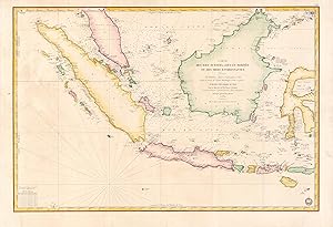
Carte des Iles Sumatra, Java et Borneo et des mers Environnantes.
Publication Date: 1839
Seller: Geographicus Rare Antique Maps, Brooklyn, NY, U.S.A.
Association Member: ABAA ESA ILAB
Seller rating 4 out of 5 stars

Map
� 850.91
Convert currency� 33.19 shipping from U.S.A. to United KingdomQuantity: 1 available
Add to basketVery good. Slight wear. Some creases and spots of discoloration in the margins. Faded annotations in top-left portion of the map. Size 23 x 34.5 Inches. A beautiful and rare 1839 French Depot-General de la Marine nautical chart or maritime map of the East Indies or Insular Southeast Asia - including Singapore. The size and level of detail is impressive, reflecting the importance of the chart as representing the pinnacle of hydrographical knowledge at the time. A Closer Look Based upon the work of the British hydrographer James Horsburgh, namely his groundbreaking work Directions for sailing to and from the East Indies, China, New Holland, Cape of Good Hope, and the interjacent ports , this elegantly hand-colored map covers Sumatra, Java, and Borneo in full, as well as Malay (Malacca) south of Lancava and parts of the Celebes. It further specifically includes the islands of Singapore (Sincapoor), Bali (Bally), Lombok (Lombock), Krakatoa (Crockatoa), and Komodo (Comodo). Soundings, anchorages, shoals, hazards, and supplementary information on currents, longitude, latitude, and more are indicated. Soundings are measures in brasses , a French unit popular at the time roughly similar to a fathom; a table of conversion to meters is provided at bottom-left. Islands, coastal settlements, and other landward features are noted in fantastic detail. Publication History and Census This chart was prepared by Pierre Daussy in 1839 based on the hydrography of James Horsburgh, engraved by Chassant (no given name known), with text by Jacques-Marie Hacq, under the direction of the D� p� t-g� n� ral de la Marine. The map was reissued several times through the 1880s with updates and additions, but the date of 1839 and other identifying information (such as 'No. 889' in the top-right corner) remained, leading to a high degree of variation in cataloging which makes a comprehensive census difficult. This edition, presumably the first as it is the least accurate, differs from more widely available examples in several respects, such as the representation of Singapore and the small islands south of Celebes. Nevertheless, in any edition this chart is quite rare, especially with such exquisite hand-coloring. References: OCLC 888127755, 902603727.