
Order Total (1 Item Items):
Shipping Destination:

Carte Guide Navigation C�ti�re I01 by Vergnot Claude (1 results)
Skip to main search results
Search filters
Product Type
- All Product Types
- Books (No further results match this refinement)
- Magazines & Periodicals (No further results match this refinement)
- Comics (No further results match this refinement)
- Sheet Music (No further results match this refinement)
- Art, Prints & Posters (No further results match this refinement)
- Photographs (No further results match this refinement)
- Maps (1)
- Manuscripts & Paper Collectibles (No further results match this refinement)
Condition Learn more
- New (No further results match this refinement)
- As New, Fine or Near Fine (No further results match this refinement)
- Very Good or Good (1)
- Fair or Poor (No further results match this refinement)
- As Described (No further results match this refinement)
Binding
- All Bindings
- Hardcover (No further results match this refinement)
- Softcover (1)
Collectible Attributes
- First Edition (No further results match this refinement)
- Signed (No further results match this refinement)
- Dust Jacket (No further results match this refinement)
- Seller-Supplied Images (1)
- Not Print on Demand (1)
Language (1)
Price
- Any Price
- Under � 20
- � 20 to � 40 (No further results match this refinement)
- Over � 40 (No further results match this refinement)
Free Shipping
- Free Shipping to U.S.A. (No further results match this refinement)
Seller Location
Seller Rating
-
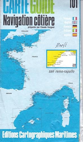
Carte Guide Navigation c�ti�re i01 San Remo-Rapallo
Published by Paris Editions Cartographiques Maritimes, 1978
Language: French
Seller: Versandantiquariat Karin Dykes, N�rnberg, Germany
Seller rating 5 out of 5 stars

Map
lose Bl�tter. Karte ca 63x115 cm. Vor allem das Cover ist etwas knittrig, Namenseintrag. Die Karte selbst hat ein paar leichte Flecken, ist in gutem Zustand, keine L�cher. // Folded map ca 63x115 cm. Cover a bit creased, handwritten name. Map itself has some light stains, but is in good condition, no holes. 1:100.000 50 gr.