
Bristol County by Walling Gray (2 results)

Published by Walling and Grey, 1871
- Map
Seller: Lule A Vavra Rare Maps and Books, Chester, VA, U.S.A.Lule A Vavra Rare Maps and Books
Contact seller4-star sellerCondition: Used - Very good
£ 24.23
Free ShippingShips within U.S.A.Quantity: 1 available
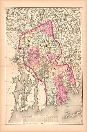
No Binding. Condition: Very Good. ASSACHUSETTS - BRISTOL COUNTY - 1871. ----TITLE: Bristol County. ----BACKGROUND: Bristol County was created by the Plymouth Colony on June 2, 1685, but through the years areas were annexed or carved out to create the configuration shown. The larger towns of Fall River, New Bedford, and Taunton (…the county seat) are shown. Townships are separately colored. Part of Rhode Island is on the left. ----PUBLICATION DETAILS: 22" h x 15"w. Bristol County is in original wash color; the remainder of the map is uncolored. From Walling & Gray, Official Topographical Atlas of Massachusetts (Boston: Stedman, Brown & Lyon, 1871). Walling & Gray also authored atlases of Pennsylvania s in 1871 and Ohio in 1872. ----PUBLISHERS: Henry Francis Walling was a cartographer born in Rhode Island in 1825 and died in Massachusetts in 1888. He was well prepared to publish maps and atlases. He had studied mathematics and surveying. He worked in the office of Barrett Cushing, a civil engineer in Providence. He began topographic work in 1849 preparing atlases containing maps and scientific descriptions of most of the northern states and the Dominion of Canada. He worked with h the geodetic survey of Massachusetts on the preparation of the state maps. He was a fellow of the American association for the advancement of science, and of the American Society of Civil Engineers. ----Ormando Willis Gray was born in Vermont in 1829 and died in Massachusetts in 1912. He was a civil and topographical engineer who produced maps and atlases, both as the publisher and with Walling. In 1869, he lived in Danielsonville, Connecticut. During the 1870s, he was in Philadelphia. Frank A. Gray was evidently O. W. Gray's son. They were partners in the publishing business O.W. Gray & Son in the 1870s and 1880s. ----CONDITION: Short centerfield separations have been mended with archival tape on the verso; otherwise the image is very good. ----N7205.
Seller: Art Source International Inc., Boulder, CO, U.S.A.Art Source International Inc.
Contact seller5-star sellerThis hand colored map is from Walling and Grays Official Topographical Atlas of Massachusetts from Astronomical, Trigonometrical, and Various Local Surveys, published in 1871. This map is of Bristol County colored in vibrant pastels. Details include rail lines, county names, the names of important cities, major roads, lakes and…rivers. This map measures 15 inches by 23 inches.

