
Order Total (1 Item Items):
Shipping Destination:

Brazil by Augustus Mitchell (28 results)
Skip to main search results
Search filters
Product Type
- All Product Types
- Books (27)
- Magazines & Periodicals (No further results match this refinement)
- Comics (No further results match this refinement)
- Sheet Music (No further results match this refinement)
- Art, Prints & Posters (No further results match this refinement)
- Photographs (No further results match this refinement)
- Maps (1)
- Manuscripts & Paper Collectibles (No further results match this refinement)
Condition Learn more
- New (No further results match this refinement)
- As New, Fine or Near Fine (No further results match this refinement)
- Very Good or Good (3)
- Fair or Poor (No further results match this refinement)
- As Described (25)
Binding
- All Bindings
- Hardcover (No further results match this refinement)
- Softcover (No further results match this refinement)
Collectible Attributes
- First Edition (No further results match this refinement)
- Signed (No further results match this refinement)
- Dust Jacket (No further results match this refinement)
- Seller-Supplied Images (24)
- Not Print on Demand (28)
Language (2)
Free Shipping
Seller Location
Seller Rating
-
Map of Brazil, Bolivia, Paraguay, and Uruguay (with) Map of Chili [with inset] Harbor of Bahia [with inset] Harbor of Rio Janeiro [with inset] Island of Juan Fernandez [verso with] Map of Europe, Showing Its Gt. Political Divisions
Language: English
Published by W.M. Bradley, Philadelphia, 1886
Seller: Kaaterskill Books, ABAA/ILAB, East Jewett, NY, U.S.A.
Association Member: ABAA ILAB IOBA
Seller rating 5 out of 5 stars

Hand colored map. Plate 105: Map of Brazil, Bolivia, Paraguay, and Uruguay with two insets of the Harbor of Bahia and the Harbor of Rio de Janeiro [with] Map of Chili, with inset of the Island of Juan Fernandez. Copyright 1886 by Wm. M. Bradley & Bro. 12 x 9.25 inches. [On verso] Plate 106: Map of Europe, Showing Its Gt. Political Divisions. Constructed & Engraved by W. Williams, Philadelphia. Copyright by S. Augustus Mitchell 1884. 13.75 x 11 inches. From: Mitchell's New General Atlas, Containing Maps Of The Various Countries Of The World, Plans Of Cities, Etc., Embraced In Ninety-Three Quarto Maps, Forming A Series Of One Hundred and Forty-seven Maps and Plans, Together With Valuable Statistical Tables. Also, A List Of Post-Offices Of The United States And Territories, And Also Census Of 1880 For States, Territories And Counties, Also Of Cities Of Over 10,000 Inhabitants. Philadelphia: Published By Wm. M. Bradley & Bro., No. 1026 Arch Street. 1886. Very good, faint soiling and browning, few closed edge tears.
-

Map of Brazil, Bolivia, Paraguay and Uruguay.
Published by Philadelphia:, 1861
Seller: Nicholas D. Riccio Rare Books, ABAA, Florham Park, NJ, U.S.A.
Seller rating 4 out of 5 stars

Map of Brazil. South America. (illustrator). Unbound, colored engraved map, decorative border, 14" x 11". Slight toning and aging, a few margin chips and folds; otherwise bright and clear and very good. Maps are wrapped with acid free board, or in rigid sleeves. The Mitchell family started to produce atlases in 1846, and continued into the early 1890s. Around 1860, S. Augustus Mitchell Jr. took over, and the atlas would be called Mitchell's New General Atlas. This is a detailed single page map of Brazil, Chilli and Bolivia from the 1870 installment of this atlas. Uncludes inset showing the harbor of Rio Janeiro. Colorful and attractive. Ristow 311-313.
-
Map of Brazil, Bolivia, Paraguay and Uruguay.
Published by Philadelphia:, 1864
Seller: Nicholas D. Riccio Rare Books, ABAA, Florham Park, NJ, U.S.A.
Seller rating 4 out of 5 stars
Unbound, colored engraved map, decorative border, 14" x 11". Slight toning and aging; otherwise bright and clear and very good. Maps are wrapped with acid free board, or in rigid sleeves. The Mitchell family started to produce atlases in 1846, and continued into the early 1890s. Around 1860, S. Augustus Mitchell Jr. took over, and the atlas would be called Mitchell's New General Atlas. This is a detailed single page map of Brazil, Chilli and Bolivia from the 1864 installment of this atlas. Uncludes inset showing the harbor of Rio Janeiro. Colorful and attractive. Ristow 311-313.
-
Map of Brazil, Bolivia, Paraguay and Uruguay.
Published by Philadelphia:, 1870
Seller: Nicholas D. Riccio Rare Books, ABAA, Florham Park, NJ, U.S.A.
Seller rating 4 out of 5 stars
Unbound, colored engraved map, decorative border, 14" x 11". Slight toning and aging, a few margin chips and folds; otherwise bright and clear and very good. Maps are wrapped with acid free board, or in rigid sleeves. The Mitchell family started to produce atlases in 1846, and continued into the early 1890s. Around 1860, S. Augustus Mitchell Jr. took over, and the atlas would be called Mitchell's New General Atlas. This is a detailed single page map of Brazil, Chilli and Bolivia from the 1870 installment of this atlas. Uncludes inset showing the harbor of Rio Janeiro. Colorful and attractive. Ristow 311-313.
-

Map of Chili - Map of Brazil, Bolivia, Paraguay, and Uruguay
Publication Date: 1868
Seller: Art Source International Inc., Boulder, CO, U.S.A.
Seller rating 5 out of 5 stars
This hand colored map was made for "Mitchells New General Atlas" published by S. Augustus Mitchell, Jr. in 1868. The small map to the left illustrates Chile, while the larger one, on the right, shows Brazil, Bolivia, Paraguay, and Uraguay. The larger map has two insets that show the harbor of Bahia, and the harbor of Rio de Janeiro. Countries are distinguished by color. Other details include the names of states, countries, and important cities, rivers, lakes, mountains, and railroads. The maps in this atlas have beautiful color- more muted than typical. This map measures 13.5 inches by 10.5 inches.
-

Map of Brazil, Bolivia, Paraguay, and Uruguay- Map of Chili
Publication Date: 1864
Seller: Art Source International Inc., Boulder, CO, U.S.A.
Seller rating 5 out of 5 stars
With characteristic floral boarders and beautiful, muted pastel coloring, these 1864 maps are fantastic examples of Mitchells work. Regions, important cities, rivers, lakes, and railroads are identified. The main map on this page illustrates Brazil, Bolivia, Paraguay and Uruguay with insets of the harbors of Bahia and Rio Janeiro. A smaller map shows Chili. This map measures 13.5 inches by 10.75 inches.
-

Mitchell's 1865 Map of Chili, Brazil, Bolivia, Paraguay, and Uruguay
Publication Date: 1865
Seller: Art Source International Inc., Boulder, CO, U.S.A.
Seller rating 5 out of 5 stars
In 1860 S. Augustus Mitchell Jr. took over his father's map publishing business and in that year he started publishing Mitchell's New General Atlas. Editions of the new general were issued annually until 1887. Mitchell Jr. continued publishing this atlas until 1879. The editions from 1880 to 1887 were published by Wm. M. Bradley. This map published in 1865 is a wonderful example of Mitchell's map-making prowess with beautiful original hand-coloring. This map measures 13.5 inches by 10.5 inches.
-

Map of Chili / Map of Brazil, Bolivia, Paraguay and Uruguay
Publication Date: 1867
Seller: Art Source International Inc., Boulder, CO, U.S.A.
Seller rating 5 out of 5 stars
The Mitchell company was one of the first to try out the new technique of engraving on steel plates, experimenting with steel almost 20 years before the rest of the publishing industry. He was printing with steel in the early 1830s; the general switch to steel was approximately 1850. During the early years of the company, Mitchell published mainly maps and travel guides. In 1860, Mitchell started producing "Mitchell's New General Atlas",and Mitchell Sr. retired and turned the business over to his son of the same name. The New General Atlas was published until 1893. Today Mitchell maps are sought after for their fine engraving, bright coloring, and attention to detail. They are some of the finest maps produced in the 1860's. This map produced in 1867, has Mitchell's unique floral border, and beautiful hand coloring. This map details the countries of Chili, Brazil, Bolivia, Paraguay, and Uruguay. Two inset map are included, showing the Harbor of Bahia, and the Harbor of Rio Janeiro. This map measures 13 inches by 10.5 inches.
-

Map of Brazil Bolivia, Paraguay Uruguay Chili
Publication Date: 1872
Seller: Art Source International Inc., Boulder, CO, U.S.A.
Seller rating 5 out of 5 stars
This map was made by S. Augustus Mitchell in 1872. Featured with Mitchells characteristic pastel coloring and abundant details of geographical features. Chili, Brazil, Bolivia, Paraguay and Uruguay are illustrated on this map. Inset maps of the Harbor of Bahia and the Harbor of Rio Janeiro are included as well. Details include the names of regions, important towns, rivers, lakes, mountain ranges and railroads. Counties are distinguished by color. These 1872 maps offer a fascinating perspective of areas that have since undergone significant growth and change, in addition to their value as great examples of Mitchell's work. This map measures 13.5 inches by 10.5 inches.
-

Map of Brazil, Bolivia, Paraguay, and Uruguay
Publication Date: 1884
Seller: Art Source International Inc., Boulder, CO, U.S.A.
Seller rating 5 out of 5 stars
This map was made by S. Augustus Mitchell for "Mitchells New General Atlas" published in 1884, by WM. M. Bradley & Co. The well maintained maps in this atlas feature Mitchell's characteristic pastel coloring and abundant geographical features. Details include the names of countries, regions, cities, towns, transportation routes, rivers, lakes, and mountain ranges. Regions are distinguished by color. These 1884 maps offer a fascinating perspective of areas that have since undergone significant growth and change, in addition to their value as great examples of Mitchell's work. This map measures 13.5 inches by 11 inches.
-

Map of Brazil, Bolivia, Paraguay, and Uruguay, and Chile
Publication Date: 1885
Seller: Art Source International Inc., Boulder, CO, U.S.A.
Seller rating 5 out of 5 stars
This map was made by S. Augustus Mitchell for "Mitchells New General Atlas" published in 1885, by WM. M. Bradley & Co. The well maintained maps in this atlas feature Mitchell's characteristic pastel coloring and abundant details of geographical features. Brazil, Bolivia, Paraguay, and Uruguay are illustrated, with inset maps of the Island of Juan Fernandez, the Harbor of Bahia and the Harbor of Rio Janeiro. Details include the names of countries, regions, cities, towns, transportation routes, rivers, lakes, and mountain ranges. Regions are distinguished by color. These 1885 maps offer a fascinating perspective of areas that have since undergone significant growth and change, in addition to their value as great examples of Mitchell's work. This map measures 12 inches by 9 inches.
-

Map of Chile, Map of Brazil, Bolivia, Paraguay, and Uruguay with inset maps of Harbor of Bahia and Harbor of Rio Janero
Publication Date: 1866
Seller: Art Source International Inc., Boulder, CO, U.S.A.
Seller rating 5 out of 5 stars
The Mitchell company was one of the first to try out the new technique of engraving on steel plates experimenting with steel almost 20 years before the rest of the publishing industry. He was printing with steel in the early 1830s; the general switch to steel was approximately 1850. During the early years of the company, Mitchell published mainly maps and travel guides. In 1860, Mitchell started producing "Mitchell's New General Atlas",and Mitchell Sr. retired and turned the business over to his sonof the same name. The New General Atlas was published until1893. Today Mitchell maps are sought after for their fine engraving, bright coloring, and attention to detail. They aresome of the finest maps produced during this time period. This map produced in 1866, has Mitchell's unique floral border, and beautiful hand coloring. This map details Chile, Brazil, Bolivia, Paraguay, and Uruguay with inset maps of Harbor of Bahia and Harbor of Rio Janero. Countries, cities, towns, lakes, rivers, mountains, and transportation routes are noted. Each map was printed on thick paper with vibrant hand color. This map measures 13.25 inches by 10.5 inches.
-

Map of Brazil, Bolivia, Paraguay, and Uruguay, with Insets of Chili, Bahia, Juan Fernandez, and Rio di Janiero
Publication Date: 1875
Seller: Art Source International Inc., Boulder, CO, U.S.A.
Seller rating 5 out of 5 stars
This map was produced by S. Augustus Mitchell in 1875 for his New General Atlas. This map shows Mitchells traditional grape vine border, characteristic pastel coloring and abundant details of geographical features. Counties are distinguished by different colors. Wagon trails and major routes of transport are also shown. These 1875 maps offer a fascinating perspective of areas that have since undergone significant growth and change, in addition to their value as great examples of Mitchell's work. This map measures 13.5 inches by 10.5 inches.
-

Map of Chili; Map of Brazil, Bolivia, Paraguay, and Uruguay; Island of Juan Fernandez; Harbor of Bahia; Harbor of Rio Janeiro
Publication Date: 1878
Seller: Art Source International Inc., Boulder, CO, U.S.A.
Seller rating 5 out of 5 stars
This map of Chili, Brazil, Bolivia, Bolivia, Paraguay, and Uruguay was produced by Augustus Mitchell in 1878 for his New General Atlas. Highlights of this map are Mitchells traditional grapevine border, characteristic pastel coloring and abundant details of geographical features. This 1878 map offers a fascinating perspective of areas that have since undergone significant growth and change, in addition to the value as great examples of Mitchell's classic mapmaking style. This map measures 1 inches by 1 inches.
-

Map of Brazil, Bolivia, Paraguay, Uruguay and Chili
Publication Date: 1874
Seller: Art Source International Inc., Boulder, CO, U.S.A.
Seller rating 5 out of 5 stars
This map was produced by S. Augustus Mitchell in 1874 for his New General Atlas. This map shows Mitchell's traditional grape vine border, characteristic pastel coloring and abundant details of geographical features. Maps of Brazil, Bolivia, Paraguay, Uruguay and Chili are illustrated on this map, as well as two small inset maps of the Harbor of Bahia and the Bay of Rio Janeiro. Countries are distinguished by color. These 1874 maps offer a fascinating perspective of areas that have since undergone significant growth and change, in addition to their value as great examples of Mitchell's work This map measures 14 inches by 11 inches.
-

Map of Brazil, Bolivia, Paraguay, and Uruguay. Map of Chili
Publication Date: 1860
Seller: Art Source International Inc., Boulder, CO, U.S.A.
Seller rating 5 out of 5 stars
This beautiful map of Brazil, Bolivia, Paraguay, Uruguay, and Chili was made by S. Augustus Mitchell, in 1860, for his New General Atlas. This map features bright original hand coloring that differentiates regions and country sections, a decorative floral border, and fine detailing. This map also includes three insets of the Island of Juan Fernandez, the Harbor of Bahia, and the Harbor of Rio Janeiro. This map measures 13.25 inches by 10.5 inches.
-

Map of Chili; Map of Brazil, Bolivia, Paraguay, and Uruguay; Island of Juan Fernandez; Harbor of Bahia; Harbor of Rio Janeiro
Publication Date: 1879
Seller: Art Source International Inc., Boulder, CO, U.S.A.
Seller rating 5 out of 5 stars
This map of Chili, Brazil, Bolivia, Paraguay, and Uruguay was produced by Augustus Mitchell in 1879 for his New General Atlas. Highlights of this map are Mitchells traditional grapevine border, characteristic pastel coloring and abundant details of geographical features. This 1879 map offers a fascinating perspective of areas that have since undergone significant growth and change, in addition to the value as great examples of Mitchell's classic map-making style. This map measures 13.5 inches by 11 inches.
-
Map of Chili, Map of Brazil, Bolivia, and Uruguay
Published by S. Augustus Mitchell, Philadelphia, 1860
No Binding. Condition: Good.
-

Map of Chili (with inset map of Island of Juan Fernandez). Map of Brazil, Bolivia, Paraguay, and Uruguay (with inset maps of Bahia Harbor and Rio Janeiro Harbor).
Publication Date: 1888
Seller: Art Source International Inc., Boulder, CO, U.S.A.
Seller rating 5 out of 5 stars
This map of Chili, Brazil, Bolivia, Paraguay, and Uruguay (with inset maps of Island of Juan Fernandez, Bahia Harbor and Rio Janeiro Harbor) was made by S. Augustus Mitchell for "Mitchells New General Atlas" published in 1888, by WM. M. Bradley & Co. The well maintained maps in this atlas feature Mitchell's characteristic pastel coloring and abundant details of geographical features. Details include the names of countries, cities, towns, transportation routes, mountain ranges, harbors, islands, rivers and lakes. These 1888 maps offer a fascinating perspective of areas that have since undergone significant growth and change, in addition to their value as great examples of Mitchell's work. This map measures 13.5 inches by 10.5 inches.
-

Map of Brazil, Bolivia, Paraguay, and Uruguay - Map of Chili
Publication Date: 1877
Seller: Art Source International Inc., Boulder, CO, U.S.A.
Seller rating 5 out of 5 stars
This hand colored map was made by S. Augustus Mitchell for "Mitchells New General Atlas" in 1877. The map on the left illustrates Chili with an inset of the Island of Juan Fernandez. The right map shows Brazil, Bolivia, Paraguay, and Uruguay with insets of Rio de Janero and Bahia. Details include the names of countries and important cities, and illustrations of mountains, lakes, rivers, and major roads. This map measures 13.5 inches by 10.5 inches.
-

Brazil, Bolivia, Paraguay and Uruguay, Chili
Publication Date: 1861
Seller: Art Source International Inc., Boulder, CO, U.S.A.
Seller rating 5 out of 5 stars
This exceptional map is from "Mitchells New General Atlas" published by S. Augustus Mitchell, Jr in 1861. This steel plate engraved map has original hand coloring and crisp engraved lines. Maps from this 1861 ( 2nd edition) atlas have become very difficult to acquire.Surrounding these maps of Brazil, Bolivia, Paraguay and Uruguay, Chili is a ' inch floral border. Counties, provinces, many cities,rivers and lakes are identified on this beautiful map. Inset maps showing Island of Juan Fernandez, the Harbor of Bahia and the Harbor of Rio de Janeiro are included. This map measures 13.25 inches by 10.5 inches.
-

Map of Chili - Map of Brazil Bolivia Paraguay and Uraguay
Publication Date: 1870
Seller: Art Source International Inc., Boulder, CO, U.S.A.
Seller rating 5 out of 5 stars
S. Augustus Mitchell Jr. made this hand colored map for "Mitchells New General Atlas" in 1870. Brazil, Bolivia, Paraguay, and Uraguay are illustrated on the main map with insets of Rio Janeiro and the Harbor of Bahia. The smaller map shows Chili and an inset of the Island of Juan Fernandez. Regions are distinguished by bright pastel colors. Lakes, mountains, rivers, important cities and countries are identified. This map measures 13.25 inches by 10.5 inches.
-

Brazil
Published by Philadelphia, 1846
Seller: Antiquariat Reinhold Berg eK Inh. R.Berg, Regensburg, Germany
Seller rating 5 out of 5 stars
Map
Other. Lithograph, period hand color in wash and outline when published. Original hand color in outline and wash when published. 377 by 312mm (14� by 12� inches).
-

Map of Chili, Map of Brazil, Bolivia, and Uruguay
Publication Date: 1881
Seller: Art Source International Inc., Boulder, CO, U.S.A.
Seller rating 5 out of 5 stars
This map came from Mitchells New General Atlas, 1881.This map shows major railroads, water bodies, and towns.Decorative ivy border, and nice colorful detail. Would looknice framed!' This map measures 13.5 inches by 11 inches.
-
1866 Color Steel Engraved Map of BRAZIL Bolivia Paraguay CHILI South America
Published by Philadelphia : S. Augustus Mitchell, 1866., 1866
No Binding. Condition: Very Good. 1866 Color Steel Engraved Map of BRAZIL Bolivia Paraguay CHILI South America Samuel Augustus Mitchell (1790 1868) was an American geographer. Map maker: Samuel Augustus Mitchell Title: "Map of Brazil, Bolivia, Paraguay, and Uruguay. Map of Chili." Atlas Title: Mitchell's New General Atlas containing maps of the various countries of the world, plans of cities, etc., embraced in fifty-eight quarto maps, forming a series of ninety-two maps and plans, together with valuable statistical tables. Published: Philadelphia : S. Augustus Mitchell, 1866. FREE SHIPPING WORLDWIDE Wear: wear as seen in photos Publisher: Philadelphia : S. Augustus Mitchell, 1866. Size: ~17.5in X 14in (44.5cm x 35.5cm) Photos available upon request.
-
1866 Color Steel Engraved Map of SOUTH AMERICA Brazil Patagonia PERU Bolivia
Published by Philadelphia : S. Augustus Mitchell, 1866., 1866
No Binding. Condition: Very Good. 1866 Color Steel Engraved Map of SOUTH AMERICA Brazil Patagonia PERU Bolivia Samuel Augustus Mitchell (1790 1868) was an American geographer. Map maker: Samuel Augustus Mitchell Title: "Map of South America, showing it's political divisions." Atlas Title: Mitchell's New General Atlas containing maps of the various countries of the world, plans of cities, etc., embraced in fifty-eight quarto maps, forming a series of ninety-two maps and plans, together with valuable statistical tables. Published: Philadelphia : S. Augustus Mitchell, 1866. FREE SHIPPING WORLDWIDE Wear: wear as seen in photos Publisher: Philadelphia : S. Augustus Mitchell, 1866. Size: ~17.5in X 14in (44.5cm x 35.5cm) Photos available upon request.
-
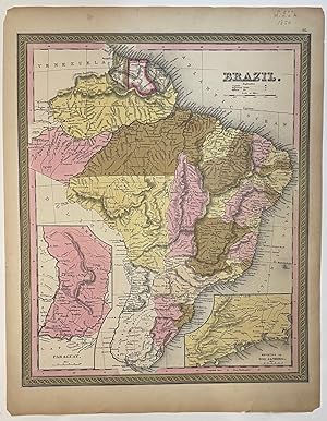
Brazil
Published by Thomas, Cowperthwait & Co, Philadelphia, 1850
Seller: Argosy Book Store, ABAA, ILAB, New York, NY, U.S.A.
Seller rating 5 out of 5 stars
unbound. Map. Lithograph with original hand coloring. Image measures 11 7/8" x 14 7/8". A beautiful map of Brazil, from 1850 including Uruguay, Paraguay, and Guiana. Hand colored to show provinces, and relief is shown by hachure. Rivers and cities are labeled. Features two insets, one of Paraguay, and the other showing Environs of Rio Janiero. Both insets also show major roads. Overall, this is an excellent copy of this map, with slight toning to margins, not affecting the image. Published in the 1850 Cowperthwait edition of Mitchell's seminal "New Universal Atlas". Samuel Augustus Mitchell Sr. (1792-1868) is one of the leaders in American cartography of the 19th century and pioneered the conversion of engraved map plates to more affordable lithographic plates. His son, Samuel Augustus Mitchell Jr. continued his father's successful mapmaking and publishing business, and was one of the most prolific and renowned 19th century American publishers.
-

Brazil
Publication Date: 1851
Seller: Art Source International Inc., Boulder, CO, U.S.A.
Seller rating 5 out of 5 stars
A wonderful map from S. Augustus Mitchells "A New Universal Atlas Containing Maps of the Various Empires, Kingdoms, States, and Republics of the World". Mitchell was the most successful commercial cartographer in the US. He sold his business to the Milton Bradley Company in the 1880's. His maps from the 1850's have become extremely difficult to obtain, especially in this fine condition. This map measures 12.75 inches by 15 inches.
![Seller image for Map of Brazil, Bolivia, Paraguay, and Uruguay (with) Map of Chili [with inset] Harbor of Bahia [with inset] Harbor of Rio Janeiro [with inset] Island of Juan Fernandez [verso with] Map of Europe, Showing Its Gt. Political Divisions for sale by Kaaterskill Books, ABAA/ILAB](https://pictures.abebooks.com/inventory/md/md30661485704.jpg)


