Order Total (1 Item Items):
Shipping Destination:

Beaverhead Recreation Area (1 results)
Skip to main search results
Search filters
Product Type
- All Product Types
- Books (No further results match this refinement)
- Magazines & Periodicals (No further results match this refinement)
- Comics (No further results match this refinement)
- Sheet Music (No further results match this refinement)
- Art, Prints & Posters (No further results match this refinement)
- Photographs (No further results match this refinement)
- Maps (1)
- Manuscripts & Paper Collectibles (No further results match this refinement)
Condition Learn more
- New (No further results match this refinement)
- As New, Fine or Near Fine (No further results match this refinement)
- Very Good or Good (No further results match this refinement)
- Fair or Poor (No further results match this refinement)
- As Described (1)
Binding
- All Bindings
- Hardcover (No further results match this refinement)
- Softcover (No further results match this refinement)
Collectible Attributes
- First Edition (No further results match this refinement)
- Signed (No further results match this refinement)
- Dust Jacket (No further results match this refinement)
- Seller-Supplied Images (1)
- Not Print on Demand (1)
Language (1)
Price
- Any Price
- Under � 20 (No further results match this refinement)
- � 20 to � 40 (No further results match this refinement)
- Over � 40
Free Shipping
- Free Shipping to U.S.A. (No further results match this refinement)
Seller Location
Seller Rating
-
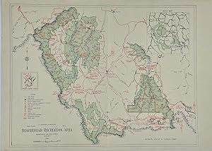
Beaverhead Recreation Area
Published by U.S. Department of Agriculture, Forest Service, Beaverhead National Forest, MT, 1942
Seller: Tschanz Rare Books, Salt Lake City, UT, U.S.A.
Association Member: ABAA ILAB RMABA
Seller rating 3 out of 5 stars

Map
Map [23 cm x 31 cm] on a single sheet [25.5 cm x 35 cm] printed in black, red, and green ink. Vertical fold at center - two horizontal folds. About very good. Inset map [7 cm x 7 cm] at the upper right corner showing the greater area. Nice map of this area of southern Montana and western Idaho with Dillon, Montana at the center. Map locates the area that encompasses the national forests; towns; main roads; mines; airstrips/landing fields; fire lookouts; ranger stations; trails; resorts; camp sites; and game preserves. Small printed notice at the left: "Don't be a Flipper - Prevent Forest Fires.".