Order Total (1 Item Items):
Shipping Destination:

A Map of the County of Stafford (15 results)
Feedback
Skip to main search results
Search filters
Product Type
- All Product Types
- Books (9)
- Magazines & Periodicals (No further results match this refinement)
- Comics (No further results match this refinement)
- Sheet Music (No further results match this refinement)
- Art, Prints & Posters (No further results match this refinement)
- Photographs (No further results match this refinement)
- Maps (6)
- Manuscripts & Paper Collectibles (No further results match this refinement)
Condition
Binding
Collectible Attributes
- First Edition (2)
- Signed (No further results match this refinement)
- Dust Jacket (No further results match this refinement)
- Seller-Supplied Images (8)
- Not Print on Demand (15)
Language (2)
Free Shipping
Seller Location
Seller Rating
-

PAP. Condition: New. New Book. Shipped from UK. Established seller since 2000.
-

HRD. Condition: New. New Book. Shipped from UK. Established seller since 2000.
-

� 36
Convert currency� 20 shipping from United Kingdom to U.S.A.Quantity: 1 available
Add to basketSoft cover. Condition: Fine. 6 folded maps and staple bound book contained in burgundy cloth covered slipcase.
-
STAFFORDSHIRE A New Map of the County of STAFFORD Divided into Hundreds. Printed for C. Smith No. 172 Strand January 6th 1804, 2nd Edition Corrected to 1808
Published by Charles Smith, London, 1808
Language: English
Seller: Andrew Cox PBFA, Shropshire, United Kingdom
Association Member: PBFA
Seller rating 5 out of 5 stars

Map
� 75
Convert currency� 27 shipping from United Kingdom to U.S.A.Quantity: 1 available
Add to basketNo Binding. Condition: Good. Published in 1808, this is the second edition of this map of Staffordshire by Charles Smith, mounted on linen in twelve panels, the map measures 53cm by 47cm approx., the map is generally browned, one split along a fold line, some edge wear marks and a few small pinholes to the corners else in good general condition. this is a lighter item, shipping costs will be reduced at checkout where possible.
-

A Topographical Survey of the Counties of Stafford, Chester & Lancaster. containing a new engraved map of each county .
Published by E. Snelson (Nantwich), GB, 1787
Seller: Richard Sylvanus Williams (Est 1976), WINTERTON, United Kingdom
Seller rating 5 out of 5 stars
First Edition
� 184.26
Convert currency� 13 shipping from United Kingdom to U.S.A.Quantity: 1 available
Add to basketHardback. Condition: Good. Dust Jacket Condition: No DW. 1st Edition. Maps enetite but some wear. Original text has some spotting, browning and minor signs of old damp. Now fitted with new endpapers and rebound in plain pale brown paper covered boards with plain dark brown cloth spine. A good working copy. The final leaf is a request by the author for "the place of Steward to a Nobleman or Gentleman".
-
A Map of the Parish of Kingswinford in the County of Stafford, from a Survey made in the year 1822
Published by Fowler, 1822
� 242.50
Convert currency� 24.60 shipping from United Kingdom to U.S.A.Quantity: 1 available
Add to basketCondition: Good. This is an ex-library map and may have the usual library markings. Linen back, size approx. 48 inches x 37 inches. 'Scale of 80 Chains of 1 Mile'. Generally a bit grubby and browned, but physically in good condition apart from slight wear to outer edges. There is a detailed 'Explanation' in the bottom right hand corner, and remnants of green cord ties on the bottom edge. Two tears at the top of the map approx 5 inches, in blank area around detail of map. This map will be sent rolled up in a crush proof tube. Please note the Image in this listing is a stock photo and may not match the covers of the actual item,450grams, ISBN:
-
A Topographical Survey of the Counties of Stafford, Chester, and Lancaster, Containing a new-engraved map of each County, with a complete Description of the Great, Direct, and Cross Roads.
Published by Nantwich: Printed and Sold by E. Snelson., 1787
Seller: Forest Books, ABA-ILAB, Grantham, LINCS, United Kingdom
Association Member: ABA ILAB PBFA
Seller rating 5 out of 5 stars
Map First Edition
� 345
Convert currency� 12.50 shipping from United Kingdom to U.S.A.Quantity: 1 available
Add to basketFirst edition, 8vo (212 x 130 mm), iv, 118pp., 3 folding engraved plates, 32 plates of heraldic crests printed back-to-back, some offsetting and light spotting, contemporary calf, upper cover with Order of the Garter arms stamped in gilt, neatly rebacked, a nice copy. Provenance: Eric Sexton, F.S.A. (Lord Sexton, 1902-1980), his bookplate.
-
A Topographical Survey of the Counties of Somerset, Gloucester, Worcester, Stafford, Chester, and Lancaster. Containing A new-engraved Map of each County, with a complete Description of the Great, Direct, and Cross Roads .
Published by Printed and sold by R. Cruttwell ., Bath, 1789
Seller: Clive A. Burden Ltd., Chalfont St. Giles, BUCKS, United Kingdom
Seller rating 3 out of 5 stars

Map
� 450
Convert currency� 22.15 shipping from United Kingdom to U.S.A.Quantity: 1 available
Add to basketNo binding. Octavo (220 x 135 mm.), contemporary half calf, marbled paper boards, blind ruled, rebacked preserving original spine with gilt and blind ruled bands, each compartment with central gilt feature, gilt title. With typographic half title and full title, six parts bound in two sections, pp. (vi), (2), 34, (2), 35-64, (2), 67-88; (2), 40; (2), 41-68, (2) , 69-118, with 6 folding maps and each with 8 plates of the Arms of the Nobility for each county, Lancashire has 16, Somerset with some fold repair an minor loss, Staffordshire with light browning at a fold, otherwise in good condition. William Tunnicliff (fl.1784-96) was a land surveyor and cartographer. In 1786 he began publishing a series of 'Topographical Surveys' of individual counties. In that year he was also advertising for employment and it seems that the series was a stop gap to further employment. Those of Staffordshire, Cheshire and Lancashire were all issued with maps dated 1786 and bearing 'Price 7 Shills.' in the title. These three were then brought together under one title in 1787. Clearly successful he decided to expand the work with three further neighbouring counties, namely Worcestershire, Gloucestershire, and Somerset. The map for Worcestershire is dated 1788. The six appeared as 'A Topographical Survey of the Counties of �' in 1789, offered here. The two groups of three counties have their own contiguous pagination. The first three counties issued; each contain slightly smaller folding maps. The work was effectively a cross between a road book and commercial directory. Each county contains a description of all the main roads with an index, a list of subscribers, followed by a fascinating directory of the 'Principal Merchants and Manufacturers' for each town. Each town also identifies market days, fairs and principal inns. The work was supported by subscription and encouraged by the plates of coat of arms. Numerous blank ones remain, possibly to encourage further contributions. A large amount of industrial information is included, such as a focus on canals, a feature which was dramatically changing the landscape at the time. This was a time that the industrial revolution was rapidly changing the country.The Lancashire map records the Manchester to Mersey canal and even the intended Liverpool to Leeds Canal. That of Staffordshire records the Soho Manufacturing plant north west of Birmingham. It was an early factory to work on the principal of mass production on an assembly line principal. Founded in 1766 by Matthew Boulton it was the first to use a Watt steam engine in 1782. It would also be home to the first steam powered mint. The three ensuing counties, here bound first, are each accompanied with a much larger folding map. Certainly, larger than might be expected for a work this size. The resultant scale is likewise improved. The Cheshire here is first state and Staffordshire is second state. Fordham (1924) p. 39; King (1988) no. 45 st. 2; Needell (1995) no. 106; not in Saunders (2013); Smith (1989a); Whittaker (1942) nos. 260 & 266.
-

A NEW MAP OF THE COUNTY OF STAFFORD FROM SMITH'S NEW ENGLISH ATLAS
Published by C. Smith, LONDON, UK, 1804
� 74.95
Convert currency� 25 shipping from United Kingdom to U.S.A.Quantity: 1 available
Add to basketNo Binding. Condition: Very Good. 1st edition thus. Original engraving with original hand-colouring. Date: 1801. SHEET SIZE: c.63.2cm x 46.7cm. Description: Ready for framing. VERY MINOR AGE STAINING. SMALL CHIP TO THE LEFT HAND MARGIN. VERY MINOR REPAIRED TEAR TO THE UPPER MARGIN, WELL AWAY FROM THE PLATE SURFACE. ORIGINAL HAND-COLOURING BRIGHT AND CLEAN. IN VERY GOOD CONDITION INDEED. Location: MAP DRAWER B: FS: FOLDER 1002.
-

A NEW MAP of the COUNTY of STAFFORD Divided into Hundreds.
Published by Smith's English Atlas Being a Complete Set of County Maps, Divided into Hundreds. London. Printed for C. Smith 1804, 1804
Seller: Peter Harrington. ABA/ ILAB., London, United Kingdom
Association Member: ABA ILAB PBFA
Seller rating 5 out of 5 stars
� 120
Convert currency� 14 shipping from United Kingdom to U.S.A.Quantity: 1 available
Add to basketVery handsome and detailed county map shows market towns with distances from London in measured miles. The major canals, roads, railways, parks, churches and chapels are also clearly marked. A fine map with a decorative compass rose. Copper engraving. Very good condition. Original colour. Size: 49 x 54.5 cm.
-
A Topographical Survey of The Counties of Somerset, Gloucester, Worcester, Stafford, Chester, and Lancaster. Containing A New-engraved Map of each County &c.
Published by Bath: Printed and sold by R. Cruttwell &c,, 1789
Seller: Colin Page Books, Storrington, United Kingdom
Association Member: ABA ILAB PBFA
Seller rating 5 out of 5 stars
� 450
Convert currency� 40 shipping from United Kingdom to U.S.A.Quantity: 1 available
Add to basketFirst edition. Octavo (22.5 x 14cm). pp. vi,[2],34,[2],35-88,[2],40[2],41-68,[2],69-,[2]. Each of the six counties having a large folding map plus eight engraved plates & armorials printed on four sheets, the Lancashire armorials mis-numbered. The final advertisement leaf curiously is a request from Tunnicliff for employment as a land steward to a Nobleman or Gentleman and requesting correspondence to be directed to the Post-Office at Manchester. Original boards, with some light soiling, the corners a little worn, with new spine & label, the contents with some occasional light browning, the six folding maps quite sound. 19th C Leeds bookseller's label to fixed front endpaper. Vg. [Shirley I, 1004; Hyett & Bazeley I, 131; Austin 283; Simms 467; Chubb, Maps of Somersetshire 64; Eden II, T282; Norton 7].
-
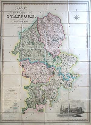
A Map of the County of Stafford Divided into Hundreds & Parishes, From an Accurate Survey, Made in the Years 1831 & 1832
Published by London: Henry Teesdale August 1st, 1832., 1832
Seller: Bow Windows Bookshop (ABA, ILAB), Lewes, United Kingdom
Association Member: ABA ILAB PBFA
Seller rating 5 out of 5 stars
Map
� 675
Convert currency� 27 shipping from United Kingdom to U.S.A.Quantity: 1 available
Add to basketMap dimensions 132 x 97.5 cm, overall 137 x 100 cm. Large folding map of the county with original wash colour in block and outline, vignette illustration of Lichfield Cathedral to the lower right corner and an explanatory key to the lower left, dissected into 36 sections and mounted on linen, all edges trimmed with green silk, marbled paper panels to the folded end sections, housed within a contemporary book style two part box of tan full calf, gilt to the spine. The case worn but sound, wanting the spine label and with surface losses, the map very good.
-

A Map of the County of Stafford Divided into Hundreds & Parishes, From an Accurate Survey, Made in the Years 1831 & 1832, By J. Phillips & W. J. Hutchings, London.
Published by Published by Henry Teesdale & Co. 302, High Holborn, August 1st, 1832., London,, 1832
Seller: Daniel Crouch Rare Books Ltd, London, United Kingdom
Association Member: ABA ILAB PBFA
Seller rating 4 out of 5 stars

Map
� 1,000
Convert currency� 20 shipping from United Kingdom to U.S.A.Quantity: 1 available
Add to basketStaffordshire - Hutchings' large-scale map of Staffordshire Large engraved map, dissected and mounted on linen, fine original full-wash colour, south east view of Lichfield cathedral, edged in green silk. Uncommon. A fine example in full original wash colour. There is a view of Lichfield Cathedral at the lower right. A table of explanation towards the bottom left outlines a wealth of topographical detail, including ichnographic representations of the principal towns, villages, churches, gentleman's seats, commons, heaths and hills, parish and other boundaries, canals, wind and water-mills, roads, lanes, toll-bars and rivers.