
Order Total (1 Item Items):
Shipping Destination:

A Chart of the World on Mercator's Projection: Maps (15 results)
Feedback
Skip to main search results
Search filters
Product Type
- All Product Types
- Books (2)
- Magazines & Periodicals (No further results match this refinement)
- Comics (No further results match this refinement)
- Sheet Music (No further results match this refinement)
- Art, Prints & Posters (No further results match this refinement)
- Photographs (No further results match this refinement)
- Maps (15)
- Manuscripts & Paper Collectibles (No further results match this refinement)
Condition
- All Conditions
- New (No further results match this refinement)
- Used (15)
Binding
Collectible Attributes
- First Edition (No further results match this refinement)
- Signed (1)
- Dust Jacket (No further results match this refinement)
- Seller-Supplied Images (14)
- Not Print on Demand (15)
Language (1)
Price
- Any Price
- Under � 20 (No further results match this refinement)
- � 20 to � 40 (No further results match this refinement)
- Over � 40
Free Shipping
Seller Location
Seller Rating
-

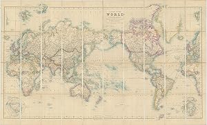
A Chart of the World on Mercator's Projection Shewing the principal Ocean Steam Routes, the Submarine Telegraphs &c.
Published by LondonEdward Stanford 55 Charing Cross Jan. 1st ., 1885
Seller: Robert Frew Ltd. ABA ILAB, London, United Kingdom
Association Member: ABA ILAB PBFA
Seller rating 4 out of 5 stars

Map
� 950
Convert currency� 10 shipping from United Kingdom to U.S.A.Quantity: 1 available
Add to basketOriginal engraved map of the world (69.5 x 103.5 cm) with outline colour, dissected into 40 panels and laid onto linen, two panels with marbled endpapers, folding into original brown cloth slipcase with publisher's yellow title label to upper portion. The map recording steam routes including travel times and underwater telegraph cables; map inserts of the Arctic and Antarctica (polar projection) in lower right and lower left quadrants. Generally an excellent, well preserved copy. Edward Stanford, Fellow of the Royal Geographical Society, acquired the plates and stock of John Arrowsmith in 1874.
-
A Chart of the World on Mercator's Projection Shewing the principal Ocean Steam Routes, the Submarine Telegraphs &c.
Published by LondonEdward Stanford 55 Charing Cross June 1st ., 1881
Seller: Robert Frew Ltd. ABA ILAB, London, United Kingdom
Association Member: ABA ILAB PBFA
Seller rating 4 out of 5 stars
Map
� 1,250
Convert currency� 10 shipping from United Kingdom to U.S.A.Quantity: 1 available
Add to basketOriginal engraved map of the world (69.5 x 103.5 cm) with outline colour, dissected into 40 panels and laid onto linen, two panels with marbled endpapers, folding into original brown cloth slipcase with publisher's yellow title label to upper portion. The map recording steam routes including travel times and underwater telegraph cables; map inserts of the Arctic and Antarctica (polar projection) in lower right and lower left quadrants. Some occasional light soiling, generally an excellent example. Edward Stanford, Fellow of the Royal Geographical Society, acquired the plates and stock of John Arrowsmith in 1874.
-

A Chart of the World on Mercator's Projection Shewing the Principal Ocean Steam Routes, the Submarine Telegraph &c
Published by Edward Stanford, London, 1881
Map
No binding. Condition: Very good. London: Edward Stanford, 1881. Engraved case map of the world in 40 segments (26 � x 44 � inches) mounted to original linen backing with promotional self-wrappers ("Stanford's Two-Shilling Series of Tourists Guides / New Maps and New Editions"), recording steam routes including travel times and underwater telegraph cables; map inserts of the Arctic and Antarctica (polar projection) in lower right and lower left quadrants. Condition: very good with original color in outline; small creasing in lower right corner and some isolated foxing. Edward Stanford, Fellow of the Royal Geographical Society, acquired the plates and stock of John Arrowsmith in 1874. Note some scattered annotations regarding the achievements of 19th century naval officers and explorers that Stanford added to the present map, including the mention of William Parry's (1790-1855) attempt on the North Pole from the northern shores of Spitsbergen in 1827 (recorded beyond the neatline of the present map).
-
A New Chart of the World on Mercator's Projection, with the Tracks of the Most Celebrate & Recent Navigators.
Published by London: H. Teesdale, 1842., 1842
Seller: Arader Galleries - AraderNYC, New York, NY, U.S.A.
Seller rating 5 out of 5 stars

Map Signed
Full Leather. Condition: Very Good. 1 map (129 x 194 cm.): hand-colored, engraved by John Dower, divided into sections on 2 sheets and laid on linen; 5-line ink note in lower left corner, housed in original publisher's maroon morocco portfolio (38.5 x 26.5 cm.), with title "Teesdale's Map of the World" stamped in gilt on front board. A FINE LARGE WALL MAP SHOWING THE TRACKS OF THE MAJOR EXPLORERS TO THE MID-1830S, WITH OTHER INTERESTING AND IMPORTANT EVENTS NOTED. British recognition of the Republic of Texas in November of 1840 is recorded, although James Hamilton was only able to agree three treaties with the British at this stage. These were related to commerce and navigation, a second provided for British mediation in the Texas-Mexico difficulties concerning peace, and a third called for the suppression of slave trade, and though signed in November 1840, because of various delays ratifications were not actually exchanged until July 28, 1842. The new boundary between the British Possessions in North America and the United States which was only decided as recently as April of 1842 with the signing of the Webster-Ashburton Treaty is recorded. This treaty settled many long-standing issues between the United States and England that by 1842 had become acute. These included U.S.-Canadian boundary disputes; the 1837 burning by Canadians of a U.S. steamship, the Caroline, in the Niagara River, with the death of a crewman; the 1840 arrest in New York State of a Canadian, Alexander McLeod, accused of involvement in the Caroline affair; and the refusal of British authorities to return to the United States the African-American slaves who in 1841 had seized and diverted to the Bahamas a U.S. brig, the Creole, transporting them from Virginia to New Orleans. The Webster-Ashburton Treaty granted the United States nearly 60 percent of the disputed area in the Northeast, including a strategic military location at the top of Lake Champlain, along with a region west of Lake Superior, Minnesota's Mesabi Range, that later proved rich in iron ore. It also allowed Americans to turn westward and encouraged what proved to be an enduring Anglo-American rapprochement. Map.
-

A Chart of the World on Mercator's Projection (ca 1815)
Publication Date: 1815
Seller: Waimakariri Books and Prints Limited, Oxford, New Zealand
Seller rating 4 out of 5 stars
Map
� 56.84
Convert currencyFree shipping from New Zealand to U.S.A.Quantity: 1 available
Add to basketNo Binding. Condition: Very Good. Page size 29 x 23 cm approx, single fold (as published). Light age wear and marks with slight edge tanning. Very Good. Free standard airmail worldwide. Tracking available at additional cost.
-
'A CHART OF THE WORLD ON MERCATOR'S PROJECTION SHEWING THE PRINCIPAL OCEAN STEAM ROUTES, THE SUBMARINE TELEGRAPHS &C.'. Map of the British Empire, printed on two sheets, with circular insets of North and South Pole.
Published by Edward Stanford, London ca. 1900, 1900
Map
� 125
Convert currency� 35 shipping from United Kingdom to U.S.A.Quantity: 1 available
Add to basketCondition: Fine. 61x107cm when joined. Printed in full colours. Excellent condition.
-
'A CHART OF THE WORLD ON MERCATOR'S PROJECTION'. Large world map, printed on two sheets.
Published by Edward Stanford ca. 1900, 1900
Map
� 170
Convert currency� 35 shipping from United Kingdom to U.S.A.Quantity: 1 available
Add to basketCondition: Fine. 106x61cm when joined. Full original colour. Excellent condition.
-

A Plane Chart of the World on Mercator's Projection, for the elucidation of The Abbe Gaultier's Geographical Games.
Published by John Harris, St Paul's Church Yard,
Seller: Daniel Crouch Rare Books Ltd, London, United Kingdom
Association Member: ABA ILAB PBFA
Seller rating 4 out of 5 stars
Map
� 450
Convert currency� 20 shipping from United Kingdom to U.S.A.Quantity: 1 available
Add to basketA game plan for the whole world Double-page engraved chart, with contemporary hand-colour in outline. The tracks of the major explorations of the late eighteenth century are shown, and those of the early decades of the nineteenth, including that of Lieutenant W. E. Parry on the first voyage of the 'Hecla' in search of the Northwest Passage, in 1819. Published in 'An atlas adapted to the Abbe Gaultier's geographical games consisting of a set of maps coloured, and also another set containing merely the outlines of kingdoms and provinces, with the course of rivers, and the situation of the principal towns, islands, mountains, &c. &c' (1832-1838). Provenance Freycinet family archives NLA Bib ID: 1192659.
-
![Seller image for P-8-004143: 'A Chart of the World on Mercator's Projection shewing the principal Ocean Steam Routes, the Submarine Telegraphs, &c. [West Sheet]' A Chart of the World on Mercator's Projection shewing the principal Ocean Steam Routes, the Submarine Telegraphs, &c. [West Sheet] for sale by Antiqua Print Gallery](https://pictures.abebooks.com/inventory/md/md32202109463.jpg)
� 85
Convert currency� 10 shipping from United Kingdom to U.S.A.Quantity: 1 available
Add to basketCondition: Good. World on Mercator's Projection. West sheet. Americas. 67x55cm. STANFORD 1904 map. Large (folio) antique atlas map; Stanford's Geographical Establishment (1904). 67.0 x 55.0cm, 26.25 x 21.75 inches; this is a folding map. Condition: Good. The image shown may have been taken from a different example of this map than that which is offered for sale. The map you will receive is in good condition but there may be minor variations in the condition from that shown in the image. There is nothing printed on the reverse side, which is plain.
-
![Seller image for A Chart of the World on Mercator's Projection shewing the principal Ocean Steam Routes, the Submarine Telegraphs, &c. [West Sheet] for sale by Antiqua Print Gallery](https://pictures.abebooks.com/inventory/md/md31387519181.jpg)
A Chart of the World on Mercator's Projection shewing the principal Ocean Steam Routes, the Submarine Telegraphs, &c. [West Sheet]
Publication Date: 1904
Map
� 85
Convert currency� 10 shipping from United Kingdom to U.S.A.Quantity: 1 available
Add to basketCondition: Poor. World on Mercator's Projection. West sheet. Americas. 67x55cm. STANFORD 1904 map. Large (folio) antique atlas map; Stanford's Geographical Establishment (1904). 67.0 x 55.0cm, 26.25 x 21.75 inches; this is a folding map. Condition: Poor: Spotting; Partial splits along fold. Untidy. If the print has been scanned in black and white, any foxing or spotting highlighted in this statement may appear brown on the actual print. There is nothing printed on the reverse side, which is plain.
-
![Seller image for A Chart of the World on Mercator's Projection shewing the principal Ocean Steam Routes, the Submarine Telegraphs, &c. [West Sheet] for sale by Antiqua Print Gallery](https://pictures.abebooks.com/inventory/md/md31759128785.jpg)
A Chart of the World on Mercator's Projection shewing the principal Ocean Steam Routes, the Submarine Telegraphs, &c. [West Sheet]
Publication Date: 1896
Map
� 105
Convert currency� 10 shipping from United Kingdom to U.S.A.Quantity: 1 available
Add to basketCondition: Good. World on Mercator's Projection. West sheet. Americas. 67x55cm. STANFORD 1896 map. Large (folio) antique atlas map; Stanford's Geographical Establishment (1896). 67.5 x 55.5cm, 26.5 x 21.75 inches; this is a folding map. Condition: Good. The image shown may have been taken from a different example of this map than that which is offered for sale. The map you will receive is in good condition but there may be minor variations in the condition from that shown in the image. There is nothing printed on the reverse side, which is plain.
-
![Seller image for [A Chart of the World on Mercator's Projection shewing the principal Ocean Steam Routes, the Submarine Telegraphs, &c.] The World, East for sale by Antiqua Print Gallery](https://pictures.abebooks.com/inventory/md/md32202115036.jpg)
[A Chart of the World on Mercator's Projection shewing the principal Ocean Steam Routes, the Submarine Telegraphs, &c.] The World, East
Publication Date: 1904
Map
� 140
Convert currency� 10 shipping from United Kingdom to U.S.A.Quantity: 1 available
Add to basketCondition: Good. World on Mercator's Projection. East sheet. Europe Asia Africa STANFORD 1904 map. Large (folio) antique atlas map; Stanford's Geographical Establishment (1904). 67.0 x 55.0cm, 26.25 x 21.75 inches; this is a folding map. Condition: Good. The image shown may have been taken from a different example of this map than that which is offered for sale. The map you will receive is in good condition but there may be minor variations in the condition from that shown in the image. There is nothing printed on the reverse side, which is plain.
-
![Seller image for [A Chart of the World on Mercator's Projection shewing the principal Ocean Steam Routes, the Submarine Telegraphs, &c.] The World, East for sale by Antiqua Print Gallery](https://pictures.abebooks.com/inventory/md/md31759139908.jpg)
[A Chart of the World on Mercator's Projection shewing the principal Ocean Steam Routes, the Submarine Telegraphs, &c.] The World, East
Publication Date: 1896
Map
� 170
Convert currency� 10 shipping from United Kingdom to U.S.A.Quantity: 1 available
Add to basketCondition: Good. World on Mercator's Projection. East sheet. Europe Asia Africa STANFORD 1896 map. Large (folio) antique atlas map; Stanford's Geographical Establishment (1896). 66.0 x 55.5cm, 26 x 21.75 inches; this is a folding map. Condition: Good. The image shown may have been taken from a different example of this map than that which is offered for sale. The map you will receive is in good condition but there may be minor variations in the condition from that shown in the image. There is nothing printed on the reverse side, which is plain.
-

1887 A Chart of the World on Mercators Projection.
Seller: New World Cartographic, Chicago, IL, U.S.A.
Seller rating 4 out of 5 stars
Map
A Chart of the World on Mercators Projection Showing the principal Ocean Steam Routes, the Submarine Telegraphs & c.By: J. ArrowsmithPublished by: Edward StanfordDate: 1887 (dated) LondonDimensions: 26 x 43 inches (66 x 109.25 cm)A handsome and clean example of Arrowsmiths map of the World on Mercators projection, published folding with a slip case by Edward Stanford out of London in 1887.The map centers on the Pacific Ocean with Africa, Europe, and Asia on the left and the Americas on the right. As a result of the Mercator projection which extends lines of latitude to compensate for the curvature of the Earth land near the poles is depicted much larger than that of equatorial regions. For example, while Greenland appears in similar size to Africa, it is much closer in square mileage to Mexico. The benefit of the Mercator projection is that it allowed trans-oceanic vessels to establish a single heading and hit their desired location with ease.The map presents the world with much of its land explored, save for some portions of Africas interior and much of Antarctica. With regards to the latter, the publication date of this map places it just before the second wave of Antarctic exploration (known as the Heroic Age) that would include the famed Shackleton Expedition (1907) and that of Amundsen and Scott who would reach the South Pole in 1911 with the latter never making it out alive.Throughout the oceans we find submarine telegraph lines and shipping routes delineated. While the concept of electrical telegraphy was first pioneered by Samuel Morse and others in the 1830s, the first line wouldnt be laid until 1850 when a line spanned the English Channel, connecting Dover in England to Calais in France. In the following decades, telegraph cables would cross all oceans and played a crucial role in diplomatic, economic, and military communication on an international scale.This large and exceptional map offers a unique look at the world at a time when new discoveries were becoming harder to achieve but global communication and trade was occurring more frequently and rapidly than ever before.Condition: Map is in A condition, with no tears or stains and with its original slip case. A red line appears across the Pacific that was done by hand of someone who possibly held this map on a voyage long ago.Inventory #127151200 W. 35th Street #425 Chicago, IL 60609 | P: (312) 496 - 3622.
-

A New Chart of the World, on Mercator's Projection exhibiting The Tracks & Discoveries of the most Eminant Navogators to the Present Period (by John Cary, 1801)
Publication Date: 1801
Seller: Tmecca Inc., Seoul, Korea, Republic of
Association Member: ILAB
Seller rating 5 out of 5 stars
Map
� 774.21
Convert currency� 15.03 shipping from Korea, Republic of to U.S.A.Quantity: 1 available
Add to basketNo Binding. Condition: As New. 60 x 54 cm. Detailed map of the World in Mercator projection, showing tracks of the explorers such as Cook, La Perouse, Vancouver, etc. The map is of interest for the use of Gulf of Corea, the sea between Korea and Japan.


