
Order Total (1 Item Items):
Shipping Destination:

1850 British America Canada Greenland (2 results)
Feedback
Skip to main search results
Search filters
Product Type
- All Product Types
- Books (1)
- Magazines & Periodicals (No further results match this refinement)
- Comics (No further results match this refinement)
- Sheet Music (No further results match this refinement)
- Art, Prints & Posters (No further results match this refinement)
- Photographs (No further results match this refinement)
- Maps (1)
- Manuscripts & Paper Collectibles (No further results match this refinement)
Condition Learn more
- New (No further results match this refinement)
- As New, Fine or Near Fine (1)
- Very Good or Good (No further results match this refinement)
- Fair or Poor (No further results match this refinement)
- As Described (1)
Binding
- All Bindings
- Hardcover (No further results match this refinement)
- Softcover (No further results match this refinement)
Collectible Attributes
- First Edition (No further results match this refinement)
- Signed (1)
- Dust Jacket (No further results match this refinement)
- Seller-Supplied Images (2)
- Not Print on Demand (2)
Language (1)
Price
- Any Price
- Under � 20 (No further results match this refinement)
- � 20 to � 35 (No further results match this refinement)
- Over � 35
Free Shipping
Seller Location
Seller Rating
-
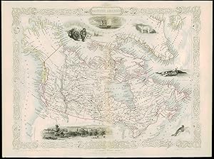
1850 "BRITISH AMERICA" CANADA GREENLAND Antique Map Tallis with Vignettes (11d)
Seller: Antique Paper Company, ASHFORD, KENT, United Kingdom
Seller rating 2 out of 5 stars

BRITISH AMERICA Drawn & engraved by John Rapkin for The Illustrated Atlas and Modern History of the World by Martin Montgomery. An attractive and decorative map of BRITISH AMERICA showing CANADA & NORTHERN ANTARCTIC AREAS, BRITISH COLUMBIA, RUSSIAN AMERICA, GREENLAND & ICELAND with vignette engravings of MONTREAL, WHALE FISHING, SEAL, ESQUIMAUX, FURY AND HECLA (Ships) & POLAR BEARS. Original outline hand colouring. An excellent exle of the preferred Montgomery Martin edition. Generally fine condition with the usual central fold. Approx 360mm x 280mm and printed on heavy grade paper. Perfect for mounting & framing. John Tallis is considered to be one of the most renowned cartographers and publisher of the C19th . His maps are considered to be the last of the lavishly decorated and ornamental maps, works of art as much of geography. He was born in Stourbridge in Worcestershire in about 1818 and it is possible he stayed working in the Midlands working as a publisher in Birmingham, until he moved to London in the early 1840�s.John then set up the first of his publishing businesses, in Cripplegate, with Frederick Tallis, who was quite possibly his brother. This business lasted from 1842 to 1849 when it was dissolved. By 1846 the business had moved to Smithfield.From 1851 �" 54, John set up another business, operating as John Tallis and Company and it was during this period that he produced the Illustrated World Atlas, produced for the 1851 Great Exhibition The intriguing thing is, that at some point, John Tallis made the acquaintance of an engraver called John Rapkin who was an inspiration to Tallis. His stunning illustrations enabled the maps they produced to be beautiful illumanitive works of art. John Rapkin�s work inspired John Tallis and they used travelogues extensively to guide Joh Rapkin as he produced vignettes and ornamental engravings to embelish the Tallis maps. All our items are original Antiques and as d.
-
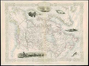
1850 "BRITISH AMERICA" CANADA GREENLAND Antique Map Tallis with Vignettes (11d)
Seller: Antique Paper Company, ASHFORD, KENT, United Kingdom
Seller rating 2 out of 5 stars
Map Signed
No Binding. Condition: Fine. No Jacket. 1850 "BRITISH AMERICA" CANADA GREENLAND Antique Map Tallis with Vignettes (11d) For more info please ask seller a question. Royal Mail 2nd Class - �0.00 Royal Mail 2nd Class Signed For - �4.50 Standard Int'l age - �4.00 Royal Mail International Signed - �8.00 No PICK UP OPTIONSorry, our items are NOT available for pick-up.PAYING VIA PAYPALWe accept on our all our items so you can shop with confidence.Simple choose the option when proceeding through the checkout.