
Order Total (1 Item Items):
Shipping Destination:

Thames River Map Stanford (2 results)
Skip to main search results
Search filters
Product Type
- All Product Types
- Books (2)
- Magazines & Periodicals (No further results match this refinement)
- Comics (No further results match this refinement)
- Sheet Music (No further results match this refinement)
- Art, Prints & Posters (No further results match this refinement)
- Photographs (No further results match this refinement)
- Maps (No further results match this refinement)
- Manuscripts & Paper Collectibles (No further results match this refinement)
Condition Learn more
- New (No further results match this refinement)
- As New, Fine or Near Fine (No further results match this refinement)
- Very Good or Good (No further results match this refinement)
- Fair or Poor (No further results match this refinement)
- As Described (2)
Binding
- All Bindings
- Hardcover (2)
- Softcover (No further results match this refinement)
Collectible Attributes
- First Edition (No further results match this refinement)
- Signed (No further results match this refinement)
- Dust Jacket (No further results match this refinement)
- Seller-Supplied Images (2)
- Not Print on Demand (2)
Language (1)
Price
- Any Price
- Under � 20 (No further results match this refinement)
- � 20 to � 35 (No further results match this refinement)
- Over � 35
Free Shipping
- Free Shipping to U.S.A. (No further results match this refinement)
Seller Location
Seller Rating
-
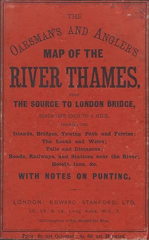
THE OARSMAN'S AND ANGLER'S MAP OF THE RIVER THAMES from the Source to London Bridge. One inch to a mile.
Published by Edward Stanford, Ltd. London. 1912, 1912
Seller: Coch-y-Bonddu Books Ltd, MACHYNLLETH, United Kingdom
Association Member: PBFA
Seller rating 5 out of 5 stars

ALL UK PARCELS SENT TRACKED! ALL OVERSEAS PARCELS SENT AIRMAIL, TRACKED! (S/hand, Hardcover, 1912). 1912. 12mo (115 x 165mm). 20 pp of text. Coloured folding paper map, (820mm x 575mm). Green cloth case with orange paper title label covering upper board. Sellotape repairs to map, some browning but good. The Oarsman's And Angler's Map Of The River Thames, from the source to London Bridge, scale one inch to a mile, shewing the islands, bridges, towing path and ferries; the locks and weirs; tolls and distances; roads, railways, and stations near the river; hotels, inns, &c., with notes on punting. Map dated 1912, but the notes pages refer to bye-laws made in January 1914. "Price: 2s. net Coloured; 4s. 6d. net Mounted." This is the cheaper coloured paper version. .
-
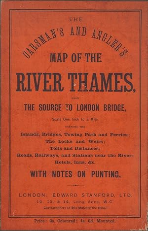
THE OARSMAN'S AND ANGLER'S MAP OF THE RIVER THAMES from the Source to London Bridge. One inch to a mile.
Published by Edward Stanford, Ltd. London. 1912, 1912
Seller: Coch-y-Bonddu Books Ltd, MACHYNLLETH, United Kingdom
Association Member: PBFA
Seller rating 5 out of 5 stars
ALL UK PARCELS SENT TRACKED! ALL OVERSEAS PARCELS SENT AIRMAIL, TRACKED! (S/hand, Hardcover, 1912). 1912. 12mo (115 x 165mm). 20 pp of text. Coloured folding paper map, (820mm x 575mm). Green cloth case with orange paper title label covering upper board. One small tear to map, some browning but very good. The Oarsman's And Angler's Map Of The River Thames, from the source to London Bridge, scale one inch to a mile, shewing the islands, bridges, towing path and ferries; the locks and weirs; tolls and distances; roads, railways, and stations near the river; hotels, inns, &c., with notes on punting. Map dated 1912, but the notes pages refer to bye-laws made in January 1914. "Price: 2s. net Coloured; 4s. 6d. net Mounted." This is the cheaper coloured paper version. .