Order Total (1 Item Items):
Shipping Destination:

Teesdale Henry (85 results)
Skip to main search results
Search filters
Product Type
- All Product Types
- Books (67)
- Magazines & Periodicals (No further results match this refinement)
- Comics (No further results match this refinement)
- Sheet Music (No further results match this refinement)
- Art, Prints & Posters (No further results match this refinement)
- Photographs (No further results match this refinement)
- Maps (18)
- Manuscripts & Paper Collectibles (No further results match this refinement)
Condition Learn more
- New (5)
- As New, Fine or Near Fine (1)
- Very Good or Good (8)
- Fair or Poor (No further results match this refinement)
- As Described (71)
Binding
Collectible Attributes
- First Edition (2)
- Signed (1)
- Dust Jacket (No further results match this refinement)
- Seller-Supplied Images (74)
- Not Print on Demand (82)
Language (2)
Free Shipping
Seller Location
Seller Rating
-

Narrative of the Defence of Kars, Historical and Military. from Documents and Notes Taken by the Several Officers Serving on the Staff of Her ... Lieut. Col. C. Teesdale C.B., and W. Simpson.
Language: English
Published by British Library, Historical Print Editions, 2011
ISBN 10: 124143428X ISBN 13: 9781241434281
Seller: Ria Christie Collections, Uxbridge, United Kingdom
Seller rating 5 out of 5 stars

� 22.49
� 11.98 shipping
Ships from United Kingdom to U.S.A.Quantity: Over 20 available
Add to basketCondition: New. In.
-

Narrative of the Defence of Kars, historical and military. From Documents and Notes taken by the several Officers serving on the Staff of Her Majesty s Commissioner with the Ottoman Army in Asia Minor. Lieut. Col. C. Teesdale C.B., and W. Simpson.
Language: English
Published by British Library, Historical Print Editions, 2011
ISBN 10: 124143428X ISBN 13: 9781241434281
Condition: New.
-

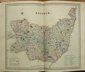
Single sheet. Original fine outline colouring with woods in green 19 x 15 cm.
-
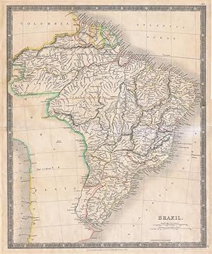
Brazil.
Published by From A New General Atlas of the World, 1834, 1834
Seller: Pennymead Books PBFA, Knaresborough, United Kingdom
Association Member: PBFA
Seller rating 5 out of 5 stars
Large engraved map with hand coloured outline. Fine. 15 x 18" Also showing Paraguay.
-
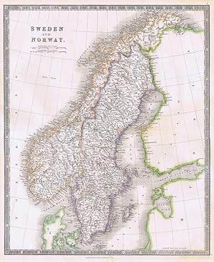
Sweden and Norway.
Published by From A New General Atlas of the World, 1834, 1834
Seller: Pennymead Books PBFA, Knaresborough, United Kingdom
Association Member: PBFA
Seller rating 5 out of 5 stars
Large engraved map with hand coloured outline. Fine. 15 x 18".
-
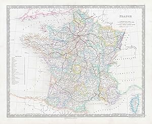
1850 FRANCE World Original Antique Map by Henry Teesdale (TNGA-12)
Seller: Antique Paper Company, ASHFORD, KENT, United Kingdom
Seller rating 2 out of 5 stars

1850 Original antique map titled FRANCE published by Henry Teesdale. Published for A NEW GENERAL ATLAS OF THE WORLD Compiled and Constructed with the Greatest Care from the Documents in the Foreign, Colonial, and Admiralty Offices, also those of the Honourable the East India Company. Condition is very good with central fold, as issued and with original outline hand colouring. Overall size approx 45.4cm x 38cm including margins.Antique Paper Company are a long established family business selling original antique prints, maps engravings as well as many other paper antiques such as original vintage Decorative Posters, Ephemera, Stamps Postal History, Manuscripts, Antiquarian Books much more. We are always looking to buy and have substantial immediate funds available. We are looking for exceptional single items, better collections, original archives, Atlases, Libraries, accumulations etc and have previously purchased from Major Institutions, Libraries, Collectors, Solicitors many other sources. We are happy to travel almost anywhere in the world for the right opportunities. So please do get in touch if you are considering selling your Antique Paper collectables.
-

1850 AUSTRIAN EMPIRE World Original Antique Map by Henry Teesdale (TNGA-16)
Seller: Antique Paper Company, ASHFORD, KENT, United Kingdom
Seller rating 2 out of 5 stars
1850 Original antique map titled AUSTRIAN EMPIRE published by Henry Teesdale. Published for A NEW GENERAL ATLAS OF THE WORLD Compiled and Constructed with the Greatest Care from the Documents in the Foreign, Colonial, and Admiralty Offices, also those of the Honourable the East India Company. Condition is very good with central fold, as issued and with original outline hand colouring. Overall size approx 45.4cm x 38cm including margins.Antique Paper Company are a long established family business selling original antique prints, maps engravings as well as many other paper antiques such as original vintage Decorative Posters, Ephemera, Stamps Postal History, Manuscripts, Antiquarian Books much more. We are always looking to buy and have substantial immediate funds available. We are looking for exceptional single items, better collections, original archives, Atlases, Libraries, accumulations etc and have previously purchased from Major Institutions, Libraries, Collectors, Solicitors many other sources. We are happy to travel almost anywhere in the world for the right opportunities. So please do get in touch if you are considering selling your Antique Paper collectables.
-
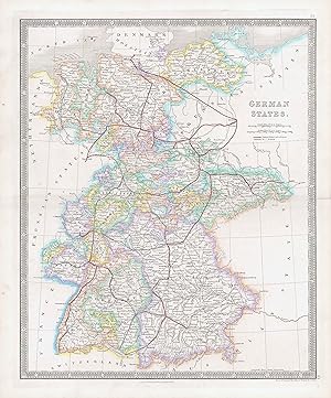
1850 GERMAN STATES World Original Antique Map by Henry Teesdale (TNGA-15)
Seller: Antique Paper Company, ASHFORD, KENT, United Kingdom
Seller rating 2 out of 5 stars
1850 Original antique map titled GERMAN STATES published by Henry Teesdale. Published for A NEW GENERAL ATLAS OF THE WORLD Compiled and Constructed with the Greatest Care from the Documents in the Foreign, Colonial, and Admiralty Offices, also those of the Honourable the East India Company. Condition is very good with central fold, as issued and with original outline hand colouring. Overall size approx 45.4cm x 38cm including margins.Antique Paper Company are a long established family business selling original antique prints, maps engravings as well as many other paper antiques such as original vintage Decorative Posters, Ephemera, Stamps Postal History, Manuscripts, Antiquarian Books much more. We are always looking to buy and have substantial immediate funds available. We are looking for exceptional single items, better collections, original archives, Atlases, Libraries, accumulations etc and have previously purchased from Major Institutions, Libraries, Collectors, Solicitors many other sources. We are happy to travel almost anywhere in the world for the right opportunities. So please do get in touch if you are considering selling your Antique Paper collectables.
-
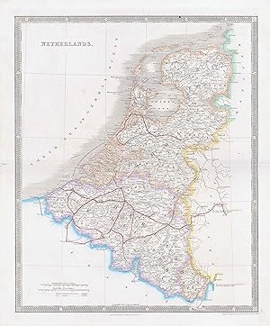
1850 NETHERLANDS World Original Antique Map by Henry Teesdale (TNGA-11)
Seller: Antique Paper Company, ASHFORD, KENT, United Kingdom
Seller rating 2 out of 5 stars
1850 Original antique map titled NETHERLANDS published by Henry Teesdale. Published for A NEW GENERAL ATLAS OF THE WORLD Compiled and Constructed with the Greatest Care from the Documents in the Foreign, Colonial, and Admiralty Offices, also those of the Honourable the East India Company. Condition is very good with central fold, as issued and with original outline hand colouring. Overall size approx 45.4cm x 38cm including margins.Antique Paper Company are a long established family business selling original antique prints, maps engravings as well as many other paper antiques such as original vintage Decorative Posters, Ephemera, Stamps Postal History, Manuscripts, Antiquarian Books much more. We are always looking to buy and have substantial immediate funds available. We are looking for exceptional single items, better collections, original archives, Atlases, Libraries, accumulations etc and have previously purchased from Major Institutions, Libraries, Collectors, Solicitors many other sources. We are happy to travel almost anywhere in the world for the right opportunities. So please do get in touch if you are considering selling your Antique Paper collectables.
-
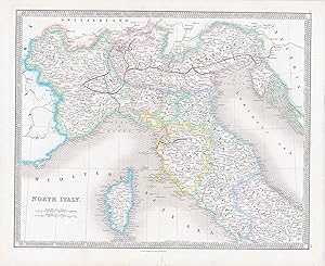
1850 NORTH ITALY World Original Antique Map by Henry Teesdale (TNGA-18)
Seller: Antique Paper Company, ASHFORD, KENT, United Kingdom
Seller rating 2 out of 5 stars
1850 Original antique map titled NORTH ITALY published by Henry Teesdale. Published for A NEW GENERAL ATLAS OF THE WORLD Compiled and Constructed with the Greatest Care from the Documents in the Foreign, Colonial, and Admiralty Offices, also those of the Honourable the East India Company. Condition is very good with central fold, as issued and with original outline hand colouring. Overall size approx 45.4cm x 38cm including margins.Antique Paper Company are a long established family business selling original antique prints, maps engravings as well as many other paper antiques such as original vintage Decorative Posters, Ephemera, Stamps Postal History, Manuscripts, Antiquarian Books much more. We are always looking to buy and have substantial immediate funds available. We are looking for exceptional single items, better collections, original archives, Atlases, Libraries, accumulations etc and have previously purchased from Major Institutions, Libraries, Collectors, Solicitors many other sources. We are happy to travel almost anywhere in the world for the right opportunities. So please do get in touch if you are considering selling your Antique Paper collectables.
-
1850 SWITZERLAND World Original Antique Map by Henry Teesdale (TNGA-14)
Seller: Antique Paper Company, ASHFORD, KENT, United Kingdom
Seller rating 2 out of 5 stars
1850 Original antique map titled SWITZERLAND published by Henry Teesdale. Published for A NEW GENERAL ATLAS OF THE WORLD Compiled and Constructed with the Greatest Care from the Documents in the Foreign, Colonial, and Admiralty Offices, also those of the Honourable the East India Company. Condition is very good with central fold, as issued and with original outline hand colouring. Overall size approx 45.4cm x 38cm including margins.Antique Paper Company are a long established family business selling original antique prints, maps engravings as well as many other paper antiques such as original vintage Decorative Posters, Ephemera, Stamps Postal History, Manuscripts, Antiquarian Books much more. We are always looking to buy and have substantial immediate funds available. We are looking for exceptional single items, better collections, original archives, Atlases, Libraries, accumulations etc and have previously purchased from Major Institutions, Libraries, Collectors, Solicitors many other sources. We are happy to travel almost anywhere in the world for the right opportunities. So please do get in touch if you are considering selling your Antique Paper collectables.
-

A New Chart of the World on Mercator's Projection with the Tracks of the Most Celebrated and Recent Navigators.
Published by LondonHenry Teesdale ., 1845
Seller: Robert Frew Ltd. ABA ILAB, London, United Kingdom
Association Member: ABA ILAB PBFA
Seller rating 5 out of 5 stars
Map
Original large-format map of the world on Mercator's projection (130 x 198 cm), engraved by John Dower and with fine original colour, sectionalised and laid onto two sections of linen as issued, each edged with green silk and measuring 130 x 99 cm, folding between publisher's original morocco covers (38 x 27 cm) with gilt foliate frame enclosing gilt title, marbled endpapers. Some very faint occasional foxing, upper cover with scratch mark to lower centre, overall a particularly fine example of this impressive map. Fine large format map of the world, which provides fantastic detail throughout, engraved by John Dower and published by Henry Teesdale. It is one of the few English maps to recognise the Republic of Texas (England itself did not), and depict its most ambitious boundaries. It is also the most complete map to show a complete northwest passage following the Deese-Simpson Expedition. Perhaps the most interesting part of the map is its treatment of the search for the Northwest Passage and the extensive annotations showing the routes of various discoverers throughout the world. With respect to the Northwest Passage, there are dozens of annotations identifying the British and other discoveries in the region, with section of text describing Arctic exploration up to 1833 and then additional notes on the map discussing discoveries up to October 1839, noting: "This Coast was Explored by Messrs. Dease and Simpson under the Honble. Hudson's Bay Company which completes the North West Passage Octr. 1839" Off the coast of Alaska, a number of different tracks of exploration are shown, up to Captain Beechey in 1826, with a further note in the interior further discussing P.W. Deawe and Thos. Simpson's expedition beginning at Fort Chipewyan June 1, 1837, traveling north to the Arctic Sea and then to Alaska. In the Southern Hemisphere, there are a number of early Antarctic discoveries shown. Teesdale was a London-based map publisher. He was an early Fellow of the Royal Geographical Society, elected in 1830. Teesdale partnered with John Hordan and William Colling Hodson, but this arrangement dissolved in 1832. Afterward, he continued to work on his own and periodically with colleagues like John Crane Dower, Christopher Greenwood, Josiah Henshall and others. He published a variety of atlases and separately-issued maps. His business was quite successful, as he registered as a partner in the Royal Bank of Scotland in 1845.
-

New British Atlas
Published by London, 1830
Seller: Clive A. Burden Ltd., Chalfont St. Giles, BUCKS, United Kingdom
Seller rating 5 out of 5 stars
No binding. Large folio (480 x 380 mm.), full contemporary calf with inset marbled paper within gilt panels on both covers, upper cover bearing an ornate gilt calf title label. An extensively gilded spine. With engraved title and 45 early wash coloured maps, the Yorkshire in four sheets. Folding maps of England & Wales, Ireland and Scotland, with general maps of North and South Wales. With some foxing to the general maps and Middlesex with a margin tear repaired. First published in 1829 the title page of this edition states that the 'whole [is] carefully revised & corrected to the year, 1830.' In fact the first true use of the plates was in Robert Rowe's 'English Atlas' published in 1816. Only two examples of that atlas survive. Rowe (c.1775-1843) is recorded as an engraver and it is possible that he was responsible for these plates. It was Henry Teesdale (fl.1828-45) however who made the most use of the plates with the 'New British Atlas' being published through 1842. Provenance: bookplate of W D MacKenzie at Fawley Court inside cover; Heathcote Ball & Co., auction 25 July 1991 lot 490; from a private English Collection. Beresiner pp. 190 & 227-9; Carroll 71; Chubb 410.
-
A Map of the County Palatine of Lancaster Divided into Hundreds and Parishes from an accurate Survey made in the Years 1828 and 1829.
Published by Henry Teesdale & Co, London, 1830
Linen. Condition: Good. Early Edition. Large engraved folding map, hand-coloured in hundreds, with an engraved inset view of the New Custom House, Liverpool. Published by Henry Teesdale & Co., May 1. 1830. Dissected and mounted on linen, edged in green cloth, With original pull-off slipcase, marbled edges, spine label still intact. 1160mm x 1640mm. A fine map of the county in a scale of 3/4 inch to 1 mile, engraved by J. Bingley. Previous owner name to slip case and rear of map. Slipcase worn, cloth edging slightly worn and loosening in a couple of places, colours still nice and bright. Quantity Available: 1. Shipped Weight: Under 2 kilogram. Category: Geography & Maps; History. Pictures of this item not already displayed here available upon request. Inventory No: 3958. This map weighs over 1Kg and may involve extra shipping charges to some countries.
-
A Travelling Atlas, containing a complete Set of County Maps, on which are Delineated all the Mail & Turnpike Roads, The Cities, Towns .
Published by Henry Teesdale & Co. 2 Brunswick Row, Queen Sqe. and Sold by D. W. Marti, 16 Westmoreland Place, City Road, London, 1843
Seller: Clive A. Burden Ltd., Chalfont St. Giles, BUCKS, United Kingdom
Seller rating 5 out of 5 stars
No binding. Quarto (235 x 185 mm.), nineteenth century half red calf, red cloth boards with gilt 'Atlas' embossed to upper board, ornate blind ruled and gilt decorated spine with title, light wear. With early endpapers, engraved title page, engraved Contents leaf and 45 engraved maps including 1 large folding general map of England and Wales with minor tear where bound in and 44 single page maps of North and South Wales and the English counties, all in early wash colour, in good condition. Henry Teesdale (fl.1828-45) a successful publisher in London is best known for two English County atlases. In 1829 he acquired the county plates to Robert Rowe's exceedingly rare 'English Atlas' and after revision published them as the 'New British Atlas'. Encouraged by its undoubted success he embarked on a reduced sized county atlas which he published the following year entitled 'A New Travelling Atlas'. In this work the roads are made the principal feature. The engraved title page bears an attractive vignette above the imprint displaying five cherubs being educated in geography. The maps bear a distinct piano keyboard design. For some reason it was not a great success, at least judging from the fact that only two examples survive: Cambridge University Library and a private English collection. For the second edition in 1843, plate numbers were added, as were railways in the counties where they had been introduced. It appears that he took in a partner D. W. Martin which might explain the possible delay in publication. Chubb pointed out that the Cambridge map bears the London to Cambridge Railway which was officially opened July 1845. This later title page bears across the top 'This Edition Contains All The Railways'. We have identified two issues of this edition, this being the earlier one. The later issue bears the latest railways added to several maps. Only A HANDFUL OF EXAMPLES survive. Provenance: manuscript ownership marks of 'Mark Wm. Hunter from Mark Woodhouse' '- 'Re-bound 1888', all in the same hand. Burgess (2004) no. 124.ii; Carroll (1996) no. 92.2; refer Chubb (1927) no. 418; Worms & Baynton-Williams (2011).
-
New British Atlas, Containing a Complete Set of County Maps
Published by Henry Teesdale & Co. 302, Holborn, London, 1831
Seller: Clive A. Burden Ltd., Chalfont St. Giles, BUCKS, United Kingdom
Seller rating 5 out of 5 stars
No binding. Large quarto (365 x 255 mm.), full contemporary diced calf, ornate blind and gilt panelled, ribbed spine with ornate gilt raised bands, gilt title and gilt edged, marbled endpapers. With double page engraved title corrected to 1831, three folding general maps backed on contemporary cloth, 2 double page maps of North & South Wales, 43 county maps, and a folding map showing parliamentary representation in England & Wales for June 1832 backed on publisher's linen, all in early wash colour, Somerset with centrefold split, otherwise a good example. The first true use of this series of plates was in Robert Rowe's 'English Atlas' published in 1816. Only two examples of that atlas survive. Rowe (c.1775-1843) was a publisher and engraver but it is as the latter that he is most noted. It is possible that he both drew and engraved the maps in 'The English Atlas'. Amongst his earliest works are the engraving of two sets of playing cards of the English Counties. Both are exceedingly rare; those of John Fairburn, 1798, and Joseph Allen, 1811. Rowe continued selling the county maps until at least 1825. The date of their acquisition by Henry Teesdale (1776-1855) is not known. Born in London, his first known publication was a reissue of Christopher Greenwood's large-scale map of Yorkshire in 1828. Teesdale was elected a fellow of the Royal Geographical Society shortly after its foundation in 1830. The earliest known edition of this work is 1829, the date of issue is derived from the wording of the title 'the whole carefully revised & corrected to the year, 1829.' It was published in partnership with John Jordan and William Colling Hobson as Henry Teesdale & Co. All reference to Rowe is removed and Teesdale's imprint added to each map. A new larger general map of England and Wales replaces the earlier one and two matching maps of Scotland and Ireland are added. The oval titles to each of the maps are replaced with a simple county name. The early railways in Durham, Lancashire, and Surrey are included.There were ensuing editions similarly dated 1830 and as here 1831. All three issues contain gradual improvements and alterations to the plates. The Reform Bill of 1832 introduced big changes in the electoral system in England and Wales. Prior to the Bill the population electing each member varied considerably. Many rural areas were very small and dominated by powerful landowners. Since the industrial revolution, several large cities now had very large populations. This power was now more evenly distributed, and the electorate increased from about 400,000 to 650,000, or about one in five adult males.This example is a late issue as it includes bound into the end a large folding map illustrating the new parliamentary representation in England & Wales for June 1832. It includes an inset plate of London with the Boroughs coloured individually. Major revisions to the plates themselves in the next edition would reflect this new data. The atlas continued to be published through 1842. Provenance: inscription on the recto of the title 'E J Gratrex Davies April 29th 1897' most likely the prominent barrister (1848-99); cute poem affixed on front free endpaper by 'Gratrex Davies'; Clive A. Burden Ltd., July 2000; private English collection. Beresiner (1983) pp. 190 & 227-9; Carroll (1996) 71; Chubb (1927) 414; Smith (1982); Tooley's Dictionary (1999-2004); Worms & Baynton-Williams (2011).
-
A Travelling Atlas : Containing a Complete Set of County Maps, on Which are Delineated all the Mail & Turnpike Roads, The Cities, Towns .
Published by Henry Teesdale & Co. 1843, London, 1843
Seller: Foster Books - Stephen Foster - ABA, ILAB, & PBFA, London, United Kingdom
Association Member: ABA ILAB PBFA
Seller rating 5 out of 5 stars
Full Leather. Condition: Very Good. (iii), + 45 plates, pp. Contemporary decoratively embossed black leather with gilt title panel to front board. New black morocco spine. All edges gilt. Slight wear to corners and board edges. Early ownership stamp to front pastedown & endpaper. Early ink name to rear free endpaper. Engraved title-page with vignette. With forty-five full-page colour maps, including one folding. Plates complete. A few minor light stains to some plates. The maps show roads and railways. OCLC records just Cambridge for this edition, with copies of the 1830 edition in the BL, Cambs & Newberry Library, Chicago. Very scarce. This atlas appears to have been a commercial failure. Perhaps because it followed Teesdale's successful 'New British Atlas', published only the year before. This later edition emphasises the roads and the newly emerging railway network. Small 4to.
-
A New General Atlas of the World, Compiled from the Latest authorities Both English and Foreign, Containing separate Maps of its Various Countries and States, and exhibiting their Boundaries & Divisions, also the Chains of Mountains, Rivers
Published by Henry Teesdale, London, 1837
Seller: Arader Galleries - AraderNYC, New York, NY, U.S.A.
Seller rating 5 out of 5 stars
A New General Atlas of the World, Compiled from the latest authorities both English and Foreign, Containing separate Maps of it various Countries and States, and exhibiting their Boundaries & Divisions, also the Chains of Mountains, Rivers, Lakes and other Geographical Features comprehended in forty seven Maps. Folio (14 3/4 x 10 in.; 37.5 x 25.4 cm). Engraved title-page, engraved list of contents, 47 engraved maps, with contemporary handcolring in outline; double-page map of India reinforced along folds and trimmed close along right margin. Half green morocco over green moir� textured cloth, smooth spine gilt; corners bumped and rubbed. THESE HISTORICALLY SIGNIFICANT MAPS show the full extent of the British Empire in the early nineteenth century and after the Treaty of Paris. The detailed folding map of India reflects the lands controlled by the British East India Company as well as those of other European powers and the map of the Americas show the Fifty-Four Forty or Fight border with the United States extending into the area of British America. Henry Teesdale was a prominent London publisher and a foudning fellow of the Royal Geographical Society. REFERENCE: Cf. Phillips 773 (1835 edition with 46 maps).
-
A New Chart of the World on Mercator's Projection, with the Tracks of the Most Celebrated Recent Navigators.
Published by London: Henry Teesdale, 1842., 1842
Seller: Arader Galleries - AraderNYC, New York, NY, U.S.A.
Seller rating 5 out of 5 stars
Signed
Hardcover. Condition: Very Good. Large folding engraved wall map two separate sheets (each 51 x 38 4/8 inches), each laid down on cartographic linen in 16 sections, with original hand-colour in full, showing the tracks of major explorers from Tasman to Briscoe, compass roses, a table of Explanation of bearings and distances, and a table of Distances, both lower right, edged in green silk (a bit browned at folds, some loss to edging). A fine large wall map showing the tracks of the major explorers to the mid 1830s, with other interesting and important events noted. British recognition of the Republic of Texas in November of 1840 is recorded, although James Hamilton was only able to agree three treaties with the British at this stage. These were related to commerce and navigation, a second provided for British mediation in the Texas-Mexico difficulties concerning peace, and a third called for the suppression of slave trade, and though signed in November 1840, because of various delays ratifications were not actually exchanged until July 28, 1842. The new boundary between the British Possessions in North America and the United States which was only decided as recently as April of 1842 with the signing of the Webster-Ashburton Treaty is recorded. "This treaty settled many long-standing issues between the United States and England that by 1842 had become acute. These included U.S.-Canadian boundary disputes; the 1837 burning by Canadians of a U.S. steamship, the Caroline, in the Niagara River, with the death of a crewman; the 1840 arrest in New York State of a Canadian, Alexander McLeod, accused of involvement in the Caroline affair; and the refusal of British authorities to return to the United States the African-American slaves who in 1841 had seized and diverted to the Bahamas a U.S. brig, the Creole, transporting them from Virginia to New Orleans.The Webster-Ashburton Treaty granted the United States nearly 60 percent of the disputed area in the Northeast, including a strategic military location at the top of Lake Champlain, along with a region west of Lake Superior, Minnesota's Mesabi Range, that later proved rich in iron ore. It also allowed Americans to turn westward and encouraged what proved to be an enduring Anglo-American rapprochement". Joseph W. Schmitz for Texas State Historical Association online. Signed by Author(s).
-

Scotland.
Published by London: Published by Henry Teesdale., [c. 1830]., 1830
Seller: Spike Hughes Rare Books ABA, Innerleithen, United Kingdom
Seller rating 5 out of 5 stars
Map
Engraved map, approx. 645 X 530 mm., hand-coloured, dissected, mounted on linen.
-
1850 GREECE World Original Antique Map by Henry Teesdale (TNGA-21)
Seller: Antique Paper Company, ASHFORD, KENT, United Kingdom
Seller rating 2 out of 5 stars
1850 Original antique map titled GREECE published by Henry Teesdale. Published for A NEW GENERAL ATLAS OF THE WORLD Compiled and Constructed with the Greatest Care from the Documents in the Foreign, Colonial, and Admiralty Offices, also those of the Honourable the East India Company. Condition is very good with central fold, as issued and with original outline hand colouring. Overall size approx 45.4cm x 38cm including margins.Antique Paper Company are a long established family business selling original antique prints, maps engravings as well as many other paper antiques such as original vintage Decorative Posters, Ephemera, Stamps Postal History, Manuscripts, Antiquarian Books much more. We are always looking to buy and have substantial immediate funds available. We are looking for exceptional single items, better collections, original archives, Atlases, Libraries, accumulations etc and have previously purchased from Major Institutions, Libraries, Collectors, Solicitors many other sources. We are happy to travel almost anywhere in the world for the right opportunities. So please do get in touch if you are considering selling your Antique Paper collectables.
-
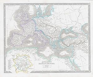
1850 ROMAN EMPIRE World Original Antique Map by Henry Teesdale (TNGA-43)
Seller: Antique Paper Company, ASHFORD, KENT, United Kingdom
Seller rating 2 out of 5 stars
1850 Original antique map titled ANCIENT ROMAN EMPIRE published by Henry Teesdale. Published for A NEW GENERAL ATLAS OF THE WORLD Compiled and Constructed with the Greatest Care from the Documents in the Foreign, Colonial, and Admiralty Offices, also those of the Honourable the East India Company. Condition is very good with central fold, as issued and with original outline hand colouring. Overall size approx 45.4cm x 38cm including margins.Antique Paper Company are a long established family business selling original antique prints, maps engravings as well as many other paper antiques such as original vintage Decorative Posters, Ephemera, Stamps Postal History, Manuscripts, Antiquarian Books much more. We are always looking to buy and have substantial immediate funds available. We are looking for exceptional single items, better collections, original archives, Atlases, Libraries, accumulations etc and have previously purchased from Major Institutions, Libraries, Collectors, Solicitors many other sources. We are happy to travel almost anywhere in the world for the right opportunities. So please do get in touch if you are considering selling your Antique Paper collectables.
-

1850 PERU BOLIVIA World Original Antique Map by Henry Teesdale (TNGA-39)
Seller: Antique Paper Company, ASHFORD, KENT, United Kingdom
Seller rating 2 out of 5 stars
1850 Original antique map titled PERU AND BOLIVIA published by Henry Teesdale. Published for A NEW GENERAL ATLAS OF THE WORLD Compiled and Constructed with the Greatest Care from the Documents in the Foreign, Colonial, and Admiralty Offices, also those of the Honourable the East India Company. Condition is very good with central fold, as issued and with original outline hand colouring. Overall size approx 45.4cm x 38cm including margins.Antique Paper Company are a long established family business selling original antique prints, maps engravings as well as many other paper antiques such as original vintage Decorative Posters, Ephemera, Stamps Postal History, Manuscripts, Antiquarian Books much more. We are always looking to buy and have substantial immediate funds available. We are looking for exceptional single items, better collections, original archives, Atlases, Libraries, accumulations etc and have previously purchased from Major Institutions, Libraries, Collectors, Solicitors many other sources. We are happy to travel almost anywhere in the world for the right opportunities. So please do get in touch if you are considering selling your Antique Paper collectables.
-
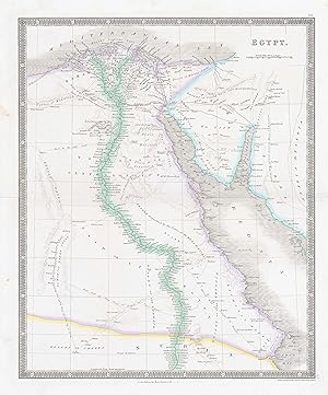
1850 EGYPT World Original Antique Map by Henry Teesdale (TNGA-32)
Seller: Antique Paper Company, ASHFORD, KENT, United Kingdom
Seller rating 2 out of 5 stars
1850 Original antique map titled EGYPT published by Henry Teesdale. Published for A NEW GENERAL ATLAS OF THE WORLD Compiled and Constructed with the Greatest Care from the Documents in the Foreign, Colonial, and Admiralty Offices, also those of the Honourable the East India Company. Condition is very good with central fold, as issued and with original outline hand colouring. Overall size approx 45.4cm x 38cm including margins.Antique Paper Company are a long established family business selling original antique prints, maps engravings as well as many other paper antiques such as original vintage Decorative Posters, Ephemera, Stamps Postal History, Manuscripts, Antiquarian Books much more. We are always looking to buy and have substantial immediate funds available. We are looking for exceptional single items, better collections, original archives, Atlases, Libraries, accumulations etc and have previously purchased from Major Institutions, Libraries, Collectors, Solicitors many other sources. We are happy to travel almost anywhere in the world for the right opportunities. So please do get in touch if you are considering selling your Antique Paper collectables.
-
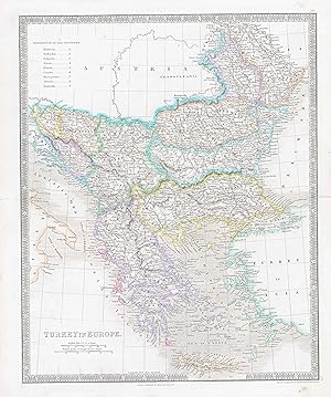
1850 TURKEY World Original Antique Map by Henry Teesdale (TNGA-20)
Seller: Antique Paper Company, ASHFORD, KENT, United Kingdom
Seller rating 2 out of 5 stars
1850 Original antique map titled TURKEY IN EUROPE published by Henry Teesdale. Published for A NEW GENERAL ATLAS OF THE WORLD Compiled and Constructed with the Greatest Care from the Documents in the Foreign, Colonial, and Admiralty Offices, also those of the Honourable the East India Company. Condition is very good with central fold, as issued and with original outline hand colouring. Overall size approx 45.4cm x 38cm including margins.Antique Paper Company are a long established family business selling original antique prints, maps engravings as well as many other paper antiques such as original vintage Decorative Posters, Ephemera, Stamps Postal History, Manuscripts, Antiquarian Books much more. We are always looking to buy and have substantial immediate funds available. We are looking for exceptional single items, better collections, original archives, Atlases, Libraries, accumulations etc and have previously purchased from Major Institutions, Libraries, Collectors, Solicitors many other sources. We are happy to travel almost anywhere in the world for the right opportunities. So please do get in touch if you are considering selling your Antique Paper collectables.
-
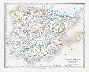
1850 SPAIN and PORTUGAL World Original Antique Map by Henry Teesdale (TNGA-13)
Seller: Antique Paper Company, ASHFORD, KENT, United Kingdom
Seller rating 2 out of 5 stars
1850 Original antique map titled SPAIN PORTUGAL published by Henry Teesdale. Published for A NEW GENERAL ATLAS OF THE WORLD Compiled and Constructed with the Greatest Care from the Documents in the Foreign, Colonial, and Admiralty Offices, also those of the Honourable the East India Company. Condition is very good with central fold, as issued and with original outline hand colouring. Overall size approx 45.4cm x 38cm including margins.Antique Paper Company are a long established family business selling original antique prints, maps engravings as well as many other paper antiques such as original vintage Decorative Posters, Ephemera, Stamps Postal History, Manuscripts, Antiquarian Books much more. We are always looking to buy and have substantial immediate funds available. We are looking for exceptional single items, better collections, original archives, Atlases, Libraries, accumulations etc and have previously purchased from Major Institutions, Libraries, Collectors, Solicitors many other sources. We are happy to travel almost anywhere in the world for the right opportunities. So please do get in touch if you are considering selling your Antique Paper collectables.
-
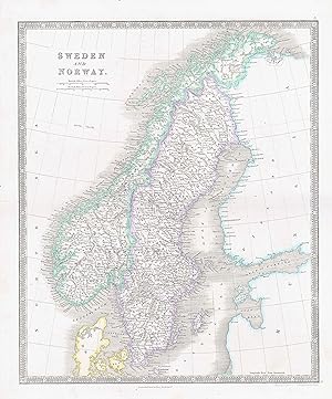
1850 SWEDEN AND NORWAY World Original Antique Map by Henry Teesdale (TNGA-8)
Seller: Antique Paper Company, ASHFORD, KENT, United Kingdom
Seller rating 2 out of 5 stars
1850 Original antique map titled SWEDEN AND NORWAY published by Henry Teesdale. Published for A NEW GENERAL ATLAS OF THE WORLD Compiled and Constructed with the Greatest Care from the Documents in the Foreign, Colonial, and Admiralty Offices, also those of the Honourable the East India Company. Condition is very good with central fold, as issued and with original outline hand colouring. Overall size approx 45.4cm x 38cm including margins.Antique Paper Company are a long established family business selling original antique prints, maps engravings as well as many other paper antiques such as original vintage Decorative Posters, Ephemera, Stamps Postal History, Manuscripts, Antiquarian Books much more. We are always looking to buy and have substantial immediate funds available. We are looking for exceptional single items, better collections, original archives, Atlases, Libraries, accumulations etc and have previously purchased from Major Institutions, Libraries, Collectors, Solicitors many other sources. We are happy to travel almost anywhere in the world for the right opportunities. So please do get in touch if you are considering selling your Antique Paper collectables.
-
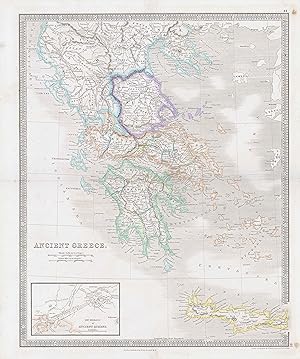
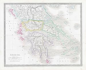
1850 ANCIENT GREECE World Original Antique Map by Henry Teesdale (TNGA-42)
Seller: Antique Paper Company, ASHFORD, KENT, United Kingdom
Seller rating 2 out of 5 stars
1850 Original antique map titled ANCIENT GREECE published by Henry Teesdale. Published for A NEW GENERAL ATLAS OF THE WORLD Compiled and Constructed with the Greatest Care from the Documents in the Foreign, Colonial, and Admiralty Offices, also those of the Honourable the East India Company. Condition is very good with central fold, as issued and with original outline hand colouring. Overall size approx 45.4cm x 38cm including margins.Antique Paper Company are a long established family business selling original antique prints, maps engravings as well as many other paper antiques such as original vintage Decorative Posters, Ephemera, Stamps Postal History, Manuscripts, Antiquarian Books much more. We are always looking to buy and have substantial immediate funds available. We are looking for exceptional single items, better collections, original archives, Atlases, Libraries, accumulations etc and have previously purchased from Major Institutions, Libraries, Collectors, Solicitors many other sources. We are happy to travel almost anywhere in the world for the right opportunities. So please do get in touch if you are considering selling your Antique Paper collectables.
-
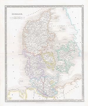
1850 DENMARK World Original Antique Map by Henry Teesdale (TNGA-10)
Seller: Antique Paper Company, ASHFORD, KENT, United Kingdom
Seller rating 2 out of 5 stars
1850 Original antique map titled DENMARK published by Henry Teesdale. Published for A NEW GENERAL ATLAS OF THE WORLD Compiled and Constructed with the Greatest Care from the Documents in the Foreign, Colonial, and Admiralty Offices, also those of the Honourable the East India Company. Condition is very good with central fold, as issued and with original outline hand colouring. Overall size approx 45.4cm x 38cm including margins.Antique Paper Company are a long established family business selling original antique prints, maps engravings as well as many other paper antiques such as original vintage Decorative Posters, Ephemera, Stamps Postal History, Manuscripts, Antiquarian Books much more. We are always looking to buy and have substantial immediate funds available. We are looking for exceptional single items, better collections, original archives, Atlases, Libraries, accumulations etc and have previously purchased from Major Institutions, Libraries, Collectors, Solicitors many other sources. We are happy to travel almost anywhere in the world for the right opportunities. So please do get in touch if you are considering selling your Antique Paper collectables.
-
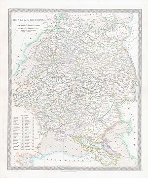
1850 RUSSIA IN EUROPE World Original Antique Map by Henry Teesdale (TNGA-9)
Seller: Antique Paper Company, ASHFORD, KENT, United Kingdom
Seller rating 2 out of 5 stars
1850 Original antique map titled RUSSIA IN EUROPE published by Henry Teesdale. Published for A NEW GENERAL ATLAS OF THE WORLD Compiled and Constructed with the Greatest Care from the Documents in the Foreign, Colonial, and Admiralty Offices, also those of the Honourable the East India Company. Condition is very good with central fold, as issued and with original outline hand colouring. Overall size approx 45.4cm x 38cm including margins.Antique Paper Company are a long established family business selling original antique prints, maps engravings as well as many other paper antiques such as original vintage Decorative Posters, Ephemera, Stamps Postal History, Manuscripts, Antiquarian Books much more. We are always looking to buy and have substantial immediate funds available. We are looking for exceptional single items, better collections, original archives, Atlases, Libraries, accumulations etc and have previously purchased from Major Institutions, Libraries, Collectors, Solicitors many other sources. We are happy to travel almost anywhere in the world for the right opportunities. So please do get in touch if you are considering selling your Antique Paper collectables.