
Order Total (1 Item Items):
Shipping Destination:

Standard Blue Print Map Engineering (13 results)
Skip to main search results
Search filters
Product Type
- All Product Types
- Books (13)
- Magazines & Periodicals (No further results match this refinement)
- Comics (No further results match this refinement)
- Sheet Music (No further results match this refinement)
- Art, Prints & Posters (No further results match this refinement)
- Photographs (No further results match this refinement)
- Maps (No further results match this refinement)
- Manuscripts & Paper Collectibles (No further results match this refinement)
Condition Learn more
- New (No further results match this refinement)
- As New, Fine or Near Fine (No further results match this refinement)
- Very Good or Good (No further results match this refinement)
- Fair or Poor (No further results match this refinement)
- As Described (13)
Binding
- All Bindings
- Hardcover (No further results match this refinement)
- Softcover (No further results match this refinement)
Collectible Attributes
- First Edition (No further results match this refinement)
- Signed (No further results match this refinement)
- Dust Jacket (No further results match this refinement)
- Seller-Supplied Images (13)
- Not Print on Demand (13)
Language (1)
Price
- Any Price
- Under � 20 (No further results match this refinement)
- � 20 to � 35 (No further results match this refinement)
- Over � 35
Free Shipping
- Free Shipping to U.S.A. (No further results match this refinement)
Seller Location
Seller Rating
-
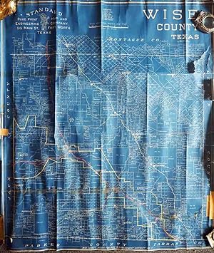
Wise County, Texas
Published by Fort Worth c.1950, Fort Worth, 1950
Seller: High Ridge Books, Inc. - ABAA, South Deerfield, MA, U.S.A.
Association Member: ABAA ESA ILAB SNEAB
Seller rating 5 out of 5 stars

Unbacked blueprint-style map of this county northwest of Ft. Worth. Fair condition, with some loss at the right side and bottom right corner. Crude tape repairs to one long horizontal tear on the front and other tears on the verso. One railroad and some town boundaries outlined in color. The key at the top defines the symbols used for various oil drilling sites, whether producing, drilling, a dry hole or abandoned.
-
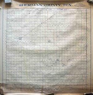
Sherman County, Texas
Published by Fort Worth c.1950, Fort Worth, 1950
Seller: High Ridge Books, Inc. - ABAA, South Deerfield, MA, U.S.A.
Association Member: ABAA ESA ILAB SNEAB
Seller rating 5 out of 5 stars
Unbacked map of this county on the northern boundary of the Texas panhandle. Excellent condtion. Some areas have manuscript outline color. Land owners and drilling rights holders identified.The key at the top defines the symbols used for various oil drilling sites, whether producing, drilling, a dry hole or abandoned.
-
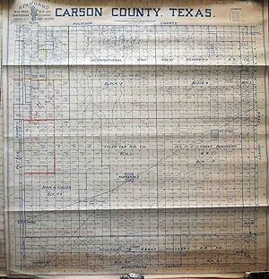
Carson County, Texas
Published by Fort Worth c.1950, Fort Worth, 1950
Seller: High Ridge Books, Inc. - ABAA, South Deerfield, MA, U.S.A.
Association Member: ABAA ESA ILAB SNEAB
Seller rating 5 out of 5 stars
Unbacked map of this county in the Texas panhandle east of Amarillo. Excellent condtion. Some areas have manuscript outline color. Land owners and drilling rights holders identified.The key at the top defines the symbols used for various oil drilling sites, whether producing, drilling, a dry hole or abandoned.
-
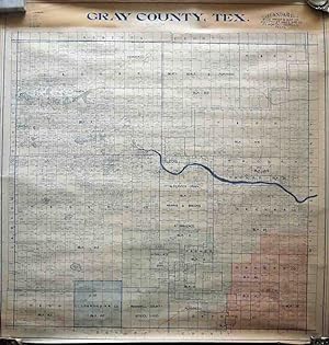
Gary County, Texas
Published by Fort Worth c.1950, Fort Worth, 1950
Seller: High Ridge Books, Inc. - ABAA, South Deerfield, MA, U.S.A.
Association Member: ABAA ESA ILAB SNEAB
Seller rating 5 out of 5 stars
Unbacked map of this county in the Texas panhandle east of Amarillo. Excellent condtion. Some areas have manuscript full color. The line of the Santa Fe Railroad is also highlighted in color. Land owners and drilling rights holders identified.The key at the top defines the symbols used for various oil drilling sites, whether producing, drilling, a dry hole or abandoned.
-
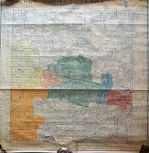
Jack County, Texas
Published by Fort Worth c.1950, Fort Worth, 1950
Seller: High Ridge Books, Inc. - ABAA, South Deerfield, MA, U.S.A.
Association Member: ABAA ESA ILAB SNEAB
Seller rating 5 out of 5 stars
Unbacked map of this county between Fort Worth and Wichita Falls. Good condition, several tears with light damage near the lower edge with no loss. Manuscript full color denotes school districts. Hundreds of large land owners identified. From the archives of the Rock Island Railroad.
-
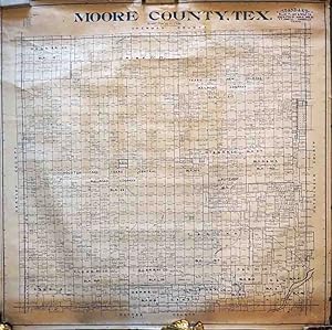
Moore County, Texas
Published by Fort Worth c.1950, Fort Worth, 1950
Seller: High Ridge Books, Inc. - ABAA, South Deerfield, MA, U.S.A.
Association Member: ABAA ESA ILAB SNEAB
Seller rating 5 out of 5 stars
Unbacked map of this county north of Amarillo in the Texas panhandle. Good condition, with some deterioration at edges. Land owners and drilling rights holders identified.The key at the top defines the symbols used for various oil drilling sites, whether producing, drilling, a dry hole or abandoned.
-
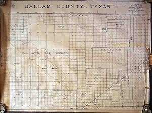
Dallam County, Texas
Published by Fort Worth c.1950, Fort Worth, 1950
Seller: High Ridge Books, Inc. - ABAA, South Deerfield, MA, U.S.A.
Association Member: ABAA ESA ILAB SNEAB
Seller rating 5 out of 5 stars
Unbacked map of this county at the northwest corner of the Texas panhandle. Some large land owners are identified as are some lands within the control of railroads. Two rail lines are highlighted with color. The key at the top left defines the symbols used for various oil drilling sites, whether producing, drilling, a dry hole or abandoned.
-
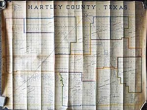
Hartley County, Texas
Published by Fort Worth c.1950, Fort Worth, 1950
Seller: High Ridge Books, Inc. - ABAA, South Deerfield, MA, U.S.A.
Association Member: ABAA ESA ILAB SNEAB
Seller rating 5 out of 5 stars
Unbacked map of this county at the west side of the Texas panhandle on the New Mexico border. Very good condition, one short tear at the bottom. Vertical creasing. Some areas have manuscript outline color. Land owners and drilling rights holders identified.The key at the top defines the symbols used for various oil drilling sites, whether producing, drilling, a dry hole or abandoned.
-
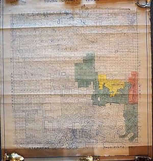
Young County, Texas
Published by Fort Worth c.1950, Fort Worth, 1950
Seller: High Ridge Books, Inc. - ABAA, South Deerfield, MA, U.S.A.
Association Member: ABAA ESA ILAB SNEAB
Seller rating 5 out of 5 stars
Unbacked map of this county west of Fort Worth and south of WIchita Falls. Good to very good condition, with some tears and deterioration at the top. Some areas have manuscript color. Land owners and drilling rights holders identified.The key at the top defines the symbols used for various oil drilling sites, whether producing, drilling, a dry hole or abandoned.
-
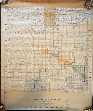
Baylor County, Texas
Published by Fort Worth c.1950, Fort Worth, 1950
Seller: High Ridge Books, Inc. - ABAA, South Deerfield, MA, U.S.A.
Association Member: ABAA ESA ILAB SNEAB
Seller rating 5 out of 5 stars
Unbacked map of this county in the northern Texas southwest of Wichita Falls. Hundreds of large land owners identified as are some lands within the control of railroads. Some manuscript color along rail lines. The key at the bottom defines the symbols used for various oil drilling sites, whether producing, drilling, a dry hole or abandoned.
-
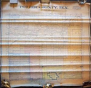
Potter County, Texas
Published by Fort Worth c.1950, Fort Worth, 1950
Seller: High Ridge Books, Inc. - ABAA, South Deerfield, MA, U.S.A.
Association Member: ABAA ESA ILAB SNEAB
Seller rating 5 out of 5 stars
Unbacked map of this county containing the city of Amarillo in the Texas panhandle. Good condition, with some tears and horizontal creasing. Some areas have manuscript color. Land owners and drilling rights holders identified.The key at the top defines the symbols used for various oil drilling sites, whether producing, drilling, a dry hole or abandoned.
-
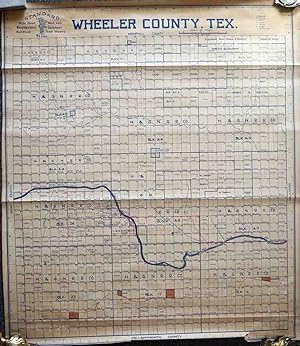
Wheeler County, Texas
Published by Fort Worth c.1950, Fort Worth, 1950
Seller: High Ridge Books, Inc. - ABAA, South Deerfield, MA, U.S.A.
Association Member: ABAA ESA ILAB SNEAB
Seller rating 5 out of 5 stars
Unbacked map of this county at the east side of the Texas panhandle between Amarillo and Oklahoma City. Very good condition, one short tear at the bottom. Some areas have manuscript color. Land owners holders identified.The key at the top defines the symbols used for various oil drilling sites, whether producing, drilling, a dry hole or abandoned.
-
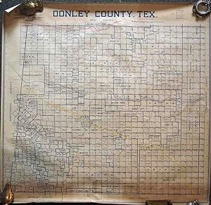
Donley County, Texas
Published by Fort Worth c.1950, Fort Worth, 1950
Seller: High Ridge Books, Inc. - ABAA, South Deerfield, MA, U.S.A.
Association Member: ABAA ESA ILAB SNEAB
Seller rating 5 out of 5 stars
Unbacked map of this county east of Amarillo in the northern Texas panhandle. Hundreds of large land owners identified. Two features are in color. The line of the Fort Worth and Denver Railroad is highlighted in yellow, and the C. O. & G. (Choctaw, Oklahoma & Gulf) line runs near the top of the map . The key at the top right defines the symbols used for various oil drilling sites, whether producing, drilling, a dry hole or abandoned.