
Order Total (1 Item Items):
Shipping Destination:

Society Diffusion Useful Knowledge Walker (26 results)
Feedback
Skip to main search results
Search filters
Product Type
- All Product Types
- Books (16)
- Magazines & Periodicals (No further results match this refinement)
- Comics (No further results match this refinement)
- Sheet Music (No further results match this refinement)
- Art, Prints & Posters (No further results match this refinement)
- Photographs (No further results match this refinement)
- Maps (10)
- Manuscripts & Paper Collectibles (No further results match this refinement)
Condition Learn more
- New (No further results match this refinement)
- As New, Fine or Near Fine (No further results match this refinement)
- Very Good or Good (5)
- Fair or Poor (No further results match this refinement)
- As Described (21)
Binding
- All Bindings
- Hardcover (No further results match this refinement)
- Softcover (No further results match this refinement)
Collectible Attributes
- First Edition (6)
- Signed (10)
- Dust Jacket (No further results match this refinement)
- Seller-Supplied Images (24)
- Not Print on Demand (26)
Language (2)
Price
- Any Price
- Under � 20 (No further results match this refinement)
- � 20 to � 35 (No further results match this refinement)
- Over � 35
Free Shipping
- Free Shipping to United Kingdom (No further results match this refinement)
Seller Location
Seller Rating
-

England IV. Cornwall, Devonshire, Somersetshire & Dorsetshire with small map of Scilly Islands. Antique Map. Landkarte von Cornwall, Devonshire, Somersetshire & Dorsetshire. Grenzkolorierter Original-Stahlstich von Walker bei Baldwin & Cradock 1830
Published by London: Baldwin & Cradock, 1830
Seller: historicArt Antiquariat & Kunsthandlung, Wiesbaden-Breckenheim, Germany
Seller rating 5 out of 5 stars

Map Signed
� 44.71
Convert currency� 10.42 shipping from Germany to United KingdomQuantity: 1 available
Add to basket1. Original-Stahlstich von J. & C. Walker (in der Platte signiert) auf r�ckseitig unbedrucktem Blatt, von alter Hand grenzkoloriert, bildliche Darstellung ca. 25,5 x 39 cm, Blattgr��e ca. 32 x 41 cm, unten im "English Channel" ein kleiner blasser Stockfleck, ansonsten sauber und sehr gut erhalten 2100 gr.
-

NO 6 - CIRCUMJACENT THE SOUTH POLE
Published by The Society For The Diffusion Of Useful Knowledge, LONDON, UK, 1842
Language: English
No Binding. Condition: Very Good. Sheet Size: 33cm x 33,.6cm. Original hand-colouring. Edition up to 1842 as Graham Land, Enderby Land, Sabrina land, La Terre Adele, Emerald Island and Balleny Island are shown. Ref: Tooley: 97. Short closed tears to upper and lower margins, not affecting the plate surface. Minor staining to bottom right hand corner. In very good condition overall. Scarce. Location: Map Drawer C: FS: Folder M2000 002552.
-

England III. Lincolnshire, Nottinghamshire, Derbyshire, Leicestershire, Warwickshire, Northhamptonshire, Huntingdonshire, Northfolk, Suffolk und Cambridgeshire. Antique Map. Grenzkolorierter Original-Stahlstich von Walker bei Baldwin & Cradock 1830
Published by London: Baldwin & Cradock, 1830
Seller: historicArt Antiquariat & Kunsthandlung, Wiesbaden-Breckenheim, Germany
Seller rating 5 out of 5 stars
Map First Edition Signed
� 53.65
Convert currency� 10.42 shipping from Germany to United KingdomQuantity: 1 available
Add to basket1. Original-Stahlstich von J. & C. Walker (in der Platte signiert) auf r�ckseitig unbedrucktem Blatt, von alter Hand grenzkoloriert, bildliche Darstellung ca. 27 x 36 cm, Blattgr��e ca. 35 x 41 cm, sauber und sehr gut erhalten 2100 gr.
-

England II. Anglesey, Cheshire, Staffordshire, Montgomeryshire, Shropshire, Pemborke, Cardiganshire, Glamorganshire und Gloucestershire. Antique Map. Grenzkolorierter Original-Stahlstich von Walker bei Baldwin & Cradock 1831
Published by London: Baldwin & Cradock, 1831
Seller: historicArt Antiquariat & Kunsthandlung, Wiesbaden-Breckenheim, Germany
Seller rating 5 out of 5 stars
Map First Edition Signed
� 53.65
Convert currency� 10.42 shipping from Germany to United KingdomQuantity: 1 available
Add to basket1. Original-Stahlstich von J. & C. Walker (in der Platte signiert) auf r�ckseitig unbedrucktem Blatt, von alter Hand grenzkoloriert, bildliche Darstellung ca. 31 x 37,5 cm, Blattgr��e ca. 34,5 x 41 cm, sauber und sehr gut erhalten 2100 gr.
-

Ancient Britain I. Antique Map. Landkarte von Gro�britannien in der Antike. Grenzkolorierter Original-Stahlstich von Walker bei Baldwin & Cradock 1834
Published by London: Baldwin & Cradock, 1834
Seller: historicArt Antiquariat & Kunsthandlung, Wiesbaden-Breckenheim, Germany
Seller rating 5 out of 5 stars
Map Signed
� 53.65
Convert currency� 10.42 shipping from Germany to United KingdomQuantity: 1 available
Add to basket1. Original-Stahlstich von J. & C. Walker (in der Platte signiert) auf r�ckseitig unbedrucktem Blatt mit dekorativ abgestztem Plattenrand, von alter Hand grenzkoloriert, bildliche Darstellung ca. 37 x 29 cm, Blattgr��e ca. 41 x 34 cm, im breiten Rand au�erhalb der bildlichen Darstellung leicht gegilbt, ansonsten sauber und sehr gut erhalten 2100 gr.
-

Ancient Britain II. Antique Map. Landkarte von Gro�britannien in der Antike. Grenzkolorierter Original-Stahlstich von Walker bei Baldwin & Cradock 1834
Published by London: Baldwin & Cradock, 1834
Seller: historicArt Antiquariat & Kunsthandlung, Wiesbaden-Breckenheim, Germany
Seller rating 5 out of 5 stars
Map Signed
� 53.65
Convert currency� 10.42 shipping from Germany to United KingdomQuantity: 1 available
Add to basket1. Original-Stahlstich von J. & C. Walker (in der Platte signiert) auf r�ckseitig unbedrucktem Blatt mit dekorativ abgestztem Plattenrand, von alter Hand grenzkoloriert, bildliche Darstellung ca. 34,5 x 28 cm, Blattgr��e ca. 40 x 34 cm, im breiten Rand au�erhalb der bildlichen Darstellung leicht gegilbt, ansonsten sauber und sehr gut erhalten 2100 gr.
-

Ancient Egypt. Published by the Society for the Diffusion of Useful Knowledge. Karte von �gypten in der Antike vom Nildelta bis zur Nilinsel Philae. Stahlstich von Walker 1831
Published by London: Baldwin & Cradock, 1831
Seller: historicArt Antiquariat & Kunsthandlung, Wiesbaden-Breckenheim, Germany
Seller rating 5 out of 5 stars
Map First Edition Signed
� 58.12
Convert currency� 10.42 shipping from Germany to United KingdomQuantity: 1 available
Add to basket1. Original-Stahlstich von Walker (in der Platte signiert) auf r�ckseitig unbedrucktem Blatt, bildliche Darstellung 36 x 30 cm, Blattgr��e ca. 41 x 34 cm, sehr gut erhalten 2100 gr.
-

Ancient. Africa or Libya. Part I. Karte von Libyen, Marokko und Tunesien in der Antike von Carthago bis zur W�ste Sahara. Grenz- und fl�chenkolorierter Stahlstich von Walker 1840
Published by London: Society for the Diffusion of Useful Knowledge, 1840
Seller: historicArt Antiquariat & Kunsthandlung, Wiesbaden-Breckenheim, Germany
Seller rating 5 out of 5 stars
Map First Edition Signed
� 58.12
Convert currency� 10.42 shipping from Germany to United KingdomQuantity: 1 available
Add to basket1. Original-Stahlstich von Walker (in der Platte signiert) auf r�ckseitig unbedrucktem Blatt, alt grenzkoloriert mit fl�chenkolorierten Seen, bildliche Darstellung 31 x 39,5 cm, Blattgr��e ca. 33,5 x 40,5 cm, sehr gut erhalten 2100 gr.
-

South America Sheet III Bolivia and Peru with a Part of Brazil
Published by Edward Stanford, London, 1857
Seller: Argosy Book Store, ABAA, ILAB, New York, NY, U.S.A.
Seller rating 5 out of 5 stars
� 38.17
Convert currency� 31.13 shipping from U.S.A. to United KingdomQuantity: 1 available
Add to basketunbound. Condition: very good. J. & C. Walker (illustrator). Map. Engraving with original hand coloring. Image measures 12" x 15.5". Detailed map of the eastern coast of South America. The Society for the Diffusion of Useful Knowledge was formed in 1826 and published low cost maps with the goal of reaching a large market, while still maintaining high quality and precision. Small tear to left margin.
-
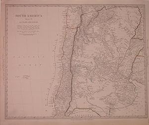
South America Sheet IV La Plata and Chile
Published by Charles Knight & Co, London, 1844
Seller: Argosy Book Store, ABAA, ILAB, New York, NY, U.S.A.
Seller rating 5 out of 5 stars
� 38.17
Convert currency� 31.13 shipping from U.S.A. to United KingdomQuantity: 2 available
Add to basketunbound. Condition: very good. J. & C. Walker (illustrator). Map. Engraving with original hand colored outline. Image measures 12.25" x 15.5". This map of the southern part of South America extends from the Bolivian border to Patagonia, depicting most of Argentina, and Chile, with parts of Uruguay, Paraguay, and Bolivia. Incredibly detailed, the map notes rivers, cities, towns, major routes, mountain passes, lagunas, and topographical descriptions. Elevation is rendered by hachure. Major expeditions are labeled with dates and descriptions, and principal cities show population. This map is in excellent condition. The Society for the Diffusion of Useful Knowledge was formed in 1826 and published low cost maps with the goal of reaching a large market, while still maintaining high quality and precision.
-
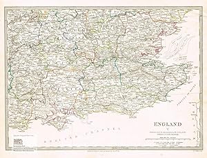
England V. Oxfordshire, Buckinghamshire, Hertfordshire, Essex, Middlesex, Berkshire, Wiltshire, Hampshire, Surrey, Kent, Sussex, Isle of Wight, London. Antique Map. Grenzkolorierter Original-Stahlstich von Walker bei Baldwin & Cradock 1830
Published by London: Baldwin & Cradock, 1830
Seller: historicArt Antiquariat & Kunsthandlung, Wiesbaden-Breckenheim, Germany
Seller rating 5 out of 5 stars
Map First Edition Signed
� 62.59
Convert currency� 10.42 shipping from Germany to United KingdomQuantity: 1 available
Add to basket1. Original-Stahlstich von J. & C. Walker (in der Platte signiert) auf r�ckseitig unbedrucktem Blatt, von alter Hand grenzkoloriert, bildliche Darstellung ca. 27 x 37,5 cm, Blattgr��e ca. 34,5 x 41 cm, sauber und sehr gut erhalten 2100 gr.
-

Ancient Egypt. Published by the Society for the Diffusion of Useful Knowledge. Karte von �gypten in der Antike vom Nildelta bis zur Nordgrenze von �thopien. Altkolorierter Stahlstich von J. und C. Walker 1831
Published by London: Baldwin & Cradock, 1831
Seller: historicArt Antiquariat & Kunsthandlung, Wiesbaden-Breckenheim, Germany
Seller rating 5 out of 5 stars
Map First Edition Signed
� 62.59
Convert currency� 10.42 shipping from Germany to United KingdomQuantity: 1 available
Add to basket1. Original-Stahlstich von Walker (in der Platte signiert) auf r�ckseitig unbedrucktem Blatt, bildliche Darstellung 36,5 x 30 cm, Blattgr��e ca. 40,5 x 33,5 cm, von alter Hand entlang des Nillaufs und der K�sten zum Mittelmeer und zum Arabischen Golf koloriert, sauber und sehr gut erhalten 2100 gr.
-

Scotland III. Orkneys, Shetlands and Hebrides. Antique Map. Landkarte von Orkney, den Shetland Inseln und den Hebriden. Grenzkolorierter Original-Stahlstich von Walker bei Baldwin & Cradock 1834
Published by London: Baldwin & Cradock, 1834
Seller: historicArt Antiquariat & Kunsthandlung, Wiesbaden-Breckenheim, Germany
Seller rating 5 out of 5 stars
Map Signed
� 107.30
Convert currency� 10.42 shipping from Germany to United KingdomQuantity: 1 available
Add to basket1. Original-Stahlstich von J. & C. Walker (in der Platte signiert) auf r�ckseitig unbedrucktem Blatt, von alter Hand grenzkoloriert, bildliche Darstellung ca. 38 x 31 cm, Blattgr��e ca. 41 x 34 cm, sauber und sehr gut erhalten 2100 gr.
-

North America: Sheet IV Lake Superior
Published by Baldwin & Gradock, London, 1844
Seller: Argosy Book Store, ABAA, ILAB, New York, NY, U.S.A.
Seller rating 5 out of 5 stars
� 95.42
Convert currency� 31.13 shipping from U.S.A. to United KingdomQuantity: 1 available
Add to basketunbound. J. & C. Walker (illustrator). Map. Lithograph with hand coloring. Measures 16" x 13.5". This map centers on Lake Superior, with Ontario, Canada to the north and Michigan to the south. Delicate pink and green hand-coloring denotates the US/Canada border. The Algonquin and Chippeway tribes are labeled in modern-day northern Michigan, and northern Lake Michigan is visible in the lower margin. Lakes, rivers, islands, and other topographical features are labeled with great detail, including notes on navigability and direction. In very good condition, small tape residue on margins that do not affect the image.
-

Portugal
Published by Charles Knight & Co, London, 1843
Seller: Argosy Book Store, ABAA, ILAB, New York, NY, U.S.A.
Seller rating 5 out of 5 stars
� 95.42
Convert currency� 31.13 shipping from U.S.A. to United KingdomQuantity: 1 available
Add to basketunbound. Condition: very good. J. & C. Walker (illustrator). Map. Steel engraving with original color outline. Image measures 13.75" x 9.5". Classic map of Portugal showing geographical features and major routes. Minor aging along edges. The Society for the Diffusion of Useful Knowledge was formed in 1826 and published low cost maps with the goal of reaching a large market, while still maintaining high quality and precision.
-
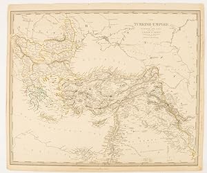
The Turkish Empire in Europe and Asia with the Kingdom of Greece.
Published by Charles Knight & Co. [circa1840s.], London., 1840
Seller: Asia Bookroom ANZAAB/ILAB, Canberra, ACT, Australia
Association Member: ANZAAB ILAB
Seller rating 5 out of 5 stars
� 112.58
Convert currency� 16.68 shipping from Australia to United KingdomQuantity: 1 available
Add to basketLithographed map with original outline hand-colour, 31.9 x 39.1 cm, small marginal tears neatly repaired with archival material, but no loss, small surface abrasion affecting the border at the foot, edgewear and browning, inked pagination in an early hand, but in very good condition. A handsome map with fine topographical engraving, also showing the borders with Hungary, Russia and Persia.
-

Calcutta
Published by Charles Knight, London
Seller: Argosy Book Store, ABAA, ILAB, New York, NY, U.S.A.
Seller rating 5 out of 5 stars
� 125.95
Convert currency� 31.13 shipping from U.S.A. to United KingdomQuantity: 1 available
Add to basketunbound. J. & C. Walker (illustrator). Map. Engraving. Sheet measures 13" x 16" This map by the The Society for the Diffusion of Useful Knowledge shows the city of Calcutta in incredibly detail. Streets and buildings are meticulously rendered, with public buildings, churches, and chapels labeled. Three illustrations are included, depicting Writers Buildings, Government House, and Esplanade Row. The map is in very good condition. Published by Charles Knight for the SDUK circa 1844. The Society for the Diffusion of Useful Knowledge was formed in 1826 and published low cost maps with the goal of reaching a large market, while still maintaining high quality and precision.
-
Calcutta
Published by Charles Knight, London
Seller: Argosy Book Store, ABAA, ILAB, New York, NY, U.S.A.
Seller rating 5 out of 5 stars
� 125.95
Convert currency� 31.13 shipping from U.S.A. to United KingdomQuantity: 1 available
Add to basketunbound. J. & C. Walker (illustrator). Map. Engraving with original hand coloring. Sheet measures 13" x 16" This map by the The Society for the Diffusion of Useful Knowledge shows the city of Calcutta in incredibly detail. Streets and buildings are meticulously rendered, with public buildings, churches, and chapels labeled. Three illustrations are included, depicting Writers Buildings, Government House, and Esplanade Row. The map is in very good condition. Published by Charles Knight for the SDUK circa 1844. The Society for the Diffusion of Useful Knowledge was formed in 1826 and published low cost maps with the goal of reaching a large market, while still maintaining high quality and precision.
-

North America Sheet XII. Georgia with Parts of North & South Carolina, Tennessee, Alabama & Florida
Published by Baldwin & Cradock, London, 1846
Seller: Argosy Book Store, ABAA, ILAB, New York, NY, U.S.A.
Seller rating 5 out of 5 stars
� 152.67
Convert currency� 31.13 shipping from U.S.A. to United KingdomQuantity: 1 available
Add to basketunbound. J. & C. Walker (illustrator). Map. Hand colored engraving. Image measures 15 3/8" x 12". Nicely detailed map of Georgia with parts of surrounding states. Delineates counties, major cities and waterways. Topography is beautifully rendered by hachure. Interestingly, this map shows territories occupied by the Cherokee and Creek Indians, despite their forced removal several years before the publication date. Native American villages are depicted with a tee-pee symbol, settler towns with a circle, and forts with a star-like symbol. Many villages are labeled, including Etowah, a prehistoric site established around 1000 A.D. and inhabited by the Cherokee from the late 18th century. New Echota is also labeled, and was the capital of the Cherokee Nation until their forced removal in 1838. The Society for the Diffusion of Useful Knowledge was formed in 1826 and published low cost maps with the goal of reaching a large market, while still maintaining high quality and precision.
-
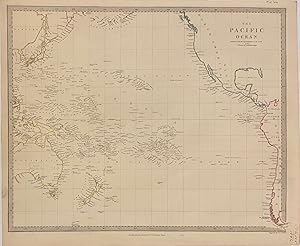
The Pacific Ocean
Published by Charles Knight & Co, London, 1846
Seller: Argosy Book Store, ABAA, ILAB, New York, NY, U.S.A.
Seller rating 5 out of 5 stars
� 152.67
Convert currency� 31.13 shipping from U.S.A. to United KingdomQuantity: 1 available
Add to basketunbound. J. & C. Walker (illustrator). Map. Engraving. Image measures 12 1/2" x 15 1/2" This highly detailed map by the Society for the Diffusion of Useful Knowledge, or SDUK, depicts the Pacific Ocean. Island groups and coastlines are extensively labeled, while the interiors are relatively unmapped. Some Pacific islands are labeled with question marks, indicating uncertainty of their existence. The map is in excellent condition. The Society for the Diffusion of Useful Knowledge was formed in 1826 and published low cost maps with the goal of reaching a large market, while still maintaining high quality and precision.
-
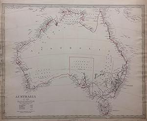
Australia in 1839; 1840 SDUK Map of Australia with unexplored interiors
Published by Chapman and Hall, London, 1840
Seller: Argosy Book Store, ABAA, ILAB, New York, NY, U.S.A.
Seller rating 5 out of 5 stars
� 171.76
Convert currency� 31.13 shipping from U.S.A. to United KingdomQuantity: 1 available
Add to basketunbound. Condition: very good. J. & C. Walker (illustrator). Map. Engraving. Sheet measures 16" x 13.5". Some light foxing and staining. In very good condition. This detailed map by the Society for the Diffusion of Useful Knowledge or SDUK depicts the entire continent of Australia in 1839, including Van Diemen's Land or Tasmania. Incredibly detailed along the coastlines, the interiors are relatively unmapped, reflecting the lack of knowledge of the region. The colony of South Australia, which was established in 1834 is the only colony showing a border, though other colonies are identified along with dates of establishment. Several notations also identify the names of explorers who discovered these lands along with the dates of discoveries. Copyrighted in 1840 and published by Chapman and Hall for the SDUK's. The map is in good condition with minor foxing and minor edge wear. The Society for the Diffusion of Useful Knowledge was formed in 1826 and published low cost maps with the goal of reaching a large market, while still maintaining high quality and precision.
-
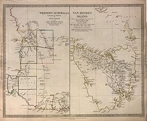
Western Australia Containing the Settlements of Swan River and King George's Sound. Van-Diemen Island.; 1844 SDUK map of Western Australia and Tasmania post the Black War
Published by Baldwin & Cradock, London, 1844
Seller: Argosy Book Store, ABAA, ILAB, New York, NY, U.S.A.
Seller rating 5 out of 5 stars
� 171.76
Convert currency� 31.13 shipping from U.S.A. to United KingdomQuantity: 2 available
Add to basketunbound. J. & C. Walker (illustrator). Map. Engraving with original hand outline coloring. Sheet measures 13.5" x 16". This lovely 1844 map by the Society for the Diffusion of Useful Knowledge or SDUK depicts Western Australia and Tasmania or Van Diemen's Island. Issued as two separate maps printed on a single sheet, the map of the left details the southwest portions of Western Australia extending from Albany to Jurien Bay. Notes settlements, including those of Swan River and King George's Sound, as well as rivers, mountains and other topographical features. The map on the right details Tasmania and includes significant updates from previous editions, reflecting the further exploration of the region and is issued just a few years following the Black War which all but annihilated the islands indigenous people. Copyrighted in 1833 and published by Baldwin and Cradock for the SDUK. The map is in good condition with minor foxing and minor edge wear. The Society for the Diffusion of Useful Knowledge was formed in 1826 and published low cost maps with the goal of reaching a large market, while still maintaining high quality and precision.
-

North America Sheet XII. Georgia with Parts of North & South Carolina, Tennessee, Alabama & Florida
Published by Baldwin & Cradock, London, 1846
Seller: Argosy Book Store, ABAA, ILAB, New York, NY, U.S.A.
Seller rating 5 out of 5 stars
� 190.84
Convert currency� 31.13 shipping from U.S.A. to United KingdomQuantity: 1 available
Add to basketunbound. J. & C. Walker (illustrator). Map. Hand colored engraving. Image measures 15 3/8" x 12". Nicely detailed map of Georgia with parts of surrounding states. Delineates counties, major cities and waterways. Topography is beautifully rendered by hachure. Interestingly, this map shows territories occupied by the Cherokee and Creek Indians, despite their forced removal several years before the publication date. Native American villages are depicted with a tee-pee symbol, settler towns with a circle, and forts with a star-like symbol. Many villages are labeled, including Etowah, a prehistoric site established around 1000 A.D. and inhabited by the Cherokee from the late 18th century. New Echota is also labeled, and was the capital of the Cherokee Nation until their forced removal in 1938. The Society for the Diffusion of Useful Knowledge was formed in 1826 and published low cost maps with the goal of reaching a large market, while still maintaining high quality and precision.
-

North America Sheet V The North West and Michigan Territories
Published by Baldwin and Cradock, London, 1844
Seller: Argosy Book Store, ABAA, ILAB, New York, NY, U.S.A.
Seller rating 5 out of 5 stars
� 209.92
Convert currency� 31.13 shipping from U.S.A. to United KingdomQuantity: 1 available
Add to basketunbound. J. & C. Walker (illustrator). Map. Uncolored engraving. Sheet measures 13" x 16". Nice clean map of Wisconsin and Michigan, detailing Lake Michigan, the second largest of the Great Lakes. Notes the Huron and Northwest Territories in modern day Wisconsin, the Michigan Territory and the northern part of Illinois. Notes an elongated depiction of Lake Michigan. Labels various Indian tribes and topography. The map notes the Bad Axe River, the site for the Bad Axe Massacre or the Battle of Bad Axe fought in 1832, just a year prior to the publishing of this map. Map is in good condition with minor toning at edges. The Society for the Diffusion of Useful Knowledge was formed in 1826 and published low cost maps with the goal of reaching a large market, while still maintaining high quality and precision.
-
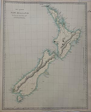
The Islands of New Zealand
Published by Chapman and Hall, London, 1844
Seller: Argosy Book Store, ABAA, ILAB, New York, NY, U.S.A.
Seller rating 5 out of 5 stars
� 209.92
Convert currency� 31.13 shipping from U.S.A. to United KingdomQuantity: 1 available
Add to basketunbound. J. & C. Walker (illustrator). Map. Engraving. Sheet measures 16" x 13.5". Some light foxing and staining. In very good condition. This detailed map by the Society for the Diffusion of Useful Knowledge or SDUK depicts New Zealand. Incredibly detailed along the coastlines, the interiors are relatively unmapped, reflecting the lack of knowledge of the region. Features interesting notes such as High mountains said to be covered with perpetual snow, Supposed coal fields, and Lookers on appearance of a fine harbour. The map is in good condition with minor foxing and minor edge wear. The Society for the Diffusion of Useful Knowledge was formed in 1826 and published low cost maps with the goal of reaching a large market, while still maintaining high quality and precision.
-

North America
Published by Chapman and Hall, London, 1843
Seller: Argosy Book Store, ABAA, ILAB, New York, NY, U.S.A.
Seller rating 5 out of 5 stars
� 229.01
Convert currency� 31.13 shipping from U.S.A. to United KingdomQuantity: 1 available
Add to basketunbound. Walker, J. & C. (illustrator). Map. Engraving with hand coloring. Sheet measures 16" x 13 1/8". This mid 19th century map of North America features the Republic of Texas the year prior to its annexation in 1845. Shows the entirety of the United States, Canada ("British America" on the map), Mexico, and Central America until "Nueva Granada" which is now Colombia. Published by Chapman and Hall for the S.D.U.K. Engraved by J. & C. Walker. The map is in good condition. The Society for the Diffusion of Useful Knowledge was formed in 1826 and published low cost maps with the goal of reaching a large market, while still maintaining high quality and precision.
