Order Total (1 Item Items):
Shipping Destination:

Seutter Matthaus (583 results)
Skip to main search results
Search filters
Product Type
- All Product Types
- Books (217)
- Magazines & Periodicals (No further results match this refinement)
- Comics (No further results match this refinement)
- Sheet Music (No further results match this refinement)
- Art, Prints & Posters (81)
- Photographs (No further results match this refinement)
- Maps (284)
- Manuscripts & Paper Collectibles (1)
Condition Learn more
Binding
Collectible Attributes
Language (6)
Free Shipping
Seller Location
Seller Rating
-

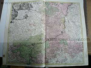
Grundri� und Ansicht der Stadt Danzig. Nachdr. des Orig. nach 1730
Published by Pfaehler, Bad Neustadt, 1986
Seller: Margret Hamann Versandantiquariat, Hamburg, Germany
Seller rating 5 out of 5 stars

1 Karte plano 56 x 48 cm gutes Exemplar.
-
[Map] "Diversi Globi Terr-Aquei Statione Variante et Visu Intercedente, Per Coluros Tropicorum Per Ambos Polos et Particul, Sphaerae Zenith in Planum Deleati Orthographici Prospectus" from Atlas Minor?
Published by Georg Matthaus Seutter, Augsburg, 1744
Language: English
Seller: Lloyd Zimmer, Books and Maps, Chanute, KS, U.S.A.
Seller rating 5 out of 5 stars
Map
Soft cover. Condition: Very Good. No Jacket. Highly decorative map of the hemispheres. Steel engraving with hand coloring. 10 � x 8 inches, on slightly larger leaf. California is shown as an Island. Strong impression on hand laid paper with water-mark. Top edge trimmed close to border. Smudges and some darkening near edges and lightly scattered through image. Good, contemporary coloring.
-
Liege-Maastricht-Brusselles, anno 1740, map by Seutter Matth�us
Published by Seutter Matth�us, 1678 - 1757, 1757
Hardcover. Condition: very good. Liege-Maastricht-Brusselles, anno 1740, map by Seutter Matth�us SEUTTER, G.M. - L'Eveche et L'Etat de Liege Avec les appartenances design�es dans les pais voisins Delineation nouvelle et exacte Aux depens de Matthieu Seutter. Augsburg, 1740. 49 x 61 cm. Contemporary colours Beautiful cooper engraved map of the central part of Belgium and parts of the Netherlands by M. Seutter. Showing the area around Li�ge and Maastricht. The nice cartouche with two Belgium Lions. Printed on thick paper, only little stained, with a small restoration on left margin. Please look the pictures.
-
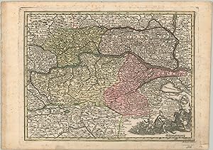
Archiducatus Austriae Inferioris - The political center of the Hapsburg Monarchy.
Published by c. 1744, 1744
Seller: Curtis Wright Maps, Berwyn, IL, U.S.A.
Seller rating 5 out of 5 stars
Condition: Very Good. This mid-18th century map was engraved by Tobias Conrad Lotter and published in Augsburg by Matthaus Seutter around 1744. It presents a detailed overview of the Archduchy of Austria, an important component of the Holy Roman Empire centered on the capital at Vienna. The River Danube bisects the image from right to left and topography is depicted pictorially. An interesting variety of place names are labeled, including fortified outposts, monasteries, market towns, hunting lodges, and much more. The lower right presents a decorative title cartouche with a coat of arms and a scene from a military engagement. At the time of publication, Maria Theresa of Austria was struggling to claim her inheritance as ruler of the Hapsburg monarchy from her father, the Holy Roman Emperor Charles VI. The ongoing War of Austrian Succession would eventually be settled in 1748, resulting in the Diplomatic Revolution and a changed political scene that would set the scene for the outbreak of the Seven Years' War. Sheet Width (in) 12 Sheet Height (in) 8.5 Condition Description Moderate spotting visible in the margins and a few places within the image. Very good overall, with original color.
-
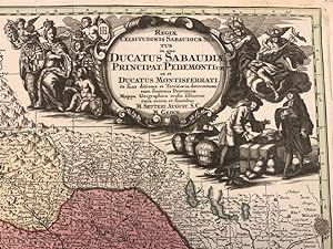
"Ducatus Sabaudiae Princip. Pedemontium ut et Ducatus Montisferrati." - Savoia Piemonte Savoy Savoie Liguria Italia Piemont Italy map Karte
Published by Augsburg ca. 1745., 1745
Language: Latin
Seller: Antiquariat Steffen V�lkel GmbH, Seubersdorf, Germany
Seller rating 5 out of 5 stars
Art / Print / Poster
Seltene altkolorierte Kupferstich-Karte von ca. 1745. -- Blatt-Ma�e: ca. 31,5 x 21,5 cm. -- gut erhalten. || Original old colored copper engraved map from c. 1745. -- in good condition. // Wir, das Antiquariat Steffen V�lkel, kaufen und verkaufen alte B�cher, Handschriften, Zeichnungen, Autographen, Grafiken und Fotografien. Wir sind stets am Ankauf von kompletten Bibliotheken, Sammlungen und Nachl�ssen interessiert. la Gewicht in Gramm: 1550.
-
Germaniae Inferioris sive Belgii Pars Meridionalis exhibens X. Provincias Catholic
Published by Seutter, M., Augsburg, 1744
Seller: Antikvariat Krenek, Prag, Czech Republic
Association Member: ILAB
Seller rating 5 out of 5 stars
Belgium and Luxembourg. "Germaniae Inferioris sive Belgii Pars Meridionalis exhibens X. Provincias Catholic". Altkol. Kupf.-Kte. von M. Seutter, 1744. Mit 2 fig. und ornament. Kart. 19,5:25,5 cm. A miniature map of Belgium and Luxembourg.
-
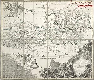
"Anhaltinus Principatus Stirpis Ascaniensis felicitate hodie florens geographico penicillo descriptus � Matthaeo Seuttero Geogr. Caesar. Aug. Vindel. Cum Privil. S. Reg. Pol. et Elect. Saxon".
Published by Augsburg, Seutter, um 1730., 1730
Seller: Antiquariat MEINDL & SULZMANN OG, Wien - Vienna, Austria
Seller rating 5 out of 5 stars
4�. In 8 Segmenten auf Leinen aufgezogen und faltbar eingerichtet (ca. 49 x 58 cm). Zeigt das Gebiet Magdeburg, Wittenberg, Halle, Blankenburg, Quedlinburg. Sehr detaillierte Karte mit Einzeichnung der Berge des Unterharzes. Mit 3 sch�nen Rokokokartuschen (darunter eine Wappenkartusche). In der linken unteren Ecke der "Meilen Zeiger der Staedte Flecken und Aembter des F�rsten-Thums Anhalt, nebst etlichen angraenzenden �rtern".- Linke untere Ecke mit kleiner L�sur. Die Leinenr�ckseite angestaubt und stellenweise etw braunleckig. Das Kartenbild in nahezu fleckenfreiem Erhaltungszustand.
-
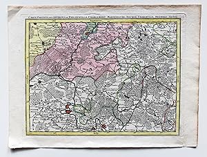
Carte Particul. Des Environs De Philippeville, Charlemont, Marienbourg, Rocroy, Charleville, Mezieres, Sedan. Kupferstichkarte ca. 1:300000.
Published by o.J. um 1750, Augsburg, 1750
Map
Condition: Gut. Teilkolorierte Karte Blatt 23 des24 Blatt umfassenden Monumentalwerks "Les provinces des Pays Bas Autrichiens contenants en XXIV feuilles les comt�es d'Artois, de Flandres, de Hainaut, de Namur et les duch�es de Luxembourg, de Limbourg, de Gueldre et de Brabant, divis�es dans ses baillages, ch�tellanies, quartiers ou seigneuries, avec une partie de la France, d'Angleterre et du Canal" (�sterr. Niederlande). Augsburger Kopie des Belgischen Originals von Matth�us Seutter. Karte lediglich mit Titelzeile und Nummer 23 im rechten unteren Eck, ohne Ma�stab oder Verfasserinformationen. Karte in gutem Zustand mit leichten Alters- / Gebrauchsspuren. Sprache / Language: fr 1 Seiten. ca. 23,5 x 31,5 cm.
-

Stiria Ducatus
Published by Augsburg, 1730
Seller: Antikvariat Krenek, Prag, Czech Republic
Association Member: ILAB
Seller rating 5 out of 5 stars
Steiermark. "Stiria Ducatus". Altkol. Kupf.-Kte. bei M. Seutter, um 1730. Mit gr. fig. titelkart. mit Wappen u. fig. kart. mit Meilanzeiger u. Erkl�rungen. 49,5:57 cm. Zeigt Steiermark.
-

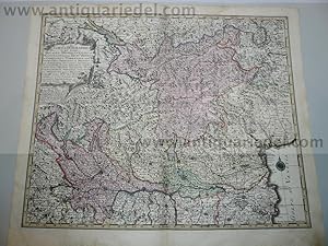
Circulus Suevicus in quo Ducatus Wirtenbergensis cum reliquis Statibus et Provinciis curate designatus proponitur
Published by Seutter, Mathias, Augsburg, 1730
Seller: Antikvariat Krenek, Prag, Czech Republic
Association Member: ILAB
Seller rating 5 out of 5 stars
W�rttemberg and Swabia. "Circulus Suevicus in quo Ducatus Wirtenbergensis cum reliquis Statibus et Provinciis curate designatus proponitur". Altkol. Kupf.-Kte. von M. Seutter, Augsburg, um 1730. Mit fig. Titelkart. und ornament. Kart. mit Legende und Meilanzeiger. 50:57,5 cm. Karte von W�rttemberg und den heutigen bayrischen Regierungsbezirk Schwaben (das Gebiet zwischen Bad Wimpfen u. Heilbronn i.N. und Bodensee m. Umgebung i.S. Mittig Stuttgart, Esslingen, T�bingen, Reutlingen).
-
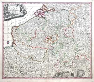
Germaniae inferioris sive Belgii pars meridionalis
Published by Seutter, M., Augsburg, 1730
Seller: Antikvariat Krenek, Prag, Czech Republic
Association Member: ILAB
Seller rating 5 out of 5 stars
Belgium, Luxembourg. "Germaniae inferioris sive Belgii pars meridionalis". Altkol. Kupf.-Kte. von M. Seutter, (um 1730). Mit 2 fig. Kart. u. kl. Plan von Ostende. 49,5:57,5 cm. Eine von sp�teren Ausg. mit Gradnetz u. Findbuchstaben.
-
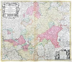
Mappa Circuli Rhenani Superioris
Published by Seutter, Matthias, Augsburg, 1740
Seller: Antikvariat Krenek, Prag, Czech Republic
Association Member: ILAB
Seller rating 5 out of 5 stars
Hessen. "Mappa Circuli Rhenani Superioris". Altkol. Kupf.-Kte., M. Seutter, um 1740. Mit gr. herald. Titelkart. (mit 21 Wappen) und fig. Kart. mit Meilenanzeiger und Erkl�rungen. 50:58 cm. Karte von Gesamt-Hessen mit der Einteilung in Grafschaften, F�stent�rmer und Herrschaften.
-

Brabantiae Ducatus, anno 1740, Seutter M. contemporary colours
Published by Seutter Matth�us, 1678 - 1757, 1757
Hardcover. Condition: Gut. Brabantiae Ducatus, anno 1740, Seutter M. contemporary colours Brabantiae Ducatus Cum Adjacentibus Provinciis studio et impensis Matthaei Seutteri, S. Caes. et Reg. Cathol. Majest. Geographi, Augustae Vindel. Size of the leaf: 53x60 cm., printed on thick paper in publishers colours, clean print, one small restoration on centerfold, not to see in front of the map.
-

Paris with environs, streetmap, 1740, Seutter Matth�us
Published by Seutter Matth�us, 1678 - 1757, 1757
Hardcover. Condition: very good. Paris with environs, streetmap, 1740, Seutter Matth�us Carte de la Prevoste et Vicomte de Paris - DreBee fur ungrand nombre de Memoires particudiers aBujettis aux Observations de Mrs. d l Academie Rle des Sciences; Gravee par Matth. Seutter, S. C. et R. Cath. M. Geogr. a Augsbourg. Augsburg, Matthaeus Seutter 1740 - size of the leaf: 53x62 cm. Copper-engraving, handcolored in outline and wash , IN PUBLISHERS COLOURS. Decorative map by the famous cartographer Matthaeus Seutter showing the nearer district around Paris. Showing small place names, villages, casles, monastries, rivers, lakes, streets, etc. THE MAP IS IN EXCELLENT CONDITION, PRINTED ON THICK PAPER, NO CRACS.
-

Les Routes Exactes des Postes du Royaume de France - Matth�us Se
Published by Seutter Matth�us, 1678 - 1757, 1757
Hardcover. Condition: very good. Les Routes Exactes des Postes du Royaume de France - Matth�us Seutter ca 1740 Altkolorierter Kupferstich, Blatt: 61 x 54 cm, Darstellung: 57 x 45 cm. Dekorative altkolorierte Postkarte von Frankreich mit franz�sischem Titel und Legende im Rand. Sehr sch�nes Altkolorit, gedruckt auf festem Papier. Hinterlegter Einriss, fachm�nnisch restauriert.
-
Condition: -. 49 x 59 cm. altkolorierter Kupferstich auf Leinen aufgezogen m. Faltspuren.
-

Condition: Buono (Good). La carta � uno dei rifaciamenti della tavola "Tabula Ducatus Carniola, Vindorum Marchiae et Histriae" di Johann Baptiste Homann realizzata dopo il 1716. acquaforte acquerellata in epoca cm. 58 x 49.5 Buono (Good) Buon es. - piccoli strappi nel margine superiore. Book.
-
Condition: Buono (Good). In: Atlas novus indicibus instructus, oder mit Wort-Registern versehener Atlas. BI42, Gedr. Bej J.P. v. Ghelen Wien 1730. La nostra versione � uguale con il ridisegnato il cartiglio e sovrapposto il reticolo delle coordinateSi differenzia da quella di J.B. Homann del 1716 solamente per la composizione del cartiglio di destra, variato negli atteggiamenti delle figurte umane e allegoriche.Scheda bibliografica tratta da Il territorio trentino-tirolese nell'antica cartografia,� Gino Tomasi, p. 165, scheda 56. 1 54.5x65.5 cm Buono (Good) Segni d'uso e del tempo con gore marginali fronte e retro. Book.
-

Asia,Generalmap,Seutter-Lotter,anno 1750,old colours
Published by Seutter Matth�us, 1678 - 1757, 1757
Hardcover. Condition: Gut. Copperengraving, edited by Seutter-Lotter, Augsburg, approx. anno 1750, full contemporary colours, little brownish, size of the leaf: 21 x 28 cm.
-
Hardcover. Condition: Gut. Coppermap, edited by Seutter Matth�us, anno 1730, size of the leaf: 53 x 62 cm., printed on thick paper, little brownish on margins. Small restauration on verso, in front not to see.
-

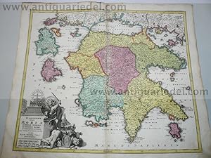
Graeciae pars Meridionalis, 1740, Seutter M., old colours; ed
Published by Seutter Matth�us, 1678 - 1757, 1757
Hardcover. Condition: Gut. Graeciae pars Meridionalis, 1740, Seutter M., old colours; edited by Matth�us Seutter, Augsburg. Comtemporary publishers colours, printed on thick paper, very good condition. Size of the leaf: 52x63 cm.
-
Regiae Celsitudinis Sabaudicae status in quo Ducatus Sabaudiae Principat Pedemontium et Ducatus Montisferrati.
Published by (Augsburg), sine data (1730 circa),, 1730
Seller: Libreria Antiquaria Pregliasco, Torino, TO, Italy
Seller rating 5 out of 5 stars
Condition: molto buono. Incisione in rame mm 500 x 570 arricchita da bella coloritura coeva. Titolo inciso entro grande ed elaborato cartiglio in bianco nero, raffigurante una scena mercantile, posto nella porzione superiore destra del rame. Nell'angolo in basso a destra sono riportate le scale grafiche "Milliaria Germanica communia 15 in uno gradu" e "Miliaria Italica communia". La carta ripropone, modificandone il cartiglio, quella di J.B. Homann, del quale Seutter era stato collaboratore. Matthia Seutter di Augsburg (1678-1757) fu allievo di Homann e ne continu� l'attivit� come cartografo, incisore ed editore di atlanti. Carta geografica dei territori del Piemonte e della Savoia Bell'esemplare con qualche piccolo strappetto abilmente restaurato nel margine superiore bianco. G. Aliprandi, Le grandi Alpi ( 2005), p. 288 (v. 1); F. Barrera, Il Piemonte nella cartografia del Settecento, n. 30 ; Torino e il suo orizzonte, n. 107 e n. 123. Book.
-
Scotia, anno 1740, map, Seutter M., original colours
Published by Seutter Matth�us, 1678 - 1757, 1757
Hardcover. Condition: Gut. Scotia, anno 1740, map, Seutter M., original colours SEUTTER,M. - Nova et accurata totius Regni Scotiae, Secundum Omnes Provincias et adjacentes Insulas., published in Augsburg 1740. Published : Augsburg 1740. Size: 57 x 49 cm. Very fine, original publishers colours, printed on thick paper, fine print. Fully and strongly engraved copper plate map that includes all of Scotland and the New Hebrides, here called the Western Iles of Scotland. The map is filled with minute detail and hundreds of place names. Embellished with two large and most decorative cartouches with figures, coat of arms, and a compass rose off the mouth of the Fyrth of Forth.
-

Hardcover. Condition: Gut. Italy Generalmap, Seutter Matth�us, a. 1720 Generalmap, edited by Matth�us Seutter, anno 1720, contemporary coloured, Size of the leaf: 53 x 62 cm., printed on thick paper, on upper margin little waterstained, not to see. very scarce map of Italy.
-

Nordeuropa, Schweden, Ostsee, anno 1740, Seutter M., altkolorier
Published by Seutter Matth�us, 1678 - 1757, 1757
Hardcover. Condition: very good. Nordeuropa, Schweden, Ostsee, anno 1740, Seutter M., altkoloriert Nova mappa geographica Sueciae ac Gothiae Regna ut et Finlandiae Ducatum ac Lapponiam, cum provinciis minoribus Seutter, Mathias, 1740 "Nova mappa geographica Sueciae ac Gothiae Regna ut et Finlandiae Ducatum ac Lapponiam, cum provinciis minoribus". Altkol. Kupf.-Kte. von M. Seutter, um 1740. Mit fig. u. herald. Kart. 49,5:57,5 cm., Blatt: 53x62 cm., gedruckt auf festem Papier, sehr sch�nes zeitgen�ssisches Kolorit, etwas fingerfleckig, an den R�ndern von hinten verst�rkt.
-

NOVA ET EXACTISSIMA TOTIUS ITALIAE SARDINIAE ET CORSICAE DELINEATIO OPERA ET IMPENSIS
Published by Augusta, 1730 ca., Augusta, 1730
Condition: Buono (Good). acquaforte acquerellata a mano inciso cm. 57 x 48 - foglio cm. 60,5 x 52,6 Buono (Good) Buon es. Book.
-
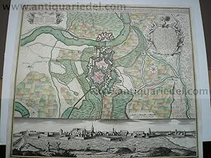
Hardcover. Condition: Gut. Philippsburg, anno 1730, Seutter Matth�us, Blattma�: 51x60 cm.
-
Mediolanensis,Venetia,map,Seutter anno 1720,old coloured
Published by Seutter Matth�us, 1678 - 1757, 1757
Hardcover. Condition: Gut. Original coppermap, edited by Matth�us Seutter, anno 1720, printed on thick paper, contemporary full coloured, very good condition, no cracs or tears, centerfold ok., little brownish on margins. To see northern Italy with the italian lakes and Venetia. Below margins: Parma, Modena, Bologna.
-
Hardcover. Condition: Gut. Morea,Peloponnes,map, Seutter,anno 1730 Coppermap, edited by Matth�us Seutter, anno 1730, size of the leaf 53 x 62 cm., nice, contemporary coloured. little brownish on margins, upper margin little waterstained.
-
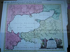
Black Sea,map,Seutter,anno 1730, contemporary coloured Coppermap
Published by Seutter Matth�us, 1678 - 1757, 1730
Map
Hardcover. Condition: Gut. Black Sea,map,Seutter,anno 1730, contemporary coloured Coppermap, edited by Matth�us Seutter, Germany, anno 1730, contemporary coloured, printed on thick paper, little brownish, size of the leaf: 53 x 64 cm., Detailled map of the northern part of the black Sea, Krim, etc. "NOVA MAPPA GEOGRAPHICA MARIS ASSOVIENSIS VEL DE ZABACHE ET PALUDIS MAEOTIDIS, accurate aeri incisa et in huce edita per MATTHAEUM SEUTTER CHAICOGRAPH.".

![Seller image for [Map] "Diversi Globi Terr-Aquei Statione Variante et Visu Intercedente, Per Coluros Tropicorum Per Ambos Polos et Particul, Sphaerae Zenith in Planum Deleati Orthographici Prospectus" from Atlas Minor? for sale by Lloyd Zimmer, Books and Maps](https://pictures.abebooks.com/inventory/md/md17898870225.jpg)