Order Total (1 Item Items):
Shipping Destination:

Seutter Matth�us 1678 1757 (288 results)
Feedback
Skip to main search results
Search filters
Product Type
- All Product Types
- Books (54)
- Magazines & Periodicals (No further results match this refinement)
- Comics (No further results match this refinement)
- Sheet Music (No further results match this refinement)
- Art, Prints & Posters (49)
- Photographs (No further results match this refinement)
- Maps (185)
- Manuscripts & Paper Collectibles (No further results match this refinement)
Condition Learn more
- New (No further results match this refinement)
- As New, Fine or Near Fine (12)
- Very Good or Good (157)
- Fair or Poor (No further results match this refinement)
- As Described (119)
Binding
Collectible Attributes
- First Edition (No further results match this refinement)
- Signed (1)
- Dust Jacket (No further results match this refinement)
- Seller-Supplied Images (242)
- Not Print on Demand (288)
Language (4)
Free Shipping
- Free Shipping to U.S.A. (No further results match this refinement)
Seller Location
Seller Rating
-
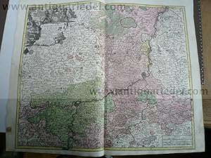
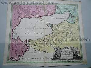
Liege-Maastricht-Brusselles, anno 1740, map by Seutter Matth�us
Published by Seutter Matth�us, 1678 - 1757, 1757
� 89.41
Convert currency� 26.04 shipping from Germany to U.S.A.Quantity: 1 available
Add to basketHardcover. Condition: very good. Liege-Maastricht-Brusselles, anno 1740, map by Seutter Matth�us SEUTTER, G.M. - L'Eveche et L'Etat de Liege Avec les appartenances design�es dans les pais voisins Delineation nouvelle et exacte Aux depens de Matthieu Seutter. Augsburg, 1740. 49 x 61 cm. Contemporary colours Beautiful cooper engraved map of the central part of Belgium and parts of the Netherlands by M. Seutter. Showing the area around Li�ge and Maastricht. The nice cartouche with two Belgium Lions. Printed on thick paper, only little stained, with a small restoration on left margin. Please look the pictures.
-

Brabantiae Ducatus, anno 1740, Seutter M. contemporary colours
Published by Seutter Matth�us, 1678 - 1757, 1757
� 160.95
Convert currency� 26.04 shipping from Germany to U.S.A.Quantity: 1 available
Add to basketHardcover. Condition: Gut. Brabantiae Ducatus, anno 1740, Seutter M. contemporary colours Brabantiae Ducatus Cum Adjacentibus Provinciis studio et impensis Matthaei Seutteri, S. Caes. et Reg. Cathol. Majest. Geographi, Augustae Vindel. Size of the leaf: 53x60 cm., printed on thick paper in publishers colours, clean print, one small restoration on centerfold, not to see in front of the map.
-

Les Routes Exactes des Postes du Royaume de France - Matth�us Se
Published by Seutter Matth�us, 1678 - 1757, 1757
� 178.83
Convert currency� 26.04 shipping from Germany to U.S.A.Quantity: 1 available
Add to basketHardcover. Condition: very good. Les Routes Exactes des Postes du Royaume de France - Matth�us Seutter ca 1740 Altkolorierter Kupferstich, Blatt: 61 x 54 cm, Darstellung: 57 x 45 cm. Dekorative altkolorierte Postkarte von Frankreich mit franz�sischem Titel und Legende im Rand. Sehr sch�nes Altkolorit, gedruckt auf festem Papier. Hinterlegter Einriss, fachm�nnisch restauriert.
-

Paris with environs, streetmap, 1740, Seutter Matth�us
Published by Seutter Matth�us, 1678 - 1757, 1757
� 178.83
Convert currency� 26.04 shipping from Germany to U.S.A.Quantity: 1 available
Add to basketHardcover. Condition: very good. Paris with environs, streetmap, 1740, Seutter Matth�us Carte de la Prevoste et Vicomte de Paris - DreBee fur ungrand nombre de Memoires particudiers aBujettis aux Observations de Mrs. d l Academie Rle des Sciences; Gravee par Matth. Seutter, S. C. et R. Cath. M. Geogr. a Augsbourg. Augsburg, Matthaeus Seutter 1740 - size of the leaf: 53x62 cm. Copper-engraving, handcolored in outline and wash , IN PUBLISHERS COLOURS. Decorative map by the famous cartographer Matthaeus Seutter showing the nearer district around Paris. Showing small place names, villages, casles, monastries, rivers, lakes, streets, etc. THE MAP IS IN EXCELLENT CONDITION, PRINTED ON THICK PAPER, NO CRACS.
-

Condition: Buono (Good). La carta � uno dei rifaciamenti della tavola "Tabula Ducatus Carniola, Vindorum Marchiae et Histriae" di Johann Baptiste Homann realizzata dopo il 1716. acquaforte acquerellata in epoca cm. 58 x 49.5 Buono (Good) Buon es. - piccoli strappi nel margine superiore. Book.
-

Asia,Generalmap,Seutter-Lotter,anno 1750,old colours
Published by Seutter Matth�us, 1678 - 1757, 1757
� 259.30
Convert currency� 26.04 shipping from Germany to U.S.A.Quantity: 1 available
Add to basketHardcover. Condition: Gut. Copperengraving, edited by Seutter-Lotter, Augsburg, approx. anno 1750, full contemporary colours, little brownish, size of the leaf: 21 x 28 cm.
-
� 268.24
Convert currency� 26.04 shipping from Germany to U.S.A.Quantity: 1 available
Add to basketHardcover. Condition: Gut. Coppermap, edited by Seutter Matth�us, anno 1730, size of the leaf: 53 x 62 cm., printed on thick paper, little brownish on margins. Small restauration on verso, in front not to see.
-

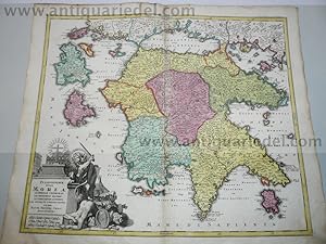
Graeciae pars Meridionalis, 1740, Seutter M., old colours; ed
Published by Seutter Matth�us, 1678 - 1757, 1757
� 312.95
Convert currency� 26.04 shipping from Germany to U.S.A.Quantity: 1 available
Add to basketHardcover. Condition: Gut. Graeciae pars Meridionalis, 1740, Seutter M., old colours; edited by Matth�us Seutter, Augsburg. Comtemporary publishers colours, printed on thick paper, very good condition. Size of the leaf: 52x63 cm.
-
Scotia, anno 1740, map, Seutter M., original colours
Published by Seutter Matth�us, 1678 - 1757, 1757
� 321.89
Convert currency� 26.04 shipping from Germany to U.S.A.Quantity: 1 available
Add to basketHardcover. Condition: Gut. Scotia, anno 1740, map, Seutter M., original colours SEUTTER,M. - Nova et accurata totius Regni Scotiae, Secundum Omnes Provincias et adjacentes Insulas., published in Augsburg 1740. Published : Augsburg 1740. Size: 57 x 49 cm. Very fine, original publishers colours, printed on thick paper, fine print. Fully and strongly engraved copper plate map that includes all of Scotland and the New Hebrides, here called the Western Iles of Scotland. The map is filled with minute detail and hundreds of place names. Embellished with two large and most decorative cartouches with figures, coat of arms, and a compass rose off the mouth of the Fyrth of Forth.
-

� 329.94
Convert currency� 26.04 shipping from Germany to U.S.A.Quantity: 1 available
Add to basketHardcover. Condition: Gut. Italy Generalmap, Seutter Matth�us, a. 1720 Generalmap, edited by Matth�us Seutter, anno 1720, contemporary coloured, Size of the leaf: 53 x 62 cm., printed on thick paper, on upper margin little waterstained, not to see. very scarce map of Italy.
-

Nordeuropa, Schweden, Ostsee, anno 1740, Seutter M., altkolorier
Published by Seutter Matth�us, 1678 - 1757, 1757
� 330.83
Convert currency� 26.04 shipping from Germany to U.S.A.Quantity: 1 available
Add to basketHardcover. Condition: very good. Nordeuropa, Schweden, Ostsee, anno 1740, Seutter M., altkoloriert Nova mappa geographica Sueciae ac Gothiae Regna ut et Finlandiae Ducatum ac Lapponiam, cum provinciis minoribus Seutter, Mathias, 1740 "Nova mappa geographica Sueciae ac Gothiae Regna ut et Finlandiae Ducatum ac Lapponiam, cum provinciis minoribus". Altkol. Kupf.-Kte. von M. Seutter, um 1740. Mit fig. u. herald. Kart. 49,5:57,5 cm., Blatt: 53x62 cm., gedruckt auf festem Papier, sehr sch�nes zeitgen�ssisches Kolorit, etwas fingerfleckig, an den R�ndern von hinten verst�rkt.
-

NOVA ET EXACTISSIMA TOTIUS ITALIAE SARDINIAE ET CORSICAE DELINEATIO OPERA ET IMPENSIS
Published by Augusta, 1730 ca., Augusta, 1730
Condition: Buono (Good). acquaforte acquerellata a mano inciso cm. 57 x 48 - foglio cm. 60,5 x 52,6 Buono (Good) Buon es. Book.
-
� 348.71
Convert currency� 26.04 shipping from Germany to U.S.A.Quantity: 1 available
Add to basketHardcover. Condition: Gut. Morea,Peloponnes,map, Seutter,anno 1730 Coppermap, edited by Matth�us Seutter, anno 1730, size of the leaf 53 x 62 cm., nice, contemporary coloured. little brownish on margins, upper margin little waterstained.
-
� 348.71
Convert currency� 26.04 shipping from Germany to U.S.A.Quantity: 1 available
Add to basketHardcover. Condition: Gut. Philippsburg, anno 1730, Seutter Matth�us, Blattma�: 51x60 cm.
-
Mediolanensis,Venetia,map,Seutter anno 1720,old coloured
Published by Seutter Matth�us, 1678 - 1757, 1757
� 348.71
Convert currency� 26.04 shipping from Germany to U.S.A.Quantity: 1 available
Add to basketHardcover. Condition: Gut. Original coppermap, edited by Matth�us Seutter, anno 1720, printed on thick paper, contemporary full coloured, very good condition, no cracs or tears, centerfold ok., little brownish on margins. To see northern Italy with the italian lakes and Venetia. Below margins: Parma, Modena, Bologna.
-
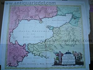
Black Sea,map,Seutter,anno 1730, contemporary coloured Coppermap
Published by Seutter Matth�us, 1678 - 1757, 1730
Map
� 356.76
Convert currency� 26.04 shipping from Germany to U.S.A.Quantity: 1 available
Add to basketHardcover. Condition: Gut. Black Sea,map,Seutter,anno 1730, contemporary coloured Coppermap, edited by Matth�us Seutter, Germany, anno 1730, contemporary coloured, printed on thick paper, little brownish, size of the leaf: 53 x 64 cm., Detailled map of the northern part of the black Sea, Krim, etc. "NOVA MAPPA GEOGRAPHICA MARIS ASSOVIENSIS VEL DE ZABACHE ET PALUDIS MAEOTIDIS, accurate aeri incisa et in huce edita per MATTHAEUM SEUTTER CHAICOGRAPH.".
-

Frankfurt mit Umgebung, anno 1740, Seutter Matth�us 'Territoriu
Published by Seutter Matth�us, 1678 - 1757, 1757
� 357.66
Convert currency� 26.04 shipping from Germany to U.S.A.Quantity: 1 available
Add to basketHardcover. Condition: Gut. Frankfurt mit Umgebung, anno 1740, Seutter Matth�us 'Territorium Sac. Rom. Imp. Lib. Civitatis Francofurti Ad Moenum cum magna parte Archiepiscopatus Moguntini, Comitatus Hanoviensis aliarumq regionum finitimarum, accuratissime delineavit Matthaeus Seutter, Sac. Caes. Maj. Geogr. Aug. Vind. C.Gr. et Pr. S.R.I. Vicar in part Rheni Sveviae et Juris Franconici. Zeigt den Gro�raum Frankfurt mit dem Mainlauf von Hanau bis Kelsterbach. - Frankfurt, Hanau und H�chst mit Befestigungspl�nen. Im S�dosten noch mit Babenhausen; im Nordwesten mit Kronberg, Oberursel, Bad Homburg. - Unten links Titelkartusche mit Allegorien und Wappen. Blattma�: 53x60 cm., sehr sch�nes Verlagskolorit, an den R�ndern etwas gebr�unt.
-
� 357.66
Convert currency� 26.04 shipping from Germany to U.S.A.Quantity: 1 available
Add to basketHardcover. Condition: Gut. "Regnum Hiberniae, anno 1740, map, Seutter Matth�us "Regnum Hiberniae, tam Secundum IV Provincias Principales Ultoniam, Connaciam, Lageniam, Momoniam" The title cartouche supports the royal British arms and the large pictorial cartouche at bottom presents a bucolic scene of Mercury with herdsmen, shepherds and fishermen and supports the Irish coat of arms. Printed in original publishers colours, printed on thick paper, good condition, two small restorations on centerfold. Size of the leaf: 53x63 cm.".
-
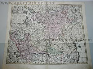
Bavaria Superior et Inferior, 1740, Seutter M., altkoloriert
Published by Seutter Matth�us, 1678 - 1757, 1757
� 375.54
Convert currency� 26.04 shipping from Germany to U.S.A.Quantity: 1 available
Add to basketHardcover. Condition: Gut. Bavaria Superior et Inferior, 1740, Seutter M., altkoloriert Bavaria Superior et Inferior cum Quatuor Praefecturis juxta recentissimam Designationem ob oculus posita per Matthaeum Seutter, Sac. Caes. et Cathol. Reg. Majest. Geographum Augustae Vindel. Blattma�: 53x62 cm., gedruckt auf dickem Papier, in Verlagskolorit der Zeit,bis auf ein kleines hinterlegtes L�chleinausgezeichneter Erhaltungszustand.
-
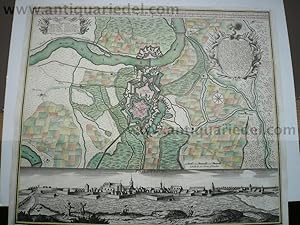
Augsburg, Panorama+Karte, anno 1730, Seutter M., selten verlegt
Published by Seutter Matth�us, 1678 - 1757, 1757
� 402.36
Convert currency� 26.04 shipping from Germany to U.S.A.Quantity: 1 available
Add to basketHardcover. Condition: Gut. Augsburg, Panorama+Karte, anno 1730, Seutter M., selten verlegt bei Seutter M., in Augsburg, ca. 1730: "Prospect de� Heil. R�m. Reichs freyen Stadt Augsburg wie solche von morgen her anzusehen. -Kopftitel: Augspurg die Haupt-Stadt und Zierde des Schw�bischen Craises, samt der umliegenden Gegend." Sehr guter Erhaltungszustand, gedruckt auf dickem Papier, altkoloriert. Blattma�: 50x60 cm Referenz: Fauser, Nr. 882. Sehr sch�nes, kr�ftiges Kolorit, gedruckt auf dickem Papier, einige Reparaturen am Fu�, kleiner Feuchtigkeitsfleck.
-
Italiae antique item Insularum, 1740, Seutter M., old colours
Published by Seutter Matth�us, 1678 - 1757, 1757
� 402.36
Convert currency� 26.04 shipping from Germany to U.S.A.Quantity: 1 available
Add to basketHardcover. Condition: Gut. Italiae antique item Insularum, 1740, Seutter M., old colours Itali� antique item insularum Sicili�, Sardini�, Corsic�, typus et nova delineatio ; cum gratia et privil. S. R. I. vicariat[us], in partib[us] Rheni, Svevi�, et juris Franconici ; �ri insculpta per Matth�um Seutter, S. c�s. et reg. Italien ; Geschichte Altertum Title: Itali� antique item insularum Sicili�, Sardini�, Corsic�, typus et nova delineatio ; Kartenmaterial ; cum gratia et privil. S. R. I. vicariat[us], in partib[us] Rheni, Svevi�, et juris Franconici ; �ri insculpta per Matth�um Seutter, S. c�s. et reg. cathol. Majest. geographum Size of the leaf: 52x63 cm., in original publishers colours, little brownish. Scarce map.
-
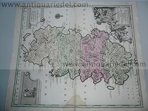
Sardinia, Isle, anno 1730, Seutter Matth�us, scarce map
Published by Seutter Matth�us, 1678 - 1757, 1757
� 438.13
Convert currency� 26.04 shipping from Germany to U.S.A.Quantity: 1 available
Add to basketHardcover. Condition: Gut. Sardinia, Isle, anno 1730, Seutter Matth�us, scarce map Coppermap, edited by Matth�us Seutter, anno 1730, contemporary full coloured, printed on thick paper, little waterstained on centerfold. Size of the leaf: 53 x 62 cm., very scarce map of the isle Sardinia.
-
Black Sea,map,Seutter,anno 1730, contemporary coloured
Published by Seutter Matth�us, 1678 - 1757, 1757
� 438.13
Convert currency� 26.04 shipping from Germany to U.S.A.Quantity: 1 available
Add to basketHardcover. Condition: Gut. Black Sea,map,Seutter,anno 1730, contemporary coloured Coppermap, edited by Matth�us Seutter, Germany, anno 1730, contemporary coloured, printed on thick paper, little brownish, size of the leaf: 53 x 64 cm., Detailled map of the northern part of the black Sea, Krim, etc. "NOVA MAPPA GEOGRAPHICA MARIS ASSOVIENSIS VEL DE ZABACHE ET PALUDIS MAEOTIDIS, accurate aeri incisa et in huce edita per MATTHAEUM SEUTTER CHAICOGRAPH.".
-
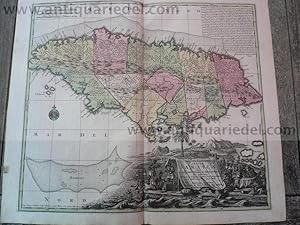
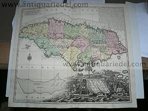
Jamaica-anno 1740, map Seutter Matth�us, old colours
Published by Seutter Matth�us, 1678 - 1757, 1757
� 447.07
Convert currency� 26.04 shipping from Germany to U.S.A.Quantity: 1 available
Add to basketHardcover. Condition: very good. Jamaica-anno 1740, map Seutter Matth�us, old colours NOVA DESIGNATIO INSULA JAMAICAE EX ANTILLIANIS AMERICAE SEPTENTRION, G. M. Seutter., Augsburg. A handsome map of the island of Jamaica by a premier 18th century mapmaker, Mathias Seutter (1678-1756). The map shows Jamaica divided into precincts and details topographical features of mountains, forests, rivers & small settlements. Around the coasts the map indicates harbors, bays with depth soundings, shoals & small offshore islands. Size of the leaf: 53x62 cm., printed on thick paper, no cracs, publishers colours.
-
Jamaica-anno 1740, map Seutter Matth�us, old colours NOVA DESIGN
Published by Seutter Matth�us, 1678 - 1757, 1757
� 491.78
Convert currency� 26.04 shipping from Germany to U.S.A.Quantity: 1 available
Add to basketHardcover. Condition: Gut. Jamaica-anno 1740, map Seutter Matth�us, old colours NOVA DESIGNATIO INSULA JAMAICAE EX ANTILLIANIS AMERICAE SEPTENTRION, G. M. Seutter., Augsburg. A handsome map of the island of Jamaica by a premier 18th century mapmaker, Mathias Seutter (1678-1756). The map shows Jamaica divided into precincts and details topographical features of mountains, forests, rivers & small settlements. Around the coasts the map indicates harbors, bays with depth soundings, shoals & small offshore islands. Size of the leaf: 53x62 cm., printed on thick paper, no cracs, publishers colours.
-
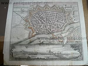
Ulm, anno 1740, Plan+Panorama, Seutter M., altkoloriert, selten
Published by Seutter Matth�us, 1678 - 1757, 1757
� 715.31
Convert currency� 26.04 shipping from Germany to U.S.A.Quantity: 1 available
Add to basketHardcover. Condition: Gut. Ulm, anno 1740, Plan+Panorama, Seutter M., altkoloriert, selten "Ulma memorabilis ac permunita libera Imperii Civitas ad Danubium,." ".Ulm eine considerable Freye Reichs Statt in Schwabnen,." Verlegt von Seutter Matth�us, Augsburg, ca. anno 1740, Platte: 485x565 mm., Blatt: 570x650 mm., altkoloriert, etwas stockfleckig, div. rest. Randl�suren. Referenz: Fauser, Nr. 14 452.
-
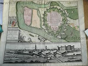
� 536.48
Convert currency� 26.04 shipping from Germany to U.S.A.Quantity: 1 available
Add to basketHardcover. Condition: Gut. Mannheim, anno 1740, Seutter Mannheim. Manheimium, Plan, darunter Gesamtansicht. Kupferstich, der Plan koloriert, von M. Seutter, um 1740. Plattengr��e ca. 49,5 x 58 cm, Blattgr��e ca. 53,5 x 65 cm. Altersspuren, im Passepartoutausschnitt leicht lichtrandig und gebr�unt, stellenweise etwas feuchtfleckig, verso beschriftet und aquarelliert.
-
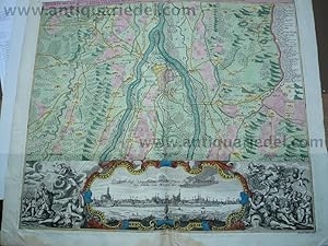
Praha/Praque/Prag, anno 1740, map, Seutter Matth�us, old colours
Published by Seutter Matth�us, 1678 - 1757, 1757
� 625.90
Convert currency� 26.04 shipping from Germany to U.S.A.Quantity: 1 available
Add to basketHardcover. Condition: Gut. Praha/Praque/Prag, anno 1740, map, Seutter Matth�us, old colours Pragae Metropolis regni Bohemiae cum adjacentibus terris accurata descriptio geographica cura et studio Matth. Seutter. S. C. M. Geogr. Aug. Vindel. Map of Prague, environs of Bohemia, Prague Region, Czech Republic Cartographer Seutter, Matthaeus (1678-1756) Date Original circa 1740 Place of Publication Augsburg Dimensions 50 x 57 cm. Very good condition, in contemporary colours.
-
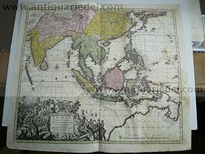
India orientalis,map,Seutter,anno 1740,with Australia Coppermap,
Published by Seutter Matth�us, 1678 - 1757, 1757
� 760.02
Convert currency� 26.04 shipping from Germany to U.S.A.Quantity: 1 available
Add to basketHardcover. Condition: Gut. India orientalis,map,Seutter,anno 1740,with Australia Coppermap, edited by Matth�us Seutter: "INDIA ORIENTALIS,CUM ADJACENTIBUS INSULIS NOVA DELINEATIONE ob oculos posita PER MATTHAEUM SEUTTER, S.C.M.GEOGR.AUGUST." Size of the leaf: 53 x 62 cm., of the map: 46 x 55 cm., contemporary full coloured, printed on thick paper, little restorations on below centerfold, the map is a little waterstained, small restored wormhole. Please look the pictures. Map of East Indies with Japan and Australia. To see Japan and Persia in the North, the Maldives in the West, Australia in the south. Australia called Nova Hollandia.
-
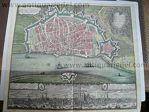
Antwerp/Antwerpen, anno 1740, original map, Seutter Matth�us
Published by Seutter Matth�us, 1678 - 1757, 1757
� 1,743.57
Convert currency� 26.04 shipping from Germany to U.S.A.Quantity: 1 available
Add to basketHardcover. Condition: very good. Antwerp/Antwerpen, anno 1740, original map, Seutter Matth�us SEUTTER, M - Plan de la Ville et Citadelle d'Anvers Renomee pour fon ports Comerce et edifices La citadelle est des plus fortes au monde, grave en taille douce. Published : Augsburg, 1740. Size : 53.3 x 60.7 cm. Colouring : Original color, publishers color Detailed city map of the city of Anvers (now Antwerp), Belgium, surrounded by walls and moats, from Mathaus Seutter's Grosser Atlas. A view of the bustling port of Antwerp in shown in the bottom section. Condition : very good, no cracs or tears.