
Order Total (1 Item Items):
Shipping Destination:

Scull Nicholas (37 results)
Feedback
Skip to main search results
Search filters
Product Type
- All Product Types
- Books (36)
- Magazines & Periodicals (No further results match this refinement)
- Comics (No further results match this refinement)
- Sheet Music (No further results match this refinement)
- Art, Prints & Posters (No further results match this refinement)
- Photographs (No further results match this refinement)
- Maps (1)
- Manuscripts & Paper Collectibles (No further results match this refinement)
Condition
Binding
Collectible Attributes
- First Edition (8)
- Signed (No further results match this refinement)
- Dust Jacket (7)
- Seller-Supplied Images (15)
- Not Print on Demand (31)
Language (2)
Free Shipping
Seller Location
Seller Rating
-
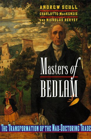
Masters of Bedlam: The Transformation of the Mad-Doctoring Trade (Princeton Legacy Library)
Published by Princeton University Press 03/01/1999, 1999
ISBN 10: 0691002517 ISBN 13: 9780691002514
Language: English
Paperback. Condition: Very Good. Shipped within 24 hours from our UK warehouse. Clean, undamaged book with no damage to pages and minimal wear to the cover. Spine still tight, in very good condition. Remember if you are not happy, you are covered by our 100% money back guarantee.
-
Masters of Bedlam (Princeton Legacy Library)
Published by Princeton University Press, 1996
ISBN 10: 0691034117 ISBN 13: 9780691034119
Language: English
� 5.67
Convert currency� 10.51 shipping from U.S.A. to United KingdomQuantity: 1 available
Add to basketHardcover. Condition: Good. No Jacket. Missing dust jacket; Pages can have notes/highlighting. Spine may show signs of wear. ~ ThriftBooks: Read More, Spend Less 1.55.
More buying choices from other sellers on AbeBooks
Used offers from � 16.18
Also find Hardcover First Edition
-
Masters of Bedlam: The Transformation of the Mad-Doctoring Trade (Princeton Legacy Library)
Published by Princeton University Press, Princeton, NJ, 1996
ISBN 10: 0691034117 ISBN 13: 9780691034119
Language: English
First Edition
� 32.98
Convert currency� 26.07 shipping from U.S.A. to United KingdomQuantity: 1 available
Add to basketHardcover. Condition: As New. Dust Jacket Condition: As New. 1st Edition.
-

Masters of Bedlam : The Transformation of the Mad-doctoring Trade
Published by Princeton University Press, 2014
ISBN 10: 0691608962 ISBN 13: 9780691608969
Language: English
Seller: GreatBookPricesUK, Woodford Green, United Kingdom
Seller rating 5 out of 5 stars

Condition: New.
More buying choices from other sellers on AbeBooks
New offers from � 58.39
Used offers from � 62.11
Also find Softcover
-

Masters of Bedlam: The Transformation of the Mad-Doctoring Trade
Published by Princeton Univ. Press (1996) Princeton, NJ, 1996
ISBN 10: 0691034117 ISBN 13: 9780691034119
Seller: Prairie Archives, Springfield, IL, U.S.A.
Association Member: MWABA
Seller rating 4 out of 5 stars

First Edition
� 9.20
Convert currency� 34.44 shipping from U.S.A. to United KingdomQuantity: 1 available
Add to basketVery good in very lightly edgeworn jacket. First Printing Cloth.
-

Masters of Bedlam
Published by Princeton University Press, 2017
ISBN 10: 0691637326 ISBN 13: 9780691637327
Language: English
Seller: Kennys Bookshop and Art Galleries Ltd., Galway, GY, Ireland
Seller rating 5 out of 5 stars
� 222.69
Convert currency� 2.61 shipping from Ireland to United KingdomQuantity: 15 available
Add to basketCondition: New. Series: Princeton Legacy Library. Num Pages: 376 pages, 17 halftones. BIC Classification: JMAF; MMH. Category: (P) Professional & Vocational; (U) Tertiary Education (US: College). Dimension: 229 x 152 x 22. Weight in Grams: 685. . 2017. Hardback. . . . .
-

This is not available 022187
Published by Proquest, Umi Dissertation Publishing, 2011
ISBN 10: 1243673303 ISBN 13: 9781243673305
Language: English
Seller: Phatpocket Limited, Waltham Abbey, HERTS, United Kingdom
Seller rating 5 out of 5 stars
Condition: Like New. Used - Like New. Book is new and unread but may have minor shelf wear. Your purchase helps support Sri Lankan Children's Charity 'The Rainbow Centre'. Our donations to The Rainbow Centre have helped provide an education and a safe haven to hundreds of children who live in appalling conditions.
-
An East Prospect of the City of Philadelphia: taken by George Heap from the Jersey Shore, under the Direction of Nicholas Skull [sic] Surveyor General of the Province of Pennsylvania
Published by Engraved by G. Vandergucht, [London], 1754
Map First Edition
� 724,876.19
Convert currency� 26.07 shipping from U.S.A. to United KingdomQuantity: 1 available
Add to basketNo binding. Condition: Near fine. First. "THE MOST DISTINGUISHED OF ALL PRINTS OF THE CITY OF PHILADELPHIA" [London:] Engraved by G. Vandergucht, Sep.br 1.st 1754. First state ("Skull" for "Scull" twice on sheet 3). Four sheets (ca. 29 1/2" x 23 1/2" each). Framed floating. An old transverse crease about 9" below the top edge, reinforced verso. Some small repairs to the sky. Tanning at the corners from an early mount. With good upper and lower margins throughout; sheets 1-3 trimmed to right-hand plate-mark; sheet 4 trimmed to left-hand plate-mark. Occasional very mild patches of tanning. An extraordinary set. From its founding in 1680 between the Delaware and Schuylkill Rivers, Philadelphia was strategically poised to be a hub of trade. By the mid-XVIIIc it had become the major Atlantic port, fueling a golden age of growth and eminence in the arts and sciences -- the Athens of America. The Penn family had long dominated the colony, and Thomas Penn, the founder's son, commissioned a grand view of the city in 1750 to commemorate and to enhance its stature (the Penn arms at the lower left corner of the third plate underscore their dominance). George Heap undertook the project; he had been Philadelphia's coroner. The ambition of the project matched the city's stature: it was the grandest illustrated view of an American city that had ever been attempted. Nicholas Scull (perhaps an uncle by marriage) superintended the work, and Heap began advertising for subscribers (20 shillings, 10 payable in advance) and with that money set sail for England (there being no means to print it in Philadelphia) with his drawings. Heap got only as far as Delaware, and died on-board; he was buried in Philadelphia on Boxing Day 1752. Thereafter Scull shepherded the vast work through the engraving and publishing process. The Dutch engraver Gerard Vandergucht was commissioned to cut the plates, which finally emerged in June of 1754 (the King hung it in his own apartments). Wainright begins his article on the prospect by hailing it as "the most distinguished of all prints of the city of Philadelphia in terms of age, rarity, and historic importance." In 1755 the view was shrunk by about two-thirds, and placed above a plan of the city and a view of the state house and the batter, engraved by Thomas Jefferys. This is far more common; of the Heap-Scull-Vandergucht view we have located only six copies in institutional collections: the American Philosophical Society (.748:P53:1754), Haverford College, Colonial Williamsburg, the Historical Society of Pennsylvania (second state), Independence National Historic Park and the New York Public Library (Stokes Collection, second state). De�k I:99 (second state). See Wainright, Nicholas B. "Scull and Heap's East Prospect of Philadelphia" in The Pennsylvania Magazine of History and Biography 73, no. 1 (January 1949) 16-25.
-

A map of Philadelphia and parts adjacent.
Seller: Libreria Oreste Gozzini snc, Firenze, FI, Italy
Seller rating 5 out of 5 stars
First Edition
� 340.04
Convert currency� 8.69 shipping from Italy to United KingdomQuantity: 1 available
Add to basket[London], [Gentleman's Magazine], [1777], carta geografica dei dintorni di Filadelfia, incisa in rame, mm 338x296 (l'immagine), mm 370x297 (il foglio). Forse la mappa pi� famosa di Filadelfia, la carta di Scull e Heap ha avuto numerose edizioni, a partire dalla prima del 1752. La seconda edizione apparve nel numero di agosto 1753 del Gentleman's Magazine di Londra; la terza - di cui fa parte questa che mettiamo in vendita - fu pubblicata, sempre nel Gentleman's Magazine, nel 1777. Poich� la prima edizione della mappa, pubblicata separatamente a Filadelfia, � molto rara, l'edizione del Gentleman's Magazine � la prima versione di questa importante carta ad essere generalmente disponibile. La planimetria a griglia per la citt� si trova al centro della mappa, con una piazza centrale aperta e il Tribunale come unici elementi indicati. Vengono fornite ulteriori informazioni sulle aree circostanti, dove vengono mostrate e nominate strade, mulini e case di cittadini illustri. Questi dettagli ci forniscono una miniera di informazioni sullo sviluppo dell'area di Filadelfia agli albori. Particolarmente interessante � la notevole urbanizzazione di Germantown, con case che si affacciano su entrambi i lati di Germantown Pike. La prima edizione includeva una tabella delle distanze dal Tribunale nell'angolo in basso a destra. La seconda edizione sostituisce la tabella con i dettagli delle strade del New Jersey, ecc. Piccolo restauro reintegrativo nella parte superiore sinistra, ai margini del foglio.
-

A Map of Pennsylvania, Exhibiting Not Only the Improved Part of That .
Published by London, London, 1775
Seller: High Ridge Books, Inc. - ABAA, South Deerfield, MA, U.S.A.
Association Member: ABAA ESA ILAB SNEAB
Seller rating 5 out of 5 stars
First Edition
� 2,684.73
Convert currency� 26.07 shipping from U.S.A. to United KingdomQuantity: 1 available
Add to basket3 sheet map, backed and joined. Some damage and loss, repaired at edges, lower right corner defective, affecting border and some surface, but no text. Outline color. An important map in the history of Pennsylvania. a map oft referred to as the 'Revolutionary War map' of the state. The information depicted on the map is far and away the most comprehensive and accurate for any map of Pennsylvania to that date, and for years thereafter; a fact that in part reflects its history. In 1759, Nicolas Scull, the Surveyor General of Pennsylvania and William Scull's grandfather, issued a map of the eastern parts of Pennsylvania commissioned by the colony's government. This was based to a great extent upon Nicolas' surveys and other first hand information, making it the standard for all subsequent maps. About ten years later, William Scull produced an updated map of Pennsylvania, basing it upon his grandfather's map as well as on his own new surveys and other information. The first edition of this map, issued in small numbers, is extremely scarce and valuable. Five years later, Sayer and Bennett issued this further updated edition in Jefferys' North American Atlas of 1775.
-
A Plan of the City of Philadelphia.
Published by Andrew Dury (fl. 1754-1777), London, 1776
Seller: Arader Galleries of Philadelphia, PA, Philadelphia, PA, U.S.A.
Seller rating 5 out of 5 stars
� 9,588.31
Convert currency� 26.07 shipping from U.S.A. to United KingdomQuantity: 1 available
Add to basketN/A. Condition: Very Good. Benjamin Eastburn, Surveyor General (but after Nicholas Scull, Matthew Clarkson and Mary Biddle) A Plan of the City of Philadelphia. Published Andrew Dury (fl. 1754-1777), London, 1776 Engraving with original hand-coloring, includes inset view of Delaware Bay. Includes inset view of Delaware river and bay, after Joshua Fisher p.m. 20 1/4 x 26 3/4� Frame size 30 5/8 x 36 3/4� In 1776 Philadelphia was the largest city in North America, the second largest city in The British Empire, and the seat of the Continental Congress. This scarce, large-scale plan of Philadelphia, published just four months after the signing of the Declaration of Independence, provided "the best picture of the city available on the eve of the British occupation" -- Nebenzahl. In the upper left is a reduced version of Fisher's plan of Delaware Bay. The publisher, Andrew Dury, based his map on the 1762 Clarkson-Biddle engraving of Scull's famous survey, but either in error or to avoid paying royalties to Scull, Dury attributed the survey to Scull's predecessor Benjamin Eastburn, who had been dead for thirty-five years. ref: Nebenzahl, Atlas of The American Revolution, #27; Snyder, City of Independence, #44.
-
An East Prospect of the City of Philadelphia; taken by George Heap from the Jersey Shore, under the Direction of Nicholas Scull, Surveyor General of the Province of Pennsylvania
Published by Thomas Jefferys, 1756
Seller: Arader Galleries of Philadelphia, PA, Philadelphia, PA, U.S.A.
Seller rating 5 out of 5 stars
� 111,224.39
Convert currency� 26.07 shipping from U.S.A. to United KingdomQuantity: 1 available
Add to basketNo Binding. Condition: Very Good. Dust Jacket Condition: Very Good. Black and white copper-engraving (1756-68). Sheet size: 22 3/4 x 38". Inventory#: p405pmat. "Probably the finest view of an American city made before the Revolution" (Swift and McCusker). It was separately issued in 1756, and also appeared in Jeffrey's "A General Topography of North America", 1768. Both issues are very rare. The Sheet consists of a grand view of Philadelphia from the New Jersey shore along the upper margin (the "East Prospect"), which is admirably supplemented by a plan of the city (lower left), and fine views of "The State House" (lower right), and "The Battery" (lower center). The view proper (the "East Prospect") is adapted from Scull and Heap's mammoth earlier view of the city on six sheets, 1754, but with revisions suggested in the main by Thomas Penn. The size was reduced to one large but manageable sheet, the supplementary views and plan were added, and the view itself revised to include the Jersey shore of the Delaware River. The latter alteration was made so that the city would clearly be seen as a protected river port. 0.
-
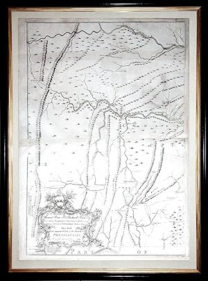
Map of the improved Part of the Province of Pennsylvania.
Published by Philadelphia: Engraved by Jas. Turner and Printed by John Davis for the Author; Published & Sold by the Author, Nicholas Scull, 1 January 1759., 1759
Seller: Arader Galleries - AraderNYC, New York, NY, U.S.A.
Seller rating 5 out of 5 stars
First Edition
� 103,553.74
Convert currency� 26.07 shipping from U.S.A. to United KingdomQuantity: 1 available
Add to basket6 sheets joined in pairs to make three maps (each map size: 31 x 22 inches; each framed size: 36 x 26 4/8 inches). EXCEPTIONALLY FINE engraved map of Pennsylvania, the title within an elaborate asymmetrical rococo cartouche lower left, a large compass rose centre right, showing Pennsylvania extending west to the Allegheny Mountains and beyond Fort Cumberland in north central Maryland, bounded by Maryland along the bottom edge and New Jersey on the right. "THE FIRST MAP OF PENNSYLVANIA TO BE PUBLISHED IN AMERICA [AND] THE MOST AMBITIOUS CARTOGRAPHICAL WORK TO COME FROM AN AMERICAN SOURCE BEFORE THE REVOLUTION" (Wroth) The first state, before the addition of text by Nelson's Ferry at the southern end of the Susquehanna River, and VERY RARE. This was the first map of Pennsylvania to be published in America and arguably the most ambitious cartographical work to come from an American source before the Revolution. Nicholas Scull, Jr. (1687-1761) was born in Philadelphia to Nicholas Scull, Sr. the surveyor and mapmaker, who had been apprenticed to William Penn's surveyor, Thomas Holme. In 1719, he became deputy surveyor of Philadelphia County, eventually ascending to the Surveyor Generalship of Pennsylvania in 1748. A bibliophile, he was an original member of Benjamin Franklin's Junto. Scull was intimately involved with Indian relations for the colony, having travelled amongst the tribes to survey the western counties. He was knowledgeable in several local Native languages. But in the dispute that arose about the infamous Walking Purchase of 1737, at which he was present, his recollections favored the Proprietors. This is hardly surprising but it no doubt put him in a good position with the Penn family, and it is thought that this may have led to the publication of this impressive map. It was the first map of Pennsylvania since Thomas Holmes 1687 map of the then much smaller settlement, and represents a vast amount of on-site surveying. Dedicated to the Penn brothers, Scull's map is among the largest and finest maps produced in America in the 18th century. It was an extraordinary achievement. The map depicts Philadelphia, Bucks, Northampton, Berks, Chester, Lancaster, Cumberland, and York Counties, and is based on Sculls own surveys, as well as the contributions of several others (whom he acknowledges). Some information was gleaned from printed sources, including Fry-Jefferson's important map, evidenced by a printed footnote concerning the location of Fort Cumberland and the Maryland-Pennsylvania border. Elevation is accurately depicted, much in the style of Fry-Jefferson, by neat hachuring marks. The eastern counties include a wealth of detail, such as churches, meeting houses, inns, iron forges, mills and the manors of significant residents; roads, Indian paths, Indian towns and forts: all clearly shown throughout. Although generally quite accurate, it is curious that Scull included Fort Granville on his map, which had been destroyed by the French and Delaware Indians in 1756. Nevertheless, the importance and accuracy of this large- scale map is underscored by the fact that a copy of it was among the maps hung by the Board of War at Philadelphia in August 1776, twenty years after the maps publication (as noted by John Adams in his letter to his wife dated 13 August 1776). The map was engraved by James Turner (d. 1759), a Philadelphia silversmith and protege of Benjamin Franklin. Turner had previously worked on map engraving during the production of James Parker's 1747 maps of New Jersey, a project for which he had been recommended by Franklin. Little is known about the printer John Davis. Although he had no shop, he appears to have specialized in large copperplate engravings of maps, as he is the printer identified in the imprint of the 1756 Philadelphia first edition of Joshua Fishers important chart of Delaware Bay. That map and the present one are his only known works. Nicholas Sculls grandson William Scull revised and.

![Seller image for An East Prospect of the City of Philadelphia: taken by George Heap from the Jersey Shore, under the Direction of Nicholas Skull [sic] Surveyor General of the Province of Pennsylvania for sale by Arader Books](https://pictures.abebooks.com/inventory/md/md30901384945.jpg)