
Order Total (1 Item Items):
Shipping Destination:

Probst Johann Michael (14 results)
Feedback
Skip to main search results
Search filters
Product Type
- All Product Types
- Books (4)
- Magazines & Periodicals (No further results match this refinement)
- Comics (No further results match this refinement)
- Sheet Music (No further results match this refinement)
- Art, Prints & Posters (2)
- Photographs (No further results match this refinement)
- Maps (8)
- Manuscripts & Paper Collectibles (No further results match this refinement)
Condition Learn more
- New (1)
- As New, Fine or Near Fine (5)
- Very Good or Good (2)
- Fair or Poor (No further results match this refinement)
- As Described (6)
Binding
- All Bindings
- Hardcover (2)
- Softcover (No further results match this refinement)
Collectible Attributes
- First Edition (No further results match this refinement)
- Signed (No further results match this refinement)
- Dust Jacket (No further results match this refinement)
- Seller-Supplied Images (13)
- Not Print on Demand (13)
Language (2)
Free Shipping
Seller Location
Seller Rating
-
� 25.60
Convert currencyFree shipping from India to United KingdomQuantity: Over 20 available
Add to basket -

Neue Post Karte von Bayern.
Published by Augsburg, 1797., 1797
Seller: Antiquariat INLIBRIS Gilhofer Nfg. GmbH, Vienna, A, Austria
Association Member: ILAB VDA VDAO
Seller rating 5 out of 5 stars

� 445.80
Convert currency� 25.97 shipping from Austria to United KingdomQuantity: 1 available
Add to basket570 x 510 mm. Gestochene Karte in 16 Segmenten, auf Leinen aufgezogen und gefaltet.
-

Italien in seine unterschiedene Laender eingetheilet
Published by Probst, Augsburg, 1780
Seller: Antikvariat Krenek, Prag, Czech Republic
Association Member: ILAB
Seller rating 5 out of 5 stars
Map
� 111.46
Convert currency� 10.82 shipping from Czech Republic to United KingdomQuantity: 1 available
Add to basketKein Einband. Condition: Gut bis sehr gut. Italy. "Italien in seine unterschiedene Laender eingetheilet". Orig. copperplate engraving, J. M. Probst, Augsburg, ca. 1780. Engraved by J. G. Probst. Orig. old colouring. With decorative title cartouche and explanatory notes on the right. 17,5:25 cm (6 3/4 x 9 3/4 inch.). A map of Italy.
-

Gros Britan . oder Engelland
Published by Probst, Augsburg, 1785
Seller: Antikvariat Krenek, Prag, Czech Republic
Association Member: ILAB
Seller rating 5 out of 5 stars
Map
� 148.61
Convert currency� 10.82 shipping from Czech Republic to United KingdomQuantity: 1 available
Add to basketKein Einband. Condition: Gut bis sehr gut. Great Britain and Ireland. "Gros Britan. oder Engelland, Schot zu Irrla.". Orig. copperplate engraving. Engraved by J. G. Probst, 1785, published by J. M. Probst in Augsburg. Orig. old colouring. With decorative title cartouche wit a coat of arms, inset map of Orkney Islands, a wind rose and explanatory notes on the right. 16:23,5 cm (6 1/4 x 9 1/4 inch.). A map of Great Britain and Ireland.
-
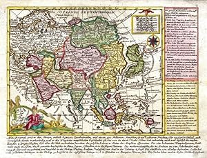
Asia verlegt von Ioh. Mich. Probst
Published by Probst, Augsburg, 1785
Seller: Antikvariat Krenek, Prag, Czech Republic
Association Member: ILAB
Seller rating 5 out of 5 stars
Map
� 222.92
Convert currency� 10.82 shipping from Czech Republic to United KingdomQuantity: 1 available
Add to basketKein Einband. Condition: Sehr gut. Asia. "Asia verlegt von Ioh. Mich. Probst". Orig. copperplate engraving. Published by J. M. Probst in Augsburg, ca. 1785. Orig. old colouring. With figure title cartouche and a cartouche with the scale of map, a wind rose and explanatoty notes on the right and under the map. 15,5:19 cm (6 1/4 x 7 1/2 inch. - the map); 18:24 cm (7 x 9 1/2 inch. - whole plate, including explanatory notes). A map of Asia.
-

Der Fraenkische Kreis
Published by Probst, Johann Michael, Augsburg, 1789
Seller: Antikvariat Krenek, Prag, Czech Republic
Association Member: ILAB
Seller rating 5 out of 5 stars
� 241.50
Convert currency� 10.82 shipping from Czech Republic to United KingdomQuantity: 1 available
Add to basketBayern. Franken. "Der Fraenkische Kreis. Nach seiner dermaligen L�nder Eintheilung". Altkol. kupferstich Karte bei J. M. Probst, Augsburg, 1789. Gest. von J. G. Probst. Mit dekorative Titelkart., kl. Nebenkarte (9:7 cm), Meilenanzeiger und Erkl�rungen. 50:57 cm. In der oberen linken Ecke und am linken Rand handschriftliche Bemerkungen aus dem fr�hen 19. Jahrhundert. - Karte von Franken mit befestigte St�dte (u. a. W�rzburg, Bamberg, N�rnberg, Regensburg).
-

Africa verlegt von Ioh. Mich. Probst
Published by Probst, Augsburg, 1785
Seller: Antikvariat Krenek, Prag, Czech Republic
Association Member: ILAB
Seller rating 5 out of 5 stars
Map
� 260.07
Convert currency� 10.82 shipping from Czech Republic to United KingdomQuantity: 1 available
Add to basketKein Einband. Condition: Gut bis sehr gut. Africa. "Africa verlegt von Ioh. Mich. Probst". Orig. copperplate engraving. Published by J. M. Probst in Augsburg, ca. 1785. Orig. old colouring. With figure title cartouche and a cartouche with the scale of map, explanatoty notes on the right and under the map. 16:20,5 cm (6 1/4 x 8 inch. - the map); 18:24 cm (7 x 9 1/2 inch. - whole plate, including explanatory notes). A map of Africa.
-
Landkarte Bayern 1797: Johann Michael Probst, Neue Post-Karte von Bayern
Published by Augsburg 1797, 1797
Seller: Antiquariat Thomas Mertens, Berlin, Germany
Association Member: GIAQ ILAB VDA
Seller rating 4 out of 5 stars

Map
� 249.65
Convert currency� 38.95 shipping from Germany to United KingdomQuantity: 1 available
Add to basketKein Einband. Condition: Gut. Landkarte Bayern 1797: Johann Michael Probst, Neue Post-Karte von Bayern Seltene grenzkolorierte Kupferstich-Landkarte von Bayern, im Ma�stab von ca. 1:650.000, entworfen und herausgegeben vom deutschen Kupferstecher und Verleger Johann Michael Probst d.J. (1757-1809): "Neue Post Karte von Bayern, in welcher die Poststations Oerter, Strassen und Weiten, nach den allerbesten Nachrichten entworfen, und herausgegeben von Joh. Michael Probst in Augsburg 1797." Augsburg 1797 Originale Kupferstich-Karte im Format 64 x 52,5 cm; aus zwei Platten zusammengesetzt. --- Zustand: Sehr kr�ftiges Papier leicht fleckig, r�ckseitig st�rker fleckig und etwas wasserrandig.
-

Asia verlegt von Ioh. Mich. Probst
Published by Probst, Augsburg, 1785
Seller: Antikvariat Krenek, Prag, Czech Republic
Association Member: ILAB
Seller rating 5 out of 5 stars
Map
� 297.22
Convert currency� 10.82 shipping from Czech Republic to United KingdomQuantity: 1 available
Add to basketKein Einband. Condition: Gut bis sehr gut. America. "America verlegt von Ioh. Mich. Probst". Orig. copperplate engraving. Published by J. M. Probst in Augsburg, ca. 1785. Orig. old colouring. With figure title cartouche and a cartouche with the scale of map, a wind rose and explanatoty notes on the right and under the map. 16,5:19,5 cm (6 1/2 x 7 3/4 inch. - the map); 18,5:23,5 cm (7 1/4 x 9 1/4 inch. - whole plate, including explanatory notes). Map of America.
-

Nova designatio insulae Jamaicae ex Antillanis Americae�.
Published by Augsburg,, 1730
Seller: libreria antiquaria perini Sas di Perini, Verona, VR, Italy
Seller rating 5 out of 5 stars
Art / Print / Poster
� 445.80
Convert currencyFree shipping from Italy to United KingdomQuantity: 1 available
Add to basketIncisione in rame, coloritura originale d'epoca, mm 500x560. Piacevole carta dell'isola, con bel cartiglio figurato in basso. Nella non comune variante con la firma di Probst. Seutter, dopo un apprendistato presso Homann a Norimberga, trasferitosi ad Augsburg verso il 1720, apr� la propria attivit? superando il maestro sotto il profilo della bellezza: le sue carte hanno sempre colori brillanti e cartigli elaborati. Buon esemplare con lieve ingiallimento della carta e col margine superiore corto o parzialmente rifilato alla linea di inquadramento.
-

Das Koenigreich Napoli in dessen XII HauptProvincien nachdenen neuesten Observationen Magini, Greuters, Sansons, Dufer, Nolin, Cantelli & c. Augsburg.
Published by Augsburg, 1750
Seller: libreria antiquaria perini Sas di Perini, Verona, VR, Italy
Seller rating 5 out of 5 stars
Art / Print / Poster
� 713.28
Convert currencyFree shipping from Italy to United KingdomQuantity: 1 available
Add to basketIncisione in rame, mm 438x542, dipinta a mano d'epoca. Rara carta arricchita da 3 grandi cartigli di gusto barocco con putti, allegorie, stemmi delle regioni del Regno, medaglioni con ritratti dell'imperatore Leopoldo, dell'arciduca Carlo, del re dei Romani e di Ungheria Joseph. Ottimo esemplare. Nr.cat: Cod 9844.
-
Circulus Suevicus in quo sunt Ducatus Wirtenbergensis, Marchionatus Badensis, & Burgoviensis, Comitatus Otting, Rechberg, Konigsek, Hohenzollern, & Furstenberg, Baronatus Limburg, Waldburg, & Iustingen, Status Domus Fuggerorum, Episcopatus Augustae, & Constantiae, Abbatia Kemptensis, et Territorium Ulmense. in lucem edita per Ioh. Michael Probst Chalcogr. Aug. Vind. - Joh. Michael Probst excud. Aug. Vind.
Publication Date: 1785
Language: German
Seller: Kunstantiquariat Andreas Senger, Hamburg, Germany
Seller rating 4 out of 5 stars
Map
� 890.71
Convert currency� 14.72 shipping from Germany to United KingdomQuantity: 1 available
Add to basketKein Einband. Condition: Gut. Es handelt sich hierbei um eine originale, kolorierte Kupferstich-Landkarte des Herzogtums W�rttemberg von Abraham Ortelius (1527 - 1598) aus dem Jahr 1579. *** Titel: Circulus Suevicus in quo sunt Ducatus Wirtenbergensis, Marchionatus Badensis, & Burgoviensis, Comitatus Otting, Rechberg, Konigsek, Hohenzollern, & Furstenberg, Baronatus Limburg, Waldburg, & Iustingen, Status Domus Fuggerorum, Episcopatus Augustae, & Constantiae, Abbatia Kemptensis, et Territorium Ulmense. in lucem edita per Ioh. Michael Probst Chalcogr. Aug. Vind. - Joh. Michael Probst excud. Aug. Vind.':. *** Gebiet bzw. Ort: Baden-W�rttemberg und der bayerische Regierungsbezirk Schwaben *** Kartograph: Johann Michael Probst (1727 - 1776) *** Jahr: 1785 *** Gr��e des Plattenbereichs: 49 x 56 cm *** Technik: Kupferstich *** Zustand (Perfekt/ Sehr gut/ Gut/ Ordentlich/ M��ig/ Schlecht): In gutem Erhaltungszustand. Insgesamt altersgem�� leicht gebr�unt. Unauff�llige, gegl�ttete horizontale Falte *** Bemerkungen: Sehr seltene Landkarte Baden-W�rttembergs und des heutigen bayerischen Regierungsbezirks Schwaben in dekorativem Altkolorit. Das dargestellte Gebiet erstreckt sich von Heidelberg im Norden �ber Stra�burg im Westen und den Bodensee im S�den bis Augsburg im Osten. Der �u�erst detaillierte Kartenbereich wird durch eine aufwendige Wappenkartusche mit Figurenstaffage erg�nzt. Referenz: Tooley's Dic. of Mapm. Rev. Ed. K - P, S. 463. - - - International buyers welcome. If you have any questions, please don't hesitate to ask. --- Auf Wunsch stellen wir Ihnen gerne ein kostenfreies Echtheitszertifikat aus --- If you wish, we will gladly provide a certificate of authenticity free of charge ---.
-
![Seller image for C. Ivlii Caesaris Selecta De Bello Gallico 1780 [Leather Bound] for sale by True World of Books](https://pictures.abebooks.com/inventory/md/md31618909937.jpg)
C. Ivlii Caesaris Selecta De Bello Gallico 1780 [Leather Bound]
Publication Date: 2025
� 27.34
Convert currencyFree shipping from India to United KingdomQuantity: 18 available
Add to basketLeatherBound. Condition: NEW. LeatherBound edition. Condition: New. Reprinted from 1780 edition. Leather Binding on Spine and Corners with Golden leaf printing on spine. Bound in genuine leather with Satin ribbon page markers and Spine with raised gilt bands. A perfect gift for your loved ones. NO changes have been made to the original text. This is NOT a retyped or an ocr'd reprint. Illustrations, Index, if any, are included in black and white. Each page is checked manually before printing. As this print on demand book is reprinted from a very old book, there could be some missing or flawed pages, but we always try to make the book as complete as possible. Fold-outs, if any, are not part of the book. If the original book was published in multiple volumes then this reprint is of only one volume, not the whole set. Sewing binding for longer life, where the book block is actually sewn (smythe sewn/section sewn) with thread before binding which results in a more durable type of binding. Pages: 146.
-

Das K�nigreich Napoli in dessen XII Haupt Provinciien, Nachdenen Neuesten Observationen Magini, Gre�ters, Sansons, De Fer Nolin, Cantelli, &c.
Publication Date: 1775
Seller: Altea Antique Maps, London, United Kingdom
Association Member: ABA ILAB PBFA
Seller rating 5 out of 5 stars
Map
Augsburg, c.1775. Original colour. 450 x 550mm. An uncommon map of Italy south of Rome, with elaborate cartouches for the title scale and key.
![Seller image for [Atlas]. 0 1800 [Leather Bound] for sale by Gyan Books Pvt. Ltd.](https://pictures.abebooks.com/inventory/md/md31965312940.jpg)


