Order Total (1 Item Items):
Shipping Destination:

Mudge Colonel (28 results)
Feedback
Skip to main search results
Search filters
Product Type
- All Product Types
- Books (20)
- Magazines & Periodicals (No further results match this refinement)
- Comics (No further results match this refinement)
- Sheet Music (No further results match this refinement)
- Art, Prints & Posters (No further results match this refinement)
- Photographs (No further results match this refinement)
- Maps (8)
- Manuscripts & Paper Collectibles (No further results match this refinement)
Condition Learn more
- New (16)
- As New, Fine or Near Fine (4)
- Very Good or Good (3)
- Fair or Poor (No further results match this refinement)
- As Described (5)
Binding
Collectible Attributes
- First Edition (2)
- Signed (No further results match this refinement)
- Dust Jacket (No further results match this refinement)
- Seller-Supplied Images (14)
- Not Print on Demand (22)
Language (2)
Free Shipping
Seller Location
Seller Rating
-

� 23.87
Convert currency� 6.63 shipping from U.S.A. to United KingdomQuantity: 4 available
Add to basketCondition: New.
More buying choices from other sellers on AbeBooks
New offers from � 25.43
Used offers from � 34.49
Also find Softcover
-
![Seller image for Historic Armories of Rhode Island [Signed By Both Authjors ] for sale by Dorley House Books, Inc.](https://pictures.abebooks.com/inventory/md/md21197037602.jpg)
Historic Armories of Rhode Island [Signed By Both Authjors ]
Published by Globe Printing Company, Pawtucket, RI, 2000
Language: English
Seller: Dorley House Books, Inc., Hagerstown, MD, U.S.A.
Seller rating 4 out of 5 stars

First Edition
� 41.73
Convert currency� 29.47 shipping from U.S.A. to United KingdomQuantity: 1 available
Add to basketPaperback. Condition: Near Fine. B/W Photos (illustrator). 1st. 1st printing; pictorial wraps; 149 clean, unmarked pages/indexx. Signed By Both Authjors.
-
![Seller image for Historic Armories of Rhode Island [SIGNED & Insc By Both Authors ] for sale by Dorley House Books, Inc.](https://pictures.abebooks.com/inventory/md/md31049323789.jpg)
Historic Armories of Rhode Island [SIGNED & Insc By Both Authors ]
Published by Globe Printing Company, Pawtucket, RI, 2000
Language: English
Seller: Dorley House Books, Inc., Hagerstown, MD, U.S.A.
Seller rating 4 out of 5 stars
First Edition
� 44.01
Convert currency� 29.47 shipping from U.S.A. to United KingdomQuantity: 1 available
Add to basketPaperback. Condition: Near Fine. B/W Photos (illustrator). 1st. 1st printing; pictorial wraps; 149 clean, unmarked pages/index. SIGNED & Insc By Both Authors.
-
Hardcover. Condition: Good. Coloured travelling map 98 x 68cm dissected into 36 sections and backed on to linen, folding down into its original dark green cloth slipcase 12 x 18cm with Wyld's label to the front (James Wyld Cartographer to Her Majesty, 452 Strand.). Sheet No. VI "Published 1st Jan by Col Mudge, Tower. Electrotyped in 1865. Price 2/6. Engraved at the Drawing Room in the Tower under the Direction of Col. Mudge by Benjn. Baker and Assistants. The writing by Ebenr. Bourne". Scale: 1 inch to the mile (a second scale in Furlongs). Coverage: Penge Common (NW) - Southfleet (N) - Chitney Marsh (NE) - Lenham (E) - High Halden (SE) - Eridge New and Old Park (S) - Godstone (W). Paper very good, lightly dusted and marked. Linen tanned and stained. Slipcase good only, marked with wear to extremities and darkening and wear to label.
-
Map of Surrey [folded]
Published by Colonel Mudge / Sold by Letts, Son and Co, 8 Royal Exchange, E.C. Map, Chart & Globe Sellers. Agents by Appointment for the Sale of Ordnance Maps., 1816
Seller: Gwyn Tudur Davies, Aberystwyth, United Kingdom
Seller rating 5 out of 5 stars

Map
Soft cover. Condition: Good. No Jacket. 1 folded linen backed map of Surrey. Engraved at the Drawing Room in the Tower under the Direction of Colonel Mudge by Benj. Baker & Assistants, writing by Eben. Bourne. Published on the 1st May, 1816 by Colonel Mudge. Scale in furlongs and miles. Some foxing and old water-stain on verso of map, also some tanning along fold marks of map o/w a very clean copy in good condition. e1041 / m11777.
-
Ordnance Survey Folding Map of West Surrey, Sheet No. VIII.
Published by Published by James Wyld and the Ordnance Survey, The TowerLondon, 1869
Seller: Keoghs Books, Skipton, United Kingdom
Association Member: PBFA
Seller rating 4 out of 5 stars
Map
, folding map with 36 sections, linen-backed, 100 x 68 cm opened, hand-coloured borders, railway lines, and parks, covers Wokingham at top left corner, Croydon top right, Woolmer Forest bottom left, and Crawley bottom right, printed from an electrotype taken in 1869, first published 1816 by the Ordnance Survey,1 1/4 inches to a mile Reprint , a few small spots otherwise map clean and complete, in very good condition, case a little rubbed at corners, very good condition , dark blue cloth case with original printed paper title label to side 17 x 12 cm Hardback ISBN:
-

Ordnance Survey Map 8: Surrey, 1816.
Published by James Wyld, London 1876, 1876
Seller: ROBIN SUMMERS BOOKS LTD, Aldeburgh, United Kingdom
Seller rating 5 out of 5 stars
Map
Condition: Very Good. Paperback. Large folding, linen-backed map, 40 x 25 inches, scale 1 inch to 1 mile. One small mark, otherwise clean, very good indeed. Original cloth-backed case slightly worn and faded with label over original printed label. 1876 reproduction from the 1816 original.
-
Ordnance Survey Map of England and Wales, Sheet No. 34 One inch to One Mile [Wiltshire, Wales, Gloucestershire etc]
Published by Published by Ordnance Survey, London, 1875
Seller: Keoghs Books, Skipton, United Kingdom
Association Member: PBFA
Seller rating 4 out of 5 stars
Map
, large folding map measuring 125 x 162 cm, scale of 1 inch to 1 statue mile, engraved at the drawing room in the tower under the direction of Col Mudge by Benj. Baker & Assistants - the writing by Eben Bourne, originally published 11th Aug 1817 by Col Mudge, Tower. This version printed from an electrotype taken in 1875 Later edition , Patches of light brown staining to map, no tears, map in very good condition , with slip case in just good condition , Folding cloth backed map 26 x 17 cm Hardback ISBN:
-
Ordnance Survey Map Sheet 22, South Devon
Published by Published by The Ordnance Survey, London, 1874
Seller: Keoghs Books, Skipton, United Kingdom
Association Member: PBFA
Seller rating 4 out of 5 stars
Map
, linen backed black and white ordnance survery map, one inch to a mile, South Coast of Devon including Torbay, Exmouth, Sidmout, Lyme Regis and Teignmouth Reprint , slight foxing to linen backing, no slipcase, a few marks, good condition , linen backed map , 66 cm x 98 cm (open), 17 cm x 11 cm (folded) Map ISBN:
-
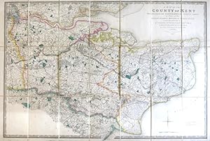
A Map of the County of Kent Drawn from the Topographical Survey Taken, by Order of the Honourable Board of Ordnance, . Reduced from the Large Map in Four Sheets by a Scale of One Inch to Two Statute Miles
Published by London: Jas. Wyld, 1841
Seller: Bow Windows Bookshop (ABA, ILAB), Lewes, United Kingdom
Association Member: ABA ILAB PBFA
Seller rating 5 out of 5 stars
Map
Map dimensions 59.5 x 89 cm, overall 63.5 x 94.5 cm. Finely engraved folding map of the county, dissected into twenty-four sections and mounted on linen, green silk trim to the edges, marbled paper to the folded end sections, folds into original green embossed cloth slipcase with Wyld's printed label to upper board and brief title label to one spine. Some mild wear to the corners of the case, a lovely example overall. Kent was the first of the Ordnance Survey maps to be published, appearing in 1801. This version, reduced in format and scale, was first published by Faden in 1807 and then by his successors, the Wylds, at intervals through to the mid-19th century.
-
Ordnance Survey of England and Wales, and Part of Scotland.
Published by Henry James, c1870]., [London,, 1870
Seller: Daniel Crouch Rare Books Ltd, London, United Kingdom
Association Member: ABA ILAB PBFA
Seller rating 4 out of 5 stars
Map
Complete set of the Ordnance Survey of England and Wales in a fine presentation box 111 hand-coloured engraved maps (including index map) printed in electrotype at the Ordnance Survey Office, each dissected and mounted on linen, with numbered vellum tabs, preserved in purpose-made wooden map chest, lettered on front 'Ordnance Maps of England'. Dimensions: chest: 1100L x 410H x 340D mm (43 x 16 x 13 in); each map (approximately): 680 x 980mm (26.75 by 38.5 in). The traditional foundation date for the Ordnance Survey has often been taken as the 21st of June 1791, when the Third Duke of Richmond, then Master-General of the Ordnance, authorised the purchase, with state funds, of a giant theodolite for �373.70. However, many writers have looked further back to such projects as the military survey of Scotland, which was executed between 1747-1755, and was the first major land survey carried out by the state. One of its surveyors, William Roy (1726-1790), would go on to make proposals in 1763, 1766, and 1783 for an official survey of Great Britain upon a scale of one inch or one and a quarter inches to the mile, however, the cost was seen to be exorbitant. However, Roy was involved in the conception of the Ordnance Survey, when in 1783 the Royal Societies of Paris and London agreed to connect their two great cities by the use of triangulation and so settle the dispute of their relative positions. The English team, headed by Roy, measured a five mile baseline on Hounslow Heath, the start and end of the line of which are commemorated by two upturned cannons. The triangulation, which was completed by 1790, together with the outbreak of war with France in 1793, acted as a catalyst for the surveying of England. Lieutenant Colonel Edward Williams was chosen to direct the works, ably assisted by William Mudge, and Isaac Dolby. They began their work in Kent and by the end of the Napoleonic Wars, in 1815, the majority of southern England had been mapped. In 1820 Captain Thomas Colby (1784-1852) was put in charge of the survey. It soon became apparent that much of the early surveying work was of insufficient standard. As a result, he ordered the revising of much of the existing survey work, which would take the next 13 years to complete. By 1844, publication of the Old Series, one inch to one mile, was complete for the whole of Britain south of Preston and Hull. The survey now became mired in what would become known as the 'Battle of the Scales'. The origin of the debate was borne from the fact that the survey of Ireland, began in the 1820s, was upon a much larger scale of 6 inches to the mile. Many suggested the scale be adopted for northern Britain and Scotland, however, when the larger scale was taken up the progress was painfully slow, and by 1851 only Lancashire and Wigtowshire had been surveyed. This led to a House of Commons Select Committee to suggest the abandonment of the scale; a suggestion that the parsimonious Treasury readily accepted. Even so this did not settle the matter and the debate would rage on for some years to come. The set was published around 1870, by which time the whole of England and Wales had been mapped. The maps are all upon a scale of one inch to one mile, and are here housed within a custom-made box, with each of the maps having numbered vellum tags. Oliver, Dr. Richard, 'A Short History of the Ordnance Survey of Great Britain', The Charles Close Society. each sheet approximately 680 by 980mm (26.75 by 38.5 inches).

![Seller image for Map of Surrey [folded] for sale by Gwyn Tudur Davies](https://pictures.abebooks.com/inventory/md/md31065775291.jpg)

![Seller image for Ordnance Survey Map of England and Wales, Sheet No. 34 One inch to One Mile [Wiltshire, Wales, Gloucestershire etc] for sale by Keoghs Books](https://pictures.abebooks.com/inventory/md/md30998042851.jpg)