Map California (136 results)

Published by Coast Geological Society, California, Folded Sheet. 1976
- Map
Seller: Eryops Books, Stephenville, U.S.A.Eryops Books
Contact seller5-star sellerLarge folded tectonic/structural map; ex-corporate library; minor shelfwear; o/w in very good condition. Map.
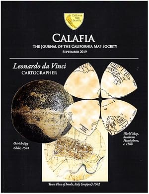
Published by California Map Society 2019
- Softcover
Seller: Diatrope Books, Berkeley, U.S.A.Diatrope Books
Contact seller5-star sellerCondition: Used - Very good
£ 11.84
£ 5.58 shippingShips within U.S.A.Quantity: 1 available
Add to basketPaperback. Condition: Very Good. Unmarked. Beautifully illustrated. Features Leonardo da Vinci's World Map by Christopher Tyler, A Map Colorist's Tale by Dorothy Raphaely, Maps of the American Colonial Frontier by Ken Habeeb, and more. 51p.
Published by A REPORT TO THE STATE WATER QUALITY CONTROL BOARD, CALIFORNIA,
- Softcover
Seller: Terrace Horticultural Books, St. Paul, U.S.A.Terrace Horticultural Books
Contact seller3-star sellerCondition: Used - Very good
£ 15.34
£ 5.20 shippingShips within U.S.A.Quantity: 1 available
Add to basketPaperback. Condition: VERY GOOD. PUBLICATION NO.34. Copyright Date: 1967 Quarto, , PP.188, COVER MARKED COMPLIMENTS K. M. STEWART, DANIEL JACKSONS COPY; PRESENTATION LETTER FROM THE UNIVERSITY OF WISCONSIN WATER RESOURCES CENTER, DIRECTOR ROHLICH. EXTENSIVE BIBLIOGRAPHY, MAP OF CALIFORNIA (illustrator).
Published by CALIFORNIA Department of Public Works; H. M. Gousha Company., * * * * * 1966
- Softcover
- Map
Seller: L. Michael, North Hollywood, U.S.A.L. Michael
Contact seller4-star sellerCondition: Used - Very good
£ 15.95
£ 8.90 shippingShips within U.S.A.Quantity: 1 available
Add to basketSoft cover. Condition: Very Good. Map: Very Good/, $54.53 CALIFORNIA OFFICIAL HIGHWAY MAP, 1966 CALIFORNIA Department of Public Works. CALIFORNIA Department of Public Works; H. M. Gousha Company. 1966 Folding Road Map Of California, 1965, In: Very Good/, Condition, Child`s Scribbling Graffiti On Covers. Description Applies To Th…is Map, ONLY. This Map Is Hard To Find, Will Be Packaged And Shipped Carefully, To Avoid Shipping Damage And Will Make It, An Excellent Addition To Your Own Personal Library Collection, Or As A Gift. WORLD WIDE SHIPPING, AVAILABLE. H. M. Gousha Company. 1966 Map: Very Good/, (illustrator).
 More images
Seller: K Books Ltd ABA ILAB, York, United KingdomK Books Ltd ABA ILAB
Contact seller5-star sellerCondition: Used - Very good
£ 10.00
£ 19.50 shippingShips from United Kingdom to U.S.A.Quantity: 1 available
No Binding. Condition: Very Good. Large coloured folding map with glossy cover, plus small booklet on Cities and National Parks (31pp), in very good condition, Hallwag, circa 2011.
Automobile Road Map: State of Washington and Southern British Columbia
Route and Map Service Department, Automobile Club of Southern California
Language: English
Published by Automobile Club of Southern California?, Los Angeles, CA?
Seller: Barry Cassidy Rare Books, Sacramento, U.S.A.Barry Cassidy Rare Books
Contact seller5-star sellerCondition: Used - Very good
£ 28.76
£ 4.47 shippingShips within U.S.A.Quantity: 1 available
Add to basketNo Binding. Condition: Very Good. Original black-and-white folding map printed on light beige paper in black ink. No date, circa 1930s. 38" x 32 1/2" unfolded. 4 1/2" x 9 1/2" folded. Map is clean and intact overall but is relatively fragile and has light age toning and holes at the seams where fold lines intersect (minimal loss… of map illustration and text at these holes). A Very Good copy. This is a road map for Washington state and Southern British Columbia. Major roads, cities and towns, political boundaries, natural features, and other geographical features are depicted on the map.
Published by Tourist Association of Central California, 525 Market St., [1915]., San Francisco: 1915
- Softcover
- First Edition
Seller: Zephyr Used & Rare Books, Vancouver, U.S.A.Zephyr Used & Rare Books
Contact seller5-star sellerOblong folio (24.5 x 9 in.). Map broadside which folds into 5 panels, double-sided, large green colour tinted map of the Exposition grounds, tinted photos of California attractions (minor dustsoiling, shelfwear, 1 very small closed tear), VG copy. First edition of this promotional brochure map promoting the surrounding tourist s…pots adjunct to the Panama-Pacific Exposition in San Francisco, including visits to San Jose, Monterey, Carmel, San Mateo, Oakland, Berkeley, Mt. Tamalpais, Muir Woods, Napa Valley, and more.
Language: English
Published by California Map Society 1992
- Softcover
Seller: Frank J. Raucci, Bookseller, Wallingford, U.S.A.Frank J. Raucci, Bookseller
Contact seller5-star sellerPaperback. Condition: Fine. Dust Jacket Condition: No Jacket, as Issued. Staple-bound Stiff Wraps, Paperback. "A Facsimile Reprint of the First Cartobibliography of the Printed Maps of California". A FINE, like-new, bright, clean, tight copy sans flaws. 33 pages. From the Foreword of Alfred W. Newman: " The cartobibliographic fa…csimile reproduced herein was the first listing of printed maps of California. It was compiled by a talented, dedicated, and indefatigable man, Joseph Cummings Rowell. The details of its thirty- three pages remain a useful tool for those interested in both the history and the political cartography of the state". LPBS.
Published by California Map Co., Los Angeles, CA 1945
- Softcover
Seller: The Calico Cat Bookshop, Ventura, U.S.A.The Calico Cat Bookshop
Contact seller5-star sellerSoft cover. Condition: Fair. Spiral bound with detached front cover. Shipped from the Calico Cat Bookshop, a brick and mortar bookshop established in 1975. Size: Octavo. Book.
Language: English
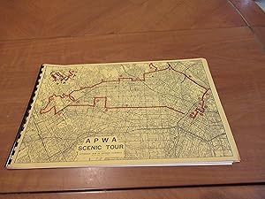
Published by American Public Works Association / Apwa, Los Angeles Ca 1965
- Softcover
- First Edition
Seller: Arroyo Seco Books, Pasadena, Member IOBA, Pasadena, U.S.A.Arroyo Seco Books, Pasadena, Member IOBA
Contact seller4-star sellerCondition: Used - Near fine
£ 118.48
£ 5.96 shippingShips within U.S.A.Quantity: 1 available
Add to basketSoft cover. Condition: Near Fine. 1st Edition. 10 Pp, In Large Oblong Yellow Wrappers With Plastic Comb Binding. Fine. A Tour-Guide Description Of Los Angeles North Of Wilshire And South Of The Hills, Largely In Terms Of Real Estate Values Emphasizing Their Rapid Increases. The Watts Riots, Sometimes Referred To As The Watts Reb…ellion Or Watts Uprising, Took Place In The Watts Neighborhood And Its Surrounding Areas Of Los Angeles From August 11 To 16, 1965.
Published by Automobile Club of Southern California (1932), Los Angeles 1932
Seller: Nat DesMarais Rare Books, ABAA, Portland, U.S.A.Nat DesMarais Rare Books, ABAA
Contact seller4-star sellerOriginal ACSC folding map printed on one side only but for the title panel. 35 x 9 1/2 inches. Very good.
Published by Forest Service, Washington, DC 1931
Seller: Nat DesMarais Rare Books, ABAA, Portland, U.S.A.Nat DesMarais Rare Books, ABAA
Contact seller4-star sellerFirst edition. Large folding map (28 x 29 inches). One side comprised of 21 panels of text and including 14 photographic illustrations by Frasher, Valentine and Willard. The map on the other side is not a topographic map but rather an administrative one showing roads, camps, trails ranger offices, etc. Some small splits at inter…stices but overall very good.An intriguing map for a no longer extant national forest: On July 1, 1945 the entire forest was divided between Inyo and Toiyabe and the name was discontinued.
Del Mar Turf Club: get on your horse and come to the Del Mar Turf Club -- July 11-Sept. 3 "Where the turf meets the surf."
[CALIFORNIA -- PICTORIAL MAP]. CROSBY, Bing (Pres.) & O'BRIEN, Pat (Vice-Pres.).
Published by Del Mar Turf Club, [Frye & Smith],, [San Diego, CA]: 1945
- Softcover
- First Edition
Seller: Zephyr Used & Rare Books, Vancouver, U.S.A.Zephyr Used & Rare Books
Contact seller5-star seller12mo. [6 pp (unpaginated).] triptych which opens into 10.5 x 6.5 in pictorial map, printed in blue & black, self-printed softcovers, front cover art of Bing & Pat on the phone, map on back cover, w/ small annotation in ink indicating "My Home" pointing at Encinitas, CA. First edition, thus, of this delightful pictorial map/broch…ure celebrating the Summer racing season at the beautiful Del Mar Turf Club horse track as World War II drew to a close. Found in 1937 by many Hollywood stars in partnership, but headed by Bing Crosby & Pat O'Brien who were ardent horse racing enthusiasts, and drew tremendous attention to the racetrack, considered one of the best in the country. The 1938 Seabiscuit and Ligaroti match race had raised tremendous awareness and interest in the racetrack, and was largely closed and repurposed for use as a B-17 tail assembly plant, however, this brochure touts their return in 1945. Worldcat locates 1 copy (UCSD).
 More images
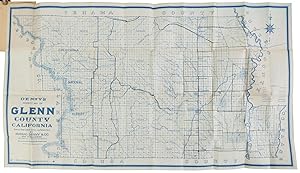
DENNY'S POCKET MAP OF GLENN COUNTY CALIFORNIA SHOWING WAGON ROADS, RAILROADS, TRAILS, ETC. COMPILED FROM LATEST OFFICIAL AND PRIVATE DATA. Published and for sale by Edward Denny & Co., Map Publishers[,] 1132 Shotwell St., San Francisco, Cal. [cover title]
(California; Glenn County) Denny & Co., Map Publishers, Edward
Published by Edward Denny & Co, San Francisco, Cal. 1913
- Softcover
Seller: Currey, L.W. Inc. ABAA/ILAB, Elizabethtown, U.S.A.Currey, L.W. Inc. ABAA/ILAB
Contact seller4-star sellerSingle sheet, 51x92 cm (20 x 36 1/4 inches), folded into white wrappers printed in black. Pocket map, printed in blue ink, showing Glenn County, California, divided into townships, and showing wagon roads, railroads, forests, creeks, canals and the Sacramento Valley Irrigation System. Old label of W. F. Purnell, Stationer & Book…seller, Sacramento, affixed over imprint on front cover. 50¢ price rubber-stamped on front cover. The map is tanned on outer panels from interaction with card covers, else nearly fine. OCLC reports 2 copies, one with cover discarded. (#169107).
MAP OF THE CITY OF FRESNO COMPILED AND PUBLISHED BY PROGRESSIVE MAP SERVICE (DAN W CHAMBERLIN) ENGINEERS, DESIGNERS[,] MAP PUBLISHERS[.] FRESNO - CALIFORNIA
(California; Fresno County) Progressive Map Service [aka Progressive Map Co.]
Published by Progressive Map Service, Fresno, California 1916
- Softcover
Seller: Currey, L.W. Inc. ABAA/ILAB, Elizabethtown, U.S.A.Currey, L.W. Inc. ABAA/ILAB
Contact seller4-star sellerBlue line map, 42x51 cm (16 1/2 x 20 inches), folded into original brown wrappers printed in black. Cover title reads "Map of Fresno City[.] Paved highways[,] roads, railroads, electric lines[,] cities, towns, streams, lakes, sections[,] townships and other information[.] Issued by Progressive Map Service (Dan W Chamberlin) Engi…neers - Designers Map Publishers Fresno - California price 50 cents." Dan W. Chamberlin was a civil engineer, a member of the California State Highway Commission, and later an assistant to Chris P. Jensen, Fresno County Surveyor and Chief Highway Engineer. Several short closed tears along folds at intersections with small tape mends. Several creases to wrappers, mainly corners, mild soiling to front panel. Very good overall. (#169063).
Hayward Home Farm Tract Subdivision No. 1, being a portion of Rancho San Lorenzo situated in the Township of Eden, County of Alameda, State of California. . . .
[CALIFORNIA -- HAYWARD HOME FARM MAP]. ANNIS, Jerome W. (Surveyor).
Published by Stocks & Holland Abstract Co., Dec. 28, 1914., Eden, CA: 1914
Seller: Zephyr Used & Rare Books, Vancouver, U.S.A.Zephyr Used & Rare Books
Contact seller5-star sellerOne oblong atlas folio map sized 25 x 14.75 in., copy requested by order of the Superior Coart of Alameda County, on silver gelatin paper (fold creases, edgewear, 1 tract coloured in on Park Side Drive (minor thumbing, edgewear, some rubbing), still VG. Early camera ready copy of the Hayward Home Farm Tract Subdivision No. 1 pre…pared in Dec., 1914 to record the plats of Hamilton, Heimann, Wooley, and Cook, on Park Side Drive at the edge of the real estate development. Eden Township created from the Rancho San Lorenzo, and Rancho San Leandro, included the present-day cities of Hayward and San Leandro. No copies in Worldcat.

Published by Rand McNally and Co. [ca. 1920], Chicago 1920
Seller: Nat DesMarais Rare Books, ABAA, Portland, U.S.A.Nat DesMarais Rare Books, ABAA
Contact seller4-star sellerFirst of this edition. With two maps on both sides of single sheet, "The Rand McNally New Commercial Atlas Map of California" in full color, & "California Automobile Road Map" with roads printed in red. 36 3/4 x 31 inches. Folding into folder measuring 4 x 6 1/2 inches. Booklet with 90, [10, ads] pp. of text, printed wrappers. S…carce commercial and road map of California. Light wear to wrappers; light wear on verso of map from being stuck to last page. A very good copy.
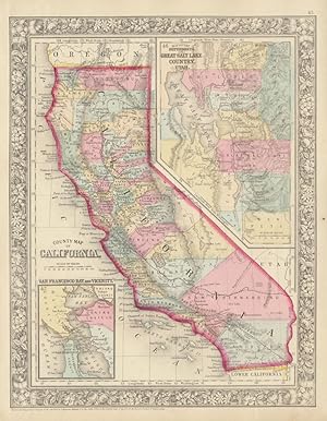
Published by S. Augustus Mitchell, Jr., New York 1860
- Map
Seller: Main Street Fine Books & Mss, ABAA, Galena, U.S.A.Main Street Fine Books & Mss, ABAA
Contact seller5-star sellerFolio (12" X 15¼", image area 10½" X 13½"). Hand colored. Very good. Light age toning. Bold, bright map of the 31st state, from the 1864 edition of "Mitchell's New General Atlas, Containing Maps of the Various Countries of the World, Plans of Cities, Etc." Small inset at lower left contains "San Francisco and Vicinity," while la…rge inset at upper right contains "Map of the Settlements in the Great Salt Lake Country, Utah." Superbly colored, with fine decorative border.
Southern California Map: Union Pacific System. . . .
[CALIFORNIA -- UNION PACIFIC MAP]. [MURRAY, W.H. (Cartographer); COLLINS, C.J. (Manager, Dept. ofTours).]
Published by Union Pacific, Poole Bros., Feb. 1, 1926]., [Chicago, IL: 1926
- First Edition
Seller: Zephyr Used & Rare Books, Vancouver, U.S.A.Zephyr Used & Rare Books
Contact seller5-star seller4to. [16 pp (unpaginated).], folded leporello accordion-style, printed in red & blue, which folds out on verso to large oblong atlas folio 32 x 18 in. Map of Los Angeles & Vicinity, inset map of California & Nevada, photo illustrations and time tables on recto, self-printed softcovers in red, white & blue w/ Union Pacific logo o…n front cover (slight shelfwear, 1 very small closed tear, slight creasting), still VG bright copy. First edition of this very scarce map of Los Angeles and environs issued by the Union Pacific Railroad during the Roaring 20's touting their famed Los Angeles Limited -- 68 hours to Chicago, and the Continental Limited which was another fast train. These two "Limited's" were outfitted with Observation Cars, Dining Cars, Tourist Cars, Drawing Room and Compartments en suite, writing, rooms, and an onboard barber and valet. No copies in Worldcat.

Official All-Year Club Sight-Seeing Map Southern California.
1953 All-Year Club Pictorial Tourist Map of Southern California
- Softcover
- Map
Seller: Geographicus Rare Antique Maps, Brooklyn, U.S.A.Geographicus Rare Antique Maps
Contact seller3-star sellerGood. Exhibits light wear along original fold lines. Unrepaired fold separations and slight loss at a few fold intersections because both recto and verso have visual merit. Text and map of Los Angeles County on verso. Size 27.5 x 22.5 Inches. This is a 1953 All-Year Club of Southern California pictorial tourist map. Coverage ext…ends from Topaz Lake south to the U.S. - Mexico border and from the Pacific Ocean to the California - Nevada border. Pictorial vignettes add charm. Tourists are illustrated sunbathing, fishing, surfing, hiking, and rock climbing, while a rancher, a covered wagon, and a miner reference the region's history. Grapes, oranges, giant sequoias, and cacti highlight the breadth of California's flora. Block texts introduce the region's eight counties, recount history, and highlight places of interest. A yellow box in the upper right includes the All-year Club's pitch that weather in southern California is ideal year-round. The All-Year Club of Southern California By the 1910s, Southern California was already a winter destination, a haven for easterners keen to escape New England winters. By the early 1920s, businessmen realized tourism need not be seasonal; Southern California's 'amazing' weather could draw visitors year-round. In 1921, a group of nineteen Southern California businessmen, led by Harry Chandler (publisher of the Los Angeles Times ), created the All-Year Club of Southern California as a spin-off of the Los Angeles Chamber of Commerce. The club lobbied the county Board of Supervisors for funding to sell southern California as a summer resort. The push began in Texas, Arizona, and Oklahoma, where residents would see L.A.'s ninety degrees days with low humidity as relief from the sweltering Midwestern summer. That year, a single large resort reported a daily increase of 100 visitors. Likewise, the Santa Fe, Southern Pacific, and Union Pacific railroads reported record ticket sales during the summer of 1921. These early successes were proof of concept for the All-Year Club, and so it expanded promotion. Numbers continued to rise, as did the Club's budget, and by 1926 the All-Year Club was spending $450,000 on advertising and promotional material. However, not everything was positive. Even though SoCal was booming, ads only wanted tourists, not job-seekers. The ads stated categorically that tourists were welcome, but job-seekers were not, since they would not be able to find work. Nonetheless, the hopeful unemployed came, leading to an ongoing population boom. The All-Year Club of Southern California operated under that name until 1968, when it became the Greater Los Angeles Visitors and Convention Bureau, which later merged with the Southern California Visitors Council. Until 2012, the organization had been known as LA Inc., and today it is the Los Angeles Tourism and Convention Board. Publication History and Census This map was created for and published by the All-Year Club of Southern California in 1953. This map is well represented in institutional collections. References: OCLC 150565292.
Map of San Leandro, California and immediate environs. . . .
[CALIFORNIA -- SAN LEANDRO LAND PROMOTION MAP]. RICHMOND, W.A. (City Manager & Engineer).
Published by San Leandro Chamber of Commerce, [1929]., San Leandro, CA: 1929
- First Edition
Seller: Zephyr Used & Rare Books, Vancouver, U.S.A.Zephyr Used & Rare Books
Contact seller5-star sellerOne oblong folio map, sized 22 x 17 in., backed w/ Railways ledger paper, manuscript annotations at fore-edge dating the office copy received Oct. 29, 1929 (dustsoiling & thumbing, some edgewear, minor creasing to a few corners), still a VG- copy. First edition of this land promotion map touting the quadrupling of post office gr…oss receipts during the Roaring 20's, the population tripling, and includes within the map the locations of the Chrysler Motor Co. factory, Fageol Motors Co. factory which was a bus builder, Caterpillar Tractor Co., and more. Map has been oriented with North in the upper left corner, and initials of MFB in lower right corner. Worldcat locates 5 copies (UC Santa Barbara, U of Chicago, Bancroft, UCLA, Cal. Hist. Soc.).

Fun Map of Nevada City California.
1950 George Mathis Pictorial Tourist Map of Nevada City, California
- Hardcover
- Map
Seller: Geographicus Rare Antique Maps, Brooklyn, U.S.A.Geographicus Rare Antique Maps
Contact seller3-star sellerGood. Light soiling. Light wear along original fold lines. Closed edge tear professionally repaired on verso. Crease to upper right corner. Size 17.25 x 22 Inches. This is a c. 1950 George Mathis pictorial map of Nevada City, California. Formerly a Gold Rush boom town, the Nevada City of today is a magnet for outdoor enthusiasts…. A Closer Look The map is centered on Nevada City. The region's outdoor recreation camps are prominently labeled, including two Girl Scout camps. Rivers, lakes, and creeks appear a bright blue, underscoring the abundant fishing opportunities. Lake Tahoe appears in the upper right corner. Fishermen appear alongside hunters (one of whom is being chased by a bear), golfers, and vacationers. References to the area's mining past appear in the form of a mining cart and prospector along the bottom edge, several abandoned mining shafts, and a runaway stagecoach on the right. Advertisements for local businesses frame the map on the left side and bottom. Publication History and Census This map was drawn by George Mathis and published by the Nevada City Chamber of Commerce c. 1950. It is dated based on Mathis's signature along the right border, which states that he lives in Nevada City. Mathis did not move to Nevada City until 1948, making 1950 the earliest likely publication date. We note a single example cataloged in OCLC, located at the California Historical Society. Scarce to the market. References: OCLC 1009086589.
 More images
Outdoor play places of California : a cartographic map of some of the outstanding recreational areas of the Golden State.
1954 Automobile Club Map of California 'Outdoor Play Places'
- Softcover
- Map
Seller: Geographicus Rare Antique Maps, Brooklyn, U.S.A.Geographicus Rare Antique Maps
Contact seller4-star sellerGood. Wear and toning along fold lines, with reinforcements and repairs on verso. Size 45.75 x 31.75 Inches. A distinctive work of mid-century Californiana and Americana, this large-format map was issued in 1954 by the Automobile Club of Southern California in its publication Westways . Displaying the entire Golden State, it loc…ates federal and state park lands, along with designated areas for fishing, hunting, skiing, and boating. A Closer Look The state of California is depicted in brilliant color, with national parks, forests, monuments, and recreation areas colored light green, dark green, or orange, highlighting their large share of California's total land. These sites, in addition to state parks, recreation areas, and areas set aside for skiing, hunting, boating, and fishing, more than 300 sites in all, are also labelled with numbers corresponding to an index surrounding the map. A legend explains additional symbols employed. Cities and highways are also noted, clarifying the ease with which these sites could be reached from major metropolitan areas. Illustrations at top and below the title cartouche are sure to include women, and children, in the idealized outdoor activities, reflecting the values (and marketing strategy) of the Automobile Club. Publication History and Census This map appeared with the December 1954 issue of Westways magazine, published by the Automobile Club of Southern California. It was designed by Lowell Butler, with descriptive notes by William Webb and Phil Townsend Hanna, drawings by Ken Sawyer, and coloring by Harry O. Diamond. As noted on the verso, the map took nearly a year to prepare, including extensive research on sites and their regulations. It is noted among the holdings of 19 institutions in the OCLC, and additionally is held by the Huntington Library and the David Rumsey Historical Map Collection. References: Rumsey 6835.002. OCLC 876789359.
Published by Oakland Tribune,, Oakland, CA: 1931
- First Edition
Seller: Zephyr Used & Rare Books, Vancouver, U.S.A.Zephyr Used & Rare Books
Contact seller5-star sellerOne Elephant folio map, sized 22 x 34 in., printed on blue-tinted paper stock, w/ scale of 1:1,520,000, and includes 6 different inset maps, fold creases (minor dustsoiling, thumbing), still VG bright copy. First edition, thus, of this well-executed and scarce automobile travel map issued by the Oakland Tribune at the onset of t…he Great Depression, with specific mileage tables for traveling on U.S. Highways 99W, 99E, 99, 40, & 101, with distances calculated from Oakland. Inset maps include Eastbay & Vicinity, Sacramento, Fresno, Santa Clara & San Jose, Bakersfield, and Stockton, CA. This automobile motoring map adapted and enhanced the 1923 and 1927 Oakland Tribune maps. Worldcat locates 2 copies (CA Hist. Soc., Bancroft).
 More images
Discovery and Sightseeing Map Los Angeles City and County for Service Men and Women.
1945 All Year Club of Southern California Map of Los Angeles City and County, California
- Softcover
- Map
Seller: Geographicus Rare Antique Maps, Brooklyn, U.S.A.Geographicus Rare Antique Maps
Contact seller4-star sellerVery good. Exhibits wear along original fold lines. Exhibits slight loss at a handful of fold intersections. Maps of Los Angeles, Long Beach, Santa Monica Bay, and the San Gabriel Valley on verso. Size 21.75 x 33.5 Inches. This is a 1945 All-Year Club of Southern California map of Los Angeles. Created for American servicemen and… women during World War II, the map highlights U.S.O. clubs, Y.M.C.A.s, Y.W.C.A.s, and Red Cross facilities. Tourist sites throughout are identified. On the county map, which occupies the recto, sites from Joshua Forest west to the coast are highlighted, including parks, universities, the Rose Bowl (for college football fans), and a chinchilla farm. The smaller map on the recto, which occupies the lower right corner, focuses on the immediate environs of Los Angeles, illustrating the road network. Verso Content Four inset maps occupy the verso and detail the Santa Monica Bay, San Gabriel Valley, Long Beach, and the city of Los Angeles. Sites are labeled throughout all four maps. However, the map of Los Angeles is by far the most charming, using pictorial vignettes to highlight the city's sites. Theatres, movie studios, parks, and museums benefit from this treatment. The All-Year Club of Southern California By the 1910s, Southern California was already a winter destination, a haven for easterners keen to escape New England winters. By the early 1920s, businessmen realized tourism need not be seasonal; Southern California's 'amazing' weather could draw visitors year-round. In 1921, a group of nineteen Southern California businessmen, led by Harry Chandler (the publisher of the Los Angeles Times ), created the All-Year Club of Southern California as a spin-off of the Los Angeles Chamber of Commerce. The club lobbied the county Board of Supervisors for funding to sell southern California as a summer resort. The push began in Texas, Arizona, and Oklahoma, where residents would see L.A.'s ninety degrees days with low humidity as relief from the sweltering Midwestern summer. That year, a single large resort reported a daily increase of 100 visitors. Likewise, the Santa Fe, Southern Pacific, and Union Pacific railroads reported record ticket sales during the summer of 1921. These early successes were proof of concept for the All-Year Club, and so it expanded promotion. Numbers continued to rise, as did the Club's budget, and by 1926 the All-Year Club was spending $450,000 on advertising and promotional material. However, not everything was positive. Even though SoCal was booming, ads called only tourists, not job-seekers. The ads stated categorically that tourists were welcome, but job-seekers were not, since they would not be able to find work. Nonetheless, the hopeful unemployed came, leading to an ongoing population boom. The All-Year Club of Southern California operated under that name until 1968, when it became the Greater Los Angeles Visitors and Convention Bureau, which later merged with the Southern California Visitors Council. Until 2012, the organization had been known as LA Inc., and today it is the Los Angeles Tourism and Convention Board. Publication History and Census This map was created for and published by the All-Year Club of Southern California in 1945. We note two examples cataloged in OCLC which are part of the collections at the California Historical Society and Stanford University. We are aware of 1944 and 1945 editions. It is possible that editions were published prior to 1944 as well. Examples of this map (in various editions) appear on the private market from time to time. References: OCLC 950013862.

Published by Schmidt Litho Co., San Francisco 1928
Seller: Nat DesMarais Rare Books, ABAA, Portland, U.S.A.Nat DesMarais Rare Books, ABAA
Contact seller4-star sellerThis 1928 version of the Official Map of Colusa County is an updated edition of the original 1891 map (also done by Felknor). 58 1/2 x 40 inches. linen-backed. Very good condition. OCLC only locates 4 copies.A useful reference as it give the names of the property owners. Coulsa Counthy, then as now, is chiefly known for its rice… and almond production. The county was named after the 1844 Rancho Colus Mexican land grant to John Bidwell. With a total population of only about 22,000 it is sparsely populated. It is quite familiar to those who drive the I-5 and through the towns of Arbunkle, Grimes, Maxwell and Williams.
 More images
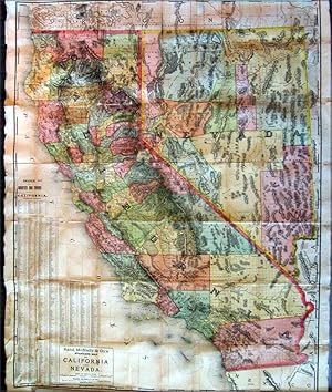
Published by Rand, McNally, & Co., Chicago 1887 1887
Seller: DR Fine Arts, New York, U.S.A.DR Fine Arts
Contact seller5-star sellerNo Binding. Condition: Good. (MAP by Rand, McNally); colored map of California & Nevada dated 1887 (an a small southern part of Oregon); Title of Map "Rand, McNally & Co's standard map of California And Nevada"; stated on the map at bottom in tiny text "Copyright, 1887, by Rand, McNally, & Co., Chicago"; paper size: 35 x 44 in;…with and Index the left titled: "INDEX TO COUNTRIES & TOWNS IN CALIFORNIA"; the map is complete & the colors are still somewhat bright; but most of the backs folded sections have been repaired and are held together with old tape and with some recent Archivals Transparent Mending Tissue but would need a lot repairs to the back to permanently preserve this this early map of the California & Nevada; small tears and crease to the left edges; the image of the map is in GOOD COND.
Published by made under the direction of the Hon. Jefferson Davis, Secretary of War by Lieut. R.S. Williamson, Topogl. Engr. assisted by Lieut. J.G. Parke, Topl. Engr. and Mr. Isaac Williams Smith, Civ. Engr. 1853 1853
Seller: Up-Country Letters, Gardnerville, U.S.A.Up-Country Letters
Contact seller2-star sellermade under the direction of the Hon. Jefferson Davis, Secretary of War by Lieut. R.S. Williamson, Topogl. Engr. assisted by Lieut. J.G. Parke, Topl. Engr. and Mr. Isaac Williams Smith, Civ. Engr. 1853. One of a series of surveys meant to Ascertain the Most Practicable and Economical Route for a Railroad From the Mississippi Rive…r to the Pacific Ocean . A north/south view of California from the San Francisco Bay to San Diego. The railway line is shown extending as far east as Fort Yuma. Removed from a larger publication - Reports of Explorations and Surveys, to Ascertain the Most Practicable and Economical Route for a Railroad From the Mississippi River to the Pacific Ocean. Made Under the Direction of the Secretary of War, In 1853-56, According to Acts of Congress of March 3, 1853, May 31, 1854, and August 5, 1854. Volume XI. Washington: George W. Bowman, Printer. 1861. 36th Congress, 2d Session, Senate, Ex. Doc. (The above information taken from the description of this map in the David Rumsey Map Collection, Stanford University). Folded to 7 x 11 inches for insertion in the above volume, 73 x 26 inches spread out. Some toning at some edges and folds, some folds tender or beginning to separate, in Very Good condition.
Published by San Francisco-Oakland Terminal Railways Co., Maintenance of Way & Buildings Dept., April 1, 1912., Oakland, CA: 1912
- First Edition
Seller: Zephyr Used & Rare Books, Vancouver, U.S.A.Zephyr Used & Rare Books
Contact seller5-star sellerOne oblong elephant folio map, sized 36.5 x 12 in., w/ woodcut-engraved border, with minor creasing & soiling, some rubbing, and edgewear, a few old closed tears, neatly repaired on verso, still a VG- copy. First edition of this exceptionally scarce map demarcating the extent of the S.F.O.T. Railways Co. upon its formation in 19…12 had after the merger of the Key System, East Shore & Suburban Railway, and the Oakland Traction Co. by the three main competitors to the Southern Pacific commuter ferry market, who also established their own ferry system, and substantially expanded their new streetcar line suburbs across the East Bay. The map depicts their growth and reach from Hawayrd to Richmond, CA, with stops in Albany, Berkeley, Piedmont, Oakland, Alameda, San Leandro, and San Lorenzo in between. Also depicted are the railroad lines of the Southern Pacific, Santa Fe, Western Pacific, Oakland & Antioch Railway, and Richmond Belt Line Railway. In 1932 the conversion to motorized buses began on August 1, when the East Richmond/23rd Street line was entirely changed over. They were then steadily converted until No., 1933, when the S.F.O.T. Railways streetcars made their last runs. No copies in Worldcat. See: San Francisco-Oakland Terminal Railways: Bond History and Sinking Fund Requirements (1915); Plan of Reorganization (1922).
Published by Published by H.A. Candrian, Edward P. Taylor, Importer & Dealer in Books and Stationery, [ca. 1926]., [San Francisco] & Oakland, CA: 1926
- First Edition
Seller: Zephyr Used & Rare Books, Vancouver, U.S.A.Zephyr Used & Rare Books
Contact seller5-star sellerTwo parts. 1st - One double-sided atlas folio map. 28 x 22 in., featuring Candrian's wood plank logo displaying Oakland, Alameda, and Piedmont, w/ inset map of San Leandro, neatline borders, and map of City of Richmond inset on verso (fold creases as issued, some thumbing, edgewear, couple closed tears, 1 central closed tear at…crease fold), still G- copy; 2nd - 12mo. 3.4 x 7.4 in. 96 pp. With 12 pp. of maps and Car-o-Gram glyphs graphically representing streetcar lines in the East Bay, with sepia-tinted photo illustrations. Green-tinted and printed softcovers, rounded corners (minor sunning to lower fore-edges), still a VG copy. First editions, thus, of this very scarce pair, including the detailed map of Oakland, Alameda, Berkeley, Piedmont, San Leandro, and Richmond, CA detailing the public buildings, parks, city streets, and more specifically the trolley and streetcar lines across and connecting the East Bay, along with Candrian's innovative Car-o-Gram guidebook. The City of Richmond map includes not only the city boundary line, but also connecting railroads such as the Santa Fe Railroad, as well as electric streetcar lines. This version does not include the American Bank advertisements which appear in other examples as border to the City of Richmond inset map on verso. Candrian (1862-1928) was a Swiss-American entrepreneur who was the first to introduce Car-oGrams which were little glyphs making streetcar lines much more accessible, and although not the best representations, the glyphs provided vital visual information for travelers and visitors. Worldcat locates 2 copies w/ map (CA Hist. Soc. & Huntington); 2 copies of maps only (UCLA, Berlin Staatsbibliothek); See: 'Car-o-Grams:' Candrian's Early Transit Mapping Innovation, Sunnyside History Project, Sunnyside, CA (May 23, 2018).


