
Order Total (1 Item Items):
Shipping Destination:

Leboff David Tim Demuth (9 results)
Feedback
Skip to main search results
Search filters
Product Type
- All Product Types
- Books (8)
- Magazines & Periodicals (No further results match this refinement)
- Comics (No further results match this refinement)
- Sheet Music (No further results match this refinement)
- Art, Prints & Posters (No further results match this refinement)
- Photographs (No further results match this refinement)
- Maps (1)
- Manuscripts & Paper Collectibles (No further results match this refinement)
Condition Learn more
- New (No further results match this refinement)
- As New, Fine or Near Fine (1)
- Very Good or Good (5)
- Fair or Poor (No further results match this refinement)
- As Described (3)
Binding
- All Bindings
- Hardcover (8)
- Softcover (No further results match this refinement)
Collectible Attributes
- First Edition (5)
- Signed (No further results match this refinement)
- Dust Jacket (No further results match this refinement)
- Seller-Supplied Images (3)
- Not Print on Demand (9)
Language (2)
Price
- Any Price
- Under � 20
- � 20 to � 35 (No further results match this refinement)
- Over � 35 (No further results match this refinement)
Free Shipping
Seller Location
Seller Rating
-
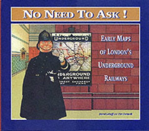
No Need to Ask! Early Maps of London's Underground Railways
Published by Capital Transport Publishing 30/11/1999, 1999
ISBN 10: 1854142151 ISBN 13: 9781854142153
Language: English
Condition: Very Good. This book is in very good condition and will be shipped within 24 hours of ordering. The cover may have some limited signs of wear but the pages are clean, intact and the spine remains undamaged. This book has clearly been well maintained and looked after thus far. Money back guarantee if you are not satisfied. See all our books here, order more than 1 book and get discounted shipping. .
-
No Need to Ask - Early Maps of London's Underground Railways
Seller: The Book House (PBFA), Northallerton, United Kingdom
Association Member: PBFA
Seller rating 5 out of 5 stars

Hardcover. Condition: Very Good. Picture boards. Landscape quarto, 80 pages, illustrated.
-

No Need to Ask! Early Maps of London's Underground Railways
Published by Capital Transport, Harrow Weald, 1999
ISBN 10: 1854142151 ISBN 13: 9781854142153
Language: English
Hardback. Condition: Very Good. Glazed pictorial boards. Landscape format. 240 x 280 mm. 80 pp. Copiously illustrated, mainly in colour. A clean, bright copy. Book.
-
No Need to Ask! Early Maps of London's Underground Railways
Published by Capital Transport Publishing, 1999
ISBN 10: 1854142151 ISBN 13: 9781854142153
Language: English
Seller: Nick Tozer Railway Books, Huddersfield, United Kingdom
Seller rating 5 out of 5 stars
First Edition
Hardcover. Condition: Very Good. 1st Edition.
-
No Need to Ask! Early Maps of London's Underground Railways
Published by Capital Transport Publishing, Great Britain, 1999
ISBN 10: 1854142151 ISBN 13: 9781854142153
Language: English
Seller: The London Bookworm, East Sussex, United Kingdom
Seller rating 5 out of 5 stars
First Edition
Hardcover. Condition: Very Good. No Jacket. First Edition. Hardcover. First Edition. No Need to Ask! Early Maps of London's Underground Railways. Small mark to back cover from removal of old label. Published in association with London Transport Museum. The Underground map has come to represent a distinctive image associated with London. The unified system of today began life as a number of separate companies, beginning with the Metropolitan Railway in 1863. Under the influence of American finance, the first groupings of companies occurred in the early years of the twentieth century and maps showing the different lines as a unified system began to appear. Before the famous Beck diagrammatic map appeared in 1933, maps of the Underground railways were produced in many different styles. Prior to co-ordination of publicity, individual companies would often show their own railway much more prominently than others, sometimes omitting 'competing' lines altogether. This book - a companion volume to Mr. Beck's Underground Map - Illustrates the development of the many attractive and unusual maps used to describe and publicise London's Underground railways before the diagrammatic approach simplified a complicated and expanding system. Illustrated throughout. 80 pp. (We carry a wide selection of titles in The Arts, Theology, History, Politics, Social and Physical Sciences. Academic and Scholarly books and Modern First Editions ,and all types of Educational Reference Literature.).
-

No Need to Ask ! Early Maps of London's Underground Railways.
Published by Harrow Weald: Capital Transport Publishing, 1999., 1999
Seller: Cornell Books Limited, Tewkesbury, United Kingdom
Association Member: PBFA
Seller rating 5 out of 5 stars
Map First Edition
Condition: Near Fine. First edition (hardback). Oblong 4to (25cm by 18cm), 80pp. Illustrated throughout in colour. Original laminated boards. This book is in very good condition. ISBN 1854142151.
-

No need to ask! : early maps of London's underground railways / David Leboff and Tim Demuth
Published by Harrow Weald, Middlesex: Capitol Transport, 1999
ISBN 10: 1854142151 ISBN 13: 9781854142153
Language: English
First Edition
� 11.53
Convert currency� 9.46 shipping from Ireland to United KingdomQuantity: 1 available
Add to basketFirst Edition. Fine copy in the original colour-printed boards. Remains particularly well-preserved overall; tight, bright, clean and strong. Literally as new. Physical description: 78 pages : illustrations (chiefly color, maps (chiefly color) ; 25 cm. Notes: Published in association with London Transport Museum. Includes bibliographical references. Subjects: London Underground Limited History. London Underground Limited. Subways England London ; Maps. Subways England London History. M�tros Angleterre Londres Histoire. London Railways ; Literature 1999. London Transport Cartography ; Literature 1999. England London. Railways. Underground railway stations. Underground railway networks. Transport. Cartography. Public transport. Maps. London : underground railways : maps. London Maps, plans and views 1870-1899. 1 Kg.
-
NO NEED TO ASK! EARLY MAPS OF LONDON'S UNDERGROUND RAILWAYS
Published by CAPITAL
Seller: Book Cupboard, PLYMOUTH, DEVON, United Kingdom
Seller rating 3 out of 5 stars

1999 1ST FINE PICTORIAL BOARDS.
-

NO NEED TO ASK! Early Maps of London's Underground Railways.
Published by Middlesex. Capital Transport Pub., 1999
Seller: The Antique Bookshop & Curios (ANZAAB), Crows Nest, NSW, Australia
Association Member: ANZAAB ILAB
Seller rating 4 out of 5 stars

First Edition
� 17.70
Convert currency� 22.10 shipping from Australia to United KingdomQuantity: 1 available
Add to basketOblong 4to. Col.ill.bds. 80pp. Profusely illustrated in colour and black & white. Very good copy. 1st ed. The Underground map has come to represent a distinctive image associated with London. Harry Beck's 1931 tube map was the first schematic tube map designed for the London Underground & has become iconic.
