Order Total (1 Item Items):
Shipping Destination:

Laurie Richard Holmes (30 results)
Skip to main search results
Search filters
Product Type
- All Product Types
- Books (19)
- Magazines & Periodicals (No further results match this refinement)
- Comics (No further results match this refinement)
- Sheet Music (No further results match this refinement)
- Art, Prints & Posters (No further results match this refinement)
- Photographs (No further results match this refinement)
- Maps (11)
- Manuscripts & Paper Collectibles (No further results match this refinement)
Condition Learn more
- New (13)
- As New, Fine or Near Fine (4)
- Very Good or Good (1)
- Fair or Poor (No further results match this refinement)
- As Described (12)
Binding
Collectible Attributes
- First Edition (2)
- Signed (No further results match this refinement)
- Dust Jacket (No further results match this refinement)
- Seller-Supplied Images (16)
- Not Print on Demand (24)
Language (2)
Free Shipping
Seller Location
Seller Rating
-

PAP. Condition: New. New Book. Shipped from UK. Established seller since 2000.
-
The Art of Painting in Oil, Rendered Familiar to Every Capacity: Extracted From the Works of the Most Eminent Masters, of the Italian, Flemish, and English Schools (but Principally From Mr. Bardwell) (Classic Reprint)
Seller: PBShop.store UK, Fairford, GLOS, United Kingdom
Seller rating 5 out of 5 stars

PAP. Condition: New. New Book. Shipped from UK. Established seller since 2000.
-

HRD. Condition: New. New Book. Shipped from UK. Established seller since 2000.
-
The Art of Painting in Oil, Rendered Familiar to Every Capacity Extracted From the Works of the Most Eminent Masters, of the Italian, Flemish, and From Mr Bardwell Classic Reprint
Seller: PBShop.store UK, Fairford, GLOS, United Kingdom
Seller rating 5 out of 5 stars
HRD. Condition: New. New Book. Shipped from UK. Established seller since 2000.
-

Laurie's Sailing Directory for the Ethiopic or Southern Atlantic Ocean. Composed and arranged by J. Purdy. Fourth edition, revised and corrected by A.
Language: English
Published by British Library, Historical Print Editions, 2011
ISBN 10: 1241244766 ISBN 13: 9781241244767
Condition: New.
-

Laurie's Sailing Directory for the Ethiopic or Southern Atlantic Ocean. Composed and arranged by J. Purdy. Fourth edition, revised and corrected by A.
Language: English
Published by British Library, Historical Print Editions, 2011
ISBN 10: 1241244766 ISBN 13: 9781241244767
Condition: As New. Unread book in perfect condition.
-

Laurie's Sailing Directory for the Ethiopic or Southern Atlantic Ocean. Composed and arranged by J. Purdy. Fourth edition, revised and corrected by A. G. Findlay.
Language: English
Published by British Library, Historical Print Editions, 2011
ISBN 10: 1241244766 ISBN 13: 9781241244767
Seller: Ria Christie Collections, Uxbridge, United Kingdom
Seller rating 5 out of 5 stars
� 26.91
� 11.98 shipping
Ships from United Kingdom to U.S.A.Quantity: Over 20 available
Add to basketCondition: New. In.
-

Laurie's Sailing Directory for the Ethiopic or Southern Atlantic Ocean. Composed and arranged by J. Purdy. Fourth edition, revised and corrected by A.
Language: English
Published by British Library, Historical Print Editions, 2011
ISBN 10: 1241244766 ISBN 13: 9781241244767
Seller: GreatBookPricesUK, Woodford Green, United Kingdom
Seller rating 5 out of 5 stars
Condition: New.
-

Laurie's Sailing Directory for the Ethiopic or Southern Atlantic Ocean. Composed and arranged by J. Purdy. Fourth edition, revised and corrected by A.
Language: English
Published by British Library, Historical Print Editions, 2011
ISBN 10: 1241244766 ISBN 13: 9781241244767
Seller: GreatBookPricesUK, Woodford Green, United Kingdom
Seller rating 5 out of 5 stars
Condition: As New. Unread book in perfect condition.
-
Paperback. Condition: New. Print on Demand. This book, which will benefit artists of all skill levels, is an instructional treatise on one of the pivotal and most challenging aspects of painting: the process of using oil colors and techniques to achieve lifelike color on a canvas. The author, an established oil painter, has distilled his years of experience into a compact guide that empowers artists to apply oil-based color theory into their own work. This book delves not only into practical techniques but also into the theoretical principles and historical context of oil painting, ultimately demonstrating how a mastery of oil colors can elevate an artist's practice. This book is a reproduction of an important historical work, digitally reconstructed using state-of-the-art technology to preserve the original format. In rare cases, an imperfection in the original, such as a blemish or missing page, may be replicated in the book. print-on-demand item.
-

IRELAND [Folding Map in a slipcase]
Language: English
Published by Richard Holmes Laurie, London, 1828
Seller: THOMAS RARE BOOKS, Yaxley, SUFFOLK, United Kingdom
Seller rating 4 out of 5 stars

First Edition
No Binding. Condition: Fine. 1st Edition. A fine and very rare printed folding map of IRELAND by Richard Holmes Laurie, 53 Fleet Street, London 84 x 64 cms [33 x 25 inches] with original fine hand-colouring and enclosed in the original green calf slipcase with gilt title embossed to the case edge. Divided into 18 panels on a linen sheet. No recorded copy at auction and no copy in Copac [a similar dated 1817 in the BL] Published 8th April 1828. No copies in WorldCat. Richard Holmes Laurie [1777-1835] was the son of Robert Laurie who whom he apprenticed as a mezzotinter who went into partnership with his fathers old partner Whittle until the latters death in 1818. Laurie and Whittle were one of the leading British Cartographic publishers in the 18th and 19th century. Richard Holmes Laurie used Captain Powell's observations of Laurie Island in the South Atlantic and printed the first map of the island which was then named after him.
-
Laurie's Sailing Directory for the Ethiopic or Southern Atlantic Ocean Composed and arranged by J Purdy Fourth edition, revised and corrected by A G Findlay
Language: English
Published by British Library, Historical Print Editions, 2011
ISBN 10: 1241244766 ISBN 13: 9781241244767
PAP. Condition: New. New Book. Shipped from UK. THIS BOOK IS PRINTED ON DEMAND. Established seller since 2000.
-
Laurie's New Traveller's Companion and Guide Through the Roads of England and Wales, Including Great Part of Scotland; with a General Map and an Index
Published by Published by R. H. Laurie, London, 1830
Seller: Keoghs Books, Skipton, United Kingdom
Association Member: PBFA
Seller rating 5 out of 5 stars
Map
, [ii], 6, complete with 26 double-page maps, hand-coloured in outline, including 1 folding map of England, index to the Cities, Boroughs, Market-Towns, and Principal Villages in England and Wales at the front Improved Edition , covers rubbed and with a few small marks, tear at upper front joint and hinges weakened, some light brown offsetting to maps but generally nice and clean, in good condition , plum roan leather covers, marbled endpapers 27 x 17 cm Hardback ISBN:
-
Laurie's Sailing Directory for the Ethiopic or Southern Atlantic Ocean Composed and arranged by J Purdy Fourth edition, revised and corrected by A G Findlay
Language: English
Published by British Library, Historical Print Editions, 2011
ISBN 10: 1241244766 ISBN 13: 9781241244767
Seller: PBShop.store UK, Fairford, GLOS, United Kingdom
Seller rating 5 out of 5 stars
� 26.48
� 6.76 shipping
Ships from United Kingdom to U.S.A.Quantity: Over 20 available
Add to basketPAP. Condition: New. New Book. Delivered from our UK warehouse in 4 to 14 business days. THIS BOOK IS PRINTED ON DEMAND. Established seller since 2000.
-
Laurie's Sailing Directory for the Ethiopic or Southern Atlantic Ocean. Composed and arranged by J. Purdy. Fourth edition revised and corrected by A. G. Findlay.
Language: English
Published by British Library, Historical Print Editions, 2011
ISBN 10: 1241244766 ISBN 13: 9781241244767
Condition: New. Print on Demand pp. 628.
-
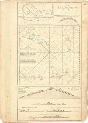
The Cape Verd Islands, laid down from the Remarks and Observations of Experienced Navigators, by Monsr. d'Apres de Mannevillete, with several Additions.
Published by LondonLaurie & Whittle 12th May ., 1794
Seller: Robert Frew Ltd. ABA ILAB, London, United Kingdom
Association Member: ABA ILAB PBFA
Seller rating 5 out of 5 stars
Map
Original uncoloured engraved map of the Cape Verde islands. Map dimensions 52 x 28.5 cm, overall sheet dimensions 54 x 38.5 cm. A bit toned overall and with some smudging to marings. A finely detailed chart of the Cape Verde Islands off the Coast of Africa, which appeared in a later edition of the West India Atlas. This sheet of sea charts details the Cape Verde Islands. First settled by the Portuguese in 1462, it soon became a popular haunt for pirates, including Sir Francis Drake in the 1580s. The sheet features with inset maps of Praya Bay, A View of the English Road, A View of Praya Bay and a group of recognition views. Sayer and Bennet based their work on charts by Jean-Baptiste Mannevillettes's Le Neptune Oriental (Paris, 1745).
-

The Russian Dominions in Europe
Published by London, 1820
Seller: Clive A. Burden Ltd., Chalfont St. Giles, BUCKS, United Kingdom
Seller rating 5 out of 5 stars
Map
No binding. 785 x 610 mm., in fine early wash colour. Good paper in fine condition. A nice attractive large scaled map of European Russia.
-
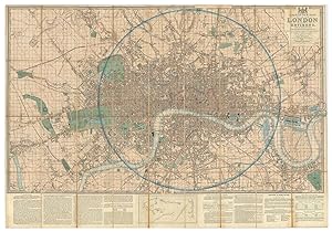
SURVEY OF THE COUNTRY AROUND LONDON TO THE DISTANCE OF THIRTY-TWO MILES FROM ST. PAUL'S. [SOLD BY LETTS].
Published by Rd. H. Laurie, No. 53 Fleet Street, London., London., 1879
Seller: Marrins Bookshop, Folkestone, KENT, United Kingdom
Association Member: ABA ILAB PBFA
Seller rating 4 out of 5 stars
Condition: How 321 (9). Large, hand-coloured folding map, dissected and laid on to linen, 30.5 X 23 inches, extending from Bray to Chatham and Ware to Dorking. The Laurie imprint to the lower margin has a printed paper label overlaying it reading 'Letts, Son & Co. Limited, London. Agents by Appointment for the Sale of Ordnance and Geological Survey Maps. General Mapsellers and Publishers.' Preserved in the edgeworn original blind-embossed cloth-covered boards, Letts title vignette gilt with remains of paper label 'Envir[ons of London]. Letts labels to inside front board and map end fold, and bookplate of Col. Edwin Hughes, M.P. on pastedown label. Slight wear to linen at intersections but the map is in very good condition, with still-vibrant colour.
-
Whittle and Laurie's A New Survey of the Environs of London Extending Twenty Miles North and South from the Parallel of St Paul's and Twenty Six Miles East and West from the Meridian of the same Place
Published by Whittle and Laurie, 1828
Seller: Morning Mist Books and Maps, Cirencester, United Kingdom
Seller rating 5 out of 5 stars
Map
No Binding. Condition: Very Good. An attractive folding map with corresponding slipcase. Outline colouring to county borders; parks in green; roads in light brown. Printing clear. General dust-marking and a little spotting. Wear to edges. A few holes at fold junctions. General dust-marking and discolouring to reverse: nothing major. Hyde Park and Regent's Park on the outskirts of London. Paddington Canal marked. Surrey Iron Railway present. Close examination of the map reveals planned developments for an expanding city, including: proposed feeder for Regent's Canal; proposed reservoir; road straightening. Other features include a wealth of local place names, many now replaced or with different spellings; magazines around Woolwich; garrets; race ground /course etc. Date to lower margin (1st March 1828). Sheet size: 71cm by 57cm approx. Slipcase with Whittle and Laurie label to front, generally worn in all respects. Further details available on request. (non480iri).
-
New Sailing Directions to accompany the Channel Pilot and their large general chart of the English Channel, [.]. Fifth Edition.
Seller: Herman H. J. Lynge & S�n ILAB-ABF, Copenhagen, Denmark
Seller rating 4 out of 5 stars
London, printed for James Whittle and Richard Holmes Laurie, 1815. 8vo. In contemporary blue boards (original ?). Stamp to spine. Stamp and annotations in contemporary hand to title-page. Soiling and wear to extremities and brownspottet throughout. VIII, 130 pp. + folded tabel on the tides in English channel. Rare fifth edition of Whittle and Laurie's pilot to the English Channel.
-
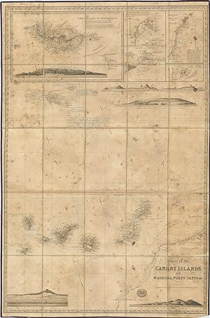
Chart of the Canary Islands, with Madeira, Porto-Santo, &c.
Published by LondonR.H. Laurie No. 53. Fleet Street June 30 ., 1842
Seller: Robert Frew Ltd. ABA ILAB, London, United Kingdom
Association Member: ABA ILAB PBFA
Seller rating 5 out of 5 stars
Map
ANNOTATED ONBOARD A CONTEMPORARY VOYAGE. Original engraved folding map (100 x 66.5 cm) depicting the Canary Islands, Madeira and part of the West Coast of Africa, incorporating five inset maps of the Islands of Madeira, the Island of Porto Santo, the Road of Funchal, the Roadstead of Santa-Cruz, and Great Salvage, together with five engraved coastal landscape profiles of Funchal and the South Madeira, Porto Santo, Allegranza, the Island of Palma, Tenerife from the South-West, and the Isleta of the Grand Canary. Copiously annotated with printed notations of settlements, landmarks, references to other maps and books, and navigational aids ("good anchorage", "strong current", "Shell fish abundant", "Pyramid, a high Rock frequently mistaken for a large Ship under sail", "Beware of approaching too near the coast hereabout, lest the Current set you aground on the Flat, and you fall, enslaved, into the hands of the Arabs"). Additionally annotated with detailed manuscript notes written in fine blue ink relating to a two-part voyage made in 1844 aboard the Brig 'Vernon' and the Schoone 'Admiral Colpoys'. A very good copy of a map which has seen active service, with old damp marking throughout and a little creasing to the bottom corners. A splendid engraved map of the Canary Islands, meticulously annotated during a contemporary voyage. Clearly used as a navigational aid, the annotations carefully chart the progress of a two-part voyage from Porto Santo, Madeira, via Funchal, to Santa Cruz, Tenerife. First describing the progress of the initial leg from Porto Santo to Madeira (31st January - 2nd February 1844) onboard the Brig 'Vernon', under Captain Webster, they go on to summarise the final leg from Funchal, Madeira to Santa Cruz, Tenerife, via the Schooner the 'Admiral Colpoys', commanded by Nathaniel Spencer: "19th October 1844. - Schooner 'Admiral Colpoys', Nathl. Spencer Commdr., from Madeira to Teneriffe. At 1 p.m. made sail at Noon on 20th Lat. 30. 33. 25 Miles Northward of the Great Salvage. At 1 p.m. Gt. Salvage S. by E. 20 miles. At 7 p.m. passed the Southern Salvage. At Daylight 21st saw the Eastend of Tenerife. At Noon East End South Distant about 4 Leagues. At 5.30 p.m. Dropped anchor in the Roadstead of Santa Cruz". Each leg of the voyage is also accurately recorded on the map using neat ruled lines in blue ink. The manuscript annotations additionally comment on the map's accuracy, mark further settlements and correct information such as population statistics, noting, for example, beside the island of South Deserta: "Population according to Wyld's Chart, 600. Incorrect. No constant residents. A few fishermen occasionally resort there for a few months in the year and scarcely amount to fifty in number". In another significant intervention, the annotator also asserts that in the map's panorama of Funchal, the "mountains [are] scarcely lofty enough in proportion to the space occupied by the town", with the mountains' summits diligently re-drawn in ink. On the inset map depicting Porto Santo, the mooring of the 'Vernon' off the island's coast is denoted by way of a small hand-drawn ship, which is also accompanied by an inland route noting the location of "water", and there is a further hand-drawn inland route on the island of Madeira, which additionally notes elevations and additional settlements/landmarks. The Canary Islands were a popular port of call for ships travelling between Europe and the Americas, with some transporting the islands' own products such as cochineal, sugarcane and rum to be sold in American ports such as Veracruz, Campeche, La Guaira and Havana. An evocative map, having seen active service aboard (at least) two contemporary voyages within the Canary Islands. Scarcity: Only one institutional copy recorded worldwide according to WorldCat (British Library).
-
Laurie's New Plan of London and its Environs, with an improved Scale for Ascertaining Distances, the Fares of Hackney Coaches, Porterage of Parcels, &c. By John Lingard.Being an Original Survey by John Outhett with all the Recent Improvements.Dedicated by Permission, to the Right Honourable Lord Viscount Melbourne.
Published by LondonRichard Holmes Laurie. No. 3 Ave Maria Lane ., 1841
Seller: Robert Frew Ltd. ABA ILAB, London, United Kingdom
Association Member: ABA ILAB PBFA
Seller rating 5 out of 5 stars
Map
Original hand-coloured engraved plan of London (76 x 110 cm) extending from Hampstead in the north to Camberwell in the south, the East India Docks in the east and Shepherds bush in the west. Dissected into 36 sections and mounted onto linen, with descriptive 'ingenious Scale and Key' beneath 'for ascertaining distances in any direction at one view'. Some slight wear along folds, generally a most attractive example. The key explains that the map was based upon a new survey by John Outhett who, as the note beneath the title explains, based the map upon the trigonometric survey by General William Roy (who inspired the original Ordnance Survey) and extended by a recent survey by Mr. Findlay. Howgego 361 (3).
-
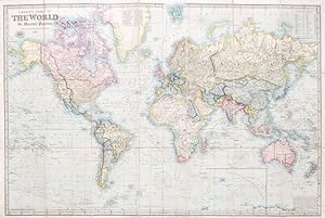
Laurie's Chart of the World on Mercator's Projection. (Reduced from the Large Chart by John Purdy)
Published by London: Richard Holmes Laurie 9th Jan., 1857, 1857
Seller: Bow Windows Bookshop (ABA, ILAB), Lewes, United Kingdom
Association Member: ABA ILAB PBFA
Seller rating 5 out of 5 stars
Map
Map dimensions 64 x 97 cm, overall 67 x 101.5 cm. Folding chart of the word with full original hand colour, dissected into 21 sections and mounted on linen, folds between original purple blindstamped morocco boards. A lovely example. An attractive reduction of John Purdy's four sheet chart first published in 1810.
-
Laurie and Whittle's piloting directions for the eastern coasts of Britain, from Flamborough Head to Buchanness including the Frith of Forth, and other harbours.
Seller: Herman H. J. Lynge & S�n ILAB-ABF, Copenhagen, Denmark
Seller rating 4 out of 5 stars
First Edition
London : Printed for Robert Laurie and James Whittle, 1810. 4to (210 x 135 mm). In later half cloth with title in gilt lettering to front board. Three stamps to title-page and paper with light creasing throughout, otherwise fine. (4), 30, (2) pp. Rare first (only?) edition of this pilot.OCLC only locates two copies (British Library, National Library of Scotland).
-
Laurie's Sailing Directory for the Ethiopic or Southern Atlantic Ocean. Composed and arranged by J. Purdy. Fourth edition revised and corrected by A. G. Findlay.
Language: English
Published by British Library, Historical Print Editions, 2011
ISBN 10: 1241244766 ISBN 13: 9781241244767
Condition: New. PRINT ON DEMAND pp. 628.
-

c1870 Large original antique folding map ENGLAND + Islands by Richard Laurie
Seller: Antique Paper Company, ASHFORD, KENT, United Kingdom
Seller rating 2 out of 5 stars

Map
c1870 ENGLAND.A fine large folding map dissected into 30 sections and laid to linen, folding into original book covers. Published Richd Holmes Laurie, No 53 Fleet Street, LondonOverall size approx is 83cmx 65cm. Condition is excellent with original hand colour wash.Antique Paper Company are a long established family business selling original antique prints, maps engravings as well as many other paper antiques such as original vintage Decorative Posters, Ephemera, Stamps Postal History, Manuscripts, Antiquarian Books much more. We are always looking to buy and have substantial immediate funds available. We are looking for exceptional single items, better collections, original archives, Atlases, Libraries, accumulations etc and have previously purchased from Major Institutions, Libraries, Collectors, Solicitors many other sources. We are happy to travel almost anywhere in the world for the right opportunities. So please do get in touch if you are considering selling your Antique Paper collectables.
-

1794 Large Antique map TURKEY IN EUROPE ASIA by Laurie Whittle Cyprus
Seller: Antique Paper Company, ASHFORD, KENT, United Kingdom
Seller rating 2 out of 5 stars
Map
1794 A New Map of Turkey in Europe Divided into All Its Provinces; With the Adjacent Countries of Europe and Asia. Striking map of the eastern Mediterranean, Greece, Turkey Cyprus, bounded by Cyprus and the Mediterranean, the Black Sea, the Adriatic and Crete, centered on Greece and Turkey. Laurie Whittle credit as sources maps published by the Imperial Academy of St. Petersburg. Overall size approx 72cm x 65cm. Condition is very good with original hand colour and central fold as issued.Robert Laurie (ca. 1755-1836) and James Whittle (1757-1818) formed their Fleet Street, London-based firm upon the 1794 death of their employer Robert Sayer, himself one of the dominant print and mapmakers of the last half of the 18th century. Laurie Whittle started managing Sayers business as early as 1787. They took over all managerial duties when Sayers health flagged in 1792, and they changed the imprint in 1794 upon his death. Sayer left the two a 21-year lease on the shop (at andpound;100 a year) and on Sayers Bolt Court premises, as well as an option to acquire stock and equipment at a preferential price of andpound;5,000 payable over three years.Robert Laurie retired from the firm in 1812, and his role was assumed by his son, Richard Holmes Laurie (1777-1858). The younger Laurie worked with James Whittle until the latter died in 1818. After R. H. Laurie died in 1858, Alexander George Findlay, FRGS (1812-1875) purchased the firm from his daughters. The firm continues today under another name, specializing in yachting charts. Laurie Whittle were prolific print and map publishers, and throughout their careers, they produced numerous very important and rare works. They carried on Robert Sayers atlas business and were responsible for editions ofThe Complete East-India PilotandThe American Atlas.
-
1809 LAURIE AND WHITTLE�S NEW TRAVELLERS COMPANION 3rd Edition ROAD MAPS
Seller: Antique Paper Company, ASHFORD, KENT, United Kingdom
Seller rating 2 out of 5 stars
Map
Carys Survey of the High Roads from London to Hampton Court, Ware, Bagshot . wherein every Gentlemans Seat.FIRST EDITION 1790,title page and table of explanation, folding engraved general map of the environs of London showing the turnpike roads with original outline hand colouring, another map showing the turnpike gates, again with original outline hand colouring and eighty engraved strip road maps (complete) on forty sheets - all with original hand colour. Condition is excellent.
-
1831 LAURIE'S NEW PLAN OF LONDON AND ITS ENVIRONS Folding Map Outhett
Seller: Antique Paper Company, ASHFORD, KENT, United Kingdom
Seller rating 2 out of 5 stars
Map
No Binding. Condition: Fine. No Jacket. 1831 LAURIES New Plan of LONDON and its ENVIRONS, Comprising the NEW BUILDINGS and RECENT IMPROVEMENTS Being an Original Survey by JOHN OUTHETT. 1831.A very fine map, dissected into 24 sections and laid to linen. The map extends west to east from Hyde Park to Greenwich and north to south from Hampstead to Camberwell. Limits of the City of London, Westminster, Southwark, and Rules of the Kings Bench, Fleet Prisons, and Clink Liberrty are all highlighted. Major roads are highlighted in orange, and public buildings named.Laurie is at pains to show that the map was based upon a new survey by John Outhett, who as the note beneath the title explains based the map upon the trigonometric survey by General Roy - the man behind the Ordnance Survey - augmented with a new series of 52 stations on elevated situations from which the positions of upwards of 450 steeples, domes, turrets, vanes, and other conspicuous objects within the limits of the plan, have been determined by means of more than 5000 angles. Richard Holmes Laurie (1777-1858) was the son of mezzotint engraver Robert Laurie, who had taken over Robert Sayers publishing house with James Whittle in 1794. Richard Holmes Laurie joined in apartnership with Whittle when his father retired in 1812. The name of the firm then switched from Laurie Whittle to Whittle Laurie. Whittle died in 1818, leaving Richard Holmes to continue publishing alone as R. H. Laurie. When the Hydrographic Office opened in 1795, it was tasked with creating and producing all the nautical charts for the Royal Navy so as to wean the Navy off dependence on foreign charts. By the 1820s, private publishers were augmenting HO charts and competing with them, including Richard Holmes Laurie. Richard gave up publishing anything except nautical materials by 1830. He also sold charts to Trinity House, the lighthouse and maritime safety fraternity. He died in 1858. The firm continued to print under the name R.H. Laurie even after 1858.Later, the firm was managed by Lauries draughtsman, Alexander George Findlay, and, later, Daniel and William Kettle. Size approx 84cm x 67cm. Condition is excellent with original hand colour wash.


![Seller image for SURVEY OF THE COUNTRY AROUND LONDON TO THE DISTANCE OF THIRTY-TWO MILES FROM ST. PAUL'S. [SOLD BY LETTS]. for sale by Marrins Bookshop](https://pictures.abebooks.com/inventory/md/md11040799060.jpg)