Order Total (1 Item Items):
Shipping Destination:

John Bartholomew F R G S Fullarton London (14 results)
Feedback
Skip to main search results
Search filters
Product Type
- All Product Types
- Books (No further results match this refinement)
- Magazines & Periodicals (No further results match this refinement)
- Comics (No further results match this refinement)
- Sheet Music (No further results match this refinement)
- Art, Prints & Posters (No further results match this refinement)
- Photographs (No further results match this refinement)
- Maps (14)
- Manuscripts & Paper Collectibles (No further results match this refinement)
Condition Learn more
- New (No further results match this refinement)
- As New, Fine or Near Fine (No further results match this refinement)
- Very Good or Good (No further results match this refinement)
- Fair or Poor (No further results match this refinement)
- As Described (14)
Binding
- All Bindings
- Hardcover (No further results match this refinement)
- Softcover (No further results match this refinement)
Collectible Attributes
- First Edition (No further results match this refinement)
- Signed (No further results match this refinement)
- Dust Jacket (No further results match this refinement)
- Seller-Supplied Images (14)
- Not Print on Demand (14)
Language (1)
Free Shipping
- Free Shipping to U.S.A. (No further results match this refinement)
Seller Location
Seller Rating
-
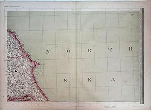
Yorkshire Coast. The Imperial Map of England & Wales.
Publication Date: 1868
Seller: theoldmapman, Weston super Mare, United Kingdom
Seller rating 5 out of 5 stars

Map
� 13
Convert currency� 5 shipping from United Kingdom to U.S.A.Quantity: 1 available
Add to basketSingle sheet. Original antique map with original hand colouring of the county boundaries as issued. The Imperial Map of England & Wales according to the Ordnance Survey, with the latest additions; shewing clearly every feature of the country, railways and their stations, Roads, Canals, Rivers, Gentlemen's Seats, &c. &c. On the Scale of 4 Miles to an Inch. 69 x 49.5 cm.
-
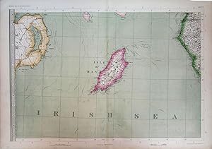
Isle of Man with parts of Northern Ireland & Cumberland. The Imperial Map of England & Wales.
Publication Date: 1868
Seller: theoldmapman, Weston super Mare, United Kingdom
Seller rating 5 out of 5 stars
Map
� 20
Convert currency� 5 shipping from United Kingdom to U.S.A.Quantity: 1 available
Add to basketSingle sheet. Original antique map with original hand colouring of the county boundaries as issued. The Imperial Map of England & Wales according to the Ordnance Survey, with the latest additions; shewing clearly every feature of the country, railways and their stations, Roads, Canals, Rivers, Gentlemen's Seats, &c. &c. On the Scale of 4 Miles to an Inch. 69 x 49.5 cm.
-
South & West Wales. The Imperial Map of England & Wales.
Publication Date: 1868
Seller: theoldmapman, Weston super Mare, United Kingdom
Seller rating 5 out of 5 stars
Map
� 24
Convert currency� 5 shipping from United Kingdom to U.S.A.Quantity: 1 available
Add to basketSingle sheet. Original antique map with original hand colouring of the county boundaries as issued. The Imperial Map of England & Wales according to the Ordnance Survey, with the latest additions; shewing clearly every feature of the country, railways and their stations, Roads, Canals, Rivers, Gentlemen's Seats, &c. &c. On the Scale of 4 Miles to an Inch. 69 x 49.5 cm.
-
Lincolnshire & North Norfolk. The Imperial Map of England & Wales.
Publication Date: 1868
Seller: theoldmapman, Weston super Mare, United Kingdom
Seller rating 5 out of 5 stars
Map
� 24
Convert currency� 5 shipping from United Kingdom to U.S.A.Quantity: 1 available
Add to basketSingle sheet. Original antique map with original hand colouring of the county boundaries as issued. The Imperial Map of England & Wales according to the Ordnance Survey, with the latest additions; shewing clearly every feature of the country, railways and their stations, Roads, Canals, Rivers, Gentlemen's Seats, &c. &c. On the Scale of 4 Miles to an Inch. 69 x 49.5 cm.
-
North Wales. The Imperial Map of England & Wales.
Publication Date: 1868
Seller: theoldmapman, Weston super Mare, United Kingdom
Seller rating 5 out of 5 stars
Map
� 24
Convert currency� 5 shipping from United Kingdom to U.S.A.Quantity: 1 available
Add to basketSingle sheet. Original antique map with original hand colouring of the county boundaries as issued. The Imperial Map of England & Wales according to the Ordnance Survey, with the latest additions; shewing clearly every feature of the country, railways and their stations, Roads, Canals, Rivers, Gentlemen's Seats, &c. &c. On the Scale of 4 Miles to an Inch. 69 x 49.5 cm.
-
Devon and the Bristol Channel; parts of Glamorganshire, Somerset and Cornwall. The Imperial Map of England & Wales.
Publication Date: 1868
Seller: theoldmapman, Weston super Mare, United Kingdom
Seller rating 5 out of 5 stars
Map
� 24
Convert currency� 5 shipping from United Kingdom to U.S.A.Quantity: 1 available
Add to basketSingle sheet. Original antique map with original hand colouring of the county boundaries as issued. The Imperial Map of England & Wales according to the Ordnance Survey, with the latest additions; shewing clearly every feature of the country, railways and their stations, Roads, Canals, Rivers, Gentlemen's Seats, &c. &c. On the Scale of 4 Miles to an Inch. 69 x 49.5 cm.
-
Northumberland with parts of Durham & Cumberland. The Imperial Map of England & Wales.
Publication Date: 1868
Seller: theoldmapman, Weston super Mare, United Kingdom
Seller rating 5 out of 5 stars
Map
� 24
Convert currency� 5 shipping from United Kingdom to U.S.A.Quantity: 1 available
Add to basketSingle sheet. Original antique map with original hand colouring of the county boundaries as issued. The Imperial Map of England & Wales according to the Ordnance Survey, with the latest additions; shewing clearly every feature of the country, railways and their stations, Roads, Canals, Rivers, Gentlemen's Seats, &c. &c. On the Scale of 4 Miles to an Inch. 69 x 49.5 cm.
-
Northern Home Counties of England & East Anglia. The Imperial Map of England & Wales
Publication Date: 1868
Seller: theoldmapman, Weston super Mare, United Kingdom
Seller rating 5 out of 5 stars
Map
� 26
Convert currency� 5 shipping from United Kingdom to U.S.A.Quantity: 1 available
Add to basketSingle sheet. Original antique map with original hand colouring of the county boundaries as issued. The Imperial Map of England & Wales according to the Ordnance Survey, with the latest additions; shewing clearly every feature of the country, railways and their stations, Roads, Canals, Rivers, Gentlemen's Seats, &c. &c. On the Scale of 4 Miles to an Inch. Creases down the map near the centrefold have been flattened and strengthened verso. 69 x 49.5 cm.
-
Central England. The Imperial Map of England & Wales
Publication Date: 1868
Seller: theoldmapman, Weston super Mare, United Kingdom
Seller rating 5 out of 5 stars
Map
� 28
Convert currency� 5 shipping from United Kingdom to U.S.A.Quantity: 1 available
Add to basketSingle sheet. Original antique map with original hand colouring of the county boundaries as issued. The Imperial Map of England & Wales according to the Ordnance Survey, with the latest additions; shewing clearly every feature of the country, railways and their stations, Roads, Canals, Rivers, Gentlemen's Seats, &c. &c. On the Scale of 4 Miles to an Inch. Closed split on lowest 8 cm of the centrefold. 69 x 49.5 cm.
-
Cornwall & S.W. Devon. The Imperial Map of England & Wales.
Publication Date: 1868
Seller: theoldmapman, Weston super Mare, United Kingdom
Seller rating 5 out of 5 stars
Map
� 28
Convert currency� 5 shipping from United Kingdom to U.S.A.Quantity: 1 available
Add to basketSingle sheet. Original antique map with original hand colouring of the county boundaries as issued. The Imperial Map of England & Wales according to the Ordnance Survey, with the latest additions; shewing clearly every feature of the country, railways and their stations, Roads, Canals, Rivers, Gentlemen's Seats, &c. &c. On the Scale of 4 Miles to an Inch. 74 x 26 cm.
-
North West England & North Midlands as far south as Nottinghamshire & N. Leicestershire. The Imperial Map of England & Wales.
Publication Date: 1868
Seller: theoldmapman, Weston super Mare, United Kingdom
Seller rating 5 out of 5 stars
Map
� 28
Convert currency� 5 shipping from United Kingdom to U.S.A.Quantity: 1 available
Add to basketSingle sheet. Original antique map with original hand colouring of the county boundaries as issued. The Imperial Map of England & Wales according to the Ordnance Survey, with the latest additions; shewing clearly every feature of the country, railways and their stations, Roads, Canals, Rivers, Gentlemen's Seats, &c. &c. On the Scale of 4 Miles to an Inch. 69 x 49.5 cm.
-
Westmoreland, most of Yorkshire & North Lancashire, S.E. Westmoreland & S. Durham. The Imperial Map of England & Wales.
Publication Date: 1868
Seller: theoldmapman, Weston super Mare, United Kingdom
Seller rating 5 out of 5 stars
Map
� 28
Convert currency� 5 shipping from United Kingdom to U.S.A.Quantity: 1 available
Add to basketSingle sheet. Original antique map with original hand colouring of the county boundaries as issued. The Imperial Map of England & Wales according to the Ordnance Survey, with the latest additions; shewing clearly every feature of the country, railways and their stations, Roads, Canals, Rivers, Gentlemen's Seats, &c. &c. On the Scale of 4 Miles to an Inch. 69 x 49.5 cm.
-
South of England; Somerset, Wiltshire, Berkshire, Hampshire & Dorset, etc. The Imperial Map of England & Wales.
Publication Date: 1868
Seller: theoldmapman, Weston super Mare, United Kingdom
Seller rating 5 out of 5 stars
Map
� 34
Convert currency� 5 shipping from United Kingdom to U.S.A.Quantity: 1 available
Add to basketSingle sheet. Original antique map with original hand colouring of the county boundaries as issued. The Imperial Map of England & Wales according to the Ordnance Survey, with the latest additions; shewing clearly every feature of the country, railways and their stations, Roads, Canals, Rivers, Gentlemen's Seats, &c. &c. On the Scale of 4 Miles to an Inch. 69 x 49.5 cm.
-
South East England; Kent, Surrey & Sussex. The Imperial Map of England & Wales.
Publication Date: 1868
Seller: theoldmapman, Weston super Mare, United Kingdom
Seller rating 5 out of 5 stars
Map
� 34
Convert currency� 5 shipping from United Kingdom to U.S.A.Quantity: 1 available
Add to basketSingle sheet. Original antique map with original hand colouring of the county boundaries as issued. The Imperial Map of England & Wales according to the Ordnance Survey, with the latest additions; shewing clearly every feature of the country, railways and their stations, Roads, Canals, Rivers, Gentlemen's Seats, &c. &c. On the Scale of 4 Miles to an Inch. 69 x 49.5 cm.