Order Total (1 Item Items):
Shipping Destination:

Japanese Government Railways (176 results)
Feedback
Skip to main search results
Search filters
Product Type
- All Product Types
- Books (52)
- Magazines & Periodicals (No further results match this refinement)
- Comics (No further results match this refinement)
- Sheet Music (No further results match this refinement)
- Art, Prints & Posters (No further results match this refinement)
- Photographs (No further results match this refinement)
- Maps (124)
- Manuscripts & Paper Collectibles (No further results match this refinement)
Condition Learn more
Binding
Collectible Attributes
- First Edition (8)
- Signed (No further results match this refinement)
- Dust Jacket (No further results match this refinement)
- Seller-Supplied Images (154)
- Not Print on Demand (174)
Language (3)
Free Shipping
Seller Location
Seller Rating
-
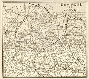
Condition: Good. Garut, West Java. "Environs of Garoet" sketch map. Indonesia 1920 old. Antique sketch map; Imperial Japanese Government Railways (1920). 7.0 x 8.0cm, 2.75 x 3.25 inches. Condition: Good. There is text printed on the reverse side.
-

Condition: Good. Garut, West Java. "Environs of Garoet" sketch map. Indonesia 1917 old. Antique sketch map; Imperial Japanese Government Railways (1917). 7.0 x 8.5cm, 2.75 x 3.25 inches. Condition: Good. The image shown may have been taken from a different example of this map than that which is offered for sale. The map you will receive is in good condition but there may be minor variations in the condition from that shown in the image. There is text printed on the reverse side.
-
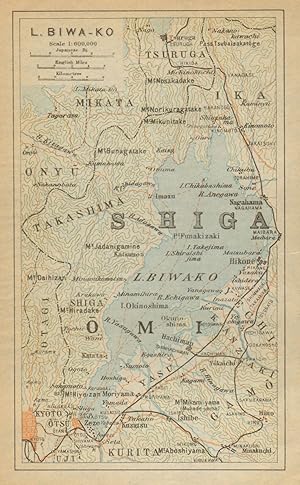
Condition: Good. Lake Biwa-ko. Shiga. Japan 1914 old antique vintage map plan chart. Antique colour map; Imperial Japanese Government Railways (1914). 14.5 x 9.0cm, 5.75 x 3.5 inches. Condition: Good. There is nothing printed on the reverse side, which is plain.
-
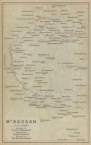
Condition: Good. Mount Aso-san,Aso Kuju National Park, Kumamoto, Kyushu. Japan 1914 old map. Antique colour map; Imperial Japanese Government Railways (1914). 15.0 x 9.5cm, 5.75 x 3.5 inches. Condition: Good. There is nothing printed on the reverse side, which is plain.
-
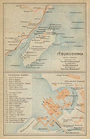
Condition: Good. Itsukushima island & shrine.Miyajima, Hiroshima Bay. Japan 1914 old map. Antique colour map; Imperial Japanese Government Railways (1914). 15.0 x 9.5cm, 6 x 3.75 inches. Condition: Good. There is nothing printed on the reverse side, which is plain.
-
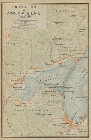
Condition: Good. Amanohashidate environs,Miyazu Bay. Kyoto Prefecture, Japan 1914 old map. Antique colour map; Imperial Japanese Government Railways (1914). 14.5 x 9.0cm, 5.5 x 3.5 inches. Condition: Good. There is nothing printed on the reverse side, which is plain.
-
Condition: Good. Izu Peninsula. Honshu. Japan 1914 old antique vintage map plan chart. Antique colour map; Imperial Japanese Government Railways (1914). 14.5 x 8.5cm, 5.75 x 3.25 inches. Condition: Good. There is nothing printed on the reverse side, which is plain.
-

First Edition. Paperback with tipped in colour illustration to front cover. Fold-out colour frontis with colour and b/w illustrations. Covers are worn and slightly browned. Ownership signature to half title page o/w contents sound. VG.
-
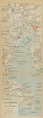
Condition: Good. Pilgrimage to Ise Shrines. Ise Bay & Nagoya. Japan 1914 old antique map chart. Antique colour map; Imperial Japanese Government Railways (1914). 23.5 x 8.5cm, 9.25 x 3.25 inches; this is a folding map. Condition: Good. Tight right margin. There is nothing printed on the reverse side, which is plain.
-
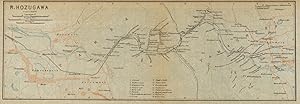
Condition: Good. River Hozugawa. Kameoka - Kyoto. Japan 1914 old antique vintage map plan chart. Antique colour map; Imperial Japanese Government Railways (1914). 9.5 x 27.5cm, 3.75 x 10.75 inches; this is a folding map. Condition: Good. Tight top margin. There is nothing printed on the reverse side, which is plain.
-

Condition: Good. Angkor Wat sketch map. Cambodia 1917 old antique vintage plan chart. Antique sketch map; Imperial Japanese Government Railways (1917). 11.5 x 8.0cm, 4.5 x 3.25 inches. Condition: Good. The image shown may have been taken from a different example of this map than that which is offered for sale. The map you will receive is in good condition but there may be minor variations in the condition from that shown in the image. There is text printed on the reverse side.
-
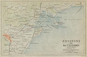
Condition: Good. Matsushima & environs. Sendai. Japan 1914 old antique vintage map plan chart. Antique colour map; Imperial Japanese Government Railways (1914). 9.5 x 15.0cm, 3.75 x 6 inches. Condition: Good. There is nothing printed on the reverse side, which is plain.
-
Condition: Good. Hibiya Park antique town city plan. Chiyoda City,Tokyo,Japan 1914 old map. Antique colour map; Imperial Japanese Government Railways (1914). 15.5 x 17.5cm, 6 x 7 inches; this is a folding map. Condition: Good. Tight bottom margin below caption. There is nothing printed on the reverse side, which is plain.
-
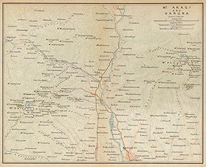
Condition: Good. Mount Akagai and Haruna. Maebashi. Japan 1914 old antique map plan chart. Antique colour map; Imperial Japanese Government Railways (1914). 15.0 x 18.5cm, 5.75 x 7.25 inches; this is a folding map. Condition: Good. There is nothing printed on the reverse side, which is plain.
-
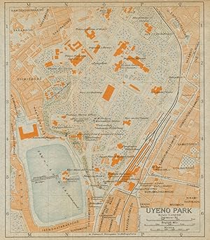
Condition: Good. Uyeno Park antique town city plan. Ueno Park, Taito, Tokyo. Japan 1914 old map. Antique colour map; Imperial Japanese Government Railways (1914). 15.0 x 13.5cm, 6 x 5.25 inches; this is a folding map. Condition: Good. There is nothing printed on the reverse side, which is plain.
-

Pocket Guide To Japan (With Special Reference to Japanese Customs, HIstory, Industry, Education, Art, Accomplishments, etc., etc.
Published by The Toppan Printing Co., Ltd., 1935
� 15.42
Convert currency� 20.97 shipping from U.S.A. to United KingdomQuantity: 1 available
Add to basketSoft cover. Condition: Good. Picture-filled guide to Japanese history. Front cover missing but book is in otherwise great condition. An interesting window to this oriental country's culture. (BR) Box 61.
-
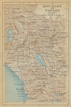
Condition: Good. Padang & environs. Mount Marapi. Bukittinggi. Sumatra. Indonesia 1917 old map. Antique colour map; Imperial Japanese Government Railways (1917). 15.0 x 10.0cm, 5.75 x 3.75 inches. Condition: Good. The image shown may have been taken from a different example of this map than that which is offered for sale. The map you will receive is in good condition but there may be minor variations in the condition from that shown in the image. There is nothing printed on the reverse side, which is plain.
-
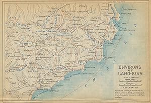
Condition: Good. Lang Biang environs. Binh Thuan, Ninh Thuan & Lam Dong. Vietnam 1917 old map. Antique colour map; Imperial Japanese Government Railways (1917). 10.0 x 15.0cm, 4 x 5.75 inches. Condition: Good. Tight top margin; The image shown may have been taken from a different example of this map than that which is offered for sale. The map you will receive is in good condition but there may be minor variations in the condition from that shown in the image. There is nothing printed on the reverse side, which is plain.
-
Condition: Good. Osaka and environs. Japan 1914 old antique vintage map plan chart. Antique colour map; Imperial Japanese Government Railways (1914). 15.5 x 17.0cm, 6 x 6.5 inches; this is a folding map. Condition: Good. Tight bottom margin below caption. There is nothing printed on the reverse side, which is plain.
-
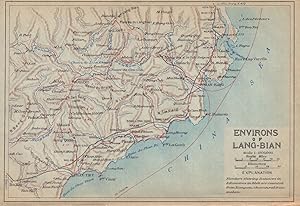
Condition: Good. Lang Biang environs. Binh Thuan, Ninh Thuan & Lam Dong. Vietnam 1920 old map. Antique colour map; Imperial Japanese Government Railways (1920). 10.0 x 15.0cm, 4 x 5.75 inches. Condition: Good. Tight top margin. There is nothing printed on the reverse side, which is plain.
-
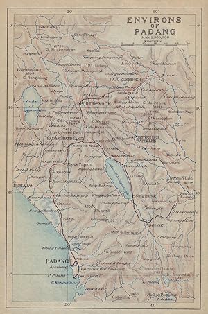
Condition: Good. Padang & environs. Mount Marapi. Bukittinggi. Sumatra. Indonesia 1920 old map. Antique colour map; Imperial Japanese Government Railways (1920). 15.0 x 10.0cm, 5.75 x 3.75 inches. Condition: Good. There is nothing printed on the reverse side, which is plain.
-
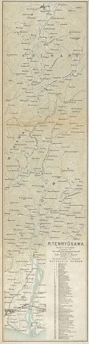
Condition: Good. River Tenryu-gawa. Iida - Hamamatsu. Honshu, Japan 1914 old antique map chart. Antique colour map; Imperial Japanese Government Railways (1914). 37.0 x 9.5cm, 14.5 x 3.75 inches; this is a folding map. Condition: Good. Tight right margin. There is nothing printed on the reverse side, which is plain.
-
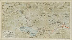
Condition: Good. Nikko & environs. Tochigi. Japan 1914 old antique vintage map plan chart. Antique colour map; Imperial Japanese Government Railways (1914). 14.0 x 25.5cm, 5.5 x 10 inches; this is a folding map. Condition: Good. There is nothing printed on the reverse side, which is plain.
-
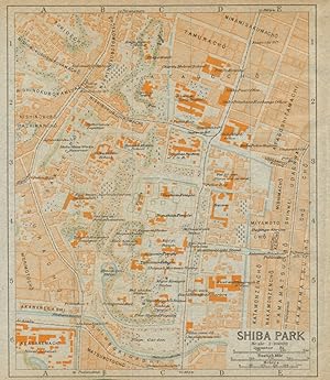
Condition: Good. Shiba Park antique town city plan. Minato, Tokyo. Japan 1914 old map. Antique colour map; Imperial Japanese Government Railways (1914). 15.5 x 13.5cm, 6 x 5.25 inches; this is a folding map. Condition: Good. Tight bottom margin below caption. There is nothing printed on the reverse side, which is plain.
-
Condition: Good. River Fuji-kawa. Kofu. Japan 1914 old antique vintage map plan chart. Antique colour map; Imperial Japanese Government Railways (1914). 29.0 x 9.0cm, 11.5 x 3.5 inches; this is a folding map. Condition: Good. Tight right margin. There is nothing printed on the reverse side, which is plain.
-
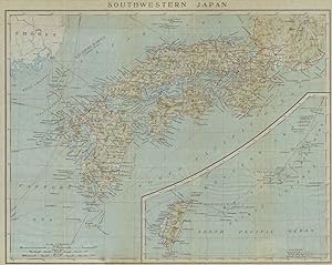
Condition: Good. South-Western Japan. Honshu, Shikoku, Kyushu & Taiwan 1914 old antique map. Antique colour map; Imperial Japanese Government Railways (1914). 34.5 x 43.0cm, 13.5 x 17 inches; this is a folding map. Condition: Good. Tight right margin. There is nothing printed on the reverse side, which is plain.
-

Condition: Good. Zamboanga town city sketch plan. Mindanao. Philippines 1917 old antique map. Antique sketch map; Imperial Japanese Government Railways (1917). 9.5 x 14.5cm, 3.75 x 5.75 inches. Condition: Good. The image shown may have been taken from a different example of this map than that which is offered for sale. The map you will receive is in good condition but there may be minor variations in the condition from that shown in the image. There is text printed on the reverse side.
-
JAPAN FOR THE YOUNG
Published by BOARD OF TOURIST INDUSTRY JAPANESE GOVERNMENT RAILWAYS, Tokyo, 1937
First Edition
� 22.33
Convert currency� 21.68 shipping from U.S.A. to United KingdomQuantity: 1 available
Add to basketSoft cover. Condition: Very Good. No Jacket. First Edition. Softcover book about 8-3/4 x 6 with 134 pages. Secure binding with clean pages and some rear fore edge rub marks and edge sun. Scarce. Size: 8vo - over 7� - 9�" tall. Book.
-
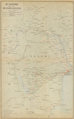
Condition: Good. Mount Hakone & envirosn. Odawara. Kanagawa Prefecture, Japan 1914 old map. Antique colour map; Imperial Japanese Government Railways (1914). 29.5 x 18.0cm, 11.5 x 7.25 inches; this is a folding map. Condition: Good. Tight right margin. There is nothing printed on the reverse side, which is plain.
-
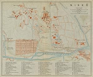
Condition: Good. Nikko antique town city plan. Tochigi. Japan 1914 old map chart. Antique colour map; Imperial Japanese Government Railways (1914). 15.0 x 18.0cm, 5.75 x 7 inches; this is a folding map. Condition: Good. There is nothing printed on the reverse side, which is plain.