
Order Total (1 Item Items):
Shipping Destination:

Iraq Kuwait (5 results)
Skip to main search results
Search filters
Product Type
- All Product Types
- Books (4)
- Magazines & Periodicals (1)
- Comics (No further results match this refinement)
- Sheet Music (No further results match this refinement)
- Art, Prints & Posters (No further results match this refinement)
- Photographs (No further results match this refinement)
- Maps (No further results match this refinement)
- Manuscripts & Paper Collectibles (No further results match this refinement)
Condition Learn more
- New (No further results match this refinement)
- As New, Fine or Near Fine (No further results match this refinement)
- Very Good or Good (2)
- Fair or Poor (No further results match this refinement)
- As Described (3)
Binding
Collectible Attributes
- First Edition (1)
- Signed (No further results match this refinement)
- Dust Jacket (No further results match this refinement)
- Seller-Supplied Images (5)
- Not Print on Demand (5)
Language (2)
Free Shipping
- Free Shipping to U.S.A. (No further results match this refinement)
Seller Location
Seller Rating
-
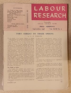
Labour Research September, 1958 / MIDDLE EAST: BACKGROUND TO CRISIS 1. IRAQ- FEUDALISM AND POVERTY 2. THE ARTIFICIALITY OF JORDAN 3. HIGH PROFITS IN KUWAIT - For How Long? / TORY THREAT TO TRADE UNIONS / Labour's Plan for Agriculture / T W Cyborg Jones "Co-operative Management and the Workers" / Education in 1957
Published by L.R.D. (Publications) Ltd, 1958
Magazine / Periodical
Soft cover. Condition: Very Good. 16 pages. MIDDLE EAST: BACKGROUND TO CRISIS 1. IRAQ- FEUDALISM AND POVERTY 2. THE ARTIFICIALITY OF JORDAN 3. HIGH PROFITS IN KUWAIT - For How Long? / TORY THREAT TO TRADE UNIONS / Labour's Plan for Agriculture / T W Cyborg Jones "Co-operative Management and the Workers" / Education in 1957 (SL#96).
-
Final Report on the Demarcation of the International Boundary between the Republic of Iraq and the State of Kuwait by the United Nations Iraq-Kuwait Boundary Demarcation Commission (S/25811, 21 May 1993).
Language: English
Published by [s.l.] ; United Nations, Security Council [ca. 1993]., 1993
Seller: Antiquariat Thomas Haker GmbH & Co. KG, Berlin, Germany
Association Member: GIAQ
Seller rating 5 out of 5 stars

Hardcover/Pappeinband. Condition: Gut. [Ca. 400 p.] ; 4 maps. Guter Zustand. Schmuckausgabe im Schuber. Bibliotheksexemplar mit Stempeln und Signatur auf Einband. Sonst Seiten sauber. Englisch-Arabisch./ Good. Special edition in slipcase. Ex-library with usual markings. Clean pages. English-Arabic. Sprache: Englisch Gewicht in Gramm: 3100.
-

Iraq.
Published by Istanbul, [Erkan-i Harbiye-i Umumiye], [1915 CE =] 1331 Rumi., 1915
Seller: Antiquariat INLIBRIS Gilhofer Nfg. GmbH, Vienna, A, Austria
Association Member: ILAB VDA VDAO
Seller rating 5 out of 5 stars
First Edition
655 x 660 mm. Lithograph in colours, dissected into 12 sections and mounted on original cloth. First edition of the first accurate Ottoman general map of Central and Southern Iraq, Kuwait, and Khuzestan (Iran); the authoritative map used by the Ottoman Army for strategic planning during the "Mesopotamia Campaign", during which Ottoman-German forces mounted a unexpectedly strong resistance to Britain's invasion of Iraq in World War I. Examples of the present map were used by Ottoman commanders who oversaw the successful Ottoman-German defence of Baghdad at the Battle of Battle of Ctesiphon (22-25 Nov. 1915), as well as the capture of the main British army at the Siege of Kut-al-Amara (7 Dec. 1915-29 April 1916). - With text entirely in Ottoman Turkish, the map is based on the British War Office's "Lower Mesopotamia Between Baghdad and the Persian Gulf" (1911), which was itself in part based on Ottoman sources. Both maps were dramatically superior in all respects to previous efforts, forming the culmination of over three generations of reconaissance, capped by critical late-breaking discoveries. - Some light staining in margins and in lower-right quadrant, but generally in good condition. Very rare.
-

Index Map of Iraq and Kuwait with oil fields.
Published by No place, 1959 / 1970., 1970
Seller: Antiquariat INLIBRIS Gilhofer Nfg. GmbH, Vienna, A, Austria
Association Member: ILAB VDA VDAO
Seller rating 5 out of 5 stars
Colour printed map, max. 520 x 485 mm. Scale 1:2,000,000. Comprising 2 maps joined, with sections cut out to facilitate joining. A detailed map of the oil industry in Iraq and Kuwait. Originally printed in August 1959, it was updated in 1969 (north Iraq) and 1970 (south Iraq), and maps many aspects of oil drilling, production, and transport in the region. Large oil fields are shown, including Burgan, Magwa, and Wafra, as well as Kirkuk and Zubair in Iraq. Dozens of major test wells dot the landscape, and pipeline routes with their pump stations stretch across Iraq and Saudi Arabia. The map also shows useful roads and railways as well as geological features like wadis and floodplains. Altogether an interesting summary of oil interests in the region in the early 1970s. - Apparently extracted from an oil industry publication,2 parts conjoined with packaging tape on reverse, light wear, pin holes, and hole-punches in the margins.
-

Manuscript map of Baghdad Vilayet and Basra Vilayet.
Published by [Probably Istanbul, ca. 1915]., 1915
Seller: Antiquariat INLIBRIS Gilhofer Nfg. GmbH, Vienna, A, Austria
Association Member: ILAB VDA VDAO
Seller rating 5 out of 5 stars
Ca. 235 x 190 mm. Original hand-coloured map on tissue paper. In Ottoman script and Arabic. Two hand-drawn maps on a single sheet, made in the Ottoman Empire, likely in Istanbul, near the beginning of the 20th century. The map to the left depicts the Baghdad Vilayet, embracing Central Iraq. The map on the right features the Basra Vilayet, extending from Southern Iraq down the southern coast of the Arabian Gulf to include Kuwait, what is now the Dhahran area of Saudi Arabia, Bahrain, and Qatar. By the late 19th century the Gulf States had become de-facto British protectorates and were no longer practically subject to Ottoman rule; still, the Sublime Porte never relinquished its sovereignty. - Maps such as this, executed on thin tracing paper, were commonly made as educational tools at elite Ottoman schools and universities during the early 20th century, although few such specimens survive. - Clean and bright, with light creasing and traces of an old vertical centrefold.
