
Order Total (1 Item Items):
Shipping Destination:

Homanns Erben (18 results)
Skip to main search results
Search filters
Product Type
- All Product Types
- Books (10)
- Magazines & Periodicals (No further results match this refinement)
- Comics (No further results match this refinement)
- Sheet Music (No further results match this refinement)
- Art, Prints & Posters (No further results match this refinement)
- Photographs (No further results match this refinement)
- Maps (8)
- Manuscripts & Paper Collectibles (No further results match this refinement)
Condition Learn more
- New (No further results match this refinement)
- As New, Fine or Near Fine (No further results match this refinement)
- Very Good or Good (1)
- Fair or Poor (No further results match this refinement)
- As Described (17)
Binding
- All Bindings
- Hardcover (1)
- Softcover (No further results match this refinement)
Collectible Attributes
- First Edition (No further results match this refinement)
- Signed (No further results match this refinement)
- Dust Jacket (No further results match this refinement)
- Seller-Supplied Images (14)
- Not Print on Demand (18)
Language (2)
Price
- Any Price
- Under � 20 (No further results match this refinement)
- � 20 to � 35 (No further results match this refinement)
- Over � 35
Free Shipping
- Free Shipping to U.S.A. (No further results match this refinement)
Seller Location
Seller Rating
-

Neueste Charte von Frankreich, eingetheilet in seine alten und neuen Departements.
Published by N�rnberg Homanns Erben, 1807
Seller: Libelle mit H & B, Basel, Switzerland
Association Member: ILAB VEBUKU
Seller rating 2 out of 5 stars

Verbessert und vermehrt8�. 18 Segmente. Auf Leinen aufgezogen, in Kartonetui. Fl�sse blau, Departementsgrenzen rot koloriert. - Das Etui mit zeitgen�ssischem Besitzervermerk. An den Ecken L�chlein einer fr�heren Nagelfixierung.
-

LA GENERALIT� PROPRIETAIRE DE LYON, DIVIS�E EN SES V ELECTIONS.
Published by Homann, N�rnberg, 1762
Seller: Antiquariat Reinhold Berg eK Inh. R.Berg, Regensburg, Germany
Seller rating 5 out of 5 stars

Map
Original antike Kupferstichkarte in zeitgen�ss. Grenz- u. Fl�chenkolorit. Links unten befindet sich die Kartusche mit Titel, Meilenzeiger u. Legende, dekorativ umrahmt von allegorischen Darstellungen, dar�ber ist das Wappen von Lyon eingraviert. Oben im Titel bezeichnet und datiert ? sous des Heritiers d'Homan 1762'. Guter Erhaltungszustand. Einige Falten im Bereich des Mittelfalzes. 46 x 56 cm (18 x 22 inches).
-

Bavariae Circulus et Electoratus in suas quasque Ditiones tam cum Adiacentibus quam insertis Regionibus accurati�ime divisus per Io. Baptistam Homannum Norimbergae
Published by N�rnberg, 1780
Seller: Antiquariat Reinhold Berg eK Inh. R.Berg, Regensburg, Germany
Seller rating 5 out of 5 stars
Map
Other. Original antike Kupferstichkarte in zeitgen�ss. Grenz- u. Fl�chenkolorit. Rechts oben Muschelkartusche mit Titel, Meilenzeiger u. Legende, dekorativ umrahmt von allegorischen Darstellungen (Wappen v. Putten gehalten, Neptun, etc.). Dargestellt wird der bayr. Kreis von Homann nach dem Teschener Frieden. Das Kartenbild entspricht, bis auf die politischen Grenzen, der Ausgabe von Homann,J. B. von 1728. Die Kupferplatte wurde neu gestochen und weist im un teren Rand auf die ab 1779 durch den Teschener Frieden zustandegekommenen politischen Ver�nderungen hin ( Das violet blau bedeckte Land haben Ihro Roem. Kaiserl. Maj. durch den Teschener Frieden erhalten. ). 2 kleinere althin terlegte Einrisse am �u�eren Rand, sonst sch�nes kr�ftig gedrucktes Exemplar in sorgf�ltigem zeitgen�ss. Kolorit. Leichte Gebrauchsspuren. 560 by 480mm (22 by 19 inches).
-

Bavariae Circulus et Electoratus in suas quasque Ditiones tam cum Adiacentibus quam insertis Regionibus accurati�ime divisus per Io. Baptistam Homannum Norimbergae
Published by N�rnberg, 1780
Seller: Antiquariat Reinhold Berg eK Inh. R.Berg, Regensburg, Germany
Seller rating 5 out of 5 stars
Map
Original antike Kupferstichkarte in zeitgen�ss. Grenz- u. Fl�chenkolorit. Rechts oben Muschelkartusche mit Titel, Meilenzeiger u. Legende, dekorativ umrahmt von allegorischen Darstellungen (Wappen v. Putten gehalten, Neptun, etc.). Dargestellt wird der bayr. Kreis von Homann nach dem Teschener Frieden. Das Kartenbild entspricht, bis auf die politischen Grenzen, der Ausgabe von Homann,J. B. von 1728. Die Kupferplatte wurde neu gestochen und weist im un teren Rand auf die ab 1779 durch den Teschener Frieden zustandegekommenen politischen Ver�nderungen hin ( Das violet blau bedeckte Land haben Ihro Roem. Kaiserl. Maj. durch den Teschener Frieden erhalten. ). 2 kleinere althin terlegte Einrisse am �u�eren Rand, sonst sch�nes kr�ftig gedrucktes Exemplar in sorgf�ltigem zeitgen�ss. Kolorit. Guter Erhaltungszustand. 560 by 480mm (22 by 19 inches).
-
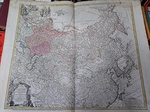
Imperii Russici et Tartariae Universae . opera Ioh. Mathiae Hasii Math. P.P. . Impensis Homannianorum Heredum Norib. A 1730. Alt grenzkolorierte Kupferstich-Karte mit zwei Kartuschen, oben mit Portr�t von Anna Iwanowna (auch: Anna Ioannowna, Kaiserin von 1730-1740).
Published by N�rnberg, Homanns Erben [Homann]., 1730
48 x 57 cm. Blattgr��e 52,5 x 62,8 cm. Leicht gebr�unt, R�nder st�rker u. teils fleckig bzw. abgegriffen. Der obere Rand feuchtigkeitsspurig u. stockfleckig. - Zeigt ganz Russland, von Finnland, Litauen, Polen . sowie Japan und das n�rdliche China - Versandkosten innerhalb Deutschlands EUR 5,00 (versicherter Versand).
-
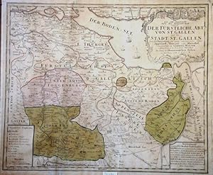
St.Gallen/Kantonskarte, Originaltitel: "DER F�RSTLICHE ABT VON ST. GALLEN."
Published by N�rnberg, 1766
Seller: Graphica-Antiqua, Stich-Galerie Osvald, St.Gallen, SG, Switzerland
Seller rating 4 out of 5 stars

altkol. Kupferstich, 50x70cm, B�ttenpapier gebr�unt, Blatt unsauber,
-

Mappa Geographica Regni Poloniae ex novissimis quotquot sunt mappis specialibus composita et ad L.L. stereographica projectionis revocata a Tob. Mayero. Carte des Etats de la Couronne de Pologne, nouvellement dessin�e par Mr. Tob. Mayer et publiee par les Heritiers de Homann. Mit Kopftitel in franz�sischer Sprache. Altkolorierte Kupferstich-Karte mit Titel- und Wappen-Kartusche.
Published by N�rnberg, Homanns Erben., 1757
46 x 52 cm. Blattgr��e 52 x 62,5 cm. Leicht gebr�unt, R�nder etwas st�rker u. etwas fleckig bzw. leicht abgegriffen. Der obere Rand u. die unteren Ecken feuchtigkeitsspurig, oben teils stockfleckig. - Versandkosten innerhalb Deutschlands EUR 5,00 (versicherter Versand).
-

Egerani Circulus Repraesentatio Geographice Circuli Egerani, nec non Elnbogensis, in quo simulviae Egeranae in Thermas Carolinas sistincta delineatio con spietur. Ex prototyp Mulleriano majori omnia desumata.
Published by Homanns Erben, N�rnberg, 1742
Seller: Antiquariat Reinhold Berg eK Inh. R.Berg, Regensburg, Germany
Seller rating 5 out of 5 stars
Map
Original antique copper engraving. Hand colored in outline and wash. This decorative map shows the Kingdom of Bohemia. The map is equipped with many locations, rivers, mountains, forests, etc. The individual regions are hand-colored in different colors. The title cartouche is in the upper right corner, and we also find a small cartouche with an explanatory legend and mile marker in the lower left corner. "Johann Baptist Homann (born March 20, 1664 in Oberkammlach, today part of Kammlach in the Unterallg�u district; July 1, 1724 in Nuremberg) was a German cartographer, publisher, engraver and made globes. Johann Baptist Homann died on January 1st July 1724. His company passed to his son Johann Christoph Homann (1703-1730). He appointed his two managing directors, Johann Georg Ebersberger (or Ebersperger) and Johann Michael Franz, as heirs of the business. After his death, the company went under continued under the name "Homanns Erben" (also "Homannsche Erben" or "Hom�nnische Erben", French Heritiers de Homann, lat Homannianos Heredes). In the middle of the 18th century, renowned scholars such as Johann Michael Franz, Tobias Mayer, Johann Gabriel Doppelmayr, Georg Moritz Lowitz, Johann H�bner and Johann Gottfried Gregorii worked for the company. The long and eventful success story of the industry leader only ended in 1848 with the death of the last owner, Christoph Franz Fembo." - Wikipedia In excellent condition. 51 x 56 cm (20 x 22 inches).
-
Repraesentatio geographica circuli Egerani, nec non Elnbogensis, in quo simul viae Egeranae in Thermas Carolinas distincta delineatio conspicitur. Ex prototypo Mulleriano majori omnia desumta, sed passim emendata et Territorio Aschensi rectius designato aucta. Carte du Territoire d'Egra, & du Cercle d'Elnbogue, qui en est limitrophe, ou l'on a marque au juste les chemins des plusieurs Endroits & particulierement celui de la ville d'Egra a celle de Carlsbad, suivant le grand Original de Mr. Muller, corrig�e ca & la & augment�e par le Territoire d'Asch. Altkolorierte Kupferstich-Karte.
Published by (N�rnberg), Homann Erben, 1742., 1742
Seller: Antiquariat am Moritzberg, Hildesheim, NDS, Germany
Seller rating 1 out of 5 stars

53 x 57 cm. Gerahmt (ca. 1970). Lateinisch-franz�sische Titelei in 2 Bannern am Kopf, dazwischen das Wappen in einer Kartusche, darunter die Meilenzeiger; links unten eine Kartusche mit der Legende, die auch die Vorkommen von Gold, Silber, Kupfer, Schwefel und Eisen anzeigt. Rahmen etwas besto�en und mit Fehlstellen. DE.
-

Regnum Bosniae, una cum finitimis Croatiae, Dalmatiae, Slavoniae, Hung. et Serviae partibus, adjuncta praecipuorum in his regionibus munimentorum ichnographica. Curantibus Homanianis Norib. Cum B.S.C.M.
Published by Homann, N�rnberg, 1739
Seller: Antiquariat Reinhold Berg eK Inh. R.Berg, Regensburg, Germany
Seller rating 5 out of 5 stars
Map
Original copper engraing, hand colored when published. Decorative map of Bosnia and Serbia, probably international published around 1739 on the occasion of the Russian-Austrian Turkish War (1736-1739). With 15 plans and views of Raca, Sabac, Beogad, Orsova, Vidin, Nikopol, Ni?, Cacak, Sarajevo, Kragujevac and Valjevo, Uzice, Slavonski Brod, Zvornik, Explanations of the war (A-Z) in the upper right corner. Oversize map, printed from two plates. On the right side one of the foldes near the plan of Nizza with an larger loss. Further some marginal mendings and repairs. Still in good condition. 510 by 1130mm (20 by 44� inches).
-

Die Gegend des Rheins von Speyer bis Mayntz nebst der Situation l�ngst der Bergstrasse zwischen dem Rhein und dem Odewaldt dem Mayn und Neckar 1735 Im Verlag der Homaennischen Erben Die Gegend des Rheins von Speyer bis Mayntz nebst der Situation l�ngst der Bergstrasse zwischen dem Rhein und dem Odewaldt dem Mayn und Neckar 1735 Im Verlag.
Published by Homanns Erben, N�rnberg, 1735
Seller: Antiquariat Reinhold Berg eK Inh. R.Berg, Regensburg, Germany
Seller rating 5 out of 5 stars
Map
Hand-Colored Original Copperplate Engraving by Homanns Erben, depicting Die Gegend des Rheins von Speyer bis Mayntz nebst der Situation l�ngst der Bergstrasse zwischen dem Rhein und dem Odewaldt dem Mayn und Neckar 1735 Im Verlag der Homaennischen Erben. Published N�rnberg, Homanns Erben, 1735. Sheet: 330 by 920mm (13 by 36 inches). A fine and original hand-colored example of Homanns Erben's celebrated cartographic work, documenting this region of Germany with the precision and decorative artistry characteristic of the 17300s. Johann Baptist Homann (1664-1724) was the foremost map publisher of 18th-century Germany. Born in Bavaria, he founded his cartographic publishing house in Nuremberg in 1702 and within a decade had become the dominant force in German-language cartography. In 1715, Holy Roman Emperor Charles VI appointed him Imperial Cartographer -- a prestigious title that gave Homann access to the most current geographic data and exclusive publishing privileges. His maps are celebrated for their bold copper engraving, elaborate Baroque cartouches, and vivid original hand coloring. Following Homann's death in 1724, the firm continued under the imprint 'Homann Heirs' (Homannsche Erben). His maps are held in major collections worldwide, including the Library of Congress, the British Library, and the Bayerische Staatsbibliothek.This original copperplate engraving, with original hand coloring depicts the region of Die Gegend des Rheins von Speyer bis Mayntz nebst der Situation l�ngst der Bergstrasse zwischen dem Rhein und dem Odewaldt dem Mayn und Neckar 1735 Im Verlag der Homaennischen Erben, published in N�rnberg, Homanns Erben, 1735. The map records the political and geographic boundaries of the region as understood in 1735, offering a fascinating window into the history of German territorial organization. Sheet measures 330 by 920mm (13 by 36 inches). Professionally restored; the image area is fully intact and displays well. Ready to frame. In gutem Zustand. Gefaltet im Atlas erschienen. Au�erhalb der Darstellung im unteren Blattbereich einige Wasserr�nder. Die linke Blatth�lfte ist etwas vergilbter. 330 by 920mm (13 by 36 inches).
-

Iconografica Rappresentatione della Inclita Citta di Venetia Con tuti i Canali, Ry, Chaese, Ponti, Isolette,Division de Sestieri. i.e. Vrbs Venetiarum ad Exemplar Typi majoris, qui Sereni�imo Senatui Veneto consercratus, Venetys 1729 prodist in hanc minorem formam redata. Curantibus Homannianis Herdibus Norim. Cum P. S. C. M.
Published by Homann Heirs, N�rnberg, 1729
Seller: Antiquariat Reinhold Berg eK Inh. R.Berg, Regensburg, Germany
Seller rating 5 out of 5 stars
Map
Original copper engraving, hand colored in outline and wash when published. A magnificent, large-scale bird's eye view of Venice over a panoramic view of the city. In the upper right corner is the title cartouche and in the lower area a list of the buildings (A-Z and 1-96). In excellent condition. 47.4 x 57,8 cm (18.75 x 22,75 inches).
-

Carte de Indes Orientales dessinee suivant les Observations. Carte Des Indes Orientales dessin�e suivant les Observations les plus recentes, dont le principal est tir�e des Cartes hydrographiques de Mr. D'Apres de Mannevillette. Dedi�e tts humblement a son Altese Serenisisime . L' Auteur & les Heritiers de Homan. L' An 1748.
Published by Homann s Erben, N�rnberg, 1748
Seller: Antiquariat Reinhold Berg eK Inh. R.Berg, Regensburg, Germany
Seller rating 5 out of 5 stars
Map
Original engraved map, printed from two plates and handcolored in wash and outline when published. A highly detailed and large map of South East Asia with Malacca, Sumatra, Borneo, the islands of the Philippines and the nothern tip of Australia (Nova Hollandia). Published by Homann s Heirs and engraved after a drawing by Tobias Meyer in 1748. The left half of the map shows India with Delhi all the way to Burma, Vietnam, Laos, Malaysia, Sumatra and Singapore as well as the Maldives with the Indian Ocean. The right half of the map depicts the Philippines, Java, Borneo, Papua New Guinea and Eastern China. The title cartouche can be found on the left bottom including a dedication to the former Prince of Orange - Nassau, Wilhelm IV. Many engraved place names, mountains, rivers, lakes, political border are engraved on the map. The map was printed from two plates, these two sheets were joined together and then pasted down on cardboard. The upper margin cut close to the printed title at the top of the map, the bottom cut close to the engraved printed border line. A good impression in decorative hand colors of the period when published, mounted on cardboard. A good example. 50.5 x 87,5 cm (20 x 34,5 inches).
-
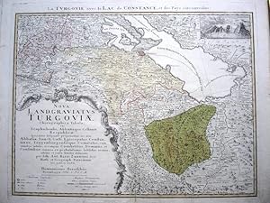
Thurgau-Karte mit Bodensee, Originaltitel:LA TURGOVIE AVEC LE LAC DE CONSTANCE ,
Published by N�rnberg, 1766
Seller: Graphica-Antiqua, Stich-Galerie Osvald, St.Gallen, SG, Switzerland
Seller rating 4 out of 5 stars
Kupferstich, altes Fl�chenkolorit, 42x55.5cm, vollrandig, Mittelfalz, Rheinfall-Kartusche oben rechts, sch�ner Zustand, copperengraving, old coloring,
-

Neuester und exacter Plan und Prospect von der Stadt, Vestung, Bay und Fortification von Gibraltar. Theils wie es Lit. A mit den Approchen der Spanier, die sie im letztern Krieg daf�r gemacht, zu sehen, theils wie es Lit. B seit der letztern Belagerung 1727 von den Engell�ndern zu besserer Sicherheit mit neuen Fortifications-Werckern vermehrt und fast un�berwindlich gemacht, von den Spaniern hingegen gegen die Land-Seyte zu bey etlichen Jahren her mit neuen Linien eingeschlossen worden, nach einem englischen Original nebst deutlichen und vollst�ndigen Anmerckungen accurat herausgegeben.
Language: German
Published by N�rnberg, Homann,, 1733
Seller: Antiquariat Werner Steinbei�, M�nchen, Germany
Seller rating 4 out of 5 stars
altkolorierte Kupferstichkarte mit vier Ansichten von Gibraltar und dem spanischen Cadiz, ausf�rhliche Beschreibungen. - zarter Wasserrand im oberen wei�en Rand, linke untere Ecke mit Quetschfalte, gut erhaltenes Blatt Sprache: Deutsch Gewicht in Gramm: 550 47,5 x 57 cm Blattgr��e 53,5 x 63,5 cm.
-
Septem Provinciae Belgium Foederatum quod generaliter Hollandia.
Language: German
Published by Amsterdam,, 1748
51,6 x 47,0 cm. Color. Kupferstich mit Wappenkartusche,. Sprache: Deutsch.
-
Color. Kupferstich mit Kartusche,. 52 x 58,2 cm R�nder gering angeschmutzt. Sprache: Deutsch.
-
Kein Einband. Condition: Gut. Grenzkolorierte Kupferstichkarte. 49 x 59 cm (Einfassungslinie). Mit Passepartout unter Glas in moderner Goldleiste gerahmt. 70 x 78 cm. - Rand gebr�unt. Nicht ausgerahmt, daher mit m�glichen Randl�suren. Versand nur ohne Rahmen. Karte.
