Order Total (1 Item Items):
Shipping Destination:

George Philip Son: Maps (147 results)
Skip to main search results
Search filters
Product Type
- All Product Types
- Books (No further results match this refinement)
- Magazines & Periodicals (No further results match this refinement)
- Comics (No further results match this refinement)
- Sheet Music (No further results match this refinement)
- Art, Prints & Posters (No further results match this refinement)
- Photographs (No further results match this refinement)
- Maps (147)
- Manuscripts & Paper Collectibles (No further results match this refinement)
Condition Learn more
Binding
Collectible Attributes
- First Edition (1)
- Signed (No further results match this refinement)
- Dust Jacket (No further results match this refinement)
- Seller-Supplied Images (140)
- Not Print on Demand (147)
Language (2)
Free Shipping
- Free Shipping to U.S.A. (No further results match this refinement)
Seller Location
Seller Rating
-
Philips' Authentic Series of Maps: Sweden and Norway. And the New Baltic States.
Language: English
Published by George Philip & Son. Ltd., London
Seller: Kerr & Sons Booksellers ABA, Cartmel, CMA, United Kingdom
Seller rating 5 out of 5 stars

Map
Soft cover. Condition: Very Good. No date, circa early 20th century. Folding Map. Not-backed. 24 sections. Printed outline colour. Measures 54cm x 68cm approx. Small tear to lower right margin. In the original card covers, some creasing and edge wear. Stamp to front and rear cover for "Fell & Rock Climbing Club".
-

LONDON & NORTH EASTERN RAILWAY and Connecting Railways.
Published by London July, 1930
Seller: AMBRA BOOKS (Aitchison & Cornish), Bristol, United Kingdom
Seller rating 3 out of 5 stars

Map
Folding map size 27" x 16", printed in blue and black, with lines in red. Shows L.N.E.R and Joint Lines, Track of 'Flying Scotsman'. Other Railways, Road Services. Folding into 8vo orange printed wraps, partly split at spine. --- Please e-mail for one of my FREE CATALOGUES which include GENERAL [ Manuscripts, Maps, Ephemera, Views, etc., etc. ] ---.
-
Nightingale's New Survey Map of Gloucester, Warwick, Worcester, Oxford, Hereford, Buckingham, Berks and Parts of Adjoining Counties.
Published by UK: Nightingale c, 1910
Seller: David Ford Books PBFA, Cley-next-the-Sea, United Kingdom
Association Member: PBFA
Seller rating 5 out of 5 stars
Map
� 28 20% off� 22.40
� 22 shipping
Ships from United Kingdom to U.S.A.Quantity: 1 available
Add to basketCondition: very good. Map. HB. Undated but previous owner has inscribed on cover 'about 1920'- looks earlier in style however, perhaps 1900-10. Multi-coloured map printed on paper laid onto linen, folding into purple cloth covers lettered in gilt to front and spine, with marbled paper inside cover and on front section of map. Divided into 40 sections, measuring 93 x 122cm unfolded, folded up 24 x 13.5cm. Scale of 3 miles to an inch. Showing (in different colours) County Boroughs, Municipal Boroughs, Urban Districts, Rural Districts, Railways, Roads, Road Distances, Parks, Woods etc. At the edges of the map area are text panels with Indexes to Parishes and tables of districts, with acreage, population etc. Good condition overall : map face is generally very good, clean and bright, but with a tear across lower right index panel. The covers are worn and faded, with abraded corners and spine edges, and various marks.
-

New Concise World Atlas
Language: English
Published by Oxford University Press Apr 2021, 2021
ISBN 10: 0197551742 ISBN 13: 9780197551745
Map
Buch. Condition: Neu. Neuware - With hundreds of full-color, large-format maps and beautiful satellite imagery, the sixth edition of the New Concise World Atlas delivers a fully updated, diverse collection of geographical information in one well-organized, manageable volume.
-

Philips Authentic Imperial Maps Spain For Tourists and Travelers
Published by George Philips, 1930
Seller: Fantastic Book Discoveries, Cockeysville, MD, U.S.A.
Seller rating 5 out of 5 stars
Map
No Binding. Condition: Good. No Jacket. unknown date, folding color map of Spain.
-
Philips Authentic Imperial Maps for Tourists and Travellers: China
Language: English
Published by George Philip and Son, London, 1910
Map
Hardcover. Condition: Very Good. Folding map, linen backed approx 26" x 22" in the cloth binding, undated but circa 1910. The cloth is lightly worn, the map is in near fine condition with no browning to the linen or wear. Scarce.
-

Syria and Palestine (cover title: Syria, Palestine and the Sinai Peninsula). 1:1.140.000. (= Philips authentic imperial maps for tourists & travellers).
Language: English
Published by Georg Philip / The London Geographical Institute c. 1920., 1920
Seller: Antiquariat An der Vikarie, Grafschaft-Leimersdorf, Germany
Association Member: GIAQ
Seller rating 5 out of 5 stars
Map
outline colored folded map (c. 54 x 70 cm), with an insert "The Sinai Peninsula and the Egyptian Frontier", mounted on linen, folder a bit rubbed and stained, map a bit stained, with some little markings / entries and little tears / damages at some folds, else good, Sprache: Englisch Gewicht in Gramm: 250 in original yellow hardcover folder,
-
Arabia, the Red Sea, and the Valley of the Nile, including Egypt, Nubia, and Abyssinia (Philips New Series of Imperial Maps for Tourists & Travellers) / Philips Travelling Maps - Arabia with Index [cover title]
Language: English
Published by George Philip & Son, London, 1904
Map
Hardcover. Condition: Near Fine. Colour paper map 68x54cm dissected into 21 sections and mounted on linen, folding into its original black-titled and decorated red cloth case 11x19cm, with (27)pp Index of Names bound in, and (1)pp publisher's advert mounted opposite. The map is near fine, yellowing with a couple of small black ink annotations in the Hejaz, the case very good, missing the ribbon tie and gently rubbed to extremities. Centred on the Arabian Peninsula, this shows the area bounded by the Nile from the Delta to Nuer (W), Lake Tiberias and Isfahan (N), and British Somaliland (S) on a scale of 1 degree to 69.15 miles (1 inch to 90 miles). Undated, but possibly between September 1904 (with the Hejaz Railway reaching as far as Maan) to 1 October 1906 (when the British imposed a new frontier between Sinai and Palestine, which does not look exact at this stage). The regions of Arabia are named (Asir, El Hejaz, El Nejd, El Hassa, Yemen etc). Qatar, Bahrain, Muscat and Oman are labelled, as are each of the Emirates (Abu Thabi, Debai, Shargeh, Ajman, Um el Khuweyn, Ras al Kheymah, Fejerah, Khor Kalba) with reference to the "Pirate Coast". Features include the Hajj route from Egypt, and other routes to Mecca including one from Oman (a straightish line timed at 21 days that peters out at the edge of the Rub al Khali, which was removed from the Authentic Imperial Map reissue), railways, steamer routes, submarine cables, relief by hachures, and heights in feet. There is also a glossary for Arabic, Persian and Turkish terms.
-
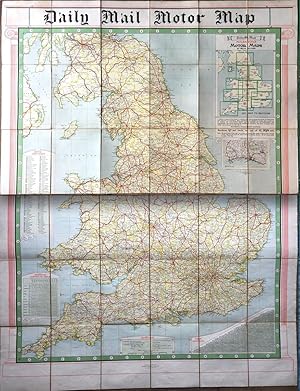
Daily Mail Milestone Motor Map: England: North Section and South Section together in slipcase.
Published by The Daily Mail, George Philip & Son, undated [c.1920s]., London:, 1920
Map First Edition
Map. Condition: Near Fine in worn slipcase. First or early edition. Both maps consist of 18 foldout panels on the original backing of brown cloth. Scale 1:500,000, 8 miles to 1 inch. Each map is 10.5x8ins folded, or c.31.5x48ins opened. Combined, they form a map 5' x 4': handy for the motorist with a flat-bed trailer on which to lay them out. Bright and clean, with no tears. Slipcase adequate but showing some wear and with a split at the bottom edge. 'With Index' is printed on the slipcase, but the only Index here is that of Motor Marks printed on the maps, as are the Perpetual Lighting-Up Table and a Table of Distances.
-
Philips Authentic Imperial Maps for Tourists and Travelers United States North-Eastern
Published by George Philip & Son, London, 1910
Map
25 x19 1/4 inches. This is a medium scale map designed to be carried by tourists and travelers. It seem that the detached cover would indicate considerable usage. The map lays out the north-east section of the United States from North Carolina in the South to Lake Huron in the west. Additionally the densely settled areas of Canada are shown to the State of Maine in the east. There is much to be said of British cartography. This map epitomizes. that heritage with well composed coated in pleasing colors. There are inset maps of Boston, New York, Washington DC, Baltimore, Philadelphia, Cleveland, Piits burgh and Niagara & Buffalo. The inset of Buffalo and Niagara is larger than New York City indicating the importance of the attraction for tourists. The Exhibition in Buffalo was in 1901 which heightened awareness of that city that most likely carried over for sometime. Map is in very good conf=dition with the from cover detached.
-

Philips' Chart of the Stars - Stars of the Middle Heavens -
Published by George Philip & Son Ltd; The London Geographical Institute, London, 1944
Seller: CURIO, Cleethorpes, North East Lincolnshire, United Kingdom
Seller rating 5 out of 5 stars
Map
Soft cover. Condition: Very Good. No Jacket. Linen folding map. Original blue card covers measuring 20cm x 13cm, folds out to 115cm x 93cm. Not library copy, no splits on folds, no inscriptions. (48/3).
-

United States. Scale 1:7,500,000 (120 Miles=1 Inch).
Published by LondonGeorge Philip & Son c., 1900
Seller: Robert Frew Ltd. ABA ILAB, London, United Kingdom
Association Member: ABA ILAB PBFA
Seller rating 5 out of 5 stars
Map
Original colour-printed map of the United States (54 x 67.5 cm) including inset maps of Alaska, New York Harbour, the District of Columbia, and Puerto Rico and the Virgin Islands, backed onto linen and folding between publishers' original orange cloth covers with advertisements to inner cover and verso. The map shows the railways, canals, submarine cables, and steamer routes. Generally an excellent clean copy.
-
Turkey, Syria and Iraq (Mesopotamia) with Transcaucasia / Philips Authentic Imperial Maps for Tourists and Travellers - Turkey, Syria, Iraq and Transcaucasia [cover title]
Published by G. Philip & Son, London, 1944
Map
Soft cover. Condition: Very Good. Colour paper map 67 x 55cm folding into original brown printed wraps 11 x 20cm, with publisher's adverts to inner panels. Map very good except for a couple of short fold tears, one of which with scuffing along the edges in the Mediterranean Sea. Wraps very good, worn to extremities with previous owner's name written to the front. Scale 55 miles to 1 inch or 1:3,500,000. Dated 1944, after the end of the Mandate in Lebanon, and declaration of independence in Syria, neither of which are marked as French Mandates. Palestine and Trans-Jordan are still marked as British Mandates. Features include oil pipelines, caravan routes, road, rail, shipping routes, ancient sites etc.
-

Philips Authentic Imperial Maps for Tourists and Travellers - Syria and Palestine showing Ancient Sites and their Modern Identifications
Published by G. Philip & Son, London, 1920
Map
Soft cover. Condition: Very Good. Colour paper map with 2 insets, 55 x 69cm folding into original yellow printed wraps 11 x 20cm, with publisher's adverts to inner panels. Map yellowing, near fine except for perforations along fold. Wraps good, worn to edges, with Chinese language institution stamps to the front. Undated, but Mandate era 1920s-1936, with the main map, Syria and Palestine, 18 miles to 1 inch, showing "The Alawis" and "Jebel ed Druz" as separate entities. The districts of Palestine are numbered for 1) Northern, 2) Southern, and 3) Jerusalem. Principal features are Zionist settlements, roads, and rail, shipping routes and submarine cables. The inset "Palestine showing Physical Features, Ancient Sites, and their Modern Identifications" on a scale of 13 miles ot 1 inch. features Biblical locations as well as Zionist settlements, roads and rivers etc, with colour coding for altitude. The inset plan "Modern Jerusalem" 1:25,000, shows Armenian, Christian, Jewish, and Mohammedan Quarters, principal churches and mosques. (SL#100).
-
Philips Authentic Imperial Maps for Tourists and Travellers - Syria and Palestine showing Ancient Sites and their Modern Identifications [cover title]
Published by G. Philip & Son, London, 1920
Map
Soft cover. Condition: Very Good. Colour paper map with 2 insets, 55 x 69cm folding into original yellow printed wraps 11 x 20cm, with publisher's adverts to inner panels. Map yellowing, near fine except for perforations along fold. Wraps good, worn to edges, with Chinese language institution stamps to the front. Undated, but Mandate era 1920s-1936, with the main map, Syria and Palestine, 18 miles to 1 inch, showing "The Alawis" and "Jebel ed Druz" as separate entities. The districts of Palestine are numbered for 1) Northern, 2) Southern, and 3) Jerusalem. Principal features are Zionist settlements, roads, and rail, shipping routes and submarine cables. The inset "Palestine showing Physical Features, Ancient Sites, and their Modern Identifications" on a scale of 13 miles ot 1 inch. features Biblical locations as well as Zionist settlements, roads and rivers etc, with colour coding for altitude. The inset plan "Modern Jerusalem" 1:25,000, shows Armenian, Christian, Jewish, and Mohammedan Quarters, principal churches and mosques.
-
Turkey, Syria and Iraq (Mesopotamia) with Transcaucasia / Philips Authentic Imperial Maps for Tourists and Travellers - Turkey, Syria, Iraq and Transcaucasia [cover title]
Published by G. Philip & Son, London, 1920
Map
Soft cover. Condition: Very Good. Colour paper map 66 x 55cm folding into original yellow printed wraps 11 x 20cm, with publisher's adverts to inner panels. Map yellowing, near fine except for short tears along folds. Wraps very good, worn to edges. Scale 55 miles to 1 inch or 1:3,500,000. Undated, but this edition appears to be early in the Mandate with demilitarised zones shown on Turkey's borders with Iraq, Greece and Bulgaria, the names Mesopotamia and Iraq are both used, and Ottoman Vilayets are shown. Palestine and Trans Jordan are identified as British Mandates, Iraq / Mesopotamia as a sovereign state under British Mandate, and Syria as French, with Alawiya, Jebel Druse, and Great Lebanon marked as separate entities. Saudi Arabia hs not come into being, with just the Hejaz labelled.
-
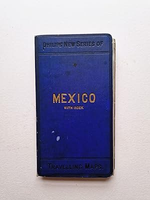
Mexico with Index/ Mexico and Central America
Published by George Philip & Son Ltd London, Liverpool, 1900
Seller: Angelika C. J. Friebe Ltd. - MapWoman, Dorking, United Kingdom
Seller rating 4 out of 5 stars

Map
Hardcover. Condition: Fair. colourprinted folding map; overall 53 x 64 cm, folds down to 17 x 9 cm. folds as issued; some discolouration; some wear and tear; some creases; some minor marginal tears not affecting the image; some small tears in crossfolds; o/w g cond. blue cloth binding with index; wear and tear; some staining and soiling; o/w fair cond. A very attractive and very detailed map of Mexico and Central America, with parts of Southern America. With inset if Isthmus of Panama.
-
Syria - Philips New Series of Imperial Maps for Tourists & Travellers [series title] / Philips Travelling Maps [cover title]
Published by G. Philip & Son, London, 1910
Map
Hardcover. Condition: Very Good. Colour map including large inset 56 x 70cm, dissected in 24 sections mounted on linen, folding into original red cloth case with black titles, and publisher's adverts to inner panels 11 x 19cm. Map and case very good with some marks, and inscription to advert panel. The adverts identify this as part of Philips' New Series of Imperial Maps for Tourists and Travellers, price 4/-. The main map, 69.15 miles to 1 degree, covers the Levantine coast from the Gulf of Iskenderun to the Dead Sea, and inland beyond Deir el Zor in Al Gezireh (Mesopotamia) (NE quadrant). Colour borders show Ottoman administrative divisions. Features include the Hejaz and other railways, Egyptian and Syrian Hajj routes to Mecca, steamer routes, submarine cables, relief by hachures, and heights in feet. The SE quadrant contains "The Sinai Peninsula and Egyptian Frontier", a continuation of the main map southwards on a reduced scale. The map is undated, but the frontier is the Rafah to Aqaba line imposed by the British on the Ottomans in 1906 to better defend Suez, and it pre-dates the Mandates.
-
Persia, Afghanistan and Beluchistan (Cover title: Philips New Series of Travelling Maps - Persia with Index)
Published by George Philip & Son, London and Liverpool, 1890
Map
Hardcover. Condition: Very Good. Cloth backed colour map 65 x 53cm, folding into the original blue cloth case titled in gilt and black 10 x 19cm, complete with 42pp Index bound inside the front, and (1)pp publisher's adverts facing. Map fine. Index very good, foxed, with corner creasing and short tears to front fore-edge with minor loss. Case very good. Previous owner's inscription penciled to the adverts: "28 piasters - Constantinople Oct. 23/99 / WL Whipple". This may be the Reverend William L. Whipple, who was agent of the American Bible Society in Persia for 30 years up to 1896 (d. 1902). Scale approx 1 inch to 65 miles. Features include submarine cables and railways. It is undated, but progress on the Trans-Caspian Railway puts it from 1888 when it reached Samarkand to before 1897-8 when the Russians built the line from Merv to Kushk on the Afghan border and extended from Samarkand to Tashkent and Andijan, neither of which are drawn on. It thus tracks Russian imperial expansion through Central Asia. It also shows the furthest extent of the Ottoman Empire in Asia, with the Arabian Peninsula side of the Persian Gulf marked as "Turkish Empire". Settlements shown along the Arabian side include Kuweit, Bahrain, and some of the Emirates, including Abu Dhabi, Sharjah, Ras al Khaimah, and Fujairah. Gwadar in Beluchistan is marked "to Oman".
-
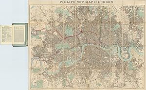
Philips' New Map of London Extending Four and a Half Miles Round Charing Cross.
Published by London & LiverpoolGeorge Philip & Son c., 1898
Seller: Robert Frew Ltd. ABA ILAB, London, United Kingdom
Association Member: ABA ILAB PBFA
Seller rating 5 out of 5 stars
Map
Engraved folding map of London (overall dimensions 78 x 101 cm, map dimensions 73 x 99 cm) with original hand-colour, dissected into 40 sections and backed onto cloth, folding between original gilt-lettered green cloth boards. Extends from Finsbury park in the north, Plaistow in the east, Streatham Hill in the south, and Barnes in the east. With accompany index in blue paper wrappers (pp.4) detailing chief places of interest, public buildings, principal hospitals, railways, and principal exhibitions, and places of amusement in London attached to inside cover. Light scuffing to boards, map in excellent condition. (Hyde, 223).
-
Stanford's General Map of Central and Southern Africa
Published by Edward Stanford, London, 1968
Map
No Binding. Condition: Fair. Colour pictorial paper map 78 x 104cm, folded down to 25 x 31cm. Fair, with pinholes and tape residue to corners and edges, small chip to top left corner (not affecting image), and some closed tears. 1:5,500,000 or 88 miles to 1 inch, including inset of Madagascar. Features include settlements indicated by size, principal and other railways, principal roads, principal airports, pipelines, canals, and heights in feet. This attractive map was intended for display, with numerous illustrations in the border, showing wildlife, geographical features, tribal peoples, modern industries, etc.
-
No Binding. Condition: Good. Colour pictorial paper map 78 x 104cm, folded down to 25 x 31cm. Good, with pinholes and tape residue to corners, and some closed tears. 1:5,500,000 or 88 miles to 1 inch. The area is bounded by Libya and Egypt (NW), Congo and Tanzania (SW), and the Arabian Peninsula (NE). Features include settlements indicated by size, principal and other railways, principal roads, principal airports, pipelines, canals, and heights in feet. This attractive map was intended for display, with numerous illustrations in the border, showing wildlife, geographical features, tribal peoples, traditional fishing boats, antiquities, architecture, arts and crafts, etc.
-
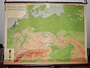
Philips' Comparative Map of Central Europe and the Low Countries (Large Pull Down Map)
Published by George Philip & Son, 1940
Seller: Sequitur Books, Boonsboro, MD, U.S.A.
Association Member: IOBA
Seller rating 5 out of 5 stars
Map
Maps. Condition: Fair. 83 x 114 cm. Color map mounted on muslin, wood rods top and bottom. Some chipping, wear. Scale 1:1,500,000. 1 in. = 24 mi. ; (E 4--E 28/N 56--N 46). Relief shown by gradient tints and spot heights. "Projection: conical with two standard parallels." Shows railway and steamship routes. Philips' comparative wall atlas of the countries of Europe. Note: This is a large, heavy map. Additional postage will apply depending on delivery location.
-
Philip's Regional Wall Map of Nigeria (Large Pull Down Map)
Published by George Philip & Son, London Geographical Institute, 1976
Seller: Sequitur Books, Boonsboro, MD, U.S.A.
Association Member: IOBA
Seller rating 5 out of 5 stars
Map
Maps. Condition: Very Good. 96 x 120 cm. Color map mounted on muslin, wooden rods top and bottom. Scale 1:1,400,000, international Polyconic projection., (E 4--E 14/N 14--N 4). Note: This is a large, heavy map. Additional postage will apply depending on delivery location.
-
Philip's Regional Wall Map of China (Large Pull Down Map)
Published by George Philip & Son, London, 1963
Seller: Sequitur Books, Boonsboro, MD, U.S.A.
Association Member: IOBA
Seller rating 5 out of 5 stars
Map
Maps. Condition: Very Good. 83 x 119 cm. Mounted on muslin, wood rods top and bottom. Relief shown by gradient tints, form lines, and spot heights. Scale 1:5,000,000 ;, Bonne projection, (E 70--E 140/N 50--N 20). Note: This is a large, heavy map. Additional postage will apply depending on delivery location.
-

Egypt.
Published by LondonGeorge Philip & Son Ltd. & Edward Stanford Ltd. Fleet Street & Long Acre ., 1952
Seller: Robert Frew Ltd. ABA ILAB, London, United Kingdom
Association Member: ABA ILAB PBFA
Seller rating 5 out of 5 stars
Map
Colour printed map of Egypt (52 x 72 cm; overall 54.5 x 76 cm) folded into 20 sections contained within the publisher's original colour printed covers. Japanese MS lettering to front cover, and publisher's advertisements to rear cover. Folds down to 12.5 x 20 cm. Contemporary purple Japanese ink rubber stamps to inside front cover, verso of first map fold, and verso of one other map fold. In addition to the general map (scale 1:100,000), there is an inset of a physical map of 'Egypt and the Nile Valley' (scale 1:600,000) with mileage scales and a coloured table of land elevations; another second inset map of 'Anglo-Egyptian Sudan' with an explanation of Arabic terms. The general map has mileage scales, and a symbols key. Good condition.
-

'AMERICAN, ASIATIC & AFRICAN FLAGS'. Thirty three Flags headed by the 'Stars and Stripes' of the United States. Published by the
Published by London Geographical Institute ca. 1912, 1912
Map
Full colour illustrations on one page, 35 x 23 cm.
-
Philip's Comparative Map of the British Isles in Relation to the Continent (Large Pull Down Map)
Published by George Philip & Son ; Denoyer-Geppert [distributor], London, Chicago, 1930
Seller: Sequitur Books, Boonsboro, MD, U.S.A.
Association Member: IOBA
Seller rating 5 out of 5 stars
Map
Maps. Condition: Fair. 95 x 120 cm. Mounted on muslin, wood rods top and bottom. Chipping along top margin close to rod. Relief shown by gradient tints and spot heights. "Projection: conical, with two standard parallels." Shows railway and steamship routes. Scale 1:1,500,000. 1 in. = 24 mi. ;, Conic projection, (W 10--E 14/N 60--N 48). Note: This is a large, heavy map. Additional postage will apply depending on delivery location.
-
Philips' Smaller School-Room Map of Africa (Large Pull Down Map)
Published by George Philip ; Denoyer-Geppert Co., 1963
Seller: Sequitur Books, Boonsboro, MD, U.S.A.
Association Member: IOBA
Seller rating 5 out of 5 stars
Map
Maps. Condition: Fair. 106 x 94 cm. Large wall map, with wooden rods, top and bottom. Some spotting to the map. "Projection: Azimuthal equidistant." Relief shown by spot heights. Note: This is a large, heavy map. Additional postage will apply depending on delivery location.
-

Belgium
Published by Philip & Son, Liverpool, 1860
Seller: Antiquariat Reinhold Berg eK Inh. R.Berg, Regensburg, Germany
Seller rating 5 out of 5 stars
Map
Lithograph, original hand colored in outline. Decorative double page hand colored lithograph antique map, showing detailed Belgum. Hand colored decorative in outline and wash when published, piano key border. Caxton Buildings, Liverpool, 1859. The printing works of George Philip & Son Ltd were situated here.Philip used cartographers such as John Bartholomew the elder, August Petermann, and William Hughes to produce maps on copper plates. Philip then had these printed and hand-coloured by his women tinters. By the time he produced his county maps of 1862 he was using machine coloured maps produced on power-driven lithographic presses. 'His maps ranged from the expensive Imperial Library Atlas (1864) to an atlas costing as little as 3d. and, although the bulk of his production was for the commercial, and particularly the educational market, he also produced important scientific maps, notably of North America, especially the Arctic and Pacific Northwest, and of the West Indies. The firm supplied atlases, geographical and history books, school textbooks, and an array of educational books and equipment. The company also produced textbooks for overseas countries, starting with an atlas for Australian schools in 1865 and for New Zealand in 1869. The demand from board schools, established after 1870, enabled further expansion in the market for general textbooks, school stationery, atlases and wall maps, etc Philip also employed many noted writers including the geographer and historian John Francon Williams who wrote, compiled and edited many books for the company from 1881 over a 20-year period. (Wikipedia) In excellent condition. Original center fold as issued. 50.8 x 60 cm (20 x 23,5 inches).


![Seller image for Arabia, the Red Sea, and the Valley of the Nile, including Egypt, Nubia, and Abyssinia (Philips New Series of Imperial Maps for Tourists & Travellers) / Philips Travelling Maps - Arabia with Index [cover title] for sale by Dendera](https://pictures.abebooks.com/inventory/md/md32342642729.jpg)

![Seller image for Turkey, Syria and Iraq (Mesopotamia) with Transcaucasia / Philips Authentic Imperial Maps for Tourists and Travellers - Turkey, Syria, Iraq and Transcaucasia [cover title] for sale by Dendera](https://pictures.abebooks.com/inventory/md/md30961909419.jpg)
![Seller image for Philips Authentic Imperial Maps for Tourists and Travellers - Syria and Palestine showing Ancient Sites and their Modern Identifications [cover title] for sale by Dendera](https://pictures.abebooks.com/inventory/md/md30961912152.jpg)
![Seller image for Turkey, Syria and Iraq (Mesopotamia) with Transcaucasia / Philips Authentic Imperial Maps for Tourists and Travellers - Turkey, Syria, Iraq and Transcaucasia [cover title] for sale by Dendera](https://pictures.abebooks.com/inventory/md/md30961908535.jpg)
![Seller image for Syria - Philips New Series of Imperial Maps for Tourists & Travellers [series title] / Philips Travelling Maps [cover title] for sale by Dendera](https://pictures.abebooks.com/inventory/md/md30961905699.jpg)