Order Total (1 Item Items):
Shipping Destination:

George Philip London Geographical Institute (23 results)
Feedback
Skip to main search results
Search filters
Product Type
- All Product Types
- Books (3)
- Magazines & Periodicals (No further results match this refinement)
- Comics (No further results match this refinement)
- Sheet Music (No further results match this refinement)
- Art, Prints & Posters (No further results match this refinement)
- Photographs (No further results match this refinement)
- Maps (20)
- Manuscripts & Paper Collectibles (No further results match this refinement)
Condition
- All Conditions
- New (No further results match this refinement)
- Used (23)
Binding
Collectible Attributes
- First Edition (2)
- Signed (No further results match this refinement)
- Dust Jacket (No further results match this refinement)
- Seller-Supplied Images (22)
- Not Print on Demand (23)
Language (1)
Price
- Any Price
- Under � 20 (No further results match this refinement)
- � 20 to � 35 (No further results match this refinement)
- Over � 35
Free Shipping
Seller Location
Seller Rating
-

The peoples' atlas : the world transformed / literary supplement by Cecil Roberts
Published by London : George Philip and Son, 1922
First Edition
� 74.95
Convert currencyFree shipping from U.S.A. to United KingdomQuantity: 1 available
Add to basketFirst Edition. Very good copy in the original title-blocked cloth. Spine bands and panel edges slightly dust-dulled and rubbed as with age, spine somewhat worn. Remains quite well preserved overall; internally tight, bright and clean. Physical description; 136 pages : maps (color), diagrams, illustrations ; 34 cm. Notes; Includes index. Subjects; Atlases Great Britain. Scales differ. 1 Kg.
-

Hardcover. Condition: Good. London Geographical Institute (illustrator). HB 3rd Edition. Maroon cloth boards. Gilt titles front + spine. 40.6 x 28.2cm. 4 pages of info. 158 pages of maps, flags, general geographical info. 4 pages of census returns for GB + USA. 93 index pages. f/c large maps throughout. 'A series of 160 pages of coloured maps, plans forming a complete geographical survey of the international relationships of the new era, its territorial changes and commercial communications.' 'With an index of over 65,000 names. Condition: Front and back cover scuffed, cloth thinning on title frame + edges. General age/handling marks front and back. Wear top and bottom spine + corners, boards showing. e/ps mild freckling. Sporadic freckles on opening pages. Remainder clean, little wear, remarkable tight binding for such a large book, maps vibrant. Apart from cover and few opening pages, very good condition.
-

The peoples' atlas : the world transformed / literary supplement by Cecil Roberts
Published by London : George Philip and Son, 1922
First Edition
� 73.79
Convert currency� 9.23 shipping from Ireland to United KingdomQuantity: 1 available
Add to basketFirst Edition. Very good copy in the original title-blocked cloth. Spine bands and panel edges slightly dust-dulled and rubbed as with age, spine somewhat worn. Remains quite well preserved overall; internally tight, bright and clean. Physical description; 136 pages : maps (color), diagrams, illustrations ; 34 cm. Notes; Includes index. Subjects; Atlases Great Britain. Scales differ. 1 Kg.
-
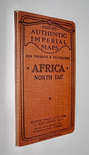
Philips' Authentic Imperial Maps for Tourists and Travellers - Africa North East Sheet
Published by George Philip and Son, London and Liverpool, 1930
Map
Hardcover. Condition: Very Good. Colour map, 121 miles to 1 inch (1:7,645,000) with 2 insets (Suez Canal, Sokotra), 54 x 70cm backed on linen folding into the original printed brown cloth case 11x19cm with publisher's adverts to inner panels. Undated c 1920s-30s. This stretches from the Libyan Desert to Lake Victoria in the west, to the Levant and Hejaz coasts in the east, with Mecca and Medina and related routes marked. Oases, Arab tribes, imperial possessions, railways, air, sea and cable routes etc shown, with glossary in Arabic and English. Map very good, lightly tanned with slight wear to a couple of folds. Case near fine, rubbed to the extremities.
-

Philips' Chart of the Stars - Stars of the Middle Heavens -
Published by George Philip & Son Ltd; The London Geographical Institute, London, 1944
Seller: CURIO, Grimsby, N. E. Lincolnshire, United Kingdom
Seller rating 5 out of 5 stars

Map
Soft cover. Condition: Very Good. No Jacket. Linen folding map. Original blue card covers measuring 20cm x 13cm, folds out to 115cm x 93cm. Not library copy, no splits on folds, no inscriptions. (48/3).
-
Turkey, Syria and Iraq (Mesopotamia) with Transcaucasia / Philips Authentic Imperial Maps for Tourists and Travellers - Turkey, Syria, Iraq and Transcaucasia [cover title]
Published by G. Philip & Son, London, 1944
Map
Soft cover. Condition: Very Good. Colour paper map 67 x 55cm folding into original brown printed wraps 11 x 20cm, with publisher's adverts to inner panels. Map very good except for a couple of short fold tears, one of which with scuffing along the edges in the Mediterranean Sea. Wraps very good, worn to extremities with previous owner's name written to the front. Scale 55 miles to 1 inch or 1:3,500,000. Dated 1944, after the end of the Mandate in Lebanon, and declaration of independence in Syria, neither of which are marked as French Mandates. Palestine and Trans-Jordan are still marked as British Mandates. Features include oil pipelines, caravan routes, road, rail, shipping routes, ancient sites etc.
-

Philips Authentic Imperial Maps for Tourists and Travellers - Syria and Palestine showing Ancient Sites and their Modern Identifications
Published by G. Philip & Son, London, 1920
Map
Soft cover. Condition: Very Good. Colour paper map with 2 insets, 55 x 69cm folding into original yellow printed wraps 11 x 20cm, with publisher's adverts to inner panels. Map yellowing, near fine except for perforations along fold. Wraps good, worn to edges, with Chinese language institution stamps to the front. Undated, but Mandate era 1920s-1936, with the main map, Syria and Palestine, 18 miles to 1 inch, showing "The Alawis" and "Jebel ed Druz" as separate entities. The districts of Palestine are numbered for 1) Northern, 2) Southern, and 3) Jerusalem. Principal features are Zionist settlements, roads, and rail, shipping routes and submarine cables. The inset "Palestine showing Physical Features, Ancient Sites, and their Modern Identifications" on a scale of 13 miles ot 1 inch. features Biblical locations as well as Zionist settlements, roads and rivers etc, with colour coding for altitude. The inset plan "Modern Jerusalem" 1:25,000, shows Armenian, Christian, Jewish, and Mohammedan Quarters, principal churches and mosques. (SL#100).
-
Philips Authentic Imperial Maps for Tourists and Travellers - Syria and Palestine showing Ancient Sites and their Modern Identifications [cover title]
Published by G. Philip & Son, London, 1920
Map
Soft cover. Condition: Very Good. Colour paper map with 2 insets, 55 x 69cm folding into original yellow printed wraps 11 x 20cm, with publisher's adverts to inner panels. Map yellowing, near fine except for perforations along fold. Wraps good, worn to edges, with Chinese language institution stamps to the front. Undated, but Mandate era 1920s-1936, with the main map, Syria and Palestine, 18 miles to 1 inch, showing "The Alawis" and "Jebel ed Druz" as separate entities. The districts of Palestine are numbered for 1) Northern, 2) Southern, and 3) Jerusalem. Principal features are Zionist settlements, roads, and rail, shipping routes and submarine cables. The inset "Palestine showing Physical Features, Ancient Sites, and their Modern Identifications" on a scale of 13 miles ot 1 inch. features Biblical locations as well as Zionist settlements, roads and rivers etc, with colour coding for altitude. The inset plan "Modern Jerusalem" 1:25,000, shows Armenian, Christian, Jewish, and Mohammedan Quarters, principal churches and mosques.
-
Turkey, Syria and Iraq (Mesopotamia) with Transcaucasia / Philips Authentic Imperial Maps for Tourists and Travellers - Turkey, Syria, Iraq and Transcaucasia [cover title]
Published by G. Philip & Son, London, 1920
Map
Soft cover. Condition: Very Good. Colour paper map 66 x 55cm folding into original yellow printed wraps 11 x 20cm, with publisher's adverts to inner panels. Map yellowing, near fine except for short tears along folds. Wraps very good, worn to edges. Scale 55 miles to 1 inch or 1:3,500,000. Undated, but this edition appears to be early in the Mandate with demilitarised zones shown on Turkey's borders with Iraq, Greece and Bulgaria, the names Mesopotamia and Iraq are both used, and Ottoman Vilayets are shown. Palestine and Trans Jordan are identified as British Mandates, Iraq / Mesopotamia as a sovereign state under British Mandate, and Syria as French, with Alawiya, Jebel Druse, and Great Lebanon marked as separate entities. Saudi Arabia hs not come into being, with just the Hejaz labelled.
-
Syria - Philips New Series of Imperial Maps for Tourists & Travellers [series title] / Philips Travelling Maps [cover title]
Published by G. Philip & Son, London, 1910
Map
Hardcover. Condition: Very Good. Colour map including large inset 56 x 70cm, dissected in 24 sections mounted on linen, folding into original red cloth case with black titles, and publisher's adverts to inner panels 11 x 19cm. Map and case very good with some marks, and inscription to advert panel. The adverts identify this as part of Philips' New Series of Imperial Maps for Tourists and Travellers, price 4/-. The main map, 69.15 miles to 1 degree, covers the Levantine coast from the Gulf of Iskenderun to the Dead Sea, and inland beyond Deir el Zor in Al Gezireh (Mesopotamia) (NE quadrant). Colour borders show Ottoman administrative divisions. Features include the Hejaz and other railways, Egyptian and Syrian Hajj routes to Mecca, steamer routes, submarine cables, relief by hachures, and heights in feet. The SE quadrant contains "The Sinai Peninsula and Egyptian Frontier", a continuation of the main map southwards on a reduced scale. The map is undated, but the frontier is the Rafah to Aqaba line imposed by the British on the Ottomans in 1906 to better defend Suez, and it pre-dates the Mandates.
-
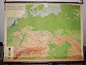
Philips' Comparative Map of Central Europe and the Low Countries (Large Pull Down Map)
Published by George Philip & Son, 1940
Seller: Sequitur Books, Boonsboro, MD, U.S.A.
Association Member: IOBA
Seller rating 5 out of 5 stars
Map
� 72.21
Convert currency� 24.35 shipping from U.S.A. to United KingdomQuantity: 1 available
Add to basketMaps. Condition: Fair. 83 x 114 cm. Color map mounted on muslin, wood rods top and bottom. Some chipping, wear. Scale 1:1,500,000. 1 in. = 24 mi. ; (E 4--E 28/N 56--N 46). Relief shown by gradient tints and spot heights. "Projection: conical with two standard parallels." Shows railway and steamship routes. Philips' comparative wall atlas of the countries of Europe. Note: This is a large, heavy map. Additional postage will apply depending on delivery location.
-
Philip's Regional Wall Map of Nigeria (Large Pull Down Map)
Published by George Philip & Son, London Geographical Institute, 1976
Seller: Sequitur Books, Boonsboro, MD, U.S.A.
Association Member: IOBA
Seller rating 5 out of 5 stars
Map
� 76.01
Convert currency� 24.35 shipping from U.S.A. to United KingdomQuantity: 1 available
Add to basketMaps. Condition: Very Good. 96 x 120 cm. Color map mounted on muslin, wooden rods top and bottom. Scale 1:1,400,000, international Polyconic projection., (E 4--E 14/N 14--N 4). Note: This is a large, heavy map. Additional postage will apply depending on delivery location.
-
Philip's Comparative Map of the British Isles in Relation to the Continent (Large Pull Down Map)
Published by George Philip & Son ; Denoyer-Geppert [distributor], London, Chicago, 1930
Seller: Sequitur Books, Boonsboro, MD, U.S.A.
Association Member: IOBA
Seller rating 5 out of 5 stars
Map
� 91.21
Convert currency� 24.35 shipping from U.S.A. to United KingdomQuantity: 1 available
Add to basketMaps. Condition: Fair. 95 x 120 cm. Mounted on muslin, wood rods top and bottom. Chipping along top margin close to rod. Relief shown by gradient tints and spot heights. "Projection: conical, with two standard parallels." Shows railway and steamship routes. Scale 1:1,500,000. 1 in. = 24 mi. ;, Conic projection, (W 10--E 14/N 60--N 48). Note: This is a large, heavy map. Additional postage will apply depending on delivery location.
-
Philips' Smaller School-Room Map of Africa (Large Pull Down Map)
Published by George Philip ; Denoyer-Geppert Co., 1963
Seller: Sequitur Books, Boonsboro, MD, U.S.A.
Association Member: IOBA
Seller rating 5 out of 5 stars
Map
� 98.81
Convert currency� 24.35 shipping from U.S.A. to United KingdomQuantity: 1 available
Add to basketMaps. Condition: Fair. 106 x 94 cm. Large wall map, with wooden rods, top and bottom. Some spotting to the map. "Projection: Azimuthal equidistant." Relief shown by spot heights. Note: This is a large, heavy map. Additional postage will apply depending on delivery location.
-
Asia Commercial Development (Large Pull Down Map)
Published by G. Philip & Son, London, 1940
Seller: Sequitur Books, Boonsboro, MD, U.S.A.
Association Member: IOBA
Seller rating 5 out of 5 stars
Map
� 190.02
Convert currency� 24.35 shipping from U.S.A. to United KingdomQuantity: 1 available
Add to basketMaps. Condition: Very Good. Large color map. Includes commodities of Asia (opium among other things listed). 88 x 112 cm. Mounted on muslin, wood rods top and bottom. Hanging hooks not included. 1:12,000,000 (approximately 200 miles= 1 inch) ;, Bonne's projection. Note: This is a large, heavy map. Additional postage will apply depending on delivery location.
-
India, Burma and Ceylon: Philips' Comparative Series of Large School Maps (Large Pull Down Map)
Published by George Philip & Son, 1940
Seller: Sequitur Books, Boonsboro, MD, U.S.A.
Association Member: IOBA
Seller rating 5 out of 5 stars
Map
� 342.04
Convert currency� 24.35 shipping from U.S.A. to United KingdomQuantity: 1 available
Add to basketMaps. Condition: Good. [Pre-WWII map of India] 182 x 243 cm. Mounted on muslin, wood rods top and bottom. Generally very good condition, with small taped section at center. Some fray where map meets the top rod. Scale: 1:3000000. Inset map: 1:12000000. Two inset maps. Note: This is a large, heavy map. Additional postage will apply depending on delivery location.
-
England and Wales: Philips' Comparative Series of Large School Maps (Large Pull Down Map)
Published by George Philip & Son, London Geographical Institute, 1933
Seller: Sequitur Books, Boonsboro, MD, U.S.A.
Association Member: IOBA
Seller rating 5 out of 5 stars
Map
� 342.04
Convert currency� 24.35 shipping from U.S.A. to United KingdomQuantity: 1 available
Add to basketMaps. Condition: Good. 158 x 177 cm. Mounted on muslin, wood rods top and bottom. A few old tears have been taped. No date, presumed circa 1930-1940. Note: This is a large, heavy map. Additional postage will apply depending on delivery location.
-
Oceana: Philips' Comparative Series of Large School Maps (Large Pull Down Map)
Published by George Philip & Son, 1930
Seller: Sequitur Books, Boonsboro, MD, U.S.A.
Association Member: IOBA
Seller rating 5 out of 5 stars
Map
� 380.04
Convert currency� 24.35 shipping from U.S.A. to United KingdomQuantity: 1 available
Add to basketMaps. Condition: Good. [Very Large Map of Australia, New Zealand, New Guinea, Hawaii, the Philippines (listed as American possessions) and the Oceanic islands, Coral Sea, Japan is shown as owning the Marshall and surrounding Caroline islands] 180 x 162 cm. Color map mounted on muslin, wood rods, top and bottom. Map in generally good condition, with a few small cracks. Some cracks have been taped, a few chips to paint with minor loss. Minor fraying to edge. No date, presumed circa 1930s. Includes insert map of Australasia. Note: This is a large, heavy map. Additional postage will apply depending on delivery location.
-
Asia: Philips' comparative series of large school maps (Large Pull Down Map)
Published by George Philip & Son, 1950
Seller: Sequitur Books, Boonsboro, MD, U.S.A.
Association Member: IOBA
Seller rating 5 out of 5 stars
Map
� 380.04
Convert currency� 24.35 shipping from U.S.A. to United KingdomQuantity: 1 available
Add to basketMaps. Condition: Good. 180 x 162 cm. Color map mounted on muslin, wood rods, top and bottom. Map in generally very good condition, with a few small cracks that have been taped. No date, presumed circa 1950. Korea and Indo-China (Vietnam) are shown as united. Goa is still a Portuguese colony. India and Pakistan are independent and Bangladesh is still part of Pakistan. 1:6000000. Note: This is a large, heavy map. Additional postage will apply depending on delivery location.
-
British Isles: Philips' Comparative Series of Large School Maps (Large Pull Down Map)
Published by George Philip & Son, London Geographical Institute, 1950
Seller: Sequitur Books, Boonsboro, MD, U.S.A.
Association Member: IOBA
Seller rating 5 out of 5 stars
Map
� 380.04
Convert currency� 24.35 shipping from U.S.A. to United KingdomQuantity: 1 available
Add to basketMaps. Condition: Good. Mounted on wooden rollers. 119 x 178 cm. One chip missing, a few small cracks, tears. Hanging hooks/bands not included. Scale 1:750000, (approximately 11.8 m. = 1 inch). Shows: railways, steamer routes and towns with over 500,000 inhabitants. Inset: Shetland Islands on the same scale. Note: This is a large, heavy map. Additional postage will apply depending on delivery location.
-
The Dominion of Canada : Philips' Comparative Series of Large School Maps (Large Pull Down Map)
Published by George Philip & Son, 1933
Seller: Sequitur Books, Boonsboro, MD, U.S.A.
Association Member: IOBA
Seller rating 5 out of 5 stars
Map
� 456.05
Convert currency� 24.35 shipping from U.S.A. to United KingdomQuantity: 1 available
Add to basketMaps. Condition: Very Good. Mounted on wooden rollers. 118 x 183 cm. (47 inches x 6') Relief shown by gradient tints and spot heights. Depths shown by gradient tints. Scale 1:3,000,000. 48 miles = 1 inch. Note: This is a large, heavy map. Additional postage will apply depending on delivery location.
-

Manitoba With Parts of Saskatchewan & Ontario
Published by George Philip & Son, Ltd c. 1890., London., 1890
Seller: Alexandre Antique Prints, Maps & Books, Toronto, ON, Canada
Seller rating 2 out of 5 stars

Map
� 570.06
Convert currency� 6.27 shipping from Canada to United KingdomQuantity: 1 available
Add to basketPart of Philip\'s New Series of Imperial Maps for Tourists and Travelers. The map provides detailed information on Manitoba, Eastern Saskatchewan and Northern Ontario. Various railways are shown. The map depicts rivers, settlements, and territories of the first nation people. , Size : 502x592 (mm), 19.75x23.30 (Inches), Hand Colored in Outline Very Good, Folding map laid on original canvas.
-

The Japanese Empire Including Korea & Sakhalin (c. 1900, The Harmsworth Atlas. Nos 129-130)
Publication Date: 1900
Seller: Tmecca Inc., Seoul, Korea, Republic of
Association Member: ILAB
Seller rating 5 out of 5 stars
Map
� 190.02
Convert currency� 14.75 shipping from Korea, Republic of to United KingdomQuantity: 1 available
Add to basketNo Binding. Condition: As New. 39 x 51.5cm It is taken from the Harmsworth Atlas and Gazetteer.
![Seller image for Turkey, Syria and Iraq (Mesopotamia) with Transcaucasia / Philips Authentic Imperial Maps for Tourists and Travellers - Turkey, Syria, Iraq and Transcaucasia [cover title] for sale by Dendera](https://pictures.abebooks.com/inventory/md/md30961909419.jpg)
![Seller image for Philips Authentic Imperial Maps for Tourists and Travellers - Syria and Palestine showing Ancient Sites and their Modern Identifications [cover title] for sale by Dendera](https://pictures.abebooks.com/inventory/md/md30961912152.jpg)
![Seller image for Turkey, Syria and Iraq (Mesopotamia) with Transcaucasia / Philips Authentic Imperial Maps for Tourists and Travellers - Turkey, Syria, Iraq and Transcaucasia [cover title] for sale by Dendera](https://pictures.abebooks.com/inventory/md/md30961908535.jpg)
![Seller image for Syria - Philips New Series of Imperial Maps for Tourists & Travellers [series title] / Philips Travelling Maps [cover title] for sale by Dendera](https://pictures.abebooks.com/inventory/md/md30961905699.jpg)