Order Total (1 Item Items):
Shipping Destination:

General Drafting Co (7 results)
Skip to main search results
Search filters
Product Type
- All Product Types
- Books (3)
- Magazines & Periodicals (No further results match this refinement)
- Comics (No further results match this refinement)
- Sheet Music (No further results match this refinement)
- Art, Prints & Posters (No further results match this refinement)
- Photographs (No further results match this refinement)
- Maps (3)
- Manuscripts & Paper Collectibles (1)
Condition Learn more
- New (No further results match this refinement)
- As New, Fine or Near Fine (No further results match this refinement)
- Very Good or Good (4)
- Fair or Poor (1)
- As Described (2)
Binding
- All Bindings
- Hardcover (1)
- Softcover (No further results match this refinement)
Collectible Attributes
- First Edition (1)
- Signed (No further results match this refinement)
- Dust Jacket (No further results match this refinement)
- Seller-Supplied Images (5)
- Not Print on Demand (7)
Language (2)
Free Shipping
- Free Shipping to U.S.A. (No further results match this refinement)
Seller Location
Seller Rating
-

State of New Jersey 1931 Official Road Map: Showing State Highways and Other Principal Roads
Language: English
Published by New Jersey. State Highway Commission, Trenton, 1931
Map
No Binding. Condition: Fair. No Jacket. A Fair copy of a Used map that has been folded and refolded. Extensive wear to map with creasing, tears, sunning and staining. Tears along folded creases. The complete map of the state is in color, the others are in black & white. The state map includes a legend and "Approximate Population of Cities and Towns (1930)" The reverse contains smaller illustrations of "Picture Plan Showing Proposed State Highways And Main Connecting Roads in The Vicinity Of The New Hudson River Bridge";"Camden And Philadelphia";"Jersey City - Newark - Elizabeth - Paterson And Other Metropolitan New Jersey Motor Roads";"Proposed Highway Junction Routes 21, 25, And 29 Newark, New Jersey"; Trenton; Atlantic City; New Brunswick; "Distribution Plaza For New Jersey State Highways Approaching The Hudson River Bridge Between Fort Lee And New York City";"Following are some main through routes of New Jersey, with State Highway Route Numbers and Mileages" Also includes an introduction by the New Jersey Commissioner of Motor Vehicles. "Notes: Panel title. Text, official highway signs, table of highway route numbers and mileage, 7 ancillary maps, 2 views, and illustrations on verso. Ancillary maps on verso: Picture plan showing proposed state highways and main connecting roads in the vicinity of the new Hudson River bridge -- Trenton -- Atlantic City -- New Brunswick -- Camden and Philadelphia -- Jersey City, Newark, Elizabeth, Paterson, and other Metropolitan New Jersey motor roads. Views on verso: Proposed highway junction routes 21, 25, and 29 Newark, New Jersey -- Distribution plaza for New Jersey state highways approaching the Hudson River Bridge between Fort Lee and New York. Panel art: State outline with profile of Indian face." "Mathematic map data: Scale approximately 1:252,500 (W 75�33?00?--W 73�50?00?/N 41�21?00?--N 38�55?00?)." "Physical description: 1 map : color ; 100 x 53 cm, folded to 26 x 10 cm.".
-

Full Cloth. Condition: Very Good. No Jacket. First Edition. FIRST EDITION, first printing. Original full blue cloth hardcover. Comes with business card of the manager of Gerneral Drafting Co and a sheet describing the book. No previous owner's names, not exlibrary. Overall in VERY GOOD condition. Size: 4to - over 9�" - 12" tall. Hardcover.
-
Map of Colonial Williamsburg, Williamsburg, Virginia.
Published by Williamsburg, Va.: Colonial Williamsburg Foundation, ca. 1960s., 1960
Seller: Wittenborn Art Books, San Francisco, CA, U.S.A.
Seller rating 5 out of 5 stars

Manuscript / Paper Collectible
Condition: Good. Folded color map measuring 18 x 24 inches, with index to buildings and sites of interest. Very good, suitable for framing.
-
Principal Highway Routes of the United States
Published by General Drafting Co. Inc, New York, 1933
Seller: Peruse the Stacks, ABAA, Gig Harbor, WA, U.S.A.
Association Member: ABAA CBA ILAB
Seller rating 5 out of 5 stars
Folding highway map of the US which includes inset map of "Washington, New York-Boston Section." Mileage table, text on the National Parks and the Transcontinental Tour, time zone map, and pictorial relief map on verso. Worldcat lists the date for this publication as 1931, but in the section on National Parks, the "new Trans-Mountain Highway," of Glacier National Park is mentioned, which was completed in 1933. An uncommon map. Folding map, 40x67cm, folded to 18x11cm. Good condition with toning, wear to folds, and a split to fold at bottom left panel. Former owner's annotations in pencil on both sides, with route from San Francisco to Providence traced neatly in green.
-
Southern Cruising Guide - Savannah, Jacksonville, Miami, Key West, Tampa, and Gulf Coast to New Orleans. [Gulf Coast Navigation, Florida Waterways, Illustrated Nautical Chart, Corporate Travel Ephemera]
Seller: Blind-Horse-Books (ABAA), DeLand, FL, U.S.A.
Association Member: ABAA ESA FABA ILAB IOBA
Seller rating 5 out of 5 stars
Map
Condition: Very Good. Cartography by General Drafting Co., New York. (illustrator). The boating map that sold Florida before Disney Large-format illustrated cruising chart produced by Standard Oil during the postwar leisure-boating boom, covering the Intracoastal Waterway and Gulf Coast routes from Savannah through Florida to New Orleans. Designed as both a functional navigation aid and a promotional travel object, the chart blends precise coastal cartography with pictorial lighthouse vignettes and regional landmarks, making it equally appealing to navigators and collectors of mid-century American ephemera. Physical description: Single large double-sided printed sheet, folded as issued, multiple-color offset lithography on thin stock, nautical soundings, route lines, compass roses, lighthouse and harbor illustrations, key map and legend panels, Standard Oil branding and General Drafting imprint present, approximate unfolded size large-format, exact measurements to be supplied. Condition: Paper is clean and supple with light, even age toning, original folds intact, minor handling wear at fold intersections, no losses, no tape repairs, graphics remain sharp and legible throughout, folds remain sound, issued folding format restated. Scarcity note: Surviving examples are increasingly scarce in clean, complete condition, particularly double-sided sheets retaining strong color and intact folds, most examples encountered show heavier fold wear or staining. The Southern Cruising Guide reflects the moment when recreational boating became accessible to middle-class Americans, supported by improved waterways, standardized navigation aids, and the rise of automobile and petroleum-sponsored tourism. General Drafting's crisp cartography is softened by charming illustrative elements that turn functional navigation into visual storytelling. The chart reads as both a working tool and a piece of Americana, merging maritime precision with aspirational travel culture. Historical significance Issued as part of Standard Oil's broader travel and mobility outreach, the chart illustrates how petroleum companies positioned themselves as partners in leisure and exploration, not merely fuel suppliers. It documents the growth of Florida and Gulf Coast boating infrastructure just prior to the massive postwar development boom, making it a valuable artifact for maritime, regional, and advertising history. Subjects: Intracoastal Waterway, Florida Gulf Coast, Recreational boating history, Maritime navigation, Petroleum advertising, Mid-century American design Maps and charts, Printed ephemera, Nautical material Single-sheet, double-sided folding nautical chart.
-
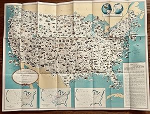
31 1/4 x 23 1/4 inches. Condition: Very good. Handsomely positioned and designed map. There are small illustrations that hit the high point of a states attractiveness to the user. The map was designed for classroom use. It was distributed out of NYC. Chicago was noted for having 33 trunk line railroads. Notre Dame made the area for Indiana. Isotopes was illustrated for Oak ridge, TN. The verso has map of the United States for trip planning. It shows highways. This is an attractive map and its pictorial attributes make it useful for a kids common area.
-
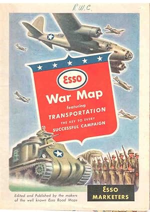
3 Esso War Maps - 1) War Map 2) War Map II, Featuring the World Island, Fortress Europe 3) The Pacific Theater
Published by New York [1944], New York, 1944
Seller: High Ridge Books, Inc. - ABAA, South Deerfield, MA, U.S.A.
Association Member: ABAA ESA ILAB SNEAB
Seller rating 5 out of 5 stars
3 folding maps, roughly in the form of folding road maps printed on both sides, published for Esso. All three maps are in fine condition, with two short tears at edges. All three maps promote Esso oil products by featuring the role of oil products in transportation logistics. The first piece has a map of the world showing transport routes. The second piece has a map of the world on one side, Europe on the other. The text mentions a book published in 1943, but the lack of any emphasis on France suggests that this was issued before June 6, 1944. The third map features the Pacific Theater of War, with a large map of the western Pacific Ocean and a more detailed map of the area around Japan. There are many inset maps of islands in the western Pacific, but not including the Solomon Islands, indicating that this was issued well after the Guadalcanal Campaign.


![Seller image for Southern Cruising Guide - Savannah, Jacksonville, Miami, Key West, Tampa, and Gulf Coast to New Orleans. [Gulf Coast Navigation, Florida Waterways, Illustrated Nautical Chart, Corporate Travel Ephemera] for sale by Blind-Horse-Books (ABAA)](https://pictures.abebooks.com/inventory/md/md32381554843.jpg)